 Arctic SDI catalogue
cumulative effects
Type of resources
Topics
Keywords
Contact for the resource
Provided by
Formats
Representation types
Update frequencies
status
-
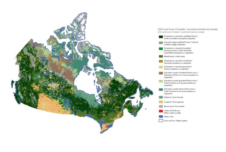
To support the implementation of the Impact Assessment Act, Natural Resources Canada (NRCan) received funding over five years (2018-23) for cumulative effects research to be conducted by three of NRCan’s science sectors – the Canada Centre for Mapping and Earth Observation within the Strategic Policy and Innovation Sector, the Canadian Forest Service, and the Geological Survey of Canada within the Lands and Minerals Sector – to conduct key earth observation, forest, and geoscience research. The overarching goal of this research is to inform regional assessment and related impact assessment processes, with a central focus on making the science and knowledge generated open and accessible to the public via the Open Science and Data Platform . Projects from all three sectors generated authoritative data on the status and trends of ecosystem parameters, as well as provided unique science and technical analysis, synthesis and advice on topics related to the cumulative effects of natural resource development. This Story Map synthesizes the cumulative effects science generated over the past five years. Through the Story Map platform, we hope to illustrate the national scale of this research program and the diversity of locations in Canada within which research has been conducted.
-

Cumulative Effects Program (CEP) remote camera detections for the Clear Creek cumulative effects monitoring project that occurred from August 2022 to September 2025. The data presented here is from July/August/September 2024- September 2025. Clear Creek remote camera locations can be found on GeoYukon in the Yukon Catalogue. This is a collaborative project with the First Nation of Na-Cho Nyäk Dun (FNNND) and Government of Yukon Department of Environment, with support from Tr’ondëk Hwëch’in. It was undertaken with the financial support of the Department of Environment, the Government of Canada through the federal Department of Environment and Climate Change (Grant Number: GCXE22C217 to FNNND) and through the Canada-Yukon Nature Agreement. For more information about this data please contact ce.cameratrapping@yukon.ca.
-
Cumulative Effects Program (CEP) remote camera detections for the Clear Creek cumulative effects monitoring project that occurred from August 2022 to September 2025. The data presented here is from July/August 2023- September 2024. Clear Creek remote camera locations can be found on GeoYukon in the Yukon Catalogue. This is a collaborative project with the First Nation of Na-Cho Nyäk Dun (FNNND) and Government of Yukon Department of Environment, with support from Tr’ondëk Hwëch’in. It was undertaken with the financial support of the Department of Environment, the Government of Canada through the federal Department of Environment and Climate Change (Grant Number: GCXE22C217 to FNNND) and through the Canada-Yukon Nature Agreement. For more information about this data please contact ce.cameratrapping@yukon.ca.
-
Cumulative Effects Program (CEP) remote camera detections for the Clear Creek cumulative effects monitoring project that occurred from August 2022 to September 2025. The data presented here is from August 2022- September 2023. Clear Creek remote camera locations can be found on GeoYukon in the Yukon Catalogue. This is a collaborative project with the First Nation of Na-Cho Nyäk Dun (FNNND) and Government of Yukon Department of Environment, with support from Tr’ondëk Hwëch’in. It was undertaken with the financial support of the Department of Environment, the Government of Canada through the federal Department of Environment and Climate Change (Grant Number: GCXE22C217 to FNNND) and through the Canada-Yukon Nature Agreement. For more information about this data please contact ce.cameratrapping@yukon.ca.