 Arctic SDI catalogue
treatment
Type of resources
Available actions
Topics
Keywords
Contact for the resource
Provided by
Formats
Representation types
Update frequencies
status
-

Layers of areas where biting insects are treated**This third party metadata element was translated using an automated translation tool (Amazon Translate).**
-

Layer of dots showing where custom packaging services in Manitoba are located. This dot layer shows where custom packaging services in Manitoba are located. A contract packager (subcontractor) is a company that manufactures and packages food products sold by other businesses. This list is not exhaustive and does not constitute a recommendation for services. For more information, visit the Manitoba Agriculture website. This point layer is used in the Manitoba Custom Packaging Services Map and the Manitoba Custom Packaging Services app.Fields included [Alias (Field Name): Field Description] Business Name (Business_Name): Contract Packer Business Name: Contract Packer Business Name Service Details (Service_Details): Summary of Services Provided by the Contract Packager Processing Capabilities (Business_Name): Business Name of Contract Packager: Business Name: Business Name of Contract Packager: Business Name: Contract Packager Business Name Service Details (Service_Details): Summary of Services Provided by the Contract Packager Processing Capabilities (Business_Name): Business Name of the Packager _transformation): List of specific food processing processes that the packager has package can provide Minimum production (Minimum_Production): Minimum number of units per order required by the package packager Types of packaging (packaging_types): List of packaging options offered by the packager Permits and licenses (Permis_and_licenses): List of permits and licenses that the packager has Certificates (Certifications): List of certifications obtained by the packager (e.g. organic, kosher): List of certifications obtained by the packager, halal, vegan, gluten-free) Unverified certifications ( Certifications_unverified_): List of unverified certifications obtained by the contract packager (e.g., healthy quality food, good manufacturing practices, British Retail Consortium) Contact information (Contact information): Name of the contact person for the package packager Contact email of the contact person Email of the contact person Email (Email_of_the_contact person): Email of the contact person Number of the contact person (Number_of_the_the_person_resource): Email of the contact person Resource (s): Telephone number of the contact person Address (Address): Municipal address of the packager at package City or town (City_or_village): City or village of the package packager Website (Site_Web): URL of the packager's website Logo URL (Url_du_logo): URL of the package packager logo Latitude (Latitude): Latitudinal coordinates of the entity's representative center (Latitude): Latitudinal coordinates of the entity's representative center in decimal degrees Longitude (Longitude): Longitudinal coordinates of the entity's representative center in decimal degrees **This third party metadata element was translated using an automated translation tool (Amazon Translate).**
-
Map showing where custom packaging services in Manitoba are located. This map shows where custom packaging services in Manitoba are located. A contract packager (subcontractor) is a company that manufactures and packages food products sold by other businesses. This list is not exhaustive and does not constitute a recommendation for services. For more information, visit the Manitoba Agriculture website. <o:p></o:p>This map uses the Manitoba contract packaging point layer and is part of the Manitoba contract packaging app. **This third party metadata element was translated using an automated translation tool (Amazon Translate).**
-

The Wastewater Systems Effluent Regulations (WSER), developed under the Fisheries Act, came into force in 2012 to manage wastewater releases by systems that collect an average daily influent volume of 100 cubic metres or more. The WSER also does not apply to any wastewater system located in the Northwest Territories, Nunavut and north of the 54th parallel in the provinces of Quebec and Newfoundland and Labrador. The WSER set national baseline effluent quality standards that are achievable through secondary wastewater treatment. The province of Quebec provided some combined sewer overflow data for 2020, which includes information on whether a discharge occurred at a combined sewer overflow point during the year. The map below shows the number of CSO points with at least one overflow event within each wastewater system. The map is available in both ESRI REST (to use with ARC GIS) and WMS (open source) formats. For more information about the individual reporting wastewater systems, datasets are available in either CSV or XLS formats. More information on the wastewater sector including the regulations, agreements, contacts and resource documents is available at: https://www.canada.ca/wastewater
-

The Wastewater Systems Effluent Regulations (WSER), developed under the Fisheries Act, came into force in 2012 to manage wastewater releases by systems that collect an average daily influent volume of 100 cubic metres or more. The WSER also does not apply to any wastewater system located in the Northwest Territories, Nunavut and north of the 54th parallel in the provinces of Quebec and Newfoundland and Labrador. The WSER set national baseline effluent quality standards that are achievable through secondary wastewater treatment. The map below presents data regarding compliance with the WSER effluent quality standards according to their averaging period. Wastewater systems must report on either a monthly, quarterly or annual basis. The dataset also includes the carbonaceous biochemical oxygen demand (CBOD) and suspended solids (SS) results for each wastewater system. Annual reporting: This map layer shows whether or not the wastewater systems met the WSER effluent quality limit according to an annual averaging period for carbonaceous biochemical oxygen demand CBOD or suspended solids SS. Quarterly reporting: This map layer shows whether or not the wastewater systems met the WSER effluent quality standards according to a quarterly averaging period. Note that a system that meets its CBOD limit or its SS limit for more than 75% of the time is considered to be in compliance with the effluent quality standards of the WSER. Monthly reporting: This map layer shows whether or not the wastewater systems met the WSER effluent quality standards according to a monthly averaging period. Note that a system that meets its CBOD limit or its SS limit for more than 75% of the time is considered to be in compliance with the effluent quality standards of the WSER. The map is available in both ESRI REST (to use with ARC GIS) and WMS (open source) formats. For more information about the individual reporting wastewater systems, datasets are available in either CSV or XLS formats. Data from Quebec and Yukon The data for Quebec municipalities (after 2017) is provided to the department separately through the equivalency agreement that was finalized in October 2018. Beginning in 2015, the data reported for the Yukon is provided to the department separately through an equivalency agreement finalized in 2014. More information on the wastewater sector including the regulations, agreements, contacts and resource documents is available at: https://www.canada.ca/wastewater
-

The Wastewater Systems Effluent Regulations (WSER), developed under the Fisheries Act, came into force in 2012 to manage wastewater releases by systems that collect an average daily influent volume of 100 cubic metres or more. The WSER also does not apply to any wastewater system located in the Northwest Territories, Nunavut and north of the 54th parallel in the provinces of Quebec and Newfoundland and Labrador. The WSER set national baseline effluent quality standards that are achievable through secondary wastewater treatment. The WSER require owners or operators of wastewater systems with combined sewers to submit an annual report on the total volume and the number of days wastewater is discharged per month via combined sewer overflow (CSO) points as a result of precipitation. The map below shows the volume of effluent (in cubic metres) discharged in a year from all CSO points situated within the collection area of a wastewater system. For the most part, the volumes provided to ECCC are estimates. Please note, a value of “999999999” in the dataset indicates that the volume data is unavailable and it does not mean that a volume of 999,999,999 m3 was released within the collection area of a wastewater system. The map is available in both ESRI REST (to use with ARC GIS) and WMS (open source) formats. For more information about the individual reporting wastewater systems, datasets are available in either CSV or XLS formats. Data from Quebec As of 2018, no combined sewer overflow volumes from Quebec municipalities are available since an equivalency agreement is now in effect. More information on the wastewater sector including the regulations, agreements, contacts and resource documents is available at: https://www.canada.ca/wastewater
-

The Wastewater Systems Effluent Regulations (WSER), developed under the Fisheries Act, came into force in 2012 to manage wastewater releases by systems that collect an average daily influent volume of 100 cubic metres or more. The WSER also does not apply to any wastewater system located in the Northwest Territories, Nunavut and north of the 54th parallel in the provinces of Quebec and Newfoundland and Labrador. The WSER set national baseline effluent quality standards that are achievable through secondary wastewater treatment. Under the WSER, owners or operators of wastewater systems discharging annual average daily effluent volumes greater than 2,500 m3 are required to determine and report on the acute lethality of the effluent. The map below presents the percentage of acute lethality test failures for the wastewater systems in Canada that conducted at least one acute lethality test according to the standards of the Wastewater Systems Effluent Regulations. The map is available in both ESRI REST (to use with ARC GIS) and WMS (open source) formats. For more information about the individual reporting wastewater systems, datasets are available in either Excel or CSV formats. Data from Quebec and Yukon As of 2018, no acute lethality results from Quebec municipalities are available since an equivalency agreement is now in effect. As of 2015, no acute lethality test results for wastewater systems in the Yukon are available as an equivalency agreement in is effect. More information on the wastewater sector including the regulations, agreements, contacts and resource documents is available at: https://www.canada.ca/wastewater
-
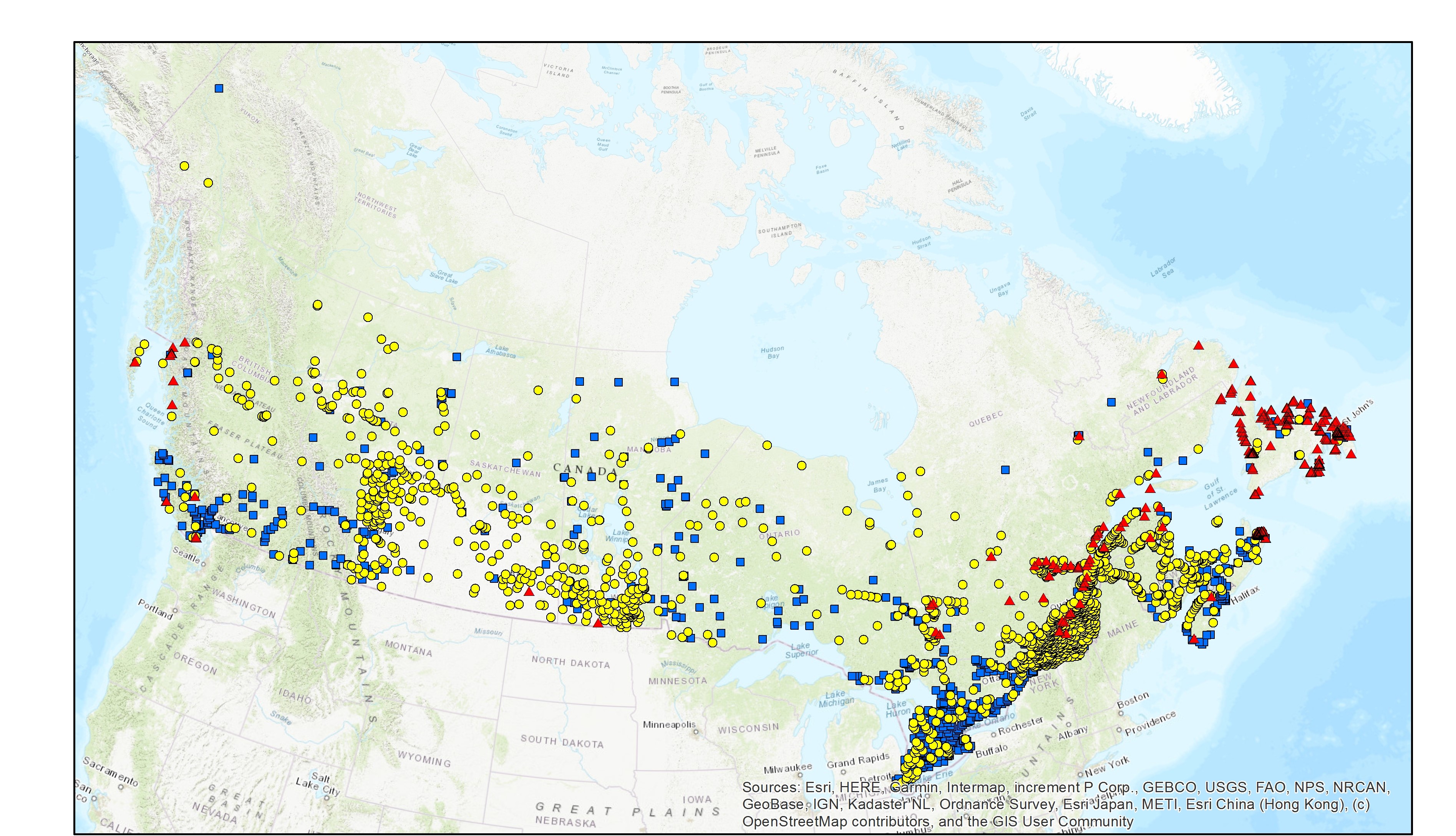
The Wastewater Systems Effluent Regulations (WSER), developed under the Fisheries Act, came into force in 2012 to manage wastewater releases by systems that collect an average daily influent volume of 100 cubic metres or more. The WSER also does not apply to any wastewater system located in the Northwest Territories, Nunavut and north of the 54th parallel in the provinces of Quebec and Newfoundland and Labrador. The WSER set national baseline effluent quality standards that are achievable through secondary wastewater treatment. The map below presents the wastewater system locations in Canada and the type of treatment they utilize (mechanical, lagoon or no treatment). The data is based on the information submitted to Environment and Climate Change Canada as of November 2022. Note that this layer does not represent the level of wastewater treatment or whether the system complies with the WSER. The map is available in both ESRI REST (to use with ARC GIS) and WMS (open source) formats. For more information about the individual reporting wastewater systems, datasets are available in either Excel or CSV formats at the resource listed below: “Wastewater Systems Effluent Regulations Reported Data”. Data from Quebec and Yukon The data for Quebec municipalities (after 2017) is provided to the department separately through the equivalency agreement that was finalized in October 2018. Beginning in 2015, the data reported for the Yukon is provided to the department separately through an equivalency agreement finalized in 2014. More information on the wastewater sector including the regulations, agreements, contacts and resource documents is available at: https://www.canada.ca/wastewater