 Arctic SDI catalogue

DFO.MAR-PED-Data-Request-Demande-de-donnes-DEP-MAR.MPO@dfo-mpo.gc.ca
Type of resources
Topics
Keywords
Contact for the resource
Provided by
Formats
Representation types
Update frequencies
status
-
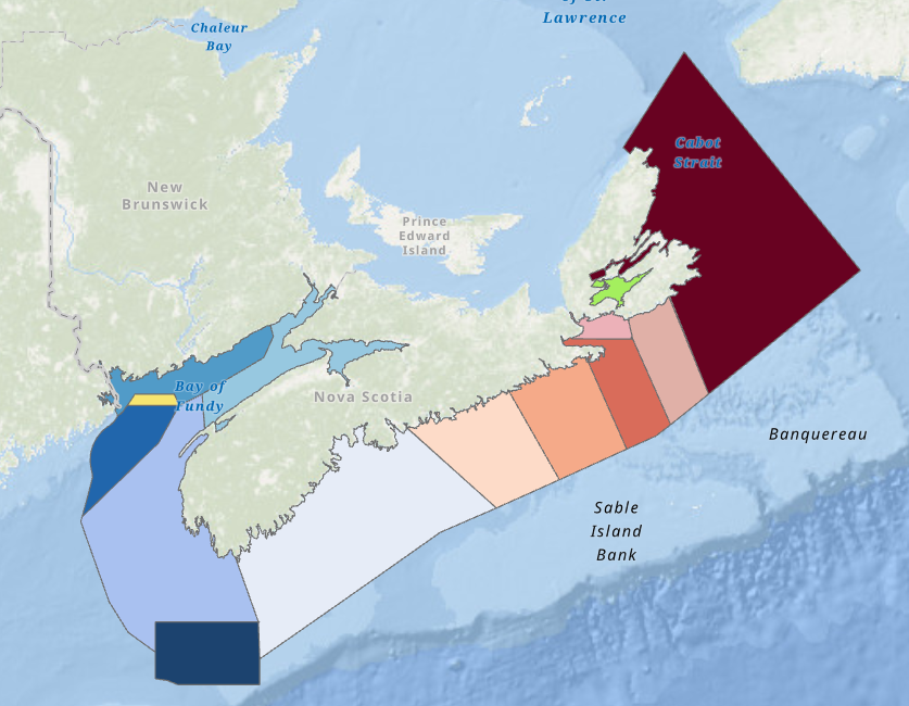
This report outlines the results of a project that created a series of maps tracking inshore historical Lobster fishing district boundaries from 1899 to present. This work has been part of Fisheries and Oceans Canada’s (DFO) Blue Economy Lobster Team (BELT) pilot project on the Lobster fishery. To provide the context for the use of historical information within fisheries research, this report provides a brief summation of the discipline of history, its purpose, and its methods. It also describes the different ways that historical data has been used to support the analysis of fisheries, and some of the ways that historians have integrated the techniques of natural and social sciences into their own work. It provides an overview of how the BELT has incorporated historical methods and methodologies into the team’s overall work. The report presents two sets of maps that outline geographical changes in Lobster fishing districts (called Lobster Fishing Areas after 1985) as well as changes in minimum legal size (MLS) and season length information. These maps help to inform a larger understanding of the historical Lobster fishery in the present-day Maritimes Region, and highlight several themes within the fishery. This includes the increasingly intensive regulation of the fishery over time, the inshore nature of the Lobster fishery for the majority of the twentieth century, the variability in the boundaries of Lobster districts over time, and the broad transition from a cannery-based market to a live Lobster market. The maps taken as a whole help to demonstrate consistency of the regulatory approach to Lobster over the twentieth century. However, there are limitations to the interpretive capacity of these maps, as more work should be done to investigate the specific reasoning behind why each change occurred. **Note: The outer boundaries depicted from 1899-1974 are not meant to represent areas where DFO or its predecessor departments had complete or authoritative control of the inshore fishery. In past regulations, districts were described as “on and along the coast.” The outer boundaries assigned to maps prior to 1985 were chosen to make the maps easy to understand relative to current lobster fishing areas.
-

The blue shark (Prionace glauca), is a species found in Atlantic Canadian waters which is commonly encountered in commercial and recreational fisheries. Pop-up Satellite Archival Tags (PSAT) and Smart Position and Temperature tag (SPOT) from Wildlife Computers were applied to blue sharks from 2004 to 2008 to collect data on depth (pressure), temperature and ambient light level (for position estimation). Deployments were conducted in Canada on commercial and recreational vessels from mid-August to early October, but mostly in September. A variety of tag models were deployed: PAT 4 (n=16), Mk10 (N=28), and SPOT3 (N=2) and 39 of 46 tags reported. The blue sharks tagged ranged in size from 124 cm to 251 cm Fork Length (curved); 30 were female, 15 were male and 1 was unknown sex. Time at liberty ranged from 4 – 210 days and 16 tags remained on for the programmed duration. Raw data transmitted from the PSAT’s after release was processed through Wildlife Computers software (GPE3) to get summary files, assuming a maximum swimming speed of 2m/s, NOAA OI SST V2 High Resolution data set for SST reference and ETOPO1-Bedrock dataset for bathymetry reference. The maximum likelihood position estimates are available in .csv and .kmz format and depth and temperature profiles are also in .csv format. Other tag outputs as well as metadata from the deployments can be obtained upon request from: warren.joyce@dfo-mpo.gc.ca or heather.bowlby@dfo-mpo.gc.ca.
-

"Fall" missions occur primarily in October and November, but sets from September and December are also present in the data. Collected data includes total catch in numbers and weights by species. Length frequency data is available for most species, as are the age, sex, maturity and weight information for a subset of the individual animals. Other data such as ageing material, genetic material, and stomach contents are often also collected, but are stored elsewhere. "Fall" cruises occur in September, October, November and December. Cite this data as: Clark, D., Emberley, J. Data of Maritimes Fall Research Vessel Survey. Published January 2021. Population Ecology Division, Fisheries and Oceans Canada, Dartmouth, N.S. https://open.canada.ca/data/en/dataset/5f82b379-c1e5-4a02-b825-f34fc645a529
-

These data consist of the Recreational Shark Fishing Tournament landings database (1993-2022 inclusive) and the Canadian Dart tag database (2006 onwards; updated annually). Both were collected by the Maritimes Science Division of Fisheries and Oceans Canada. The landings records include biological sampling from 4266 animals and the dart tag records include 4138 tagging and 97 recapture events to date. Potential users should consult Bowlby et al. (2022) for the description, management history, and technical details pertaining to these data. Information is focused on Blue Sharks because they were the primary species captured at recreational tournaments. Cite this data as: Bowlby, H., Joyce, W. Recreational Shark Fishing Tournament Landings Data and Canadian Dart Tag Database. Published January 2023 . Population Ecology Division, Fisheries and Oceans Canada, Dartmouth, N.S. https://open.canada.ca/data/en/dataset/4309f1f7-6779-416d-9660-c02f0f99b482
-
Fecundity of Atlantic herring (Clupea harengus) was estimated within five spawning areas (German Bank, Scots Bay, Seal Island, Southern Shore Nova Scotia, and Eastern Shore Nova Scotia) in Northwest Atlantic Fisheries Organization (NAFO) areas 4WX in 2019 and 2020. The objective of this project was to describe the fecundity-at-size (weight, length, and age) relationships among spawning grounds, compare these relationships to historical fecundity-at-size relationships, and assess the influence of changes in weight-at-age and fecundity over time to the reproductive potential of a unit of spawning stock biomass. Cite this data as: Barrett T. Data of: Fecundity of Herring in Divisions 4WX. Published: September 2021. Population Ecology Division, Fisheries and Oceans Canada, St. Andrews, N.B. https://open.canada.ca/data/en/dataset/e39b1318-c9f7-4686-b5e5-7d838c8ac99a
-

The lobster recruitment project is run by the Fishermen and Scientist Research Society (FSRS) through DFO funding. Fishermen participating in the lobster recruitment project collect information about lobster in their fishing area by fishing 2-5 scientific project traps (SPTs) (fished in fixed locations) within the regular commercial season. The SPTs used in all fishing areas are smaller than commercial traps and designed to primarily catch juvenile lobsters below the legal-size limit. These traps are additional to the vessel's legal number of commercial traps. The lobster recruitment project has more than 120 fishers participating from all LFAs along the Atlantic coast of Nova Scotia from LFA 27 in Cape Breton to LFA 35 in the Bay of Fundy (excluding LFA 28, who have not participated to-date). The number of fishermen per LFA and number of SPTs per fisherman are decided on by the LFA Advisory Committees. This decision considers how much additional effort they were comfortable having in the LFA (i.e. number of SPTs) and from how many traps each fisher could be reasonably expected to collect data. It is also important to have fishers dispersed enough to maximize study footprint. DFO Science consults on project design. SAMPLING METHODS: The fishers record the number, sex and length of lobsters captured in each SPT, as well as presence of eggs, tags or v-notch. Bottom temperatures are monitored by placing a temperature recorder in one of their SPTs for the entire lobster season. Cite this data as: Tibbets-Scott, S., Zisserson, B. Data of: Fishermen and Scientist Research Society (FSRS) Lobster Recruitment Trap Project. Published: November 2020. Population Ecology Division, Fisheries and Oceans Canada, Dartmouth, N.S. https://open.canada.ca/data/en/dataset/a88f9b4d-b59a-44f6-ae7e-d36550266940
-

The Fisheries and Oceans Canada (DFO) ecosystem surveys consist of research vessel survey data collected to monitor the distribution and abundance of fish and invertebrates throughout the Scotian Shelf, Bay of Fundy and Georges Bank. The surveys follow a stratified random sampling design, and include sampling of fish and invertebrates using a bottom otter trawl. These survey data are the primary data source for monitoring trends in species distribution, abundance, and biological condition within the region, and also provide data to the Atlantic Zonal Monitoring Program (AZMP) for monitoring hydrographic variability. Collected data includes total catch in numbers and weights by species. Length frequency data is available for most species, as are the age, sex, maturity and weight information for a subset of the individual animals. Other data such as ageing material, genetic material, and stomach contents are often also collected, but are stored elsewhere. “Spring” cruises occur in January, February, March and April, and focus on Georges Bank (i.e. 5Z). Cite this data as: Clark, D., Emberley, J. Data of MARITIMES SPRING RESEARCH VESSEL SURVEY. Published January 2021. Population Ecology Division, Fisheries and Oceans Canada, Dartmouth, N.S. https://open.canada.ca/data/en/dataset/fecf045a-95a2-4b69-8a40-818649a62716
-
“Summer” missions occur in June, July and August and these focus on the Scotian Shelf and Bay of Fundy (i.e. 4VWX 5Yb, expanding recently to include the Laurentian Channel and Georges Bank (5Zc). Collected data includes total catch in numbers and weights by species. Length frequency data is available for most species, as are the age, sex, maturity and weight information for a subset of the individual animals. Other data such as ageing material, genetic material, and stomach contents are often also collected, but are stored elsewhere. “Summer” cruises occur in May, June, July and August and these focus on the Scotian Shelf and Bay of Fundy (i.e. 4VWX). Cite this data as: Clark, D., Emberley, J. Data of MARITIMES SUMMER RESEARCH VESSEL SURVEYS. Published January 2021. Population Ecology Division, Fisheries and Oceans Canada, Dartmouth, N.S. https://open.canada.ca/data/en/dataset/1366e1f1-e2c8-4905-89ae-e10f1be0a164
-

The white shark (Carcharodon carcharias), is a species found in Atlantic Canadian waters which is encountered in commercial and recreational fisheries. Pop-up Satellite Archival Tags (PSAT) from Wildlife Computers were applied to white sharks from 2016 to the present to collect data on depth (pressure), temperature and ambient light level (for position estimation). Deployments were conducted in Canada and the United States (Cape Cod and South Carolina) on scientific charters, typically in summer. Tag models deployed included: Mk10 (N=1), and MiniPAT (N=29) and 22 of 27 tags reported with 3 still at liberty. One individual shark returned to the location of tagging 1 year later and the physical tag was recovered. Another tag was recovered 5 years after deployment. White sharks tagged ranged in size from 259 cm to 459 cm Total Length (curved) estimated; 15 were female, 13 were male, and 2 were of unknown sex. Time at liberty ranged from 48 – 377 days and to date, only 3 tags remained on the shark for the programmed duration. Tagging of white sharks is an ongoing study and data will be updated here when it becomes available. Raw data transmitted from the PSAT’s after release was processed through Wildlife Computers software (GPE3) to get summary files, assuming a maximum swimming speed of 2m/s, NOAA OI SST V2 High Resolution data set for SST reference and ETOPO1-Bedrock dataset for bathymetry reference. The maximum likelihood position estimates are available in .csv and .kmz format and depth and temperature profiles are also in .csv format. Other tag outputs as well as metadata from the deployments can be obtained upon request from: warren.joyce@dfo-mpo.gc.ca or heather.bowlby@dfo-mpo.gc.ca.
-

Spiny dogfish (Squlaus acanthias), is a species found in Atlantic Canadian waters which is encountered mostly in commercial fisheries. Pop-up Satellite Archival Tags (PSAT) from Wildlife Computers were applied to spiny dogfish from 2008 to 2009 to collect data on depth (pressure), temperature and ambient light level (for position estimation). Deployments were conducted in Canada on commercial fishing vessels from August to October. Wildlife Computers PSAT Mk10 (N=6) were used and 3 of 6 tags reported. One tag was found washed up on shore and was returned. The spiny dogfish tagged ranged in size from 80 cm to 96 cm Fork Length (curved); all 6 were female. Time at liberty ranged from 75 – 234 days and the 43 tags that reported remained on the sharks for the programmed duration. Raw data transmitted from the PSAT’s after release was processed through Wildlife Computers software (GPE3) to get summary files, assuming a maximum swimming speed of 2m/s, NOAA OI SST V2 High Resolution data set for SST reference and ETOPO1-Bedrock dataset for bathymetry reference. The maximum likelihood position estimates are available in .csv and .kmz format and depth and temperature profiles are also in .csv format. Other tag outputs as well as metadata from the deployments can be obtained upon request from: warren.joyce@dfo-mpo.gc.ca or heather.bowlby@dfo-mpo.gc.ca.