 Arctic SDI catalogue
CDED
Type of resources
Available actions
Topics
Keywords
Contact for the resource
Provided by
Years
Formats
Representation types
Update frequencies
status
Service types
-
This is a shaded relief cached Base Map that is utilizing the most commonly used datasets that are publically available from the Government of the North West Territories and the Government of Canada. It has been rendered from 1:25,000,000 down to 1:1,000 scales. This map is projected in Canada Lambert Conformal Conic projection to best represent the Canadian North. Individual layers are rendered to their appropriate level of zoom or scale. Below is a summary of each layer name and the scale that the layer becomes visible. The Base Map was created from a combination of Geo-Base Canvec vectors, Geo-Base WMS Services, and GNWT, Centre for Geomatics datasets. For Metadata on each individual dataset; review the REST end point description provided at www.apps.geomatics.enr.gov.nt.ca\ArcGIS\rest\services\GNWT\. For Metadata on Geo-Base WMS Service data sets visit; http://www.geobase.ca/geobase/en/wms/index.html This Base Map can be utilized with any other datasets; it provides a baseline for the best representation of the NWT. This map is designed to minimize the cartographic effect for users to build their own cartographic operational layer top of this Base Map.
-

Digital Elevation Model (DEM) for British Columbia produced by GeoBC. This data is the TRIM DEM converted to the Canadian Digital Elevation Data (CDED)format. The data consists of an ordered array of ground or reflective surface elevations, recorded in metres, at regularly spaced intervals. The spacing of the grid points is .75 arc seconds north/south. The data was converted into 1:50,000 grids for distribution. The scale of this modified data is 1:250,000 which was captured from the original source data which was at a scale of 1:20,000. The CDED format specification are available at ftp://ftp.geogratis.gc.ca/pub/nrcan_rncan/elevation/cdem_mnec/doc/CDEM_product_specs.pdf
-
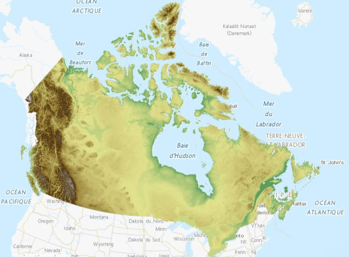
This collection is a legacy product that is no longer supported. It may not meet current government standards. The Canadian Digital Elevation Model (CDEM) is part of Natural Resources Canada's altimetry system designed to better meet the users' needs for elevation data and products. The CDEM stems from the existing Canadian Digital Elevation Data (CDED). In these data, elevations can be either ground or reflective surface elevations. A CDEM mosaic can be obtained for a pre-defined or user-defined extent. The coverage and resolution of a mosaic varies according to latitude and to the extent of the requested area. Derived products such as slope, shaded relief and colour shaded relief maps can also be generated on demand by using the Geospatial-Data Extraction tool. Data can then be saved in many formats. The pre-packaged GeoTiff datasets are based on the National Topographic System of Canada (NTS) at the 1:250 000 scale; the NTS index file is available in the Resources section in many formats.