 Arctic SDI catalogue
Geomatics
Type of resources
Available actions
Topics
Keywords
Contact for the resource
Provided by
Years
Formats
Representation types
Update frequencies
status
Service types
Scale
-
This project was carried out thanks to the financial support of component 2.2 of the MAMAH Regions and Rurality Fund (FRR). The updates were made using orthophotos from spring 2020. The project covers the territory of the MRCs of Haut-Saint-Laurent, Haute-Yamaska, Haute-Yamaska, Roussillon, Rouville, Vaudreuil-Soulanges as well as the agglomeration of Longueuil.**This third party metadata element was translated using an automated translation tool (Amazon Translate).**
-
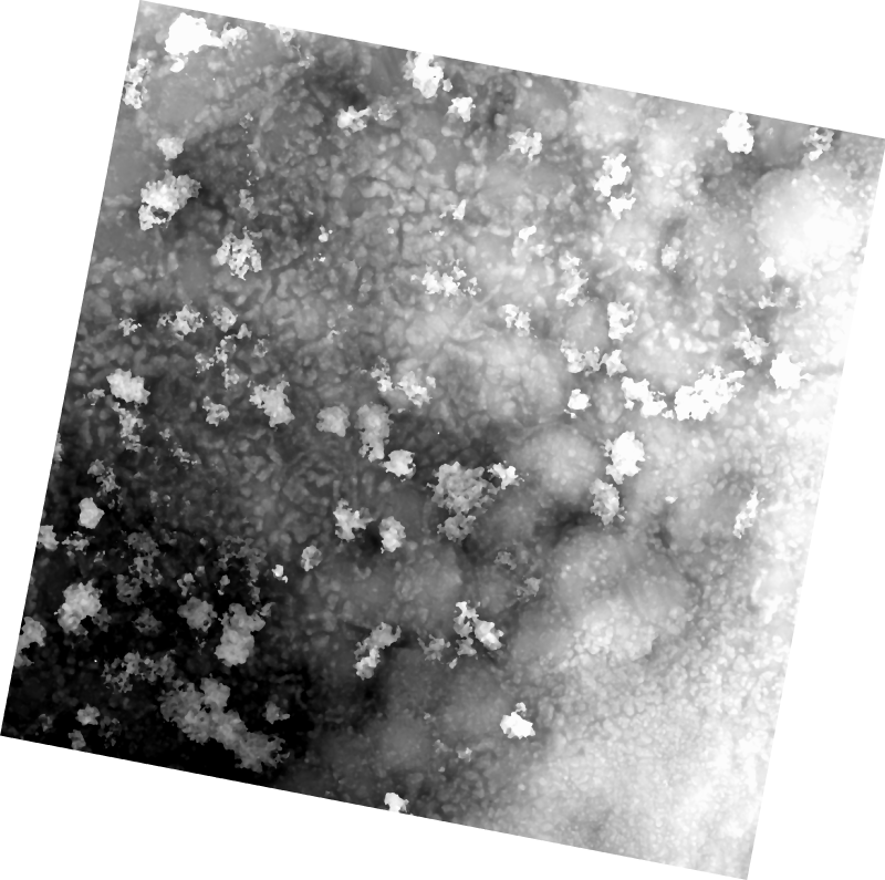
The 1 cm resolution vegetation digital height model was extracted using a bare earth model and digital surface model (DSM) derived from unmanned aerial vehicle (UAV) imagery acquired from a single day survey on July 28th 2016, in Cambridge Bay, Nunavut. The mapping product covers 525m2 and was produced by Canada Centre for Remote Sensing /Canada Centre for Mapping and Earth Observation. The UAV survey was completed in collaboration with the Canadian High Arctic Research Station (CHARS) for northern vegetation monitoring research. For more information, refer to our current Arctic vegetation research: Fraser et al; "UAV photogrammetry for mapping vegetation in the low-Arctic" Arctic Science, 2016, 2(3): 79-102. http://www.nrcresearchpress.com/doi/abs/10.1139/AS-2016-0008
-
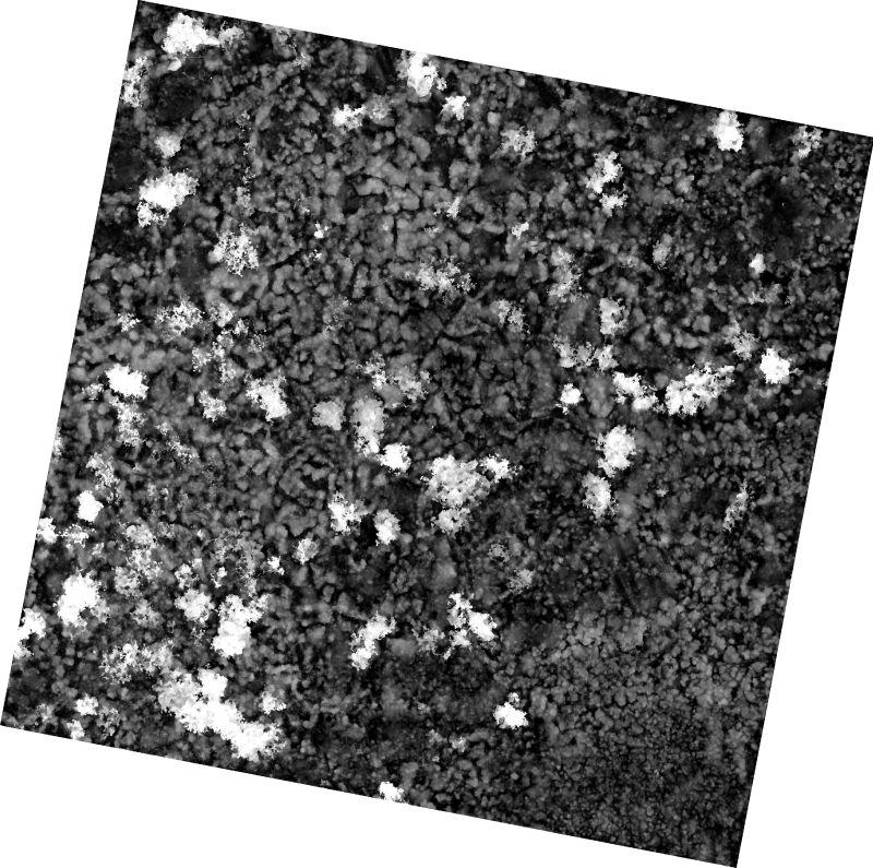
The 1 cm resolution digital surface model (DSM) was created from unmanned aerial vehicle (UAV) imagery acquired from a single day survey, July 28th 2016, in Cambridge Bay, Nunavut. Five control points taken from a Global Differential Positioning System were positioned in the corners and the center of the vegetation survey. The DSM covering 525m2 was produced by Canada Centre for Remote Sensing /Canada Centre for Mapping and Earth Observation. The UAV survey was completed in collaboration with the Canadian High Arctic Research Station (CHARS) for northern vegetation monitoring research. For more information, refer to our current Arctic vegetation research: Fraser et al; "UAV photogrammetry for mapping vegetation in the low-Arctic" Arctic Science, 2016, 2(3): 79-102. http://www.nrcresearchpress.com/doi/abs/10.1139/AS-2016-0008
-

In 2015, the Earth Observation Team of the Science and Technology Branch (STB) at Agriculture and Agri-Food Canada (AAFC) repeated the process of generating annual crop inventory digital maps using satellite imagery to for all of Canada, in support of a national crop inventory. A Decision Tree (DT) based methodology was applied using optical (Landsat-8) and radar (RADARSAT-2) based satellite images, and having a final spatial resolution of 30m. In conjunction with satellite acquisitions, ground-truth information was provided by provincial crop insurance companies and point observations from the BC Ministry of Agriculture and our regional AAFC colleagues.
-

This is a legacy product that is no longer supported. It may not meet current government standards. Canada3D is a digital elevation model (DEM) produced by the Canadian Forestry Service, Ontario region. The DEM consists of an ordered array of ground elevations providing coverage of the Canadian landmass. It has been derived from the cells of the Canadian Digital Elevation Data (CDED) at the 1:250 000 scale. Canada3D is available in two levels of detail: grids regularly spaced at 30 or 300 arc seconds. Canada3D 30 and 300 are recorded separately in ASCII format. The elevation values are expressed in metres with respect to mean sea level (MSL), in accordance with the North American Datum of 1983 (NAD83).
-
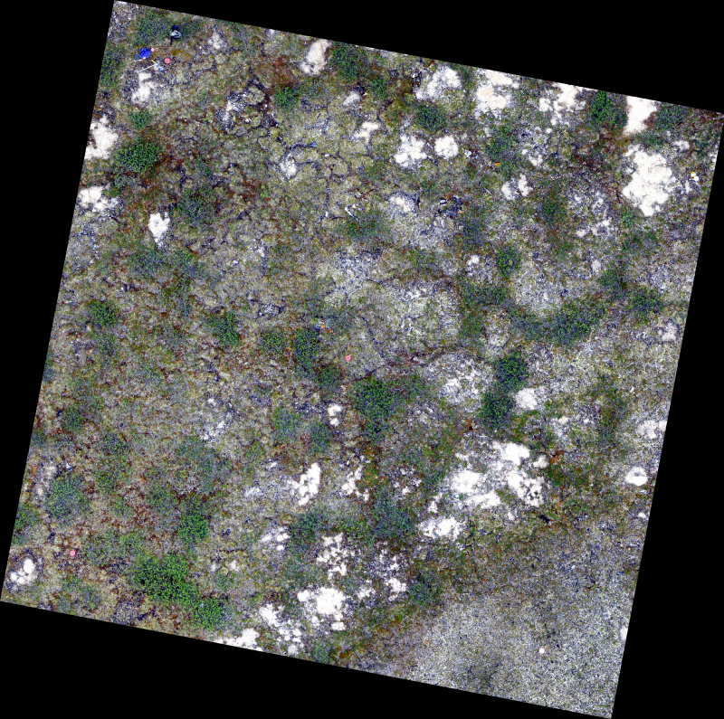
The 0.34 cm resolution orthomosaic was created from unmanned aerial vehicle (UAV) imagery acquired from a single day survey, July 28th 2016, in Cambridge Bay, Nunavut. Five control points taken from a Global Differential Positioning System were positioned in the corners and the center of the vegetation survey. The orthomosaic covering 525m2 was produced by Canada Centre for Remote Sensing /Canada Centre for Mapping and Earth Observation. The UAV survey was completed in collaboration with the Canadian High Arctic Research Station (CHARS) for northern vegetation monitoring research. For more information, refer to our current Arctic vegetation research: Fraser et al; "UAV photogrammetry for mapping vegetation in the low-Arctic" Arctic Science, 2016, 2(3): 79-102. http://www.nrcresearchpress.com/doi/abs/10.1139/AS-2016-0008.
-
Have you ever wanted to create your own maps, or integrate and visualize spatial datasets to examine changes in trends between locations and over time? Follow along with these training tutorials on QGIS, an open source geographic information system (GIS) and learn key concepts, procedures and skills for performing common GIS tasks – such as creating maps, as well as joining, overlaying and visualizing spatial datasets. These tutorials are geared towards new GIS users. We’ll start with foundational concepts, and build towards more advanced topics throughout – demonstrating how with a few relatively easy steps you can get quite a lot out of GIS. You can then extend these skills to datasets of thematic relevance to you in addressing tasks faced in your day-to-day work. Each tutorial video is also accompanied by a written script, providing a step-by-step reference that users can follow alongside the video or consult afterwards.
-

In July and August of 2019, a remotely piloted aircraft system (RPAS) project was undertaken in Canada’s western Arctic along the Inuvik to Tuktoyaktuk (ITH) and Dempster highways. The objective of this project was to test long-range RPAS missions for photogrammetric data acquisition and processing of these two Arctic highway corridors with embankments, bridges and culverts at risk of changing environmental and climatic regimes. The imagery was used to derive an orthomosaic and digital elevation model that could be used to measure road infrastructure and landscape change over time (e.g., fish habitat). The RPAS missions were conducted with a Griffon SeaHunter and full-frame DSLR sensor and scoped to obtain <10 cm spatial resolution imagery along a combined 396 linear km. The final deliverables covered over 22,000 ha and 29,000 ha for the ITH and Dempster Highways, respectively, and represent one of the first non-military beyond-visual-line-of-sight RPAS data products of its kind and scale in Canada, and likely elsewhere. At the time of collection the data constituted the most current and detailed photo surveys of two of Canada’s most northern highways constructed over ice-rich permafrost terrain, and will provide a valuable baseline to study past and future landscape change.
-

Mapping of neighborhoods in Quebec City.**This third party metadata element was translated using an automated translation tool (Amazon Translate).**
-

This collection is a legacy product that is no longer supported. It may not meet current government standards. This inventory presents chronologically the satellite images acquired, orthorectified and published over time by Natural Resources Canada. It is composed of imagery from the Landsat7 (1999-2003) and RADARSAT-1 (2001-2002) satellites, as well as the CanImage by-product and the control points used to process the images. Landsat7 Orthorectified Imagery: The orthoimage dataset is a complete set of cloud-free (less than 10%) orthoimages covering the Canadian landmass and created with the most accurate control data available at the time of creation. RADARSAT-1 Orthorectified Imagery: The 5 RADARSAT-1 images (processed and distributed by RADARSAT International (RSI) complete the landsat 7 orthoimagery coverage. They are stored as raster data produced from SAR Standard 7 (S7) beam mode with a pixel size of 15 m. They have been produced in accordance with NAD83 (North American Datum of 1983) using the Universal Transverse Mercator (UTM) projection. RADARSAT-1 orthoimagery were produced with the 1:250 000 Canadian Digital Elevation Data (CDED) and photogrammetric control points generated from the Aerial Survey Data Base (ASDB). CanImage -Landsat7 Orthoimages of Canada,1:50 000: CanImage is a raster image containing information from Landsat7 orthoimages that have been resampled and based on the National Topographic System (NTS) at the 1:50 000 scale in the UTM projection. The product is distributed in datasets in GeoTIFF format. The resolution of this product is 15 metres. Landsat7 Imagery Control Points: the control points were used for the geometric correction of Landsat7 satellite imagery. They can also be used to correct vector data and for simultaneously displaying data from several sources prepared at different scales or resolutions.