 Arctic SDI catalogue
Community infrastructures
Type of resources
Available actions
Topics
Keywords
Contact for the resource
Provided by
Formats
Representation types
Update frequencies
status
-
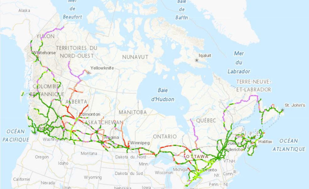
The Zero Emission Vehicle Infrastructure Program (ZEVIP) aims at addressing the lack of charging infrastructure in Canada, one of the key barriers to zero emission vehicle adoption by increasing the availability of localized charging where Canadians live, work, travel and play. This Planning Map for Public EV Charging Infrastructure identifies priority areas and accounts for available charging infrastructure and expected charging needs with a focus on public corridor charging. To optimize web performance when using the map, it is recommended you zoom into the areas you are exploring. Priority areas are identified on a scale ranging from lowest to highest priority. Public Corridor Charging includes the EV charging needs of those travelling longer distances on highways and major roads. The objective is to ensure that EV drivers can travel over the majority of Canada’s road network connecting most communities in an EV without being limited on vehicle range. The map identifies priority locations within 1.6 kilometres of major roads based on criteria such as, traffic, expected EV adoption and distance between chargers
-

The manmade features of the CanVec series include dams, protection structures (breakwater, dike/levees), liquid storage facilities (basin, swimming pool, etc.), tanks, buildings, delimiting structures (fence, walls, etc.), landmark features (cross, radar, crane, forts, etc.), chimneys, towers, sewage pipelines, conduit bridges, waste, leisure areas, residential areas, commercial and institutional areas and ritual cultural areas (shrine, cemeteries, etc.). The CanVec multiscale series is available as prepackaged downloadable files and by user-defined extent via a Geospatial data extraction tool. Related Products (Open Maps Links): [Topographic Data of Canada - CanVec Series](https://open.canada.ca/data/en/dataset/8ba2aa2a-7bb9-4448-b4d7-f164409fe056)
-

The Indigenous Community Infrastructure dataset depicts infrastructure projects across Canada that are supported by Indigenous Services Canada (ISC) targeted infrastructure funding. It contains data related to project category, description, status, departmental investment and community. The dataset allows the Department to pinpoint and share information about individual infrastructure projects in Indigenous communities, in a proactive and transparent manner, to: • Showcase where and how investments are carried out • Demonstrate the Government’s commitment to address socio-economic gaps between Indigenous and non-Indigenous communities in Canada and improve access to high-quality services Projects featured in this Indigenous Community Infrastructure dataset are updated on a quarterly basis. Because some projects will benefit more than one community, the number of projects does not match the number of markers on the map or of entries in the dataset. For more information, visit https://www.sac-isc.gc.ca/eng/1526995988708/1526996020578.