EBSA
Type of resources
Available actions
Topics
Keywords
Contact for the resource
Provided by
Formats
Representation types
Update frequencies
status
Scale
-
This geodatabase includes hotspot maps of 1) nearshore habitat richness, 2) diversity (fish and invertebrates), and 3) biomass (using catch per unit effort of fish and invertebrates), as well as two layers showing the spatial extent of the diversity and biomass hotspot analyses. Full details and methods can be found in the Rubidge et al. 2018 CSAS Research Document 2018/053 available here or at https://waves-vagues.dfo-mpo.gc.ca/Library/40759842.pdf. These data were reviewed as part of a Canadian Science Advisory Secretariat (CSAS) regional peer review process on Nov 1-2, 2017. Habitat Richness Hotspots: Because there are no systematic surveys of nearshore species that span the entire coastline of Northern Shelf Bioregion, the nearshore habitat richness hotspots were developed as a proxy for species diversity in nearshore areas. Habitat richness was calculated from eight habitat features: eelgrass, surfgrass, canopy-forming kelp, estuaries, areas of high rugosity, and hard, mixed, and soft substrate. The number of features within 1 km x 1 km planning units was counted, and hotspots were identified using the Getis-Ord G* tool in ArcGIS. Planning units with Gi_Bin values of 3 (99% confidence) were classified as habitat richness hotspots. Diversity and Biomass Hotspots: Hotspots of fish and invertebrate diversity and biomass were developed as proxies for spatial patterns of productivity in the Northern Shelf Bioregion. Diversity (Shannon diversity) and biomass (kg/hour or count/hook/hour) were calculated from DFO synoptic trawl and outside hard-bottom longline (HBLL) survey catch records. The outside HBLL survey was previously referred to as Pacific Halibut Management Area (PHMA) survey. The synoptic trawl and HBLL surveys have complementary spatial coverage, with the HBLL surveys occurring in more coastal areas (20–260 m) and the synoptic trawl surveys occurring on deeper shelf areas (50–1300 m). Hotspots were identified using the Getis-Ord G* tool in ArcGIS for five separate analyses: fish biomass (trawl), fish diversity (trawl), fish diversity (longline), invertebrate biomass (trawl), and invertebrate diversity (trawl). Using the Minimum Bounding Geometry Tool, convex hull polygons were drawn around groups of hotspot points (Gi_Bin values of 1, 2, or 3; confidence ≥90%) containing 10 or more points. The resulting polygons were then buffered by 1 km and manually edited where needed to exclude any large areas of the polygons that did not include hotspot points.
-
EBSAs (Source: CBD 2016) and marine “areas of heightened ecological and cultural significance” (Source: AMAP/CAFF/SDWG, 2013). In 2013, the Arctic Council identified “Areas of heightened ecological and cultural significance” using the International Maritime Organization criteria for Particularly Sensitive Sea Areas (PSSAs), which are similar to the CBD Ecologically and Biologically Significant Areas (EBSAs) criteria. The term “areas of heightened ecological and cultural significance” comes from Recommendation IIC of the Arctic Council’s 2009 Arctic Marine Shipping Assessment: ARCTIC PROTECTED AREAS - INDICATOR REPORT 2017
-
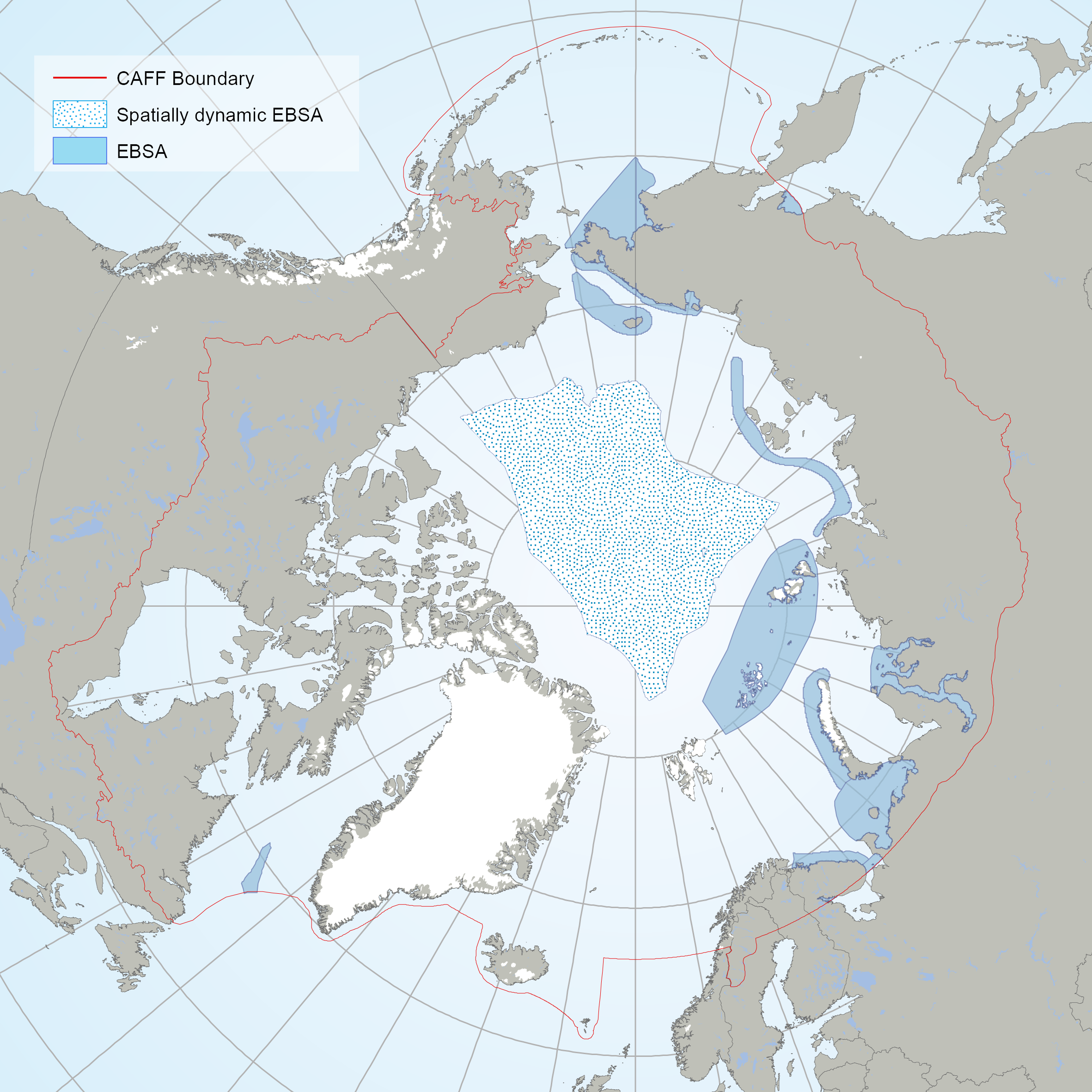
The EBSAs are special areas in the ocean that serve important purposes, in one way or another, to support the healthy functioning of oceans and the many services that it provides. The EBSAs contained din this dataset are the result of an Arctic Regional Workshop to Facilitate the Description of Ecologically or Biologically Significant Marine Areas (EBSAs) held in Finland on 3-7 march, 2014. <a href="https://www.cbd.int/ebsa/ebsas" target="_blank">Resource</a>
-
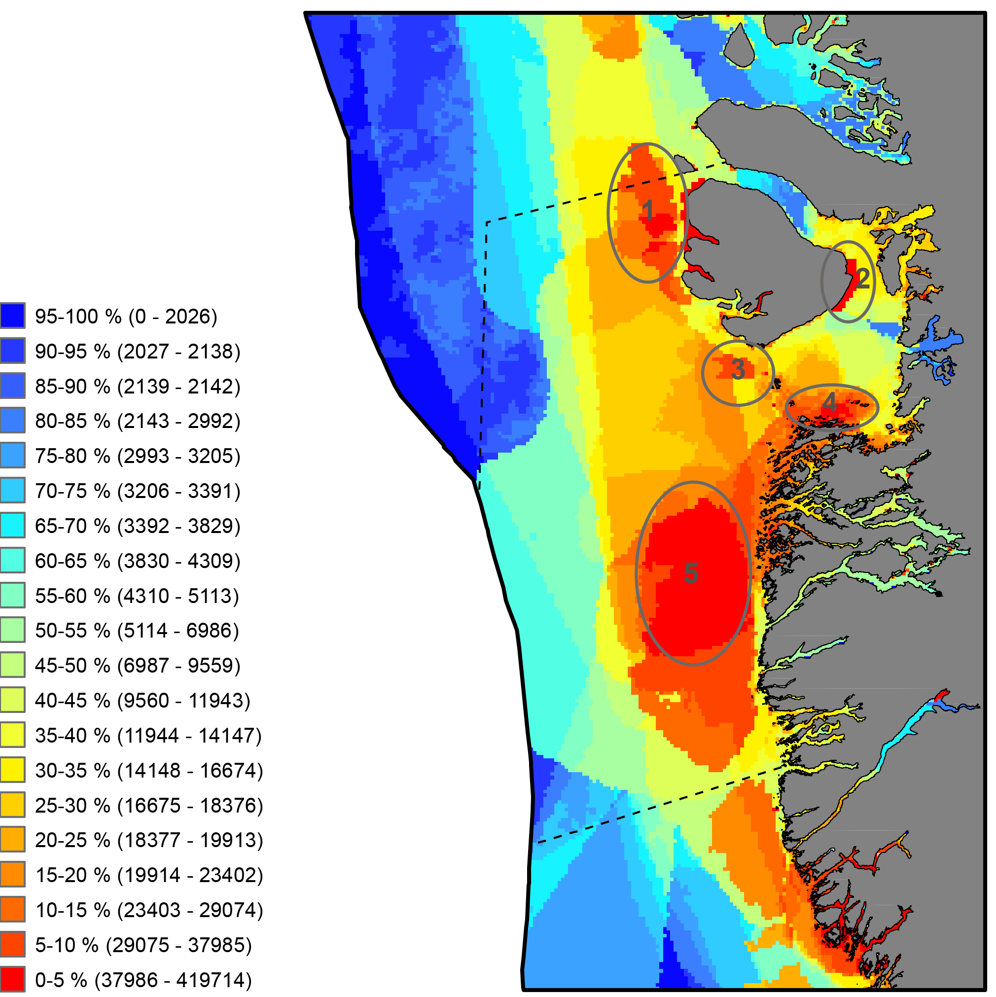
Critical to the successful implementation of EBM in the Arctic is the existence of a cohesive circumpolar approach to the collection and management of data and the application of compatible frameworks, standards and protocols that this entails. STATE OF THE ARCTIC MARINE BIODIVERSITY REPORT - <a href="https://arcticbiodiversity.is/marine" target="_blank">Chapter 2</a> - Page 29 - Box Figure 2.2
-

This layer details Important Areas (IAs) relevant to key vertebrate species, other than fish and cetaceans, in the West Coast Vancouver Island (WCVI) ecoregion. This data was mapped to inform the selection of marine Ecologically and Biologically Significant Areas (EBSA). Experts have indicated that these areas are relevant based upon their high ranking in one or more of three criteria (Uniqueness, Aggregation, and Fitness Consequences). The distribution of IAs within ecoregions is used in the designation of EBSAs. Canada’s Oceans Act provides the legislative framework for an integrated ecosystem approach to management in Canadian oceans, particularly in areas considered ecologically or biologically significant. DFO has developed general guidance for the identification of ecologically or biologically significant areas. The criteria for defining such areas include uniqueness, aggregation, fitness consequences, resilience, and naturalness. This science advisory process identifies proposed EBSAs in Canadian Pacific marine waters, specifically in the Strait of Georgia (SOG), along the west coast of Vancouver Island (WCVI, southern shelf ecoregion), and in the Pacific North Coast Integrated Management Area (PNCIMA, northern shelf ecoregion). Initial assessment of IAs in PNCIMA was carried out in September 2004 to March 2005 with spatial data collection coordinated by Cathryn Clarke. Subsequent efforts in WCVI and SOG were conducted in 2009, and may have used different scientific advisors, temporal extents, data, and assessment methods. WCVI and SOG IA assessment in some cases revisits data collected for PNCIMA, but should be treated as a separate effort. Other datasets in this series detail IAs for birds, cetaceans, coral and sponges, fish, geographic features, and invertebrates. Though data collection is considered complete, the emergence of significant new data may merit revisiting of IAs on a case by case basis.
-
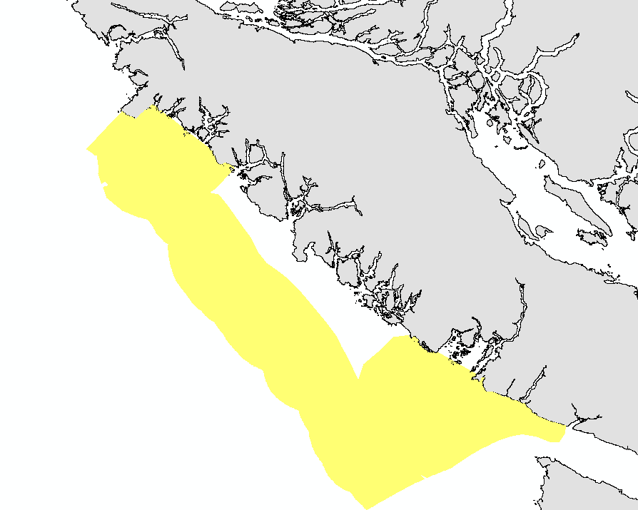
This layer details Important Areas (IAs) relevant to important geographic features in the West Coast Vancouver Island (WCVI) ecoregion. This data was mapped to inform the selection of marine Ecologically and Biologically Significant Areas (EBSA). Experts have indicated that these areas are relevant based upon their high ranking in one or more of three criteria (Uniqueness, Aggregation, and Fitness Consequences). Canada’s Oceans Act provides the legislative framework for an integrated ecosystem approach to management in Canadian oceans, particularly in areas considered ecologically or biologically significant. DFO has developed general guidance for the identification of ecologically or biologically significant areas. The criteria for defining such areas include uniqueness, aggregation, fitness consequences, resilience, and naturalness. This science advisory process identifies proposed EBSAs in Canadian Pacific marine waters, specifically in the Strait of Georgia (SOG), along the west coast of Vancouver Island (WCVI, southern shelf ecoregion), and in the Pacific North Coast Integrated Management Area (PNCIMA, northern shelf ecoregion). Initial assessment of IA's in PNCIMA was carried out in September 2004 to March 2005 with spatial data collection coordinated by Cathryn Clarke. Subsequent efforts in WCVI and SOG were conducted in 2009, and may have used different scientific advisors, temporal extents, data, and assessment methods. WCVI and SOG IA assessment in some cases revisits data collected for PNCIMA, but should be treated as a separate effort. Though data collection is considered complete, the emergence of significant new data may merit revisiting of IA's on a case by case basis. Other datasets in this series detail IAs for birds, cetaceans, fish, other vertebrates, corals and sponges, and other invertebrates. This package also includes project documentation and tech reports relevant to the IA process and its role within the selection of EBSAs.
-
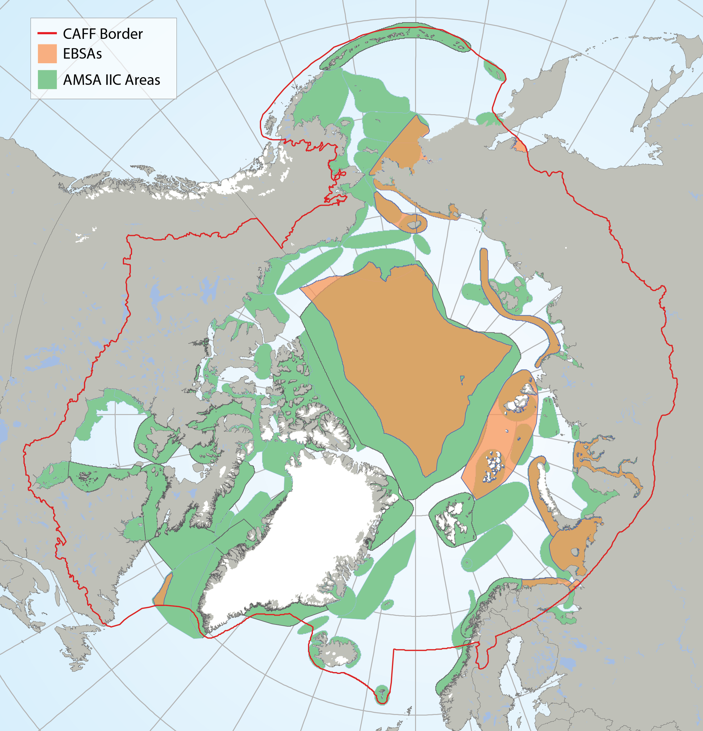
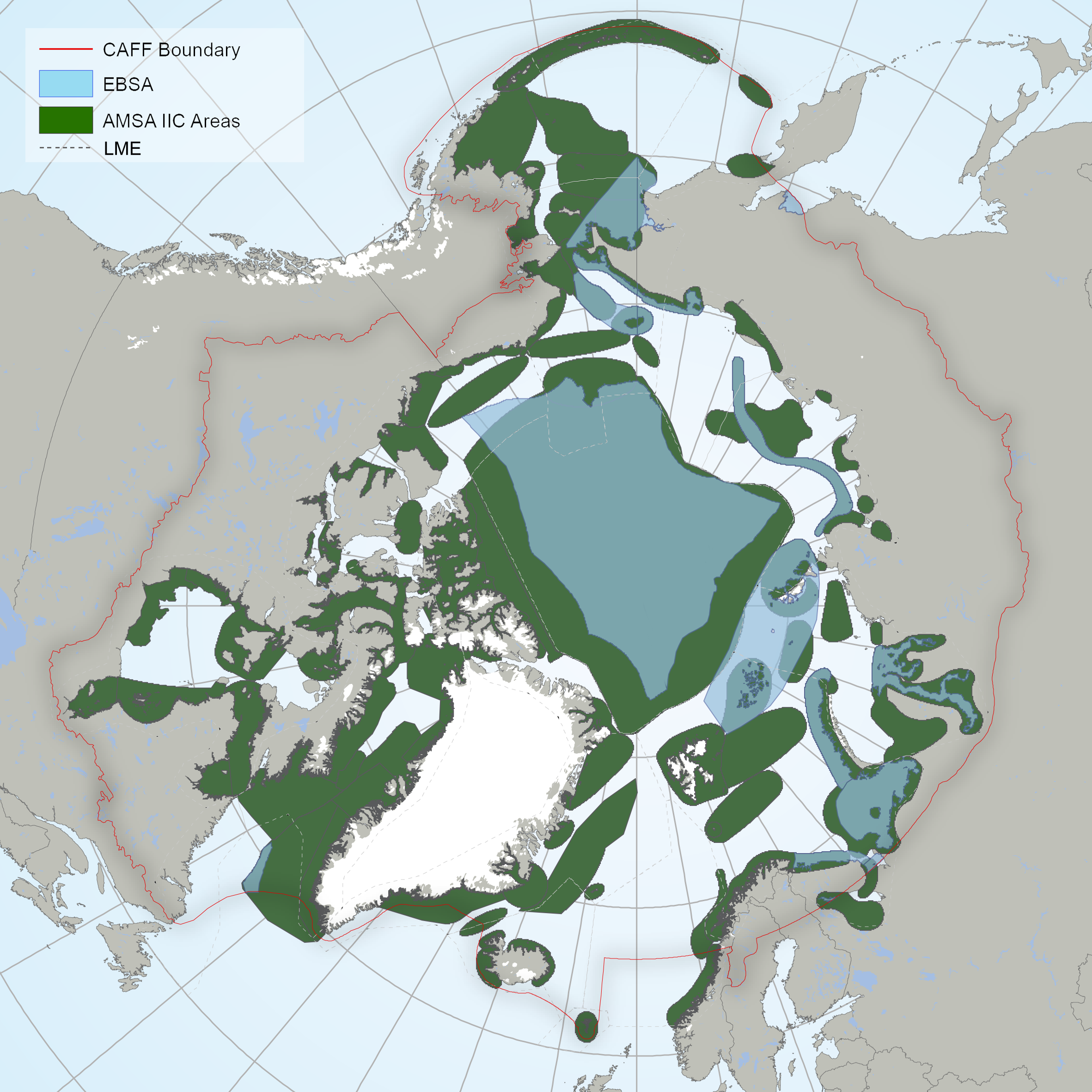
Arctic Ecologically and Biologically Significant Areas (EBSAs) and Arctic Marine Areas of Heightened Ecological and Cultural Significance as identified in the Arctic Marine Shipping Assessment (AMSA) IIC report. STATE OF THE ARCTIC MARINE BIODIVERSITY REPORT - <a href="https://arcticbiodiversity.is/marine" target="_blank">Chapter 1</a> - Page 16 - Box Figure 1.1
-

This layer details Important Areas (IAs) relevant to key cetacean species in the West Coast Vancouver Island (WCVI) ecoregion. This data was mapped to inform the selection of marine Ecologically and Biologically Significant Areas (EBSA). Experts have indicated that these areas are relevant based upon their high ranking in one or more of three criteria (Uniqueness, Aggregation, and Fitness Consequences). The distribution of IAs within ecoregions is used in the designation of EBSAs. Canada’s Oceans Act provides the legislative framework for an integrated ecosystem approach to management in Canadian oceans, particularly in areas considered ecologically or biologically significant. DFO has developed general guidance for the identification of ecologically or biologically significant areas. The criteria for defining such areas include uniqueness, aggregation, fitness consequences, resilience, and naturalness. This science advisory process identifies proposed EBSAs in Canadian Pacific marine waters, specifically in the Strait of Georgia (SOG), along the west coast of Vancouver Island (WCVI, southern shelf ecoregion), and in the Pacific North Coast Integrated Management Area (PNCIMA, northern shelf ecoregion). Initial assessment of IAs in PNCIMA was carried out in September 2004 to March 2005 with spatial data collection coordinated by Cathryn Clarke. Subsequent efforts in WCVI and SOG were conducted in 2009, and may have used different scientific advisors, temporal extents, data, and assessment methods. WCVI and SOG IA assessment in some cases revisits data collected for PNCIMA, but should be treated as a separate effort. Other datasets in this series detail IAs for birds, coral and sponges, fish, geographic features, invertebrates, and other vertebrates. Though data collection is considered complete, the emergence of significant new data may merit revisiting of IAs on a case by case basis.
-
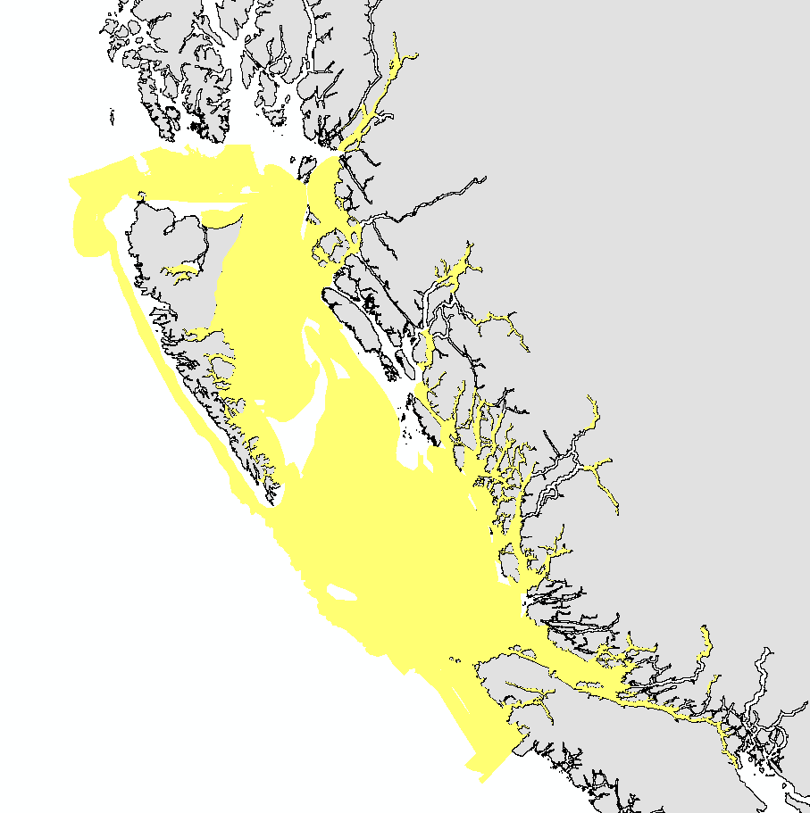
This layer details Important Areas (IAs) relevant to key fish species in the Pacific North Coast Integrated Management Area (PNCIMA). This data was mapped to inform the selection of marine Ecologically and Biologically Significant Areas (EBSA). Experts have indicated that these areas are relevant based upon their high ranking in one or more of three criteria (Uniqueness, Aggregation, and Fitness Consequences). The distribution of IAs within ecoregions is used in the designation of EBSAs. Canada’s Oceans Act provides the legislative framework for an integrated ecosystem approach to management in Canadian oceans, particularly in areas considered ecologically or biologically significant. DFO has developed general guidance for the identification of ecologically or biologically significant areas. The criteria for defining such areas include uniqueness, aggregation, fitness consequences, resilience, and naturalness. This science advisory process identifies proposed EBSAs in Canadian Pacific marine waters, specifically in the Strait of Georgia (SOG), along the west coast of Vancouver Island (WCVI, southern shelf ecoregion), and in the Pacific North Coast Integrated Management Area (PNCIMA, northern shelf ecoregion). Initial assessment of IA's in PNCIMA was carried out in September 2004 to March 2005 with spatial data collection coordinated by Cathryn Clarke. Subsequent efforts in WCVI and SOG were conducted in 2009, and may have used different scientific advisors, temporal extents, data, and assessment methods. WCVI and SOG IA assessment in some cases revisits data collected for PNCIMA, but should be treated as a separate effort. Other datasets in this series detail IAs for birds, cetaceans, coral and sponges, geographic features, invertebrates, and other vertebrates. Though data collection is considered complete, the emergence of significant new data may merit revisiting of IA's on a case by case basis. This package also includes project documentation and tech reports relevant to the IA process and its role within the selection of EBSAs.
-
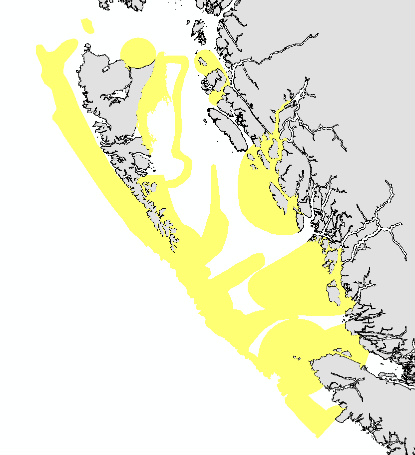
This layer details Important Areas (IAs) relevant to important geographic features in the Pacific North Coast Integrated Management Area (PNCIMA). This data was mapped to inform the selection of marine Ecologically and Biologically Significant Areas (EBSA). Experts have indicated that these areas are relevant based upon their high ranking in one or more of three criteria (Uniqueness, Aggregation, and Fitness Consequences). The distribution of IAs within ecoregions is used in the designation of EBSAs. Canada’s Oceans Act provides the legislative framework for an integrated ecosystem approach to management in Canadian oceans, particularly in areas considered ecologically or biologically significant. DFO has developed general guidance for the identification of ecologically or biologically significant areas. The criteria for defining such areas include uniqueness, aggregation, fitness consequences, resilience, and naturalness. This science advisory process identifies proposed EBSAs in Canadian Pacific marine waters, specifically in the Strait of Georgia (SOG), along the west coast of Vancouver Island (WCVI, southern shelf ecoregion), and in the Pacific North Coast Integrated Management Area (PNCIMA, northern shelf ecoregion). Initial assessment of IA's in PNCIMA was carried out in September 2004 to March 2005 with spatial data collection coordinated by Cathryn Clarke. Subsequent efforts in WCVI and SOG were conducted in 2009, and may have used different scientific advisors, temporal extents, data, and assessment methods. WCVI and SOG IA assessment in some cases revisits data collected for PNCIMA, but should be treated as a separate effort. Other datasets in this series detail IAs for birds, cetaceans, coral and sponges, fish, invertebrates, and other vertebrates. Though data collection is considered complete, the emergence of significant new data may merit revisiting of IA's on a case by case basis.
 Arctic SDI catalogue