 Arctic SDI catalogue
Lithology
Type of resources
Available actions
Topics
Keywords
Contact for the resource
Provided by
Years
Formats
Representation types
Update frequencies
status
Service types
Resolution
-
This service shows an overview of Sweden's bedrock and soils (meaning unconsolidated deposits) in the scale of 1:1M. The service contains layers showing bedrock lithology, dyke swarms, bedrock structures and unconsolidated deposits (mainly quaternary) covering the whole of Sweden. The information is complied from various surveys and existing maps throughout the country, and is a highly generalised product intended to give an overview on a national level.
-
Garrity, C.P., and Soller, D.R., in review, Geologic database of the Geologic Map of North America (v.1.0), adapted from Reed et al. (2005): U.S. Geological Survey Data Product, to be available on CDROM and WWW. [Source map is: Reed, J.C., Wheeler, J.O., and Tucholke, B.E., 2005, Geologic Map of North America, South Sheet, Geological Society of America Continent-Scale Map 001, scale 1:5000000, available at http://www.geosociety.org/bookstore/default.asp?oID=0&catID=12&pID=CSM001F]. Information on digital conversion of this map will, by late August, become available in technical paper by Garrity and Soller, at http://ngmdb.usgs.gov/Info/dmt/DMT07presentations.html. Preparation for OneGeology WMS by S.M. Richard (Arizona Geological Survey and U.S. Geological Survey), C.P. Garrity (USGS), D.C. Percy (Portland State University and U.S. Geological Survey), and D.R. Soller (USGS).
-
This service is a joint contribution by the geological surveys in Finland, Norway and Sweden to the OneGeology initiative. The Geological Map of Fennoscandian Shield outlines the main features of Finland's, Norway's and Sweden's bedrock geology. The map is composed of data resulting from several mapping campaigns, performed over decades and compiled and archived in digital format. Due to the variation of quality and scales of different mapping campaigns the level of accuracy in the underlying national database is variable. This service includes layers showing bedrock areas defined by lithology, dyke swarms and tectonic structures.
-

Prospectivity model highlights areas of Canada with the greatest potential for Mississippi Valley-type zinc deposits. The preferred prospectivity model is based on public geological, geochemical, and geophysical datasets that were spatially indexed using the H3 discrete global grid system. Each H3 cell is associated with a prospectivity value, or class probability, calculated from the best-performing gradient boosting machines model. Model results are filtered to include the top 20% of prospectivity values for visualization purposes.
-

Prospectivity model highlights areas of Canada with the greatest potential for magmatic nickel deposits. The preferred prospectivity model is based on public geological, geochemical, and geophysical datasets that were spatially indexed using the H3 discrete global grid system. Each H3 cell is associated with a prospectivity value, or class probability, calculated from the best-performing gradient boosting machines model. Model results are filtered to include the top 20% of prospectivity values for visualization purposes.
-

Prospectivity model highlights areas of Canada with the greatest potential for clastic-dominated zinc deposits. The preferred prospectivity model is based on public geological, geochemical, and geophysical datasets that were spatially indexed using the H3 discrete global grid system. Each H3 cell is associated with a prospectivity value, or class probability, calculated from the best-performing gradient boosting machines model. Model results are filtered to include the top 20% of prospectivity values for visualization purposes.
-
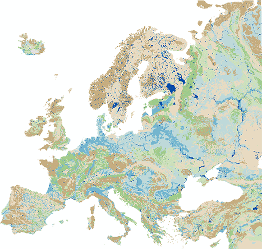
Die IHME1500 v1.2 ist ein durch Digitalisierung der 25 publizierten Kartenblätter der Internationalen Hydrogeologischen Karte von Europa im Maßstab 1:1.500.000 (IHME1500) entstandener Vektor-Datensatz. Dieser Datensatz wurde um fünf unpublizierte, ebenfalls digital erfasste IHME1500-Kartenblätter erweitert, um einen kompletten Blattschnitt zu erstellen. Der Datensatz besteht aus ausgewählten Fachthemen der IHME1500 mit folgenden Inhalten:- Aquifertypen (Flächen): Unterscheidung von sechs Typen hinsichtlich Produktivität und Hohlraumart der Grundwasserleiter.- Lithologie (Flächen): Lithologische Klassifizierung der Grundwasserleiter in fünf Aggregationsstufen.- Meerwasserintrusion (Flächen): Gebiete mit Versalzungserscheinungen im Grundwasser durch eindringendes Meerwasser.- Tektonische Störungen (Linien): Geologische Lineamente unterschieden in fünf Klassen mit gesicherten bzw. vermuteten Störungen und Überschiebungen und den Grenzen von Zerrüttungszonen auf Island. Die Vektordaten IHME1500 v1.2 beinhalten eine Bereinigung von Inkonsistenzen in den gedruckten Kartenblättern und wurden durch Anpassung an eine aktuelle topographische Grundlage einer Lagekorrektur unterzogen. Die IHME1500 ist ein Kartenwerk hydrogeologischer Übersichtskarten, das aus 25 publizierten Kartenblättern mit dazugehörigen Erläuterungen besteht und den gesamten europäischen Kontinent und Teile des Nahen Ostens abdeckt. Die federführenden Projektverantwortlichen sind die BGR und die UNESCO, unterstützt durch die Internationale Assoziation der Hydrogeologen (IAH) und die Kommission für die Geologische Weltkarte (CGMW). Die hydrogeologischen Inhalte basieren auf Beiträgen der jeweiligen abgebildeten Länder, die grenzüberschreitend abgestimmt wurden. Das Kartenwerk samt veröffentlichter Erläuterungshefte kann für wissenschaftliche Fragestellungen, für regionale Planungen und als Grundlage für detaillierte hydrogeologische Kartierarbeiten genutzt werden.
-

Description of the submarine morphology and characteristics of the sediments (lithology, grain size, mineralogy, and chemistry) of the Saguenay fjord, the lower Estuary and Gulf of St. Lawrence. The layer contains a synthesis of geological and geochemical data collected and interpreted over 10 years and is accompanied by detailed bathymetric and surface sediment maps. Most of this study deals with the geomorphology, surface sediments (lithology, mineralogy, and chemistry), and present depositional conditions, but several studies have also been made of the bedrock geology and the stratigraphy of the unconsolidated sediments. Purpose These studies are regional and of a reconnaissance nature in the sense that they have been designed to obtain acoustical and sampling data on the morphology and basic properties of the sediments from the whole Gulf. This approach was used to provide a broad appraisal of the sedimentary environment of the Gulf and its late-glacial and postglacial history. Additional Information Unknown date of numeric version. Acoustical and sampling data were obtained in the River and Gulf of St. Lawrence on board of different boats over the years. Sounding lines and sample stations were selected initially on the basis of submarine morphology and later in combination with a preliminary sedimentological map as the sea floor data accumulated. More specifically, acoustical data on the topography and nature of the sea floor was obtained from echosounding and continuous seismic profiling. Sounding records were studied, interpreted, and reduced manually in most cases to a scale suitable for plotting and presentation. The information on the continuous seismic records was first interpreted visually and the reduced to constant scale with the aid of a pantograph with independently vertical and horizontal scales. Also, about 1500 sediments samples have been collected from various parts of the Gulf to obtain a regional coverage of the sedimentary environment in the area. The sediment sample were sorted and split after their water content had been determined. Mineralogical analyses were carried out after separation into a heavy and light fraction. The light minerals were identified by a combined method of staining and the use of immersion liquids. For more details on consulted documents and their limit, see the following report: Loring, D. H., and D. J. G. Nota. 1973. Morphology and sediments of the Gulf of St. Lawrence. Bull. Fish. Res. Bd. Can. 182. 147 p. + 7 charts.
-

A predictive model for Canadian carbonatite-hosted REE ± Nb deposits is presented herein. This model was developed by integrating diverse data layers derived from geophysical, geochronological, and geological sources. These layers represent the key components of carbonatite-hosted REE ± Nb mineral systems, including the source, transport mechanisms, geological traps, and preservation processes. Deep learning algorithms were employed to integrate these layers into a comprehensive predictive framework. Here is a link to the publication that describes this product: https://link.springer.com/article/10.1007/s11053-024-10369-7
-

The Canada Geological Map Compilation (CGMC) is a database of previously published bedrock geological maps sourced from provincial, territorial, and other geological survey organizations. The geoscientific information included within these source geological maps wasstandardized, translated to English, and combined to provide complete coverage of Canada and support a range of down-stream machine learning applications. Detailed lithological, mineralogical, metamorphic, lithostratigraphic, and lithodemic information was not previously available as onenational-scale product. The source map data was also enhanced by correcting geometry errors and through the application of a new hierarchical generalized lithology classification scheme to subdivide the original rocks types into 35 classes. Each generalized lithology is associated with asemi-quantitative measure of classification uncertainty. Lithostratigraphic and lithodemic names included within the source maps were matched with the Lexicon of Canadian Geological Names (Weblex) wherever possible and natural language processing was used to transform all of the available text-basedinformation into word tokens. Overlapping map polygons and boundary artifacts across political boundaries were not addressed as part of this study. As a result, the CGMC is a patchwork of overlapping bedrock geological maps with varying scale (1:30,000-1:5,000,000), publication year (1996-2023), andreliability. Preferred geological and geochronological maps of Canada are presented as geospatial rasters based on the best available geoscientific information extracted from these overlapping polygons for each map pixel. New higher resolution geological maps will be added over time to fill datagaps and to update geoscientific information for future applications of the CGMC.