 Arctic SDI catalogue
Macroinvertebrates
Type of resources
Categories
Available actions
Topics
Keywords
Contact for the resource
Provided by
Formats
Representation types
Update frequencies
status
-
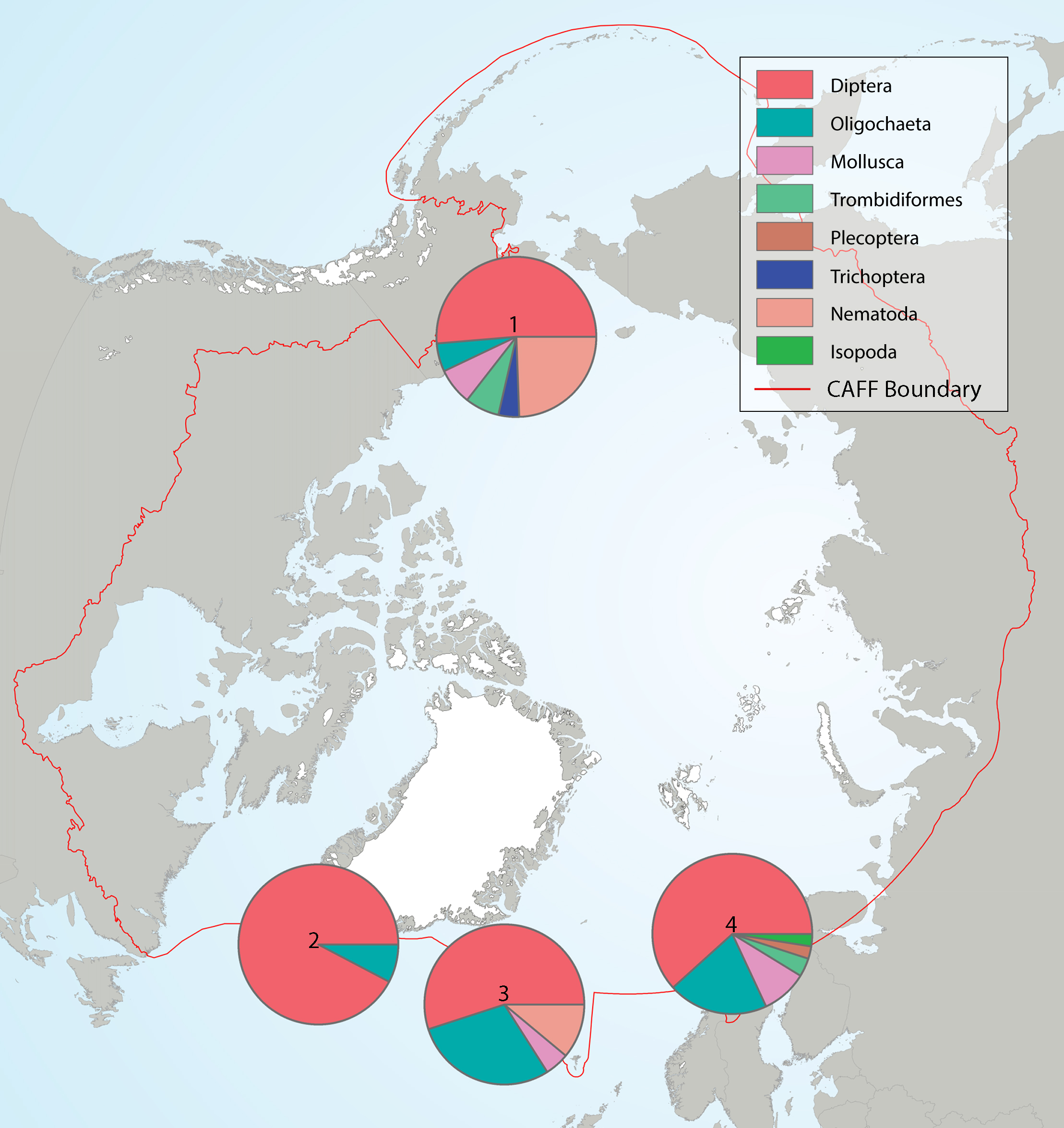
Summary of the taxa accounting for 85% of the lake littoral benthic macroinvertebrates collected in each of several highly-sampled geographic areas, with taxa grouped by order level or higher in pie charts placed spatially to indicate sampling area. Pie charts correspond to (1) Alaska, (2) Greenland low Arctic, (3) Iceland, and (4) Fennoscandia. State of the Arctic Freshwater Biodiversity Report - Chapter 4 - Page 69 - Figure 4-33
-
The objective of benthos monitoring is to know the state of benthic macroinvertebrate communities in rivers according, in particular, to the composition of the substrate and the type of flow. Information on benthic macroinvertebrate samples collected at benthos monitoring stations is classified according to the benthos health index: iSBG for coarse-substrate streams and iSBM for soft-substrate streams. The Benthos Health Index (ISB) is a multimetric index based on benthic macroinvertebrates that assesses the biotic integrity of shallow streams. The benthos monitoring dataset includes a layer of sampling stations sampled between 2003 and 2023 and a layer of drainage areas for each of the types of substrate, either coarse or loose. The drainage area attribute table also provides a compilation of land use by category for the last year available at the time of data production, i.e. the year 2020.**This third party metadata element was translated using an automated translation tool (Amazon Translate).**
-
The objective of the Canadian Wildlife Service (Ontario Region) Acid Rain Biomonitoring Program (ARBP) was to evaluate the response of biological communities in acidified, damaged and acid sensitive lakes and wetlands in response to regulation driven changes in deposition of acidifying pollutants. Supported by a research phase from 1981-1987, the biomonitoring program began in 1988 and ended in 2010. The program primarily focused on the small lakes and wetlands important to breeding aquatic birds, with many of the study lakes being headwaters or otherwise located in the upper reaches of watersheds. Beginning in the late 1980s, monitoring and studies focused on the Algoma (Block 12), Sudbury (Block 37) and Muskoka (Block 1) regions of Ontario. The Experimental Lakes Area (ELA; Block 24) was added as a fourth study area and was sampled in 2002 and 2009. The ARBP involved three main monitoring components. The water sampling component targeted approximately 250 to 350 lakes per year, with the schedule for Algoma, Sudbury and Muskoka aiming for a rotation such that a subset of lakes were sampled in adjacent years. Lakes were sampled near fall overturn using a helicopter on floats and water column samples were obtained from the deepest part of each sample lake. The breeding waterfowl survey targeted approximately 775 lakes (Algoma 242, Sudbury 176, Muskoka 250, ELA 107) with two study areas usually targeted each year. Surveys were done by helicopter equipped with bubble windows, a navigator/observer in front and two observers in the rear seats. Surveys were timed to target pairing and breeding initiation (typically May), with brood surveys (July) occurring in years of available human and financial resources. The food chain monitoring component targeted approximately 10 to 20 lakes in each study area, with a single study area usually targeted each year. Sampling was conducted by canoe in June and was designed to sample macroinvertebrates, amphibian larva, and small fish. The CWS-ON ARBP was conducted within a multidisciplinary program led by Environment Canada (currently Environment and Climate Change Canada). Under this program, federal and provincial scientists and academic researchers joined to advance the understanding, status reporting, and forecasting of the acid rain problem with respect to pollutant emissions, deposition, and effects on aquatic and terrestrial systems. Data from the CWS-ON ARBMP were analysed and reported in national Acid Deposition Science Assessments (1990, 1997, and 2004), science journals, and reports. Below is a list of documents providing additional information about the Acid Rain Biomonitoring Program (Canadian Wildlife Service, Ontario Region): 1. McNicol, D.K.; Mallory, M.L.; Sechley, J. 1998. Acid Rain and Wildlife: An Annotated Bibliography of Canadian Wildlife Service (Ontario Region) LRTAP Program Publications (1980 – 1997). Technical Report Series No. 305, Canadian Wildlife Service, Ontario Region. Available in English only: https://publications.gc.ca/collections/collection_2018/eccc/cw69-5/CW69-5-305-eng.pdf 2. Environment Canada. 2004. Canadian Acid Deposition Science Assessment. Available in English only: https://publications.gc.ca/collections/Collection/En4-46-2004E.pdf 3. McNicol, D.K.; Kerekes, J.J.; Mallory, M.L.; Ross, R. K.; Scheuhammer, A.M. 1995. The Canadian Wildlife Service LRTAP Biomonitoring Program, Part 1. A Strategy to Monitor the Biological Recovery of Aquatic Ecosystems in Eastern Canada from the Effects of Acid Rain. Technical Report Series No. 245, Canadian Wildlife Service, Ontario Region. Available in English only: https://publications.gc.ca/collections/collection_2018/eccc/cw69-5/CW69-5-245-eng.pdf 4. McNicoI, D.K.; Mallory, M.L.; Bendell, B.E. 1996. The Canadian Wildlife Service LRTAP Biomonitoring Program, Part 2. Food Chain Monitoring in Ontario Lakes: Taxonomic Codes and Collections. Technical Report Series No. 246, Canadian Wildlife Service, Ontario Region. Available in English only: https://publications.gc.ca/collections/collection_2018/eccc/cw69-5/CW69-5-246-eng.pdf 5. McNicoI, D.K.; Mallory, M.L.; Kerekes, J.J. 1996. The Canadian Wildlife Service LRTAP Biomonitoring Program, Part 3. Site locations, Physical, Chemical and Biological Characteristics. Technical Report Series No. 248, Canadian Wildlife Service, Ontario Region. Available in English only: https://publications.gc.ca/collections/collection_2018/eccc/cw69-5/CW69-5-248-eng.pdf