 Arctic SDI catalogue
Offshore Wind
Type of resources
Categories
Available actions
Topics
Keywords
Contact for the resource
Provided by
Formats
Representation types
Update frequencies
status
Scale
-

This dataset contains inputs and resultant data layers from the Preliminary Technical Resource Assessment for Offshore Wind in Canada’s Pacific Region completed by CanmetENERGY-Ottawa (CE O). The layers included in this dataset can be used to support early stage offshore wind planning and future decision making in the coastal waters of British Columbia. The analysis applied an exclusion based methodology to identify areas that met the assigned technical requirements for offshore wind developments for both fixed-bottom and floating offshore wind structures. Five technical constraints were assessed: water depth, annual average wind speed, distance from the coastline, seabed geology compatibility, and Marine Protected Areas (MPAs). These constraints were sequentially applied across the entirety of Canada’s Pacific offshore waters within the federal marine bioregions present on the west coast, covering approximately 454,000 km². For each scenario, areas that did not meet the defined technical thresholds were removed from the study area, resulting in spatial layers that delineate technically feasible offshore wind areas. This dataset represents only a technical assessment. It does not account for economic feasibility, regulatory approvals, Indigenous rights and interests, environmental sensitivities beyond MPAs, or other social and ecological considerations. The data are intended to inform future site specific studies, by initially identifying areas that merit further exploration to determine full suitability before decisions can be made on whether offshore wind will be deployed in the region. The link to the full report can be found here: https://doi.org/10.4095/g350288
-
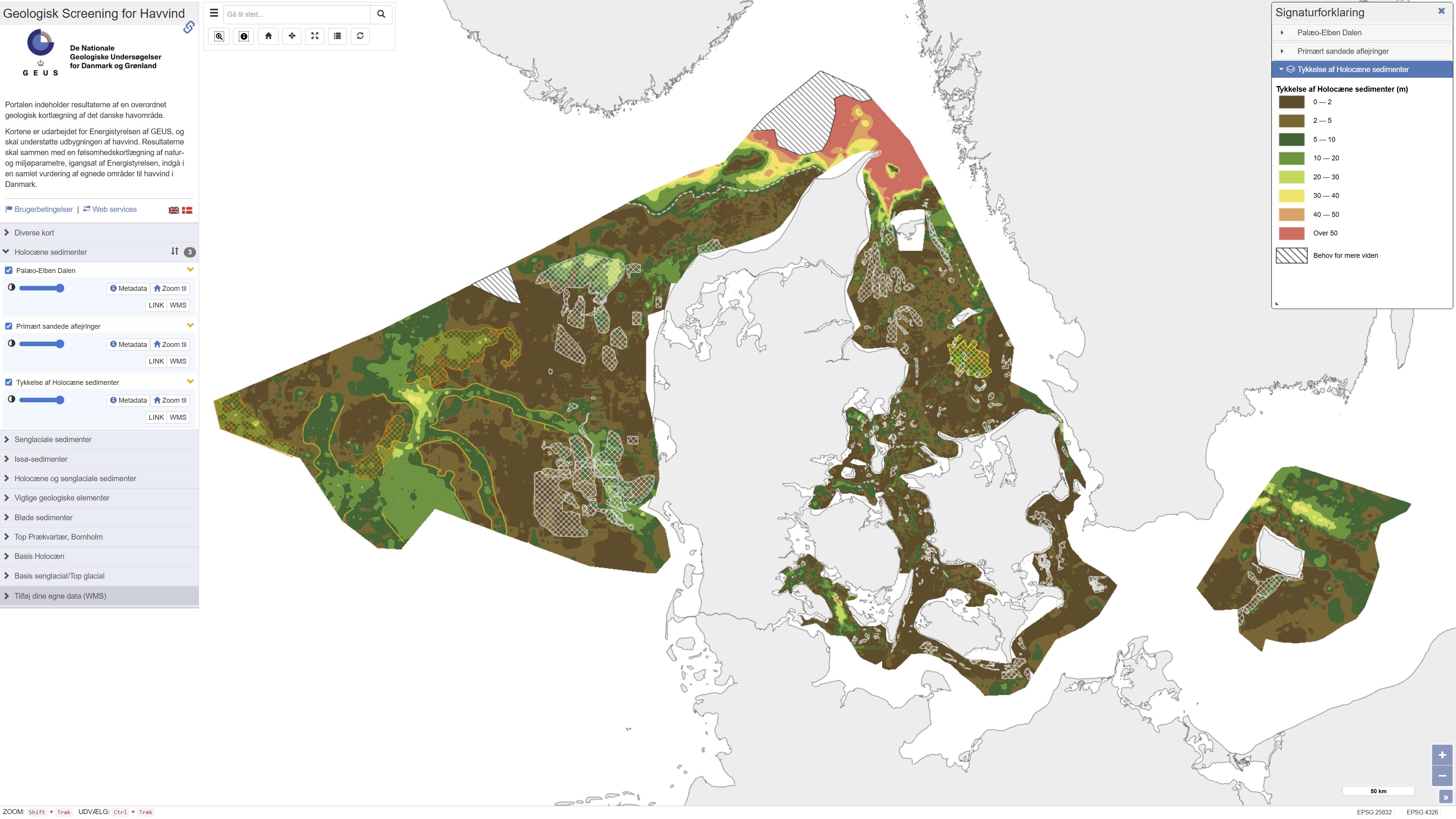
This repository contains maps of the thickness of late glacial and Holocene deposits in the Danish sea area, prepared as a basis for planning offshore wind. These are unconsolidated sediments that have not been overrun by the ice sheets of the ice ages, and therefore may have low geotechnical strength parameters. This is a large-scale and very general mapping, and no detailed interpretation of the distribution of sand and clay/mud/silt, respectively, has been made. In relation to the foundations of offshore wind turbines, sandy deposits will typically not pose a challenge, while soft deposits of clay, mud and silt in large thicknesses are assumed to pose foundation challenges. In addition to separate maps of the thickness of late glacial and Holocene deposits, a map of the total thickness of these two units has also been prepared, which thus constitutes a map of the total thickness of potentially soft sediments. Finally, the thickness of potentially soft sediments is used to divide the Danish sea area into categories in relation to the probability of larger thicknesses of soft sediments that could give rise to foundation challenges. Other maps are the thickness of potentially soft glacial lake sediments in the North Sea, the depth to the Pre-Quaternary surface in the waters around Bornholm, as well as the depth to the base of the Holocene deposits and the depth to the base of the late glacial deposits/top of the glacial deposits in the Danish sea area. As a supplement to the maps, a number of themes show where the late glacial and Holocene deposits are primarily expected to consist of sandy sediments. In addition, a number of themes show the Danish exclusive economic zone (EEZ), the location of conceptual geological models that can be seen in the overall report, all interpreted seismic lines, areas with near-surface gas in the sediments, interpreted distribution of the Palaeo-Elbe Valley in the North Sea, distribution of the Weichsel ice and ice-affected sediments in the North Sea, buried valleys (Prins & Andresen 2019; van der Vegt et al. 2012; Ottesen et al. 2020; Kirkham et al. 2024; Sandersen & Jørgensen 2016), structural elements (Al Hseinat & Hübscher 2017; Jensen et al. 2002), ice margin lines (Lange 1984; Kjær et al. 2003; Pedersen 2005; Phillips et al. 2018, 2022; Kirkham et al. 2024; Szuman et al. 2024; Pedersen & Boldreel 2017). The data basis for the work has primarily been new and existing near-surface seismic data and vibrocore drilling. The mapping was carried out for the Danish Energy Agency by GEUS, and is intended to support the development of offshore wind. The results, together with a sensitivity mapping of natural and environmental parameters, initiated by the Danish Energy Agency, are to be included in an overall assessment of suitable areas for offshore wind in Denmark.