 Arctic SDI catalogue
100000
Type of resources
Available actions
Topics
Keywords
Contact for the resource
Provided by
Years
Formats
Representation types
Update frequencies
status
Scale
Resolution
-

Corine Land Cover (CLC) 2012 and CLC change 2006-2012 are two of the datasets produced within the frame of the Initial Operations of the Copernicus programme (the European Earth monitoring programme previously known as GMES) on land monitoring.Corine Land Cover (CLC) provides consistent information on land cover and land cover changes across Europe. This inventory was initiated in 1985 (reference year 1990) and established a time series of land cover information with updates in 2000, 2006 and 2012 being the last one. CLC products are based on photointerpretation of satellite images by national teams of participating countries - the EEA member and cooperating countries – following a standard methodology and nomenclature with the following base parameters: 44 classes in the hierarchical three level Corine nomenclature; minimum mapping unit (MMU) for status layers is 25 hectares; minimum width of linear elements is 100 metres; minimum mapping unit (MMU) for Land Cover Changes (LCC) for the change layers is 5 hectares. The resulting national land cover inventories are further integrated into a seamless land cover map of Europe. Land cover and land use (LCLU) information is important not only for land change research, but also more broadly for the monitoring of environmental change, policy support, the creation of environmental indicators and reporting. CLC datasets provide important datasets supporting the implementation of key priority areas of the Environment Action Programmes of the European Union as protecting ecosystems, halting the loss of biological diversity, tracking the impacts of climate change, assessing developments in agriculture and implementing the EU Water Framework Directive, among others.More about the Corine Land Cover (CLC) and Copernicus land monitoring data in general can be found at http://land.copernicus.eu/.
-

The Corine Land Cover datasets CLC2000, CLC2006and CLC change 2000-2006areproduced within the frame of the GMES land monitoringproject.Corine Land Cover (CLC) provides consistent information on land cover and land cover changes across Europe. This inventory was initiated in 1985 (reference year 1990) and established a time series of land cover information with updates in 2000 and 2006.CLC products are based on photointerpretation of satellite images by national teams of participating countries - the EEA member and cooperating countries – following a standard methodology and nomenclature with the following base parameters: 44 classes in the hierarchical three level Corine nomenclature; minimum mapping unit (MMU) for status layers is 25 hectares; minimum width of linear elements is 100 metres; minimum mapping unit (MMU) for Land Cover Changes (LCC) for the change layers is 5 hectares. The resulting national land cover inventories are further integrated into a seamless land cover map of Europe.Land cover and land use (LCLU) information is important not only for land change research, but also more broadly for the monitoring of environmental change, policy support, the creation of environmental indicators and reporting. CLC datasets provide important datasets supporting the implementation of key priority areas of the Environment Action Programmes of the European Union as protecting ecosystems, halting the loss of biological diversity, tracking the impacts of climate change, assessing developments in agriculture and implementing the EU Water Framework Directive, among others.More about the Corine Land Cover (CLC) and Copernicus land monitoring data in general can be found at http://land.copernicus.eu/.
-
Land Cover (LC) is one of 12 themes in the European Location Project (ELF). The purpose of ELF is to create harmonised cross-border, cross-theme, and cross-resolution pan-European reference data from national contributions. The goal is to provide INSPIRE-compliant data for Europe. A description of ELF (European Location Project) is here: http://www.elfproject.eu/content/overview. Encoding: INSPIRE version 4
-

EuroBoundaryMap is a seamless geo-database at the scale 1:100 000 covering 55 countries. It contains geometry, names and codes of administrative and statistical units continuously updated by the members of EuroGeographics, the national mapping and cadastral authorities (NMCAs) of Europe. Updated annually. Datasets in EBM: The EBM dataset was derived from the Icelandic National Database IS 50V, which is at the scale 1:50.000. The generalization has been applied in form of smooth polygon and simplify polygon that ensured the required resolution of the data for the EBM 1: 100 000 scale. The topological relations of the line and area features were ensured. Administrative Units includes: AdministrativeBoundary a line layer containing the demarcations outlining administrative units. AdministrativeUnit_1 a polygon layer containing the national administrative hierarchy, Level 1 (republic). AdministrativeUnit_2 a polygon layer containing the national administrative hierarchy, Level 2 (municipalities). Residence of Authority a point layer containing the administrative centres of all administrative levels. BasicGeometry includes: EBM_A a polygon layer containing administrative areas. Here are the basic components on which administrative units of all hierarchical levels, as well as all statistical layers, are composed. EBM_P a point layer meant for labelling purposes. Label points are located within the main area of the administrative units on lowest level. StatisticalUnits includes: LAU a polygon layer = Local Administrative Unit. NUTS_1 a polygon layer = Nomenclature of Territorial Units for Statistics (whole country) NUTS_2 a polygon layer NUTS_3 a polygon layer = Nomenclature of Territorial Units for Statistics (capital area, rural areas) Tables in EBM: CountryCodes = all countries have unique country codes (icc). EBM_CHR = country codes of those countries where the language is used in alphabetical order delimited by #. EBM_coAdministered = Relationship between administrative unit and its co-administering administrative units on the same hierarchical level. A few countries have special areas with shared administrative units. EBM_ISN = designations of administrative hierarchical levels EBM_NAM = names of administrative units EBM_NUTS = Relationship between the SHN codes of administrative units on lowest national administrative level and corresponding statistical codes.
-

ELF Protected Sites (PS) is one of 12 themes in the European Location Project (ELF). The purpose of ELF is to create harmonised cross-border, cross-theme and cross-resolution pan-European reference data from national contributions. The goal is to provide INSPIRE-compliant data for Europe. A description of the ELF (European Location Project) is here: http://www.elfproject.eu/content/overview. Encoding: INSPIRE version 4
-

The Corine Land Cover datasets CLC2000, CLC2006 and CLC change 2000-2006 areproduced within the frame of the GMES land monitoring project. Corine Land Cover (CLC) provides consistent information on land cover and land cover changes across Europe. This inventory was initiated in 1985 (reference year 1990) and established a time series of land cover information with updates in 2000 and 2006.CLC products are based on photointerpretation of satellite images by national teams of participating countries - the EEA member and cooperating countries – following a standard methodology and nomenclature with the following base parameters: 44 classes in the hierarchical three level Corine nomenclature; minimum mapping unit (MMU) for status layers is 25 hectares; minimum width of linear elements is 100 metres; minimum mapping unit (MMU) for Land Cover Changes (LCC) for the change layers is 5 hectares. The resulting national land cover inventories are further integrated into a seamless land cover map of Europe.Land cover and land use (LCLU) information is important not only for land change research, but also more broadly for the monitoring of environmental change, policy support, the creation of environmental indicators and reporting. CLC datasets provide important datasets supporting the implementation of key priority areas of the Environment Action Programmes of the European Union as protecting ecosystems, halting the loss of biological diversity, tracking the impacts of climate change, assessing developments in agriculture and implementing the EU Water Framework Directive, among others.More about the Corine Land Cover (CLC) and Copernicus land monitoring data in general can be found at http://land.copernicus.eu/.
-

The Corine Land Cover datasets CLC2000, CLC2006and CLC change 2000-2006 are produced within the frame of the GMES land monitoringproject.Corine Land Cover (CLC) provides consistent information on land cover and land cover changes across Europe. This inventory was initiated in 1985 (reference year 1990) and established a time series of land cover information with updates in 2000 and 2006.CLC products are based on photointerpretation of satellite images by national teams of participating countries - the EEA member and cooperating countries – following a standard methodology and nomenclature with the following base parameters: 44 classes in the hierarchical three level Corine nomenclature; minimum mapping unit (MMU) for status layers is 25 hectares; minimum width of linear elements is 100 metres; minimum mapping unit (MMU) for Land Cover Changes (LCC) for the change layers is 5 hectares. The resulting national land cover inventories are further integrated into a seamless land cover map of Europe.Land cover and land use (LCLU) information is important not only for land change research, but also more broadly for the monitoring of environmental change, policy support, the creation of environmental indicators and reporting. CLC datasets provide important datasets supporting the implementation of key priority areas of the Environment Action Programmes of the European Union as protecting ecosystems, halting the loss of biological diversity, tracking the impacts of climate change, assessing developments in agriculture and implementing the EU Water Framework Directive, among others.More about the Corine Land Cover (CLC) and Copernicus land monitoring data in general can be found at http://land.copernicus.eu/.
-
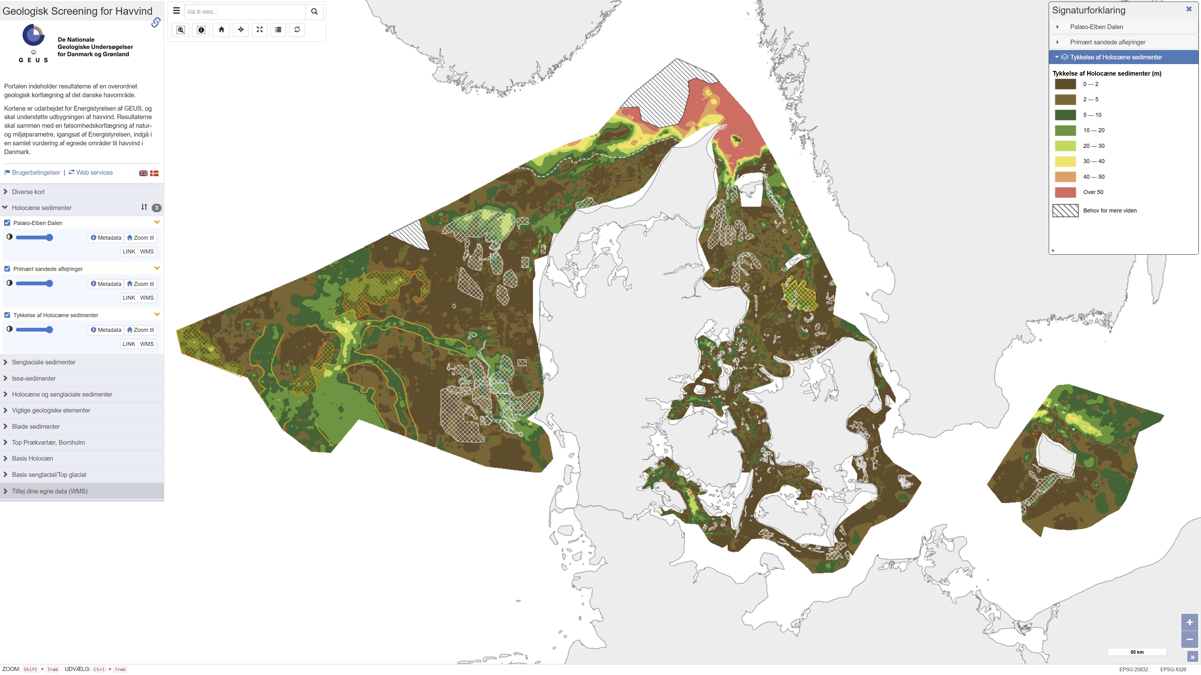
This repository contains maps of the thickness of late glacial and Holocene deposits in the Danish sea area, prepared as a basis for planning offshore wind. These are unconsolidated sediments that have not been overrun by the ice sheets of the ice ages, and therefore may have low geotechnical strength parameters. This is a large-scale and very general mapping, and no detailed interpretation of the distribution of sand and clay/mud/silt, respectively, has been made. In relation to the foundations of offshore wind turbines, sandy deposits will typically not pose a challenge, while soft deposits of clay, mud and silt in large thicknesses are assumed to pose foundation challenges. In addition to separate maps of the thickness of late glacial and Holocene deposits, a map of the total thickness of these two units has also been prepared, which thus constitutes a map of the total thickness of potentially soft sediments. Finally, the thickness of potentially soft sediments is used to divide the Danish sea area into categories in relation to the probability of larger thicknesses of soft sediments that could give rise to foundation challenges. Other maps are the thickness of potentially soft glacial lake sediments in the North Sea, the depth to the Pre-Quaternary surface in the waters around Bornholm, as well as the depth to the base of the Holocene deposits and the depth to the base of the late glacial deposits/top of the glacial deposits in the Danish sea area. As a supplement to the maps, a number of themes show where the late glacial and Holocene deposits are primarily expected to consist of sandy sediments. In addition, a number of themes show the Danish exclusive economic zone (EEZ), the location of conceptual geological models that can be seen in the overall report, all interpreted seismic lines, areas with near-surface gas in the sediments, interpreted distribution of the Palaeo-Elbe Valley in the North Sea, distribution of the Weichsel ice and ice-affected sediments in the North Sea, buried valleys (Prins & Andresen 2019; van der Vegt et al. 2012; Ottesen et al. 2020; Kirkham et al. 2024; Sandersen & Jørgensen 2016), structural elements (Al Hseinat & Hübscher 2017; Jensen et al. 2002), ice margin lines (Lange 1984; Kjær et al. 2003; Pedersen 2005; Phillips et al. 2018, 2022; Kirkham et al. 2024; Szuman et al. 2024; Pedersen & Boldreel 2017). The data basis for the work has primarily been new and existing near-surface seismic data and vibrocore drilling. The mapping was carried out for the Danish Energy Agency by GEUS, and is intended to support the development of offshore wind. The results, together with a sensitivity mapping of natural and environmental parameters, initiated by the Danish Energy Agency, are to be included in an overall assessment of suitable areas for offshore wind in Denmark.
-
%20-%20datas%C3%A6t.jpg)
The exclusive economic zone in the North Sea, Skagerrak, Kattegat, Øresund, Storebælt and the Baltic Sea comprises sea areas outside and adjacent to the territorial sea up to a distance of 200 nautical miles from the baselines in force at any time. With regard to the course of the baselines, reference is made to the executive order on the delimitation of Denmark's territorial sea in force at any time. The border is covered by Executive Order No. 1662 of 17/11/2020 https://www.retsinformation.dk/eli/lta/2020/1662.
-
Þekja [layer] j100v_vesturgosbelti_lindir_1utg_p: Lindir og hverir á Vesturgosbelti Íslands. [Springs and hotsprings of the Western Volcanic Zone of Iceland.] Gögnin sýna laug, hver, lindir, gufu- og leirhver. Gögn eru ekki flokkuð eftir ÍST120:2012 staðlinum. Hér er flokkun eða lýsing nýrra fitjueiginda: 'tegUppsprettuISOR': 2: 10–25°C (Laug) 3: 25–50°C (Laug) 4: 50–75°C (Laug) 5: 75–98°C (Laug) 6: 98–100°C (Hver) 20: Hrúður 30: Leir- og gufuhverir 7212: Lindir 10–100 l/s 7213: Lindir >100 l/s 7214: Lindasvæði 100–1000 l/s 7215: Lindasvæði >1000 l/s 'tegUppsprettuNI': 1: Lindir 4: Laug (10–98°C) 5: Hver (98–100°C) 6: Leir- og gufuhver 'vatnshiti': Hitastig vatnsins við lindina, mælieining: °C. 'gerdiISOR': Grágrýtislind/Grágrýtislindir: Lind/lindir í hrauni eldra en síðasta jökulskeið, Hraunalind/Hraunalindir: Lind/lindir í nútímahrauni, Móbergslind/Móbergslindir: Lind/lindir í móbergi, Sprungulind: Lind í sprungu. [This data includes cold, warm and hot springs, steam and mud springs. The data does not follow the ÍST120:2012 data standard. Explanation and classification of the new feature attributes: 'tegUppsprettuISOR': 2: 10–25°C (Warm spring) 3: 25–50°C (Warm spring) 4: 50–75°C (Warm spring) 5: 75–98°C (Warm spring) 6: 98–100°C (Boiling spring) 20: Hot spring deposits 30: Mud and steam spring 7212: Cold spring 10–100 l/s 7213: Cold spring >100 l/s 7214: Cold spring area 100–1000 l/s 7215: Cold spring area >1000 l/s 'tegUppsprettuNI': 1: Cold spring 4: Warm spring (10–98°C) 5: Boiling spring (98–100°C) 6: Mud and steam spring 'vatnshiti': Temperature of the spring in °C. 'gerdiISOR': Grágrýtislind/Grágrýtislindir: Spring(s) in 'grey basalt' lavas older than the last glacial, Hraunalind/Hraunalindir: Spring(s) in postglacial lavas, Móbergslind/Móbergslindir: Spring(s) in hyaloclastite tuff, Sprungulind: Spring in tectonic fissure.]