 Arctic SDI catalogue
Protected
Type of resources
Available actions
Topics
Keywords
Contact for the resource
Provided by
Formats
Representation types
Update frequencies
status
-
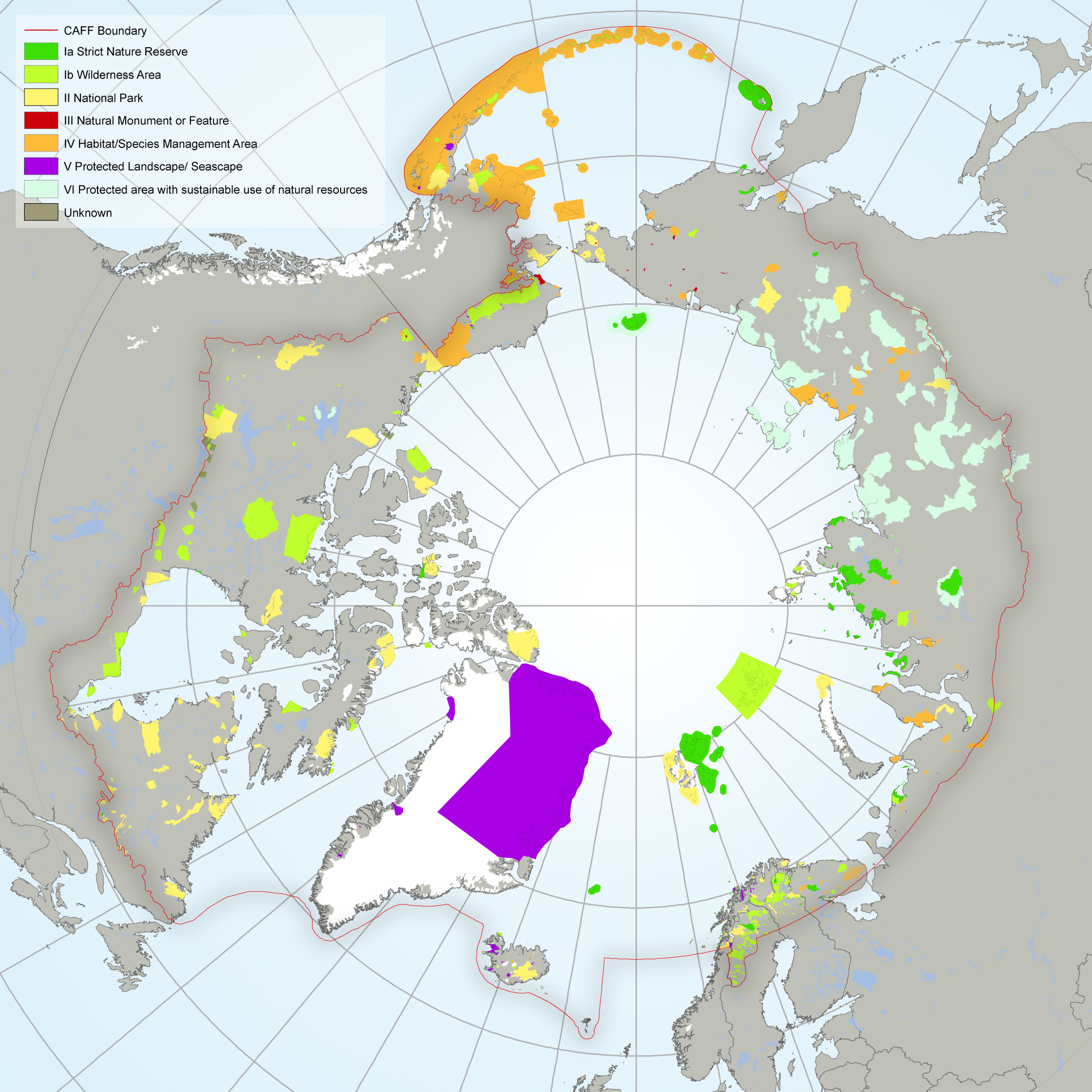
The Conservation of Arctic Flora and Fauna (CAFF) and Protection of the Arctic Marine Environments (PAME) working groups of the Arctic Council developed this indicator report. It provides an overview of the status and trends of protected areas in the Arctic. The data used represents the results of the 2016 update to the Protected Areas Database submitted by each of the Arctic Council member states (Annex 1). This report uses the International Union for the Conservation of Nature (IUCN) definition for protected areas (see Box 1) which includes a wide range of Management Categories – from strict nature reserve to protection with sustainable use. Consequently, the level of protection and governance of these areas varies throughout the circumpolar region and its countries.
-

This layer is the authoritative source for locating Active Status Growth and Yield plots also known as Permanent Sample Plots (PSPs). These plots are protected and require an additional minimum windfirm buffer of 50m radius in the interior and 100m radius on the coast. These plots are generally 16m radius fixed area plots. Therefore, protected areas need to be a minimum of 66m radius around the plot centre in the interior and 116m radius on the coast. Best practices are to locate the plot centre on the ground as coordinate accuracy varies. The program now maintains partially damaged plots in order to provide critical data on how partially damaged plots grow over time. Therefore, salvage logging is NOT permitted within protected plots. Please contact Anya Reid (Anya.Reid@gov.bc.ca) with questions or updated coordinates for plots. NOTE: Accuracy of the coordinates are variable. Coordinates for plots with a more recent (since 2000) last measurement are generally quite accurate (3m). However, plots measured in the 1990's have a wide range of coordinate accuracy. In all cases, it is necessary to ground truth plot location before block layout. In this spatial layer, low accuracy coordinates are buffered 300m to ensure they do not get missed from development planning. This layer replaces the [Growth and Yield Samples – Active Status](https://catalogue.data.gov.bc.ca/dataset/0ca49478-5d0f-44e8-b6af-3fd6e387803c) layer with more accurate and current information from the Inventory Sample Management Consolidation (ISMC) database.
-

Tile layer of protected, managed forest code 20 used in the Story Map of Forest Management in Canada, 2017. Tile layer of protected, managed forest code 20 used in the Story Map of Forest Management in Canada, 2017. Protected areas were identified using the Canadian Council on Ecological Areas CARTS geodatabase. All IUCN Category Ia through VI protected areas in Canada were classified as Protected (CCEA 2008) with only a few exceptions. Data provided by Alberta Agriculture and Forestry; British Columbia Ministry of Forests; Manitoba Sustainable Development; Natural Resources Canada; New Brunswick Department of Energy and Resource Development; Newfoundland & Labrador Department of Fisheries and Land Resources; Northwest Territories Department of Environment and Natural Resources; Nova Scotia Department of Lands and Forestry; Ontario Ministry of Natural Resources and Forestry; Prince Edward Island Department of Communities, Land & Environment; Québec Ministère des Forêts, de la Faune et des Parcs; Saskatchewan Ministry of Environment; and Yukon Energy, Mines and Resources.
-
Protected map (managed forest code 20) used in the Story Map of Forest Management in Canada, 2017. Protected map (managed forest code 20) used in the Story Map of Forest Management in Canada, 2017. Protected areas were identified using the Canadian Council on Ecological Areas CARTS geodatabase. All IUCN Category Ia through VI protected areas in Canada were classified as Protected (CCEA 2008) with only a few exceptions. Source: This web map shows the protected areas used in the map of forest management in Canada, 2017 and includes the following tiled layer:Protected (Managed Forest Code 20) Data provided by Alberta Agriculture and Forestry; British Columbia Ministry of Forests; Manitoba Sustainable Development; Natural Resources Canada; New Brunswick Department of Energy and Resource Development; Newfoundland & Labrador Department of Fisheries and Land Resources; Northwest Territories Department of Environment and Natural Resources; Nova Scotia Department of Lands and Forestry; Ontario Ministry of Natural Resources and Forestry; Prince Edward Island Department of Communities, Land & Environment; Québec Ministère des Forêts, de la Faune et des Parcs; Saskatchewan Ministry of Environment; and Yukon Energy, Mines and Resources.
-
Protected map (managed forest code 20) used in the Forest Management in Canada, 2020 story map. Protected map (managed forest code 20) created from protected areas within the Canadian Protected and Conserved Areas database. The protected map is used in the Story Map of Forest Management in Canada, 2020 (Aménagement des forêts au Canada, 2020) and includes the following tiled layer: Tile Layer of Protected Managed Forest Code 20: 2020
-
Indian Reserve map (managed forest code 32) used in the Forest Management in Canada, 2020 story map. Indian reserve map (managed forest code 32) with lands identified using Aboriginal Lands of Canada Legislative boundaries. The Indian reserve map is used in the Story Map of Forest Management in Canada, 2020 (Aménagement des forêts au Canada, 2020) and includes the following tiled layer: Tile Layer of Indian Reserve Managed Forest Code 32: 2020