 Arctic SDI catalogue
Renewable resources
Type of resources
Available actions
Topics
Keywords
Contact for the resource
Provided by
Formats
Representation types
Update frequencies
status
-

The Canadian Wind Turbine Database contains the geographic location and key technology details for wind turbines installed in Canada. Latest update includes: Wild Rose 2, commissioned on Sept. 16, 2025 This dataset was jointly compiled by researchers at CanmetENERGY-Ottawa and by the Centre for Applied Business Research in Energy and the Environment at the University of Alberta, under contract from Natural Resources Canada. Additional contributions were made by the Department of Civil & Mineral Engineering at the University of Toronto. Note that total project capacity was sourced from publicly available information, and may not match the sum of individual turbine rated capacity due to de-rating and other factors. The turbine numbering scheme adopted for this database is not intended to match the developer’s asset numbering. This database will be updated in the future. If you are aware of any errors, and would like to provide additional information, or for general inquiries, please use the contact email address listed on this page.
-

This dataset includes daily averages of solar irradiance on tilted surfaces for all of Canada based on the period of 1998 - 2022. Daily averages of solar irradiance are displayed on both a monthly and annual basis for ten different tilt and tracking methods relative to the ground (horizontal) and latitude of the location. The daily averages were derived from multi-year satellite-derived solar resource datasets at an hourly temporal resolution and gridded geospatial resolution of approximately 10 km by 10 km. The data can be used to further assess the potential of solar energy technologies in Canada, including solar photovoltaics (PV) for electricity and solar thermal for domestic hot water and space heating. Maps of solar resource potential in Canada – Data Format The data stored in these files includes the daily-average insolation on tilted surfaces in units of kW·hr/m² for a given period. Each band represents period, numbered in order: band 1 = Annual, band 2 = January, band 3 = February, ..., band 13 = December. The period of averaging is the year 1998-2022, inclusive. Four fixed tilted surfaces of 0° (horizontal), 30°, 60°, and 90° (vertical) relative to the horizontal plane: - fixed tilted surfaces of 0° (vertical) relative to the horizontal plane (H+ 00 S+00) - fixed tilted surfaces of 30° (vertical) relative to the horizontal plane (H+ 30 S+00) - fixed tilted surfaces of 60° (vertical) relative to the horizontal plane (H+ 60 S+00) - fixed tilted surfaces of 90° (vertical) relative to the horizontal plan (H+ 90 S+00) Three fixed tilted surfaces of 0°, +15°, and -15°, relative to the local latitude: - fixed tilted surfaces of 0° relative to the local latitude (L+00 S+00) - fixed tilted surfaces of +15°, relative to the local latitude (L+00 S+00) - fixed tilted surfaces of -15°, relative to the local latitude (L+00 S+00) - A two-axis tracking surface that follows the sun throughout the day (T+00 T+00) - A single-axis tracking surface with the axis aligned north-south, tracking the sun east to west (A+00_S+90) - A single-axis tracking surface with the axis aligned east-west, tracking the sun's elevation (A+00_S+00)
-
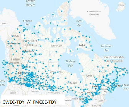
644 datasets of Typical Meteorological Years (TMY) created by joining twelve Typical Meteorological Months selected from a database of up to 20 years of CWEEDS hourly data. The months are chosen by statistically comparing individual monthly means with long-term monthly means for daily total global solar irradiance, mean, minimum and maximum dry bulb temperature, mean, minimum and maximum dew point temperature, and mean and maximum wind speed. These hourly datasets are used by the engineering and scientific community mainly as inputs for solar system design and analysis and building energy systems analysis tools. This dataset has been updated with the most recent changes made in March 2023. The solar values in these files are based on 0.1° x 0.1° (11 km x 11 km grid) for all of Canada. Refer to Data Resources below for additional information on the TMY file format.
-

644 datasets of hourly meteorological data for all of Canada from various periods (1998 to 2020). The values of the records for solar irradiance are primarily based on satellite-derived solar estimates. This dataset has been updated with the most recent changes made in March 2023. The solar values in these files are based on 0.1° x 0.1° (11 km x 11 km grid) for all of Canada. Refer to Data Resources below for additional information on the CWEEDS file format and revision history.
-

This dataset identifies potential low head hydropower development sites across Canada, based on a comprehensive review of existing studies and resource databases. Low head hydropower refers to sites where the vertical drop (head) is 15 meters or less. Sites included in this dataset also have an estimated generation capacity of 50 megawatts (MW) or less. The original database was developed by Hatch Ltd. for Natural Resources Canada (NRCan) as part of a national low head hydropower market assessment. It integrates data from multiple sources, including provincial inventories, prior Hatch studies, and legacy fieldwork records. To enhance data completeness, NRCan subsequently revised the database by supplementing missing site names, river names, and geographic coordinates where possible. The finalized dataset comprises 2,629 potential low head hydropower sites distributed across Canada. It is provided in the form of provincial and territorial shapefiles, each containing detailed site-level attributes. Attributes include site name, river name, site ID, source of information, local map number, geographic coordinates (X and Y), site region, presence of a dam, grid connection status, Indigenous affiliation, catchment area, mean annual flow, rated discharge, gross head, penstock length and diameter, estimated installed capacity, dedicated transmission line length, site comments, and Indigenous reserve name. Disclaimer: This dataset was developed to support preliminary assessments of low head hydropower potential in Canada and is subject to the following limitations: • The original database was compiled from various secondary sources, including data provided by third-party contributors and Hatch Ltd.’s own records. Some of these sources date back several decades. The data provided has not necessarily undergone independent verification for its accuracy, completeness, or validity. • NRCan undertook a data revision process involving manual review and geolocation using publicly available mapping tools (e.g., Google Maps) to address missing information. Where geographic coordinates could not be reliably determined, this is explicitly indicated in the dataset. • Site conditions may have changed over time due to natural processes or human activities. NRCan does not accept responsibility for any impact such changes may have on the accuracy or validity of the dataset’s observations, conclusions, or recommendations. • The inclusion of a site in this dataset does not imply technical, economic, or environmental feasibility. Any potential development would require further investigation, including detailed field studies, environmental assessments, and comprehensive technical and financial evaluations. This dataset is provided for informational purposes only and is not intended to serve as the sole basis for investment, planning, or development decisions. Users are strongly advised to undertake independent due diligence, including site-specific assessments and technical evaluations, prior to making any decisions based on the dataset. By accessing or using this dataset, users acknowledge and accept these terms and limitations. The dataset providers expressly disclaim any responsibility or liability for consequences resulting from the use, interpretation, or reliance on the information contained herein. Use of this dataset is entirely at the user’s own risk, and users assume full responsibility for any actions or decisions made based on its contents. This disclaimer is provided in accordance with applicable laws and regulations. By utilizing the dataset, users agree to release the dataset providers from any legal claims, damages, or liabilities that may arise from such use.
-
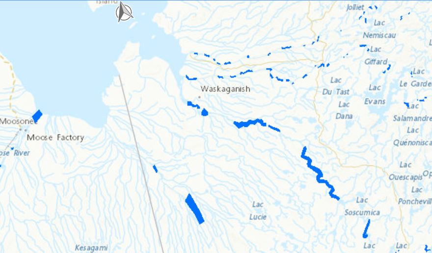
Locations of open water within river ice in Manitoba, Ontario, Quebec, and the Maritimes were discerned manually using publicly accessible optical satellite images spanning from 2013 to 2020. This initial effort has led to a dataset pinpointing potential sites for river hydrokinetic energy initiatives. A more comprehensive dataset encompassing the entirety of Canada’s major freezing rivers has also been developed entitled “Hydrokinetic Resource Mapping - Optical Satellite Imagery Analysis of Open Water Regions in Ice-Covered Canadian Rivers” and is available at (https://search.open.canada.ca/openmap/61b4e576-9f3a-49a1-9546-b29be14787a4). Disclaimer: The identification of open water locations within river ice in Manitoba, Ontario, Quebec, and the Maritimes, as described, was conducted manually through the analysis of publicly available optical satellite images. This dataset is subject to the following limitations: 1- The manual identification method may introduce potential human error and subjectivity within the dataset. 2- The publicly accessible satellite images employed may not provide fully comprehensive or entirely accurate representations of the actual conditions in the identified locations due to image resolution constraints, cloud cover, or atmospheric interference. This dataset is intended for preliminary assessment and should not be the sole basis for making critical decisions or investments related to hydrokinetic energy projects. Further validation and in-depth analysis are strongly recommended, and users should conduct their own due diligence and additional research to verify the data accuracy and relevance for specific applications. By accessing and using this dataset, users acknowledge and accept these disclaimers. The providers of this dataset explicitly absolve themselves of any responsibility or liability for any consequences arising from the use, reliance upon, or interpretation of this dataset. Users are advised that their use of the dataset is at their own risk, and they assume full responsibility for any actions or decisions made based on the information contained therein. This disclaimer is in accordance with applicable laws and regulations, and by accessing or utilizing the dataset, users agree to release the providers of this dataset from any legal claims, damages, or liabilities that may arise from such use.
-

A tidal resource assessment dataset for the Quatsino Sound region, British Columbia, was developed, including temporal maximum, mean, and minimum velocity magnitudes, standard deviations, and power density. The dataset was generated using a high-resolution 2D depth-averaged hydrodynamic model based on the Telemac-Mascaret solver, with Natural Neighbor interpolation applied for raster creation. This newly published dataset is the first in a series of regional tidal energy maps for Canada. Developed by CanmetENERGY Ottawa in collaboration with partners, these maps aim to support effective project planning and development by providing comprehensive tidal resource data across the country. Disclaimer: Potential errors in the model results may arise from inherent limitations in the topo-bathymetric data accuracy, assumptions in boundary conditions, approximations within the numerical methods, and the input data used in the numerical modeling. These factors introduce uncertainties that can affect the overall model outcomes. The model is subject to the following conditions: • Topo-bathymetric data: Obtained from electronic navigational charts and the Canadian Hydrographic Service’s (CHS) NONNA-10 Bathymetric Data packages, consolidating CHS-managed digital bathymetric sources with a maximum resolution of 10 m. • Tidal and current harmonic components: Used as boundary conditions from the TPXO9 global tidal model. • Model calibration and validation: Performed using data from Acoustic Doppler Current Profilers (ADCP), surface elevations recorded at CHS tidal stations, and Lagrangian drifter measurements. • Interpolation method: Dataset outputs were generated with Natural Neighbor interpolation, which assumes smoothly varying data and may not capture sharp local gradients or features. • Modeled estimates: All values for velocity magnitudes, velocity standard deviations, and power density are modeled estimates and not direct field measurements. This dataset is intended for preliminary assessment of tidal projects only. It should not be the sole basis for making critical decisions or investments. We strongly recommend further validation and in-depth analysis. Users are responsible for conducting their own due diligence and additional research to verify the data's accuracy and relevance for specific applications. By accessing and using this dataset, users acknowledge and accept these disclaimers. The providers of this dataset explicitly absolve themselves of any responsibility or liability for any consequences arising from the use, reliance upon, or interpretation of this dataset. Users are advised that their use of the dataset is at their own risk, and they assume full responsibility for any actions or decisions made based on the information contained therein. This disclaimer is in accordance with applicable laws and regulations, and by accessing or utilizing the dataset, users agree to release the providers of this dataset from any legal claims, damages, or liabilities that may arise from such use.
-
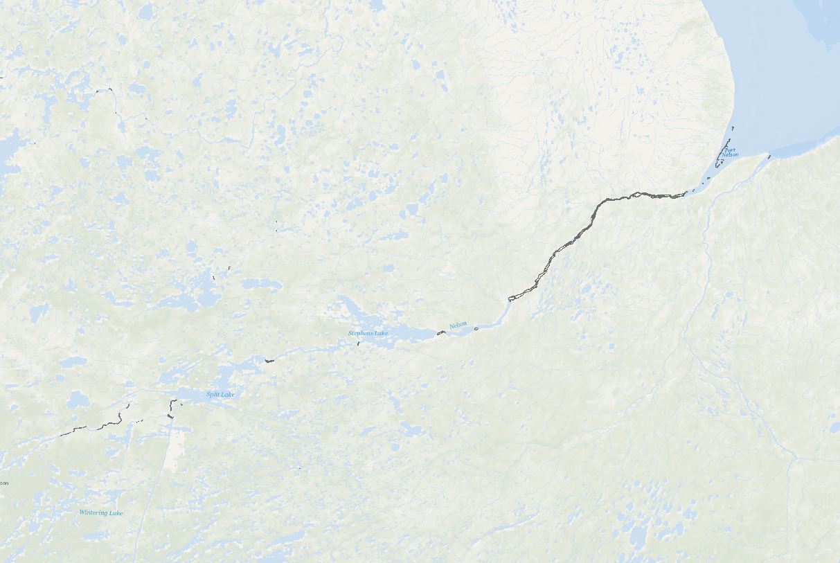
Building on the initial effort (“Database of Open Water Areas in River Ice for Provinces of Manitoba, Ontario, Quebec, and the Maritimes - Potential Locations For River Hydrokinetic Energy Extraction Identified Through Optical Satellite Imager”; weblink: https://search.open.canada.ca/openmap/d9823004-29aa-40e2-aa47-9c54cf88c309), a follow-up research project has led to the publication of this extensive analysis encompassing the entirety of Canada’s major freezing rivers. This work has applied advanced image processing and classification algorithms to the selected images, elevating the classification and analysis to a higher level of accuracy and providing a more comprehensive dataset for exploring river hydrokinetic energy prospects across the country. This dataset identifies open water areas within ice-covered major Canadian rivers, aiming to evaluate potential hydrokinetic resources. The data is derived from high-resolution optical satellite imagery obtained from Landsat and Sentinel satellites corresponding to National Research Council (NRC) 2014 flow data of river reaches with water depths of at least 10 meters and a flow velocity of a minimum of 0.5 meters per second. Using advanced image processing and machine learning algorithms, the dataset efficiently differentiates between ice-covered and open water regions, providing a reliable basis for assessing hydrokinetic energy potential in the identified areas. Disclaimer: This dataset is subject to the following limitations: • Landsat and Sentinel optical satellite images are high-resolution, but they may contain resolution errors, possible distortions, and inaccuracies in depicting on-ground conditions. • Despite advanced image processing and machine learning algorithms, errors or biases may exist. • The dataset's reliability is also influenced by the NRC flow data. Therefore, users should view this dataset as a preliminary assessment tool, not a definitive guide for decision-making or investment in hydrokinetic projects. It is strongly recommended to validate its accuracy and suitability for specific applications through additional research and studies. By accessing and using this dataset, users acknowledge and accept these disclaimers. The providers of this dataset explicitly absolve themselves of any responsibility or liability for any consequences arising from the use, reliance upon, or interpretation of this dataset. Users are advised that their use of the dataset is at their own risk, and they assume full responsibility for any actions or decisions made based on the information contained therein. This disclaimer is in accordance with applicable laws and regulations, and by accessing or utilizing the dataset, users agree to release the providers of this dataset from any legal claims, damages, or liabilities that may arise from such use.
-

The Remote Communities Energy Database is a public resource that provides pertinent factual information about the generation and use of electricity and other energy sources for all remote communities in Canada. Communities are identified as remote communities if they are not currently connected to the North-American electrical grid nor to the piped natural gas network; and is a permanent or long-term (5 years or more) settlement with at least 10 dwellings. The Remote Communities Energy Database is the only national data source on energy in remote communities that is publically available on one centralized site. The Remote Communities Energy Database allows users to search and conduct analyses of remote communities and their energy context. Users are also able download the data from the Remote Communities Energy Database dataset in CSV (i.e., excel compatible) format. This data is collected from a number of sources including the remote communities themselves, local utilities, provincial and territorial government’s, Indigenous and Northern Affairs Canada (INAC), Statistics Canada, Natural Resources Canada (NRCan) and various other stakeholders.
-

The Remote Communities Energy Database (RCED) is a tool that aims to collect and show pertinent information about the generation and use of electricity and other energy sources for all remote communities of Canada. This data is collected from a variety sources, including Statistics Canada, Provincial and Territorial Governments, utilities, public reports and communities. The term “remote community” refers to any community not currently connected to the North American electrical grid nor to the piped natural gas network; and which is a permanent or long-term (five years or more) settlement with at least 10 dwellings. Disclaimer: Natural Resources Canada (NRCan) accepts no responsibility or liability for any errors, inaccuracies and/or omissions in the Remote Communities Energy Database (RCED). The content of the RCED is a compilation of data obtained from many sources and the data is subject to change without notice. Neither does NRCan warrant or guarantee that the information is accurate, complete or current at all times. In no event will NRCan or the Government of Canada and its employees be liable or responsible for any damages resulting from any such errors, inaccuracies or omissions nor will they be liable or responsible for any lost profits, loss of revenue or earnings, claims by third parties or for any economic, indirect, special, incidental, consequential or exemplary damage including but not limited to any demands or causes of action in contract, tort or otherwise including any liability for negligence.