 Arctic SDI catalogue
environmental policy
Type of resources
Available actions
Topics
Keywords
Contact for the resource
Provided by
Years
Formats
Resolution
-
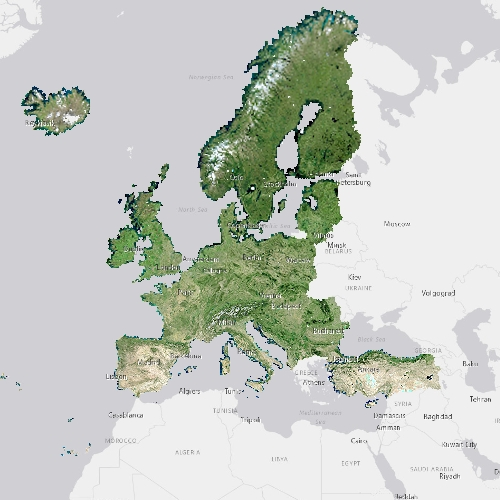
The pan-European High Resolution (HR) Image Mosaic 2006 provides HR2 (High Resolution: 20 meter) coverage over Europe. The surface covered by the image dataset is 5.8 million square kilometres and has a spatial resolution of 20 meters. The imagery is composed during specific acquisition windows between 2005 and 2007. Images are derived from the following satellite sensors: Resourcesat-1 SPOT-4/-5 The mosaic primarily is used as input data in the production of various Copernicus Land Monitoring Service (CLMS) datasets and services, such as land cover maps and high resolution layers on land cover characteristic and can be also useful for CLMS users for visualizations and classifications on land. The input imagery for the creation of the mosaic is provided by ESA. Due to license restrictions, HR Image Mosaic 2006 is only available as a web service (WMS), and not for data download.
-

The Sentinel-2 Snow Phenology (SP S2) product is generated once a year at European scale, based on Fractional Snow Cover (FSC) products calculated from Sentinel-2 optical data. This product describes the snow season in terms of temporality as it provides, within an hydrological year and for each pixel, the number of days with snow cover, as well as the first and the last day of the longest observed snow period. It has a spatial resolution of 20 m x 20 m, as does the input FSC product. The SP S2 product is distributed in raster files covering an area of 110 km by 110 km with a pixel size of 20 m by 20 m in UTM/WGS84 projection, which corresponds to the Sentinel-2 input L1C product tile. Each product is composed of separate files corresponding to the different layers of the product, and another metadata file." The product is also available in another projection as tiles aligned with the Pan-European High-Resolution Layers in the European grid (ETRS89 LAEA - EPSG: 3035) at 20 m x 20 m and 100 m x 100 m. SP S2 is one of the products of the pan-European High-Resolution Water Snow & Ice portfolio (HR-WSI), which are provided at high spatial resolution from the Sentinel-2 and Sentinel-1 constellations data from September 1, 2016 onwards.
-
The pan-European Very High Resolution (VHR) Image Mosaic 2021 is a seamless mosaic of the VHR 2021 dataset. The input data consists of a mix of Pleiades, SuperView, Worldview, Kompsat-3, Kompsat-4, Geoeye, SPOT, Deimos-2, Vision-1 and TripleSat images. To enhance the appearance of the input imagery, a histogram stretch was applied, cutting off the lowest and highest 0.1 percent of the histogram values and stretching the remaining values to fit the 16-bit pixel depth. For each input image, only selected areas were used to create the mosaic, and the rest was masked out to exclude areas with clouds and their shadows. Color balance was achieved using a second-order method, which modifies all input pixels toward a set of multiple points derived from a two-dimensional polynomial parabolic surface, ensuring a seamless mosaic. For several water bodies, especially large lakes, the final result exhibited a patchy surface pattern due to presence of sun glint on the satellite images. A post-processing methodology was implemented to recalculate the digital values to produce a seamless appearance surface of some of these major lakes: Vänern and Vättern (Sweden), Oulu (Finland), Peipus (Estonia), Geneva (Switzerland/France), Constance (Switzerland/Germany/Austria), Garda and Bolsena (Italy), Skadar (Montenegro/Albania), Prespa (North Macedonia/Albania/Greece), Beysehir, Iznik and Van (Turkey). The applied methodology consisted of creating individual mosaics with the images comprising only the mentioned lakes (a mosaic per lake), calculating Normalized Difference Vegetation Index (NDVI) for shoreline extraction, and color balancing each mosaic individually with all land surfaces masked out, using only pixels belonging to the water category. This approach allowed smoothing the patchy surfaces of the above-mentioned lakes considering statistics solely from the water pixels, ensuring a more uniform appearance. To enhance the visualization of the entire dataset at larger scales (greater than 1:500.000), the mosaic displays pan-European overviews generated from the pan-European Very High Resolution 2018 Image Mosaic. The updated VHR 2021 version is visualized only at scales below 1:500.000. The mosaic primarily is used as input data in the production of various Copernicus Land Monitoring Service (CLMS) datasets and services, such as land cover maps and high-resolution layers on land cover characteristic. It can be also useful for CLMS users for visualizations and classifications on land. The input imagery for the creation of the mosaic is provided by ESA. Due to license restrictions, the VHR Image Mosaic 2021 is only available as a web map service (WMS), and not for data download.
-
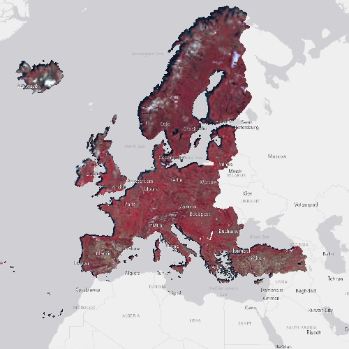
The pan-European High Resolution (HR) Image Mosaic 2006 provides HR2 (High Resolution: 20 meter) coverage over Europe. The surface covered by the image dataset is 5.8 million square kilometres and has a spatial resolution of 20 meters. The imagery is composed during specific acquisition windows between 2005 and 2007. Images are derived from the following satellite sensors: Resourcesat-1 SPOT-4/-5 The mosaic primarily is used as input data in the production of various Copernicus Land Monitoring Service (CLMS) datasets and services, such as land cover maps and high resolution layers on land cover characteristic and can be also useful for CLMS users for visualizations and classifications on land. The input imagery for the creation of the mosaic is provided by ESA. Due to license restrictions, HR Image Mosaic 2006 is only available as a web service (WMS), and not for data download.
-

The Sentinel-1 and Sentinel-2 Snow Phenology (SP S1+S2) product is generated once a year over high-mountain areas at European scale, based on daily cumulative Gap-Filled Fractional Snow Cover (GFSC) products calculated from Sentinel-2 optical and Sentinel-1 radar data. This product describes the snow season in terms of temporality as it provides, for each pixel, the number of days with snow cover, as well as the first and the last day of the longest observed snow period. It has a spatial resolution of 100 m x 100 m. Each product is composed of separate files corresponding to the different layers of the product, and another metadata file. The product is also available in another projection as tiles aligned with Sentinel-2 (UTM/WGS84) at 60 m x 60 m. SP S1+S2 is one of the products of the pan-European High-Resolution Water Snow & Ice portfolio (HR-WSI), which are provided at high spatial resolution from the Sentinel-2 and Sentinel-1 constellations data from September 1, 2016 onwards. t.
-
The Sentinel-2 Snow Phenology (SP S2) product is generated once a year at European scale, based on Fractional Snow Cover (FSC) products calculated from Sentinel-2 optical data. This product describes the snow season in terms of temporality as it provides, within an hydrological year and for each pixel, the number of days with snow cover, as well as the first and the last day of the longest observed snow period. It has a spatial resolution of 100 m x 100 m. Each product is composed of separate files corresponding to the different layers of the product, and another metadata file." The product is also available in another projection as tiles aligned with Sentinel-2 (UTM/WGS84) at 20 m x 20 m. SP S2 is one of the products of the pan-European High-Resolution Water Snow & Ice portfolio (HR-WSI), which are provided at high spatial resolution from the Sentinel-2 and Sentinel-1 constellations data from September 1, 2016 onwards.
-

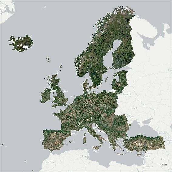
The pan-European High Resolution (HR) Image Mosaic 2018 provides cloud-free high resolution false colour imagery for EEA39 countries. The mosaic has been produced using Sentinel-2 data in 10 meter resolution, at a Sentinel 2 tile level, and consists of 1079 Sentinel-2 tiles. The imagery for each state is acquired within a predefined window corresponding to the vegetation season in 2018. The false colour composite consists of a three band stack and includes the following bands: Band 8 – NIR (0.842 μm) Band 4 – Red (0.665 μm) Band 3 – Green (0.560 μm) The mosaic primarily is used as input data in the production of various Copernicus Land Monitoring Service (CLMS) datasets and services, such as land cover maps and high resolution layers on land cover characteristic and can be also useful for CLMS users for visualizations and classifications on land. can be also used to automatically create mosaics over the area of interest.
-

The pan-European High Resolution (HR) Image Mosaic 2015 provides up to two cloud-free HR optical coverage 2 of EEA39 countries including all islands of those countries plus French Overseas Departments (DOMs) acquired within predefined windows corresponding to the vegetation season in 2014-2015. Images are derived from the following satellite sensors: Resourcesat-1/2 SPOT-5 Sentinel-2 MSI The mosaic primarily is used as input data in the production of various Copernicus Land Monitoring Service (CLMS) datasets and services, such as land cover maps and high resolution layers on land cover characteristic and can be also useful for CLMS users for visualizations and classifications on land. The input imagery for the creation of the mosaic is provided by ESA. Due to license restrictions, HR Image Mosaic 2015 is only available as a web service (WMS), and not for data download.
-

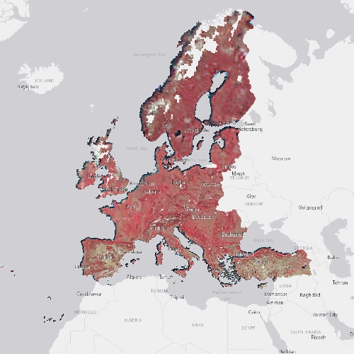
The pan-European High Resolution (HR) Image Mosaic 2009 provides HR2 (High Resolution: 20 meter) coverage over Europe. The surface covered by the image dataset is 5.8 million square kilometres and has a spatial resolution of 20 meters. The imagery is composed during specific acquisition windows between 2008 and 2010. Images are derived from the following satellite sensors: Resourcesat-1 SPOT-4/-5 The mosaic primarily is used as input data in the production of various Copernicus Land Monitoring Service (CLMS) datasets and services, such as land cover maps and high resolution layers on land cover characteristic and can be also useful for CLMS users for visualizations and classifications on land. The input imagery for the creation of the mosaic is provided by ESA. Due to license restrictions, HR Image Mosaic 2009 is only available as a web service (WMS), and not for data download.
-
The pan-European High Resolution (HR) Image Mosaic 2012 provides HR1 (High Resolution: 5 meter) coverage over Europe. The surface covered by the image dataset is 5.8 million square kilometres and has a spatial resolution of 5 meters. The imagery is composed during specific acquisition windows in 2011, 2012 and 2013. Coverage 2 acquisitions are expected to be 6 weeks away from Coverage 1, down to a minimum of 2 weeks for northern countries, including United Kingdom. The ± 6 weeks criteria might not be strictly applied over Atlantic Islands and French DOMs (seasonal changes are limited in the equatorial DOMs). Images are derived from the following satellite sensors: RapidEye constellation The mosaic primarily is used as input data in the production of various Copernicus Land Monitoring Service (CLMS) datasets and services, such as land cover maps and high resolution layers on land cover characteristic and can be also useful for CLMS users for visualizations and classifications on land. The input imagery for the creation of the mosaic is provided by ESA. Due to license restrictions, HR Image Mosaic 2012 is only available as a web service (WMS), and not for data download.