water
Type of resources
Available actions
Topics
Keywords
Contact for the resource
Provided by
Years
Formats
Representation types
Update frequencies
status
Service types
Scale
Resolution
-
Yukon Water Sampling Sites for the Yukon Water application
-

Data on physical conditions in Ontario’s lakes and streams: * For lakes this includes measurements such as temperature, dissolved oxygen levels and water transparency, ice dates, as well as sampling location details. * For streams this includes measurements such as stream flow discharge from monitoring stations in south-central Ontario. Meteorological conditions for climate stations close to monitored lakes in south-central Ontario, includes measurements such as air temperature, humidity, precipitation and wind speed. This data set includes information on sampling locations and physical conditions in lakes and streams across Ontario, as well as meteorological and lake ice-cover conditions from monitoring stations in south-central Ontario. Data were collected since 1976, as part of routine monitoring of water quality of inland waters and for scientific and research purposes. Keywords: water quality, meteorology, hydrology, wind, dissolved oxygen, environmental monitoring
-

Drinking fountains in Quebec City.**This third party metadata element was translated using an automated translation tool (Amazon Translate).**
-
City of Trois-Rivières pressure reduction valves**This third party metadata element was translated using an automated translation tool (Amazon Translate).**
-

This collection represents the authoritative watershed boundaries for Ontario. The data is based on a framework similar to the [Atlas of Canada Fundamental Drainage Areas](https://open.canada.ca/data/en/dataset/a4b190fe-e090-4e6d-881e-b87956c07977) and the [United States Watershed Boundary Dataset](https://www.usgs.gov/core-science-systems/ngp/national-hydrography/watershed-boundary-dataset?qt-science_support_page_related_con=4#qt-science_support_page_related_con), however it adopts a more stringent scientific approach to watershed delineation. The Ontario Watershed Boundaries (OWB) collection includes five data classes: * OWB main: all levels from primary to quaternary and 5th and 6th levels in select areas * OWB primary: all primary watersheds or major drainage areas in the Canadian classification * OWB secondary: all secondary watersheds or sub drainage areas * OWB tertiary: all tertiary watersheds or sub sub drainage areas * OWB quaternary: all quaternary watersheds or 6-digit drainage areas. The OWB data replaces the following data classes: * [Provincial Watersheds, Historical](https://data.ontario.ca/dataset/provincial-watersheds-historical)
-
Wells and reservoirs in the City of Trois-Rivières**This third party metadata element was translated using an automated translation tool (Amazon Translate).**
-
Pressure maintaining valves from the Cities of Trois-Rivières**This third party metadata element was translated using an automated translation tool (Amazon Translate).**
-

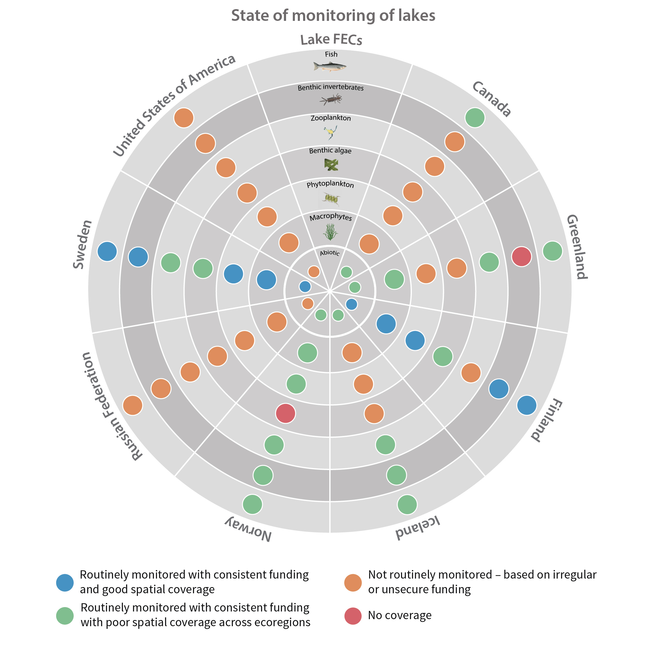
Although the circumpolar countries endeavor to support monitoring programs that provide good coverage of Arctic and subarctic regions, this ideal is constrained by the high costs associated with repeated sampling of a large set of lakes and rivers in areas that often are very remote. Consequently, freshwater monitoring has sparse, spatial coverage in large parts of the Arctic, with only Fennoscandia and Iceland having extensive monitoring coverage of lakes and streams Figure 6-1 Current state of monitoring for lake FECs in each Arctic country. State of the Arctic Freshwater Biodiversity Report - Chapter 6 - Page 93 - Figure 6-1
-
Drinking water pipes in the city of Trois-Rivières.**This third party metadata element was translated using an automated translation tool (Amazon Translate).**
-
City of Trois-Rivières flow control valve**This third party metadata element was translated using an automated translation tool (Amazon Translate).**
 Arctic SDI catalogue
