 Arctic SDI catalogue
marine geology
Type of resources
Available actions
Topics
Keywords
Contact for the resource
Provided by
Years
Formats
Representation types
Update frequencies
status
Service types
Resolution
-

Grain size is the most fundamental physical property of sediment, and these data are widely used in a variety of applications in science. Marine expeditions of the Geological Survey of Canada have been collecting grain size information on seabed and sub-seabed samples for over 50 years. Results have been recorded at 5th phi midpoints since the early 1990's in contrast to the earlier full, half or quarter phi interval end point values. Users of high resolution data must note that the sum of %Silt and %Clay equals the total %Mud makeup and that %Gravel, %Sand, %Silt and %Clay sum to 100%. Summary statistics include percentages of gravel, sand, silt, clay and mud as well as mean, kurtosis, skewness and standard deviation. The quality of these data varies. Results should be used with some caution as they may not be fully representative of seabed grainsize, particularly in areas of sandy and coarser sediment (e.g., sand and mud can leak out of the sampler during recovery). Canada makes no representation or warranty of any kind with respect to the accuracy, usefulness, novelty, validity, scope, completeness or currency of the data and expressly disclaims any implied warranty of merchantability or fitness for a particular purpose of the data. For the purpose of the web mapping service, grain size data are sorted by the expedition id. Coarse and detailed grain size distribution plots are shown when a point is chosen. If the sample contains more that one sub-sample ( e.g., as with a piston core sequence), the grain size plots are stacked in the display window from the top of the core downwards.
-

The Marine Geoscience for Marine Spatial Planning (MGMSP) program, implemented by Natural Resources Canada (NRCan), is an initiative with the goal of offering innovative regional geoscience products to support the Department of Fisheries and Oceans (DFO) in their Marine Spatial Planning endeavors. To develop spatial management plans for various expansive bioregions across Canada, the DFO has undertaken the task of creating comprehensive ocean management strategies. Presently, the MGMSP program is concentrating its efforts on two significant bioregions, namely the Scotian Shelf and Newfoundland and Labrador Shelves bioregions. In pursuit of this objective, the work presented in this report has focused on the assimilation and gridding of numerous disparate bathymetry datasets sourced from authoritative and reliable channels. The purpose of this comprehensive data gathering approach is to establish a unified bathymetric grid, with a consistent spatial resolution, which can be utilized in both oceanographic modeling and geological interpretation. By collating information from a diverse range of sources, we aim to create a comprehensive and reliable foundation that will enable accurate and informed decision-making in the field of marine spatial planning, as well as enhance the accuracy and reliability of subsequent analyses and simulations.
-
The map service incorporates submarine slides. Slides are presented as polygons in addition to boundaries of the slides. The data has been compiled from several sources, with differing details. The main source for the slides on the Norwegian continental shelf is the Seabed project (Norwegian Deepwater Programme, Seabed project Phase II. Mid-to Late Cenozoic Geomodel of the Mid-Norwegian Continental Margin. Atlas volume (Report no. SP2-02-FS-01R-00003-04); By Fugro Survey Ltd., BGS, NGU). For slides in the other countries, the COSTA project (COSTA - Continental Slope Stability, 2004. Ed. J. Mienert. Marine Geology 213, 1-4, pp. 1-504) is the main source. Minor sources include various scientific publications and the Norwegian MAREANO project. Source information is available through the info button in the map service.
-
.png)
The WMS MSSP-EEZ (INSPIRE) represents marine seismic survey profiles for the German EEZ. During the period from 1996 to 2007 five cruises operated by BGR acquired seismic lines from the German EEZ. The aim of these cruises was a detailed survey of the geological structure of the seabed from the North Sea and Baltic Sea. According to the Data Specification on Geology (D2.8.II.4_v3.0, subtopic Geophysics) the content of the information with respect to the seismic profiles is INSPIRE-compliant. The WMS MSSP-EEZ (INSPIRE) contains for each cruise one layer, e.g. GE.seismicLine.pq2. The expeditions are displayed correspondingly to the INSPIRE portrayal rules. Via the getFeatureInfo request the user obtains the content of the INSPIRE attributes platformType und profileType. Additionally, the WMS contains a campaign layer (GE.2DSeismicSurvey) with the INSPIRE attributes campaignType and surveyType.
-
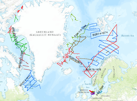
During the period from 1974 to 2010 various cruises from BGR acquired seismic lines worldwide. The aim of these marine expeditions was a detailed survey of the geological structure.