 Arctic SDI catalogue
Biological Classification
Type of resources
Topics
Keywords
Contact for the resource
Provided by
Formats
Representation types
Update frequencies
status
-

“4VSW” missions focus on the eastern half of the Scotian Shelf, and occur primarily in March, but sets in both February, and April are also present in the data. These missions use a unique stratification scheme intended to optimize the abundance estimates of cod. Collected data includes total catch in numbers and weights by species. Length frequency data is available for most species, as are the age, sex, maturity and weight information for a subset of the individual animals. Other data such as ageing material, genetic material, and stomach contents are often also collected, but are stored elsewhere. Cite this data as: Clark, D., Emberley, J. Data of Maritimes 4VSW Research Vessel Survey. Published January 2021. Population Ecology Division, Fisheries and Oceans Canada, Dartmouth, N.S. https://open.canada.ca/data/en/dataset/a851ce30-e216-4d7d-a29c-05631eef140e
-

"Fall" missions occur primarily in October and November, but sets from September and December are also present in the data. Collected data includes total catch in numbers and weights by species. Length frequency data is available for most species, as are the age, sex, maturity and weight information for a subset of the individual animals. Other data such as ageing material, genetic material, and stomach contents are often also collected, but are stored elsewhere. "Fall" cruises occur in September, October, November and December. Cite this data as: Clark, D., Emberley, J. Data of Maritimes Fall Research Vessel Survey. Published January 2021. Population Ecology Division, Fisheries and Oceans Canada, Dartmouth, N.S. https://open.canada.ca/data/en/dataset/5f82b379-c1e5-4a02-b825-f34fc645a529
-

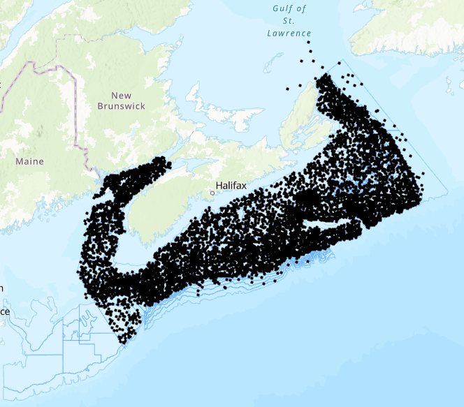
The Fisheries and Oceans Canada (DFO) ecosystem surveys consist of research vessel survey data collected to monitor the distribution and abundance of fish and invertebrates throughout the Scotian Shelf, Bay of Fundy and Georges Bank. The surveys follow a stratified random sampling design, and include sampling of fish and invertebrates using a bottom otter trawl. These survey data are the primary data source for monitoring trends in species distribution, abundance, and biological condition within the region, and also provide data to the Atlantic Zonal Monitoring Program (AZMP) for monitoring hydrographic variability. Collected data includes total catch in numbers and weights by species. Length frequency data is available for most species, as are the age, sex, maturity and weight information for a subset of the individual animals. Other data such as ageing material, genetic material, and stomach contents are often also collected, but are stored elsewhere. “Spring” cruises occur in January, February, March and April, and focus on Georges Bank (i.e. 5Z). Cite this data as: Clark, D., Emberley, J. Data of MARITIMES SPRING RESEARCH VESSEL SURVEY. Published January 2021. Population Ecology Division, Fisheries and Oceans Canada, Dartmouth, N.S. https://open.canada.ca/data/en/dataset/fecf045a-95a2-4b69-8a40-818649a62716
-
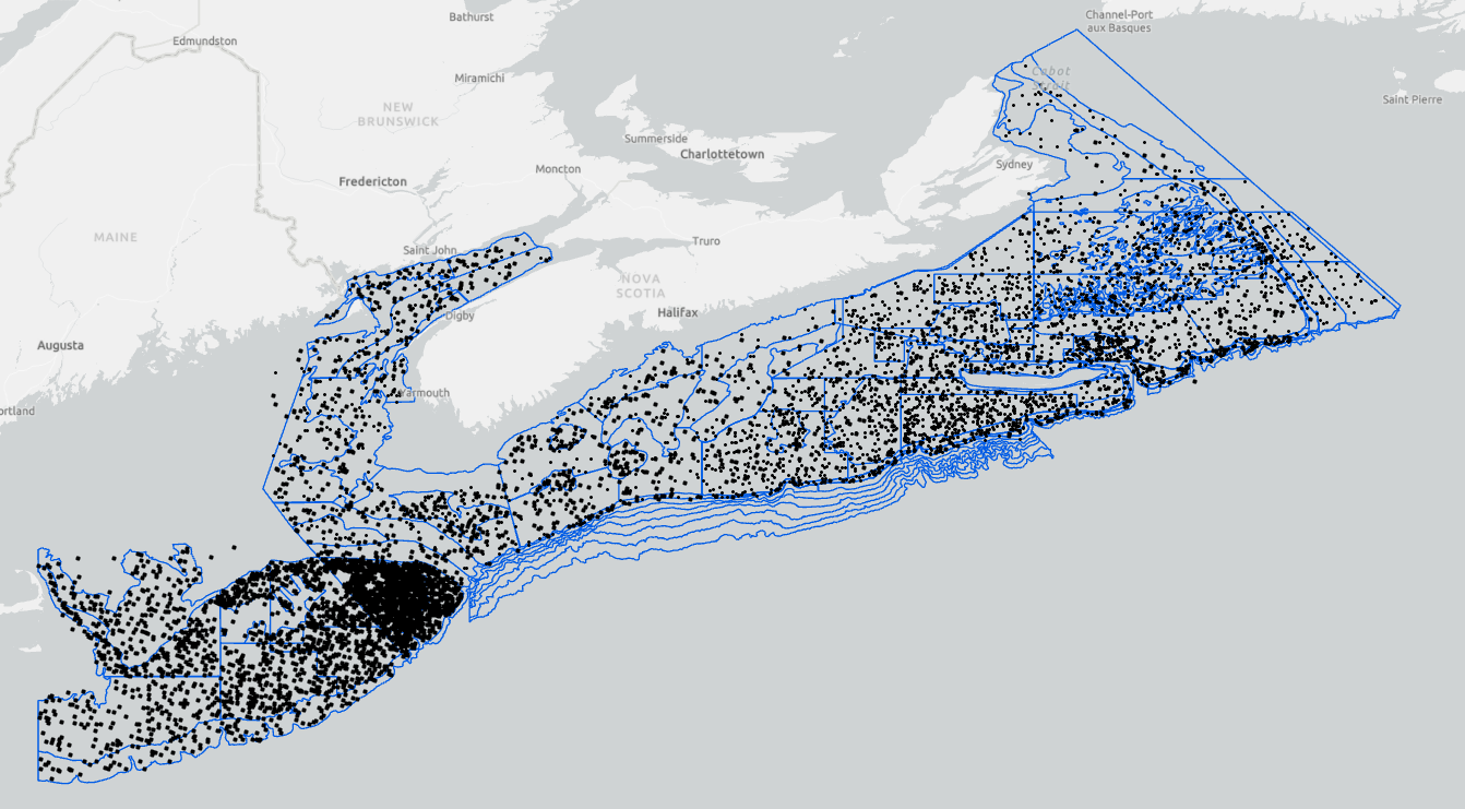
The Fisheries and Oceans Canada ecosystem surveys are conducted annually and are a source of integrated ecosystem monitoring data. These survey data are the primary data source for monitoring trends in species distribution, abundance, and biological condition within the region, and also provide data to the Atlantic Zonal Monitoring Program (AZMP) for monitoring hydrographic conditions, along with zooplankton and phytoplankton. The surveys follow a stratified random sampling design, and include sampling using a bottom otter trawl, CTD rosette and vertical plankton tows. Data from the bottom trawl catch are used to monitor the distribution and abundance of fish and invertebrates throughout the Scotian Shelf, Bay of Fundy and Georges Bank. Cite this data as: Clark, D., Emberley, J. Data of MARITIMES RESEARCH VESSEL SURVEYS. Published January 2021. Population Ecology Division, Fisheries and Oceans Canada, Dartmouth, N.S. https://open.canada.ca/data/en/dataset/8ddcaeea-b806-4958-a79f-ba9ab645f53b
-
“Summer” missions occur in June, July and August and these focus on the Scotian Shelf and Bay of Fundy (i.e. 4VWX 5Yb, expanding recently to include the Laurentian Channel and Georges Bank (5Zc). Collected data includes total catch in numbers and weights by species. Length frequency data is available for most species, as are the age, sex, maturity and weight information for a subset of the individual animals. Other data such as ageing material, genetic material, and stomach contents are often also collected, but are stored elsewhere. “Summer” cruises occur in May, June, July and August and these focus on the Scotian Shelf and Bay of Fundy (i.e. 4VWX). Cite this data as: Clark, D., Emberley, J. Data of MARITIMES SUMMER RESEARCH VESSEL SURVEYS. Published January 2021. Population Ecology Division, Fisheries and Oceans Canada, Dartmouth, N.S. https://open.canada.ca/data/en/dataset/1366e1f1-e2c8-4905-89ae-e10f1be0a164
-

PURPOSE: An aerial survey of the Western Hudson Bay beluga whale (Delphinapterus leucas) population was conducted on August 19th, 2015 to provide a population estimate. Surveys were flown in a DeHavilland Twin Otter (DH-6) fitted with four bubble windows and an optical glass-covered camera hatch at the rear underbelly of the plane. A Global Positioning System (GPS) unit logged the position, altitude, speed, and heading of the aircraft each second. Surveys were initially flown at a target ground speed of 100 knots (185 km/h), and target altitudes of 1,000 ft (305 m) for visual surveys and 2,000 ft (610 m) for photographic surveys. After the second day of flying, the target ground speed was adjusted to 110 knots (204 km/h). Complete coverage of the two photographic strata was achieved using a Nikon D810 camera fitted with a 25 mm lens. The camera was mounted at the rear of the aircraft and directed straight down with the longest side perpendicular to the track line. The camera was connected to a GPS unit to geo-reference photographs, and to a laptop computer to control exposure settings and photo interval. At an altitude of 2,000 ft (610 m), the 25 mm lens captured a ground area of approximately 875 m x 585 m. The photograph interval was set to maintain an overlap of 20 to 40 % between consecutive photos, and with a transect spacing of 600 m, the lateral overlap between photos from adjacent transects was approximately 30 %. DESCRIPTION: Aerial surveys of summering Western Hudson Bay (WHB) beluga (Delphinapterus leucas) were conducted on August 19th, 2015 to update the previous population abundance. The survey area comprised five strata (three visual and two photographic) encompassing high use areas around three river estuaries where recurring aggregations of WHB beluga are found during the summer months. This metadata covers the photographic data related to the survey. The photographic surveys completely covered high density aggregations in the Churchill River and near the mouth of the Seal River.
-

PURPOSE: An aerial survey of the Western Hudson Bay beluga whale (Delphinapterus leucas) population was conducted on August 12th, 2015 to provide a population estimate. Surveys were flown in a DeHavilland Twin Otter (DH-6) fitted with four bubble windows and an optical glass-covered camera hatch at the rear underbelly of the plane. A Global Positioning System (GPS) unit logged the position, altitude, speed, and heading of the aircraft each second. Surveys were initially flown at a target ground speed of 100 knots (185 km/h), and target altitudes of 1,000 ft (305 m) for visual surveys and 2,000 ft (610 m) for photographic surveys. After the second day of flying, the target ground speed was adjusted to 110 knots (204 km/h). Complete coverage of the two photographic strata was achieved using a Nikon D810 camera fitted with a 25 mm lens. The camera was mounted at the rear of the aircraft and directed straight down with the longest side perpendicular to the track line. The camera was connected to a GPS unit to geo-reference photographs, and to a laptop computer to control exposure settings and photo interval. At an altitude of 2,000 ft (610 m), the 25 mm lens captured a ground area of approximately 875 m x 585 m. The photograph interval was set to maintain an overlap of 20 to 40 % between consecutive photos, and with a transect spacing of 600 m, the lateral overlap between photos from adjacent transects was approximately 30 %. DESCRIPTION: Aerial surveys of summering Western Hudson Bay (WHB) beluga (Delphinapterus leucas) were conducted on August 12th, 2015 to update the previous population abundance. The survey area comprised five strata (three visual and two photographic) encompassing high use areas around three river estuaries where recurring aggregations of WHB beluga are found during the summer months. This metadata covers the photographic data related to the survey. The photographic surveys completely covered high density aggregations in the Churchill River and near the mouth of the Seal River.