 Arctic SDI catalogue
Marine geology
Type of resources
Available actions
Topics
Keywords
Contact for the resource
Provided by
Formats
Representation types
Update frequencies
status
Scale
-
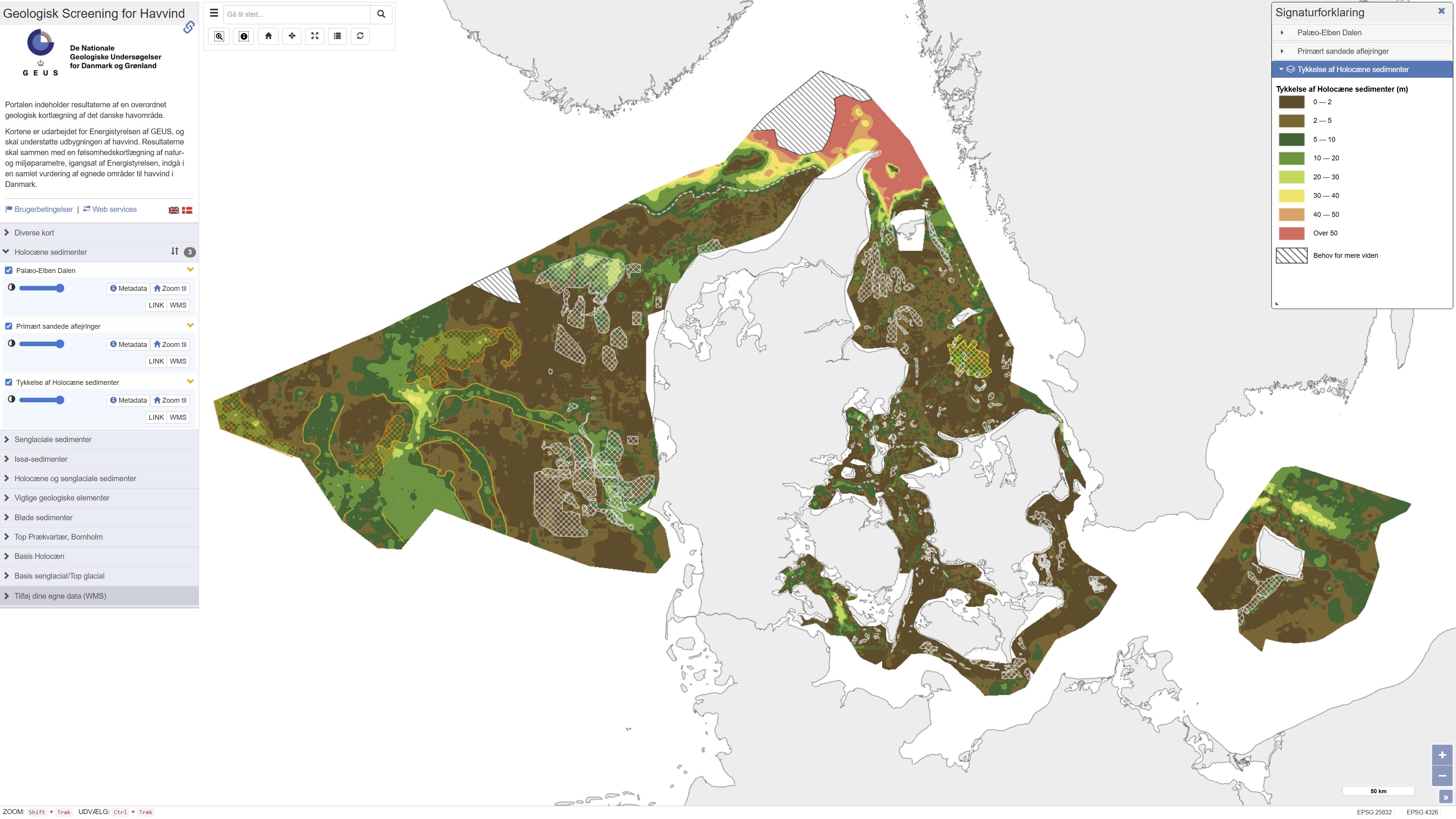
This repository contains maps of the thickness of late glacial and Holocene deposits in the Danish sea area, prepared as a basis for planning offshore wind. These are unconsolidated sediments that have not been overrun by the ice sheets of the ice ages, and therefore may have low geotechnical strength parameters. This is a large-scale and very general mapping, and no detailed interpretation of the distribution of sand and clay/mud/silt, respectively, has been made. In relation to the foundations of offshore wind turbines, sandy deposits will typically not pose a challenge, while soft deposits of clay, mud and silt in large thicknesses are assumed to pose foundation challenges. In addition to separate maps of the thickness of late glacial and Holocene deposits, a map of the total thickness of these two units has also been prepared, which thus constitutes a map of the total thickness of potentially soft sediments. Finally, the thickness of potentially soft sediments is used to divide the Danish sea area into categories in relation to the probability of larger thicknesses of soft sediments that could give rise to foundation challenges. Other maps are the thickness of potentially soft glacial lake sediments in the North Sea, the depth to the Pre-Quaternary surface in the waters around Bornholm, as well as the depth to the base of the Holocene deposits and the depth to the base of the late glacial deposits/top of the glacial deposits in the Danish sea area. As a supplement to the maps, a number of themes show where the late glacial and Holocene deposits are primarily expected to consist of sandy sediments. In addition, a number of themes show the Danish exclusive economic zone (EEZ), the location of conceptual geological models that can be seen in the overall report, all interpreted seismic lines, areas with near-surface gas in the sediments, interpreted distribution of the Palaeo-Elbe Valley in the North Sea, distribution of the Weichsel ice and ice-affected sediments in the North Sea, buried valleys (Prins & Andresen 2019; van der Vegt et al. 2012; Ottesen et al. 2020; Kirkham et al. 2024; Sandersen & Jørgensen 2016), structural elements (Al Hseinat & Hübscher 2017; Jensen et al. 2002), ice margin lines (Lange 1984; Kjær et al. 2003; Pedersen 2005; Phillips et al. 2018, 2022; Kirkham et al. 2024; Szuman et al. 2024; Pedersen & Boldreel 2017). The data basis for the work has primarily been new and existing near-surface seismic data and vibrocore drilling. The mapping was carried out for the Danish Energy Agency by GEUS, and is intended to support the development of offshore wind. The results, together with a sensitivity mapping of natural and environmental parameters, initiated by the Danish Energy Agency, are to be included in an overall assessment of suitable areas for offshore wind in Denmark.
-
%20UTM%20zone%2024N%20-%20print.png)
The dataset shows global bathymetry based on The General Bathymetric Chart of the Oceans (GEBCO) 2019. The dataset represents a continuous model of seafloor topography derived from a combination of multibeam, singlebeam and satellite altimetry data. The original global grid has been reprojected to UTM zone 24N to support regional use and integration with other geological and geophysical datasets covering Greenland and the North Atlantic.
-
%20Polar%20stereografisk%20-%20print.jpg)
The dataset shows global bathymetry based on The General Bathymetric Chart of the Oceans (GEBCO) 2019. The dataset represents a continuous model of seafloor topography derived from a combination of multibeam, singlebeam and satellite altimetry data. The dataset has been reprojected to a polar stereographic projection and published as a web-based background map for use in the ISAAFFIK Arctic Gateway portal.
-
The seabed sediment map shows the distribution of seabed sediments in Danish waters and represents an integrated interpretation of sediment types within the upper approximately 0.5 metres of the seabed. Sediment classes are defined based on grain-size composition and reflect an average of the surface sediments. Glacial till is classified as a mixed sediment, while sedimentary bedrock indicates areas where deposits several million years old are exposed on the seabed. The map was updated in 2020 and builds upon the previous version from 2014, with newly mapped areas added at full level of detail. The dataset provides a nationwide overview of seabed sedimentary conditions and is used, among other purposes, for raw material mapping, marine spatial planning, and environmental assessments.
-

Sponge reefs are constructed by hexactinellid (glass) sponges of the Order Hexactinosida. The sponges trap fine sediments, and over centuries of sponge growth and sediment trapping, form large bioherms or reef mounds. Glass sponge reefs are unique habitats found along the Pacific coast of Canada and the United States and they have significant historic, ecological, and economic value. They link benthic and pelagic environments by playing important roles in filtration and carbon and nitrogen processing, and acting as silica sinks. They also form habitat for diverse communities of invertebrates and fish, including those of economic importance. Thus, accurate and up-to-date information on the location and spatial extent of sponge reefs is important to the management and conservation of many of Canada’s Pacific marine species. We generated a map of known sponge reefs, derived from two source shape files: 1) Sponge_Reef_West_Coast, mapped by Natural Resources Canada (NRCan), 2) Howesound_Nine_reef_polygons and 3) HoweSound_Five_reef_polygons, which were mapped by DFO and NRCan. The resultant polygon shapefile is published on the GIS hub as a file geodatabase feature class.