 Arctic SDI catalogue
Water supply
Type of resources
Available actions
Topics
Keywords
Contact for the resource
Provided by
Years
Formats
Representation types
Update frequencies
status
Service types
-
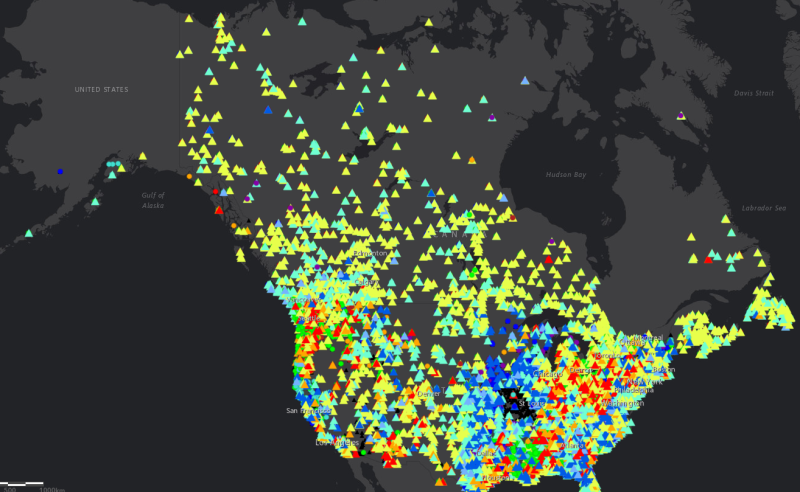
The North America Surface Water Values point dataset contains the current water level and stream flow values as recorded by Canadian and USA hydrometric gauging station locations. Daily values are recorded as well as comparisons with historical measurements, including difference in values from the previous day, the mean level for that calendar date, the annual mean water level, and maximum and minumum recorded levels. Percentile values based on historical average for both water level and stream flow are also included. Real-time gauging station data for Canada is available here: https://wateroffice.ec.gc.ca/search/statistics_e.html Real-time gauging station data for the United States is available here: https://waterservices.usgs.gov/rest/Statistics-Service.html
-

The “Annual Unit Runoff (dam3/km2) for a 80% Probability of Exceedence” dataset is a line data set that covers the extent of Canada. It shows the 80% Probability of exceedence annual unit runoff.
-

The “Annual Unit Runoff (dam3/km2) for a 90% Probability of Exceedence” dataset is a line data set that covers the extent of Canada. It shows the 90% Probability of exceedence annual unit runoff.
-
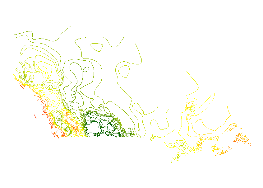
The “Annual Unit Runoff (dam3/km2) for a 50% Probability of Exceedence” dataset is a line data set that covers the extent of Canada. It shows the 50% Probability of exceedence annual unit runoff.
-

The “Annual Unit Runoff (dam3/km2) for a 10% Probability of Exceedence” dataset is a line data set that covers the extent of Canada. It shows the 10% Probability of exceedence annual unit runoff.
-

The “Annual Unit Runoff (dam3/km2) for a 25% Probability of Exceedence” dataset is a line data set that covers the extent of Canada. It shows the 25% Probability of exceedence annual unit runoff.
-

The “Stations used for Unit Runoff Analysis” dataset is a point data set for select hydrological stations that covers the extent of Canada.
-

The “Annual Unit Runoff (dam3/km2) for a 70% Probability of Exceedence” dataset is a line data set that covers the extent of Canada. It shows the 70% Probability of exceedence annual unit runoff.
-

The “Annual Unit Runoff (dam3/km2) for a 75% Probability of Exceedence” dataset is a line data set that covers the extent of Canada. It shows the 75% Probability of exceedence annual unit runoff.
-

The “AAFC Annual Unit Runoff in Canada" data series illustrates runoff trends across the country by isolines of annual unit runoff for a variety of probabilities of exceedence commonly used by decision makers Annual unit runoff is a measure of runoff volume per square kilometre. This series uses units of cubic decametres (1000 m3) per square kilometre (dam3/km2), which is equivalent to millimetres depth on the landscape. It includes a point data set for the hydrologic stations that were analyzed and seven sets of line work to show the adjusted isolines for 10%, 25%, 50%, 70%, 75%, 80%, and 90% probability of exceedence.