 Arctic SDI catalogue
World
Type of resources
Available actions
Topics
Keywords
Contact for the resource
Provided by
Years
Formats
Representation types
Update frequencies
status
Service types
Scale
-

Spider species-level data collected from pan traps across four habitat types in Cambrige Bay Nunavut. Two wet habitat types and two dry habitat types were examined. Samples continuously taken from July 3rd to August 11th 2014, but broken down into sampling periods which are, on average, 6 days long.
-

Um er að ræða 65 loftmyndir úr Breiðafirðinum af svæði sem kallað er Breiðasund. Myndirnar eru bæði innrauðar og í lit. Greinihæfnin er 0,5 metrar. Myndirnar eru teknar úr 5000-5500 m hæð. Flatarmál svæðisins er 260 km2. Myndkort gert bæði í lit og innrauðum lit í blaðskiptingu Reitakerfi Íslands 5 x 5 km. Myndir eru teknar á myndavél sem heitir Vexcel UltraCam D. Unnið af Samsýn ehf. Úr myndunum var einnig gert hæðarlíkan og gögnum skilað sem vektorgögnum, þ.e. punktar, brotlínur og 2m hæðarlínur. Hæðarlíkani á rastaformi var ekki skilað. Sjá hér í landupplýsingagáttinni "Breiðafjörður-hæðarlíkan og línur".
-
This map is the base for a series of maps that depict Canada's involvement in a range of topics, including international trade and Canada's participation in various international partnerships and organizations. The dataset includes countries, major rivers, lakes and oceans, pacific island groupings, marine annotations, and country annotations, which are available for download in both English and French. Additionally, static maps of the world as well as each individual continent will be available for download in both English and French.
-
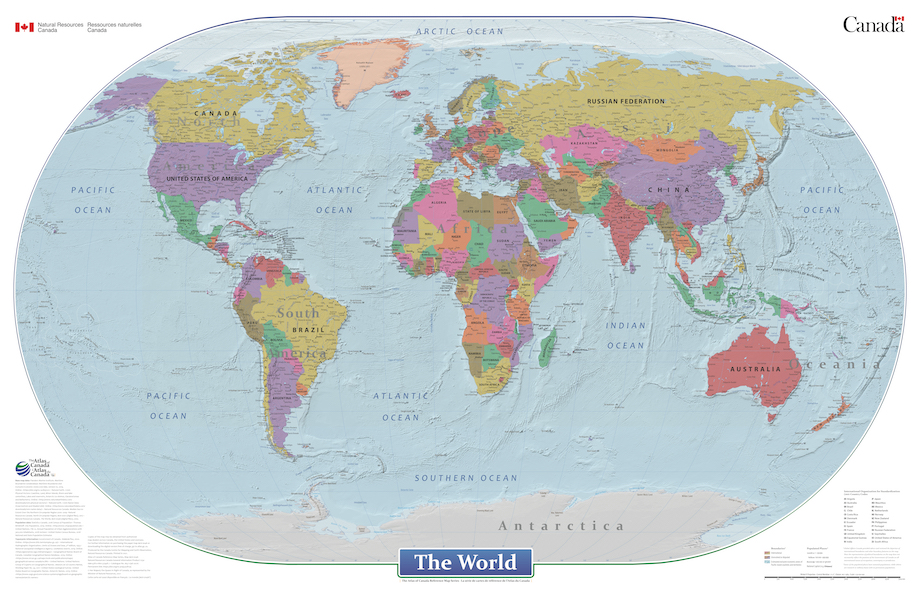
This cartographic digital product is derived from the Atlas of Canada's wall map "The World" (MCR 0046) and "Le monde" (MCR 0046F) published in 2021. The World is a general reference political map focused on the names and international boundaries of sovereign and non-sovereign countries. The information is portrayed using the Winkel II projection at a scale of 1:29 000 000. The dataset includes international boundaries, populated places, and labelled major hydrographic and physical features. In the geodatabase the representation of political boundaries do not necessarily reflect the position of the Government of Canada on all international issues of recognition, sovereignty or jurisdiction; some of the populated places have seasonal populations, while others are research or military bases with no permanent populations; and, there are no attribute information in the geodatabase for the labelled hydrographic and physical features.
-
Global phytoplankton production monthly maps for 2017 are produced using an artificial neural network to perform a generalized nonlinear regression of PP on several predictive variables, including latitude, longitude, day length, MLD, SST, PBopt computed according to Behrenfeld and Falkowski (1997), PAR and CHL(0 m). More details about this model can be found in Scardi (2001). Behrenfeld, M. J., Falkowski, P. G. (1997), Photosynthetic rates derived from satellite-based chlorophyll concentration, Limnology & Oceanography, 42(1), 1–20. Scardi, M. (2001), Advances in neural network modeling of phytoplankton primary production, Ecological Modelling, 146, 33–45.
-

IS: Samsettar og uppréttar sögulegar loftmyndir af Íslandi. Unnið er að því að staðsetja loftmyndir frá 1974 – 2000 úr loftmyndasafni Náttúrufræðistofnunar (https://gatt.lmi.is/geonetwork/srv/ice/catalog.search#/metadata/d2323e18-ab9f-495d-8a4e-58c2a5fb096e ). Myndirnar eru birtar jafnóðum og búið er að staðsetja þær en ætlunin er að staðsetja eldri myndir síðar. Svæði af myndum sem teknar voru í sama flugi og úr sömu flughæð eru sett saman. Upplausn myndanna er yfirleitt 50 cm. Búið er að vinna myndirnar með sjálfvirkum aðferðum. Ákveðnar staðsetningar eru valdar af gervitunglamyndum (https://gatt.lmi.is/geonetwork/srv/ice/catalog.search#/metadata/e542c260-6431-48a5-8065-93350b8cb3a1) og stilltar af á ÍslandsDEM landhæðalíkaninu (https://gatt.lmi.is/geonetwork/srv/ice/catalog.search#/metadata/e6712430-a63c-4ae5-9158-c89d16da6361 ). Áætluð staðsetningarnákvæmni myndanna er minna en 2 m. Heimild: Náttúrufræðistofnun. Uppréttar sögulegar loftmyndir frá 1974 - 2000. Dagsetning myndar. loftmyndasja.gis.is. [Loftmynd]. EN: This repository includes orthorectified and mosaicked historical aerial images from all over Iceland. The datasets are created from historical aerial images on film from the years 1974 - 2000 from the aerial photograph collection of the NLSI (https://gatt.lmi.is/geonetwork/srv/ice/catalog.search#/metadata/d2323e18-ab9f-495d-8a4e-58c2a5fb096e). Each mosaic is created from images taken on the same day at approximately the same height. The resolution of the mosaics is usually 50 cm. The historical photographs have been processed using automated methods of detection of points of interest using the Maxar mosaic (https://gatt.lmi.is/geonetwork/srv/ice/catalog.search#/metadata/e542c260-6431-48a5-8065-93350b8cb3a1)) followed by a refined correction of the cameras using the IslandsDEM (https://gatt.lmi.is/geonetwork/srv/ice/catalog.search#/metadata/e6712430-a63c-4ae5-9158-c89d16da6361) as reference. The estimated horizontal accuracy of the orthorectified aerial imagery is better than 2 meters. Citation: Natural Science Institute of Iceland [Náttúrufræðistofnun]. Historical aerial image orthomosaics from 1974 - 2000 [Uppréttar sögulegar loftmyndir frá 1974 - 2000]. Imagery date. loftmyndasja.gis.is. [Aerial Imagery].
-
This map is designed to be used as a basemap by GIS professionals and as a reference map by anyone. The map includes administrative boundaries, cities, water features, physiographic features, parks, landmarks, highways, roads, railways, and airports overlaid on land cover and shaded relief imagery for added context. The map provides coverage for the world down to a scale of ~1:72k. Coverage is provided down to ~1:4k for the following areas: Australia and New Zealand; India; Europe; Canada; Mexico; the continental United States and Hawaii; South America and Central America; Africa; and most of the Middle East. Coverage down to ~1:1k and ~1:2k is available in select urban areas. This basemap was compiled from a variety of best available sources from several data providers, including the U.S. Geological Survey (USGS), U.S. Environmental Protection Agency (EPA), U.S. National Park Service (NPS), Food and Agriculture Organization of the United Nations (FAO), Department of Natural Resources Canada (NRCAN), GeoBase, Agriculture and Agri-Food Canada, Garmin, HERE, Esri, OpenStreetMap contributors, and the GIS User Community. For more information on this map, including the terms of use, visit us <a href="http://goto.arcgisonline.com/maps/World_Topo_Map " target="_new" >online</a>.
-
This map is in <a href="http://links.esri.com/agol_lifecycle " target="_new" >Extended Support</a> and is no longer updated. Esri recommends that you use <a href="http://goto.arcgisonline.com/maps/World_Street_Map " target="_new" >World_Street_Map</a> instead (ArcGIS 9.3 or higher is required).
-

[IS] Náttúrufræðistofnun heldur utan um kontrólpunkta sem er settir niður til að staðsetja loftmyndir. Í flestum tilfellum er um ræða hvíta ferningar sem eru 60x60 sm, en á jöklum eru þeir bleikir. Þar sem ekki er hægt að setja niður kontólpunkta í formi ferninga er miðað við aðra fasta punkta í landslaginu. X, Y nákvæmni: 2-3 sm Hæðarnákvæmni: 3-5 sm Fitjueigindir, útskýringar: efni_raun: Lýsir gerð punktsins (Náttúrulegur punktur, Gúmmímotta, Málað, Suðuplast, Bleik plata). Eiginleiki mynd sýnir hvað er mælt, almennt miðjan á hlutnum nema annað sé tekið fram á myndinni. austur_maelt: Austur-hnit í ISN2016 EPSG:8088 nordur_maelt: Norður-hnit í ISN2016 EPSG:8088 ish_haed_maelt: ish2004 hæð sporvolu_haed_maelt: Hæð yfir ellipsoíð dagsetning_maelt: Mælingardagur mynd: Hlekkur á mynd af punktinum (ef tiltækt) maeli_adferd: Mæliaðferð, hvort sem er RTK eða FastStatic [EN] This dataset contains ground control points placed by the Icelandic Institute for Nature Research that can be used for aerial imagery geolocation. Normally white squares of 60x60cm or natural objects or pink squares 60x60cm on glaciers. X, Y Precision: 2-3 cm Elevation precision: 3-5 cm Properties description: efni_raun: describes the type of point (Natual point, Rubber mat, Painted, Welded plastic, Pink plate), the property mynd shows what is measured, generally the center of the object if not indicated differently in the image. austur_maelt: easting in ISN2016 EPSG:8088 nordur_maelt: northing in ISN2016 EPSG:8088 ish_haed_maelt: ish2004 elevation sporvolu_haed_maelt: ellipsoidal height dagsetning_maelt: date of measurement mynd: link to the image of the point (if available) maeli_adferd: Measurement method if RTK or FastStatic
-
This worldwide street map presents highway-level data for the world. Street-level data includes the United States; much of Canada; Mexico; Europe; Japan; Australia and New Zealand; India; South America and Central America; Africa; and most of the Middle East. This comprehensive street map includes highways, major roads, minor roads, one-way arrow indicators, railways, water features, administrative boundaries, cities, parks, and landmarks, overlaid on shaded relief imagery for added context. The map also includes building footprints for selected areas. Coverage is provided down to ~1:4k with ~1:1k and ~1:2k data available in select urban areas. The street map was developed by Esri using Esri basemap data, Garmin basemap layers, U.S. Geological Survey (USGS) elevation data, Intact Forest Landscape (IFL) data for the world; HERE data for Europe, Australia and New Zealand, North America, South America and Central America, Africa, India, and most of the Middle East; OpenStreetMap contributors for select countries in Africa and Pacific Islands; NGCC data for China; and select data from the GIS user community. For more information on this map, including the terms of use, visit us <a href="http://goto.arcgisonline.com/maps/World_Street_Map " target="_new" >online</a>.