 Arctic SDI catalogue

chsinfo@dfo-mpo.gc.ca
Type of resources
Available actions
Topics
Keywords
Contact for the resource
Provided by
Formats
Representation types
Update frequencies
status
-

Canadian Hydrographic Service (CHS) has made available all the publishable limits of modern day surveys whose data has been collected since 1989.
-

With this update the Canadian Hydrographic Service (CHS) offers both a complete inventory of bathymetric data free to the public for non-navigational as well as, for the first time, a collection of intensity image data products. To meet a growing desire in the scientific, commercial, environmental, and Indigenous communities for backscatter intensity data, the Canadian Hydrographic Service (CHS) has embarked on a Pilot Project to produce and distribute intensity imagery products from our current multibeam echo sounder (MBES) and LiDAR data holdings. MBES and LiDAR sensors collect two types of data, seafloor depth and backscatter intensity. The seafloor depth, or bathymetry is well represented on the CHS NONNA Data Portal. These products are available in a spatial resolution of 10 metres or 100 metres. While typically outside of our primary focus on bathymetry and charting for safe navigation, the CHS recognizes the importance of intensity data for the purposes of environmental and ecosystem management as well as the economic benefits associated with increased understanding of our marine environment. Backscatter intensity data, recorded in decibels (dB) is a measure of the strength of the return of a MBES pulse from the ocean floor to the multibeam receiver. These measures may be visualized as grey scale intensity map imagery. Backscatter intensity imagery can provide researchers with information about the surficial geology of the seafloor or objects on it. For example, hard, rocky materials will reflect more sound energy than softer materials such as mud. To be clear, the CHS is not attempting to create fully normalized and ground-truthed backscatter products. The CHS’s intensity and reflectance data holdings may be best understood as ‘collateral’ data encoded within the raw datagrams collected during MBES & LiDAR bathymetric surveys. **NEW** CHS NONNA INTENSITY A CHS NONNA Intensity product package is a ZIP file containing either an ASCII (x.y,dB) and/or a GEOTIFF image (w. intensity band) and the available metadata file. Variations in Intensity product resolution and quality are dependent on the contributing source data. TERMS OF USE To directly access the CHS NONNA Data Portal please follow this link - https://data.chs-shc.ca/login (Note: The data portal is NOT compatible with Internet Explorer browser). The Canadian Hydrographic Service (CHS) NONNA Data products are for NON-NAVIGATIONAL USE ONLY. Please see the Open Data Licence below and the CHS NONNA LICENCE viewable on https://data.chs-shc.ca/login and downloadable with the NONNA data, for the full terms and conditions governing the use of this data. ----- PRODUCT DESCRIPTION ----- The « NONNA » refers to the NON-Navigational nature of the data. Intensity data products contain NO depth information and as such are COMPLETELY UNSUITABLE FOR NAVIGATIONAL PURPOSES. The CHS NONNA Intensity Data products are packaged as a ZIP file containing an ASCII and/or GEOTIFF image dataset and a related metadata file. Resolution for data sources varies from data sources to data source and is dependent on the resolution of the source data it was derived from. The Intensity data supplied will be from various survey platforms, using a variety of MBES systems over the full extent of the CHS’s implementation of MBES and LiDAR surveying. All survey data provided will have been collected and processed to CHS data acquisition standards, which is to say these data were COLLECTED FOR THE EXPRESS PURPOSE OF SAFETY OF NAVIGATION and the need to maintain and update sounding data for CHS charts. Best practices for collecting MBES bathymetric data are not necessarily best practices for surveys where the express purpose is the production of intensity data products. As such, the data in our Archives may not have been collected to a standard best suited for producing high quality intensity data products. ----- DATUM ----- All CHS NONNA data sources are horizontally referenced to the World Geodetic System 1984 (WGS84) ESPG4326. CHS NONNA Intensity products contain no depth values and as such require no vertical reference. ----- DATA PRESENTATION ----- CHS NONNA Intensity products adhere to a different naming convention than the CHS NONNA Bathymetric products. Each product name has an unique ID that references the lineage of the contributing hydrographic source. Each contributing source is a hydrographic survey conducted by a single vessel using a single MBES. These products are available to view, query and download via the CHS NONNA Data Portal. The CHS NONNA Intensity products are ZIP files that contain product coverage (at varying resolution). The following formats are available for download: • 32-bit GeoTIFF • ASCII (XYI) These formats can be opened using a wide variety of GIS applications. *NOTE:* Gaps in the data may be visible where modern surveys have not yet been conducted, the data is not updated to Chart Datum (CD) or where legacy data has not yet been digitized. In addition, there may be data sources removed from the CHS NONNA Data Portal for further processing in the CHS’ Bathymetric Database, and as such, these datasets will not be available until such work is complete. Our investigation has uncovered existing intensity data products in our Archives that will be available for distribution immediately. However, there is a wealth of intensity near to completion. CHS NONNA Intensity products will be published as they become available. Data sources included in the CHS NONNA products may not have been subjected to the same level of quality assurance as those in official navigational products. *HELP* New users of the CHS NONNA Data Portal are encouraged to fully review the 'CHS NONNA Data Portal Guidance Document' (PDF) which is available below in the RESOURCES section of this page. • Publisher - Current Organization Name: Fisheries and Oceans Canada • Licence: Open Government Licence - Canada
-

Canadian Anchorages and Anchorage Areas is comprised of four shapefiles which include anchorage areas (ACHARE) and single ship anchorages (ACHBRT). The shapefiles are either one with points and one with polygons for each of the two types of anchorages. These files are a comprehensive dataset of anchorages and anchorage areas in Canadian navigable waters. This dataset will be updated as needed.
-

CHS offers 500-metre bathymetric gridded data for users interested in the topography of the seafloor. This data provides seafloor depth in metres and is accessible for download as predefined areas.
-

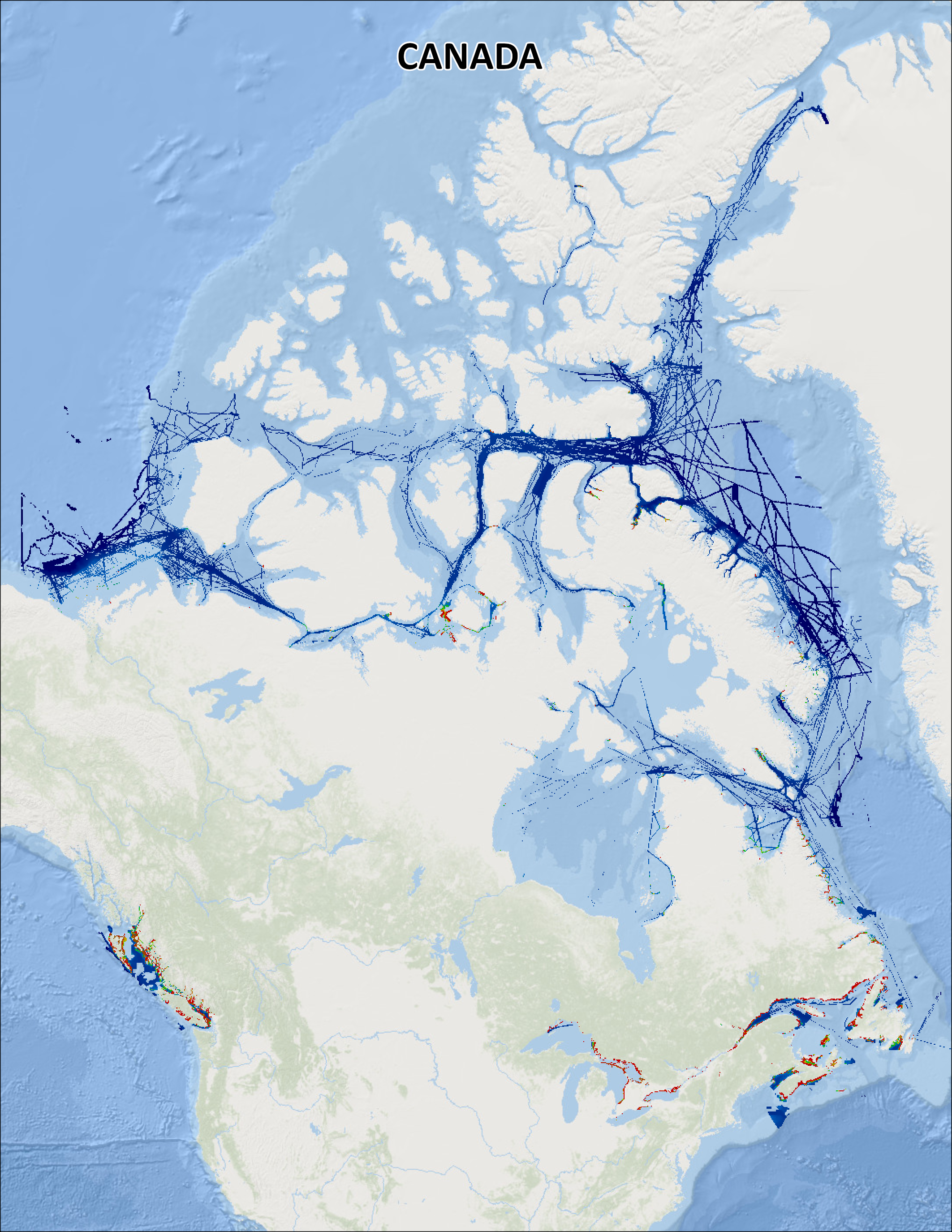
Canadian tides and water level station information, benchmarks, observed water level data, and tidal predictions. The Canadian tide and water level data archive presently holds water level observations reported from over a thousand stations, with the earliest dating back to 1848. The number of observations spans on average 6 years per station, with 60 stations measuring water levels for over 50 years. Over 800 stations are subjected to appreciable effect of tides, and for most of these stations, the Canadian Hydrographic Service (CHS) calculates and publishes predictions of the water levels associated with the vertical movement of the tide. Observations from the CHS Permanent Water Level Network are added on a daily to monthly basis. Data are also exchanged annually with the Water Survey of Canada. Each point in the map represents a station with links to observations, tidal predictions, and benchmark information, where available.
-
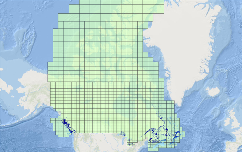
**CHS NONNA Data Portal was last updated: March 30, 2025 ** The Canadian Hydrographic Service (CHS) offers a complete inventory of bathymetric data free to the general public for non-navigational use called 'CHS NONNA' for the 'NON-NAvigational' purpose of the data. The product is available in a spatial resolution of 10 metres or 100 metres. To directly access the CHS NONNA Data Portal please follow this link - https://data.chs-shc.ca/login (Note: The data portal is NOT compatible with Internet Explorer browser). Terms of Use The Canadian Hydrographic Service (CHS) NONNA Data products are for NON-NAVIGATIONAL USE ONLY. Please see the Open Data Licence below and the CHS NONNA LICENCE viewable on https://data.chs-shc.ca/login and downloadable with the NONNA data, for the full terms and conditions governing the use of this data. ----- PRODUCT DESCRIPTION ----- The CHS NONNA-10 NONNA-100 and NONNA Package Bathymetric Data products represent a consolidation of digital bathymetric sources managed by the CHS in Canadian jurisdiction. The « NONNA » refers to NON-NAvigational. The « 10 » or « 100 » references the approximate resolution (in metres) of the data. NONNA Packages A NONNA Package is a ZIP file containing a collection of NONNAP datasets to ease the download of large amounts of high resolution data. Packages are currently available for data sources of approximately 10 metre resolution. The «P10 » refers to the Packages and approximate resolution (in metres) of the data. The CHS NONNA-10 individual product coverage (resolution) is as follows: • South of 68°N the products = 0.1° latitude X 0.1° longitude (0.0001 degrees) • 68°N-80°N the products = 0.1° latitude X 0.2° longitude (0.0002 degrees) • 80°N and north the products = 0.1° latitude X 0.4° longitude (0.0004 degrees) The CHS NONNA-100 individual product coverage (resolution) is as follows: • South of 68°N the products = 1° latitude X 1° longitude (0.001 degrees) • 68°N-80°N the products = 1° latitude X 2° longitude (0.002 degrees) • 80°N and north the products = 1° latitude X 4° longitude (0.004 degrees) The CHS NONNA-P10 Packages are ZIP files that contain product coverage (resolution) defined as: • South of 68°N the products = 1° latitude X 1° longitude (0.0001 degrees) • 68°N-80°N the products = 1° latitude X 2° longitude (0.0002 degrees) • 80°N and north the products = 1° latitude X 4° longitude (0.0004 degrees) ----- DATUM ----- All CHS NONNA data sources are horizontally referenced to the World Geodetic System 1984 (WGS84) ESPG:4326 and vertically referenced to Chart Datum (CD), a tidal or water level datum that is locally derived and, of which, the depth of water should seldom fall below. For more information on vertical references visit: https://tides.gc.ca/tides/en/vertical-datum-chart-references ----- DATA PRESENTATION ----- CHS NONNA products adhere to the following naming convention: NONNAXXX_SouthwestCorner Example: NONNAP10_4360N07940W • NONNAP10 = the product NONNAP10 • 4360N07940W = the southwest corner of the NONNA cell. These products are available to view, query and download via the CHS NONNA Data Portal. The following formats are available for download: • 32-bit GeoTIFF • ASCII++ (XYZ) • CSAR • BAG These formats can be opened using various GIS applications. Alternatively, the CHS NONNA products can be accessed via Web Map Service (WMS), Web Coverage Service (WCS) or Web Map Tile Service (WMTS) links: WMS https://nonna-geoserver.data.chs-shc.ca/geoserver/wms?request=GetCapabilities WMTS https://nonna-geoserver.data.chs-shc.ca/geoserver/gwc/service/wmts?request=GetCapabilities WCS https://nonna-geoserver.data.chs-shc.ca/geoserver/wcs?request=GetCapabilities *Note* Gaps in the data may be visible where modern surveys have not yet been conducted, the data is not updated to Chart Datum (CD) or where legacy data has not yet been digitized. In addition, there may be data sources removed from the Data Portal for further processing in the CHS’ Bathymetric Database, and will not be available until such work is complete. Data sources included in the NONNA products may not have been subjected to the same level of quality assurance as those in official navigational products. *Help* New users of the CHS NONNA Data Portal are encouraged to fully review the 'CHS NONNA Data Portal Guidance Document' (PDF) which is available below in the RESOURCES section of this page.
-

This service provides routeing measures. These include established (mandatory) direction of traffic flow, recommended direction of traffic flow, separation lines, separation zones, limits of restricted routeing measure, limits of routeing measures, precautionary areas, archipelagic sea lanes (axis line and limit beyond which vessels shall not navigate) and fairways designated by regulatory authority.
-
CHS offers 500-metre bathymetric gridded data for users interested in the topography of the seafloor. This data provides seafloor depth in metres and is accessible for download as predefined areas.
-

This service provides a compilation of Electronic Navigational Charts (ENC) produced by the Canadian Hydrographic Service. All information provided by this service conforms to the International Hydrographic Organization (IHO) Publication S-57. An ENC contains all the chart information useful for navigation, and may contain supplementary information in addition to that contained in the paper chart. This service is not for navigation.