 Arctic SDI catalogue
2020 3.6.7
Type of resources
Available actions
Topics
Keywords
Contact for the resource
Provided by
Years
Formats
Scale
Resolution
-
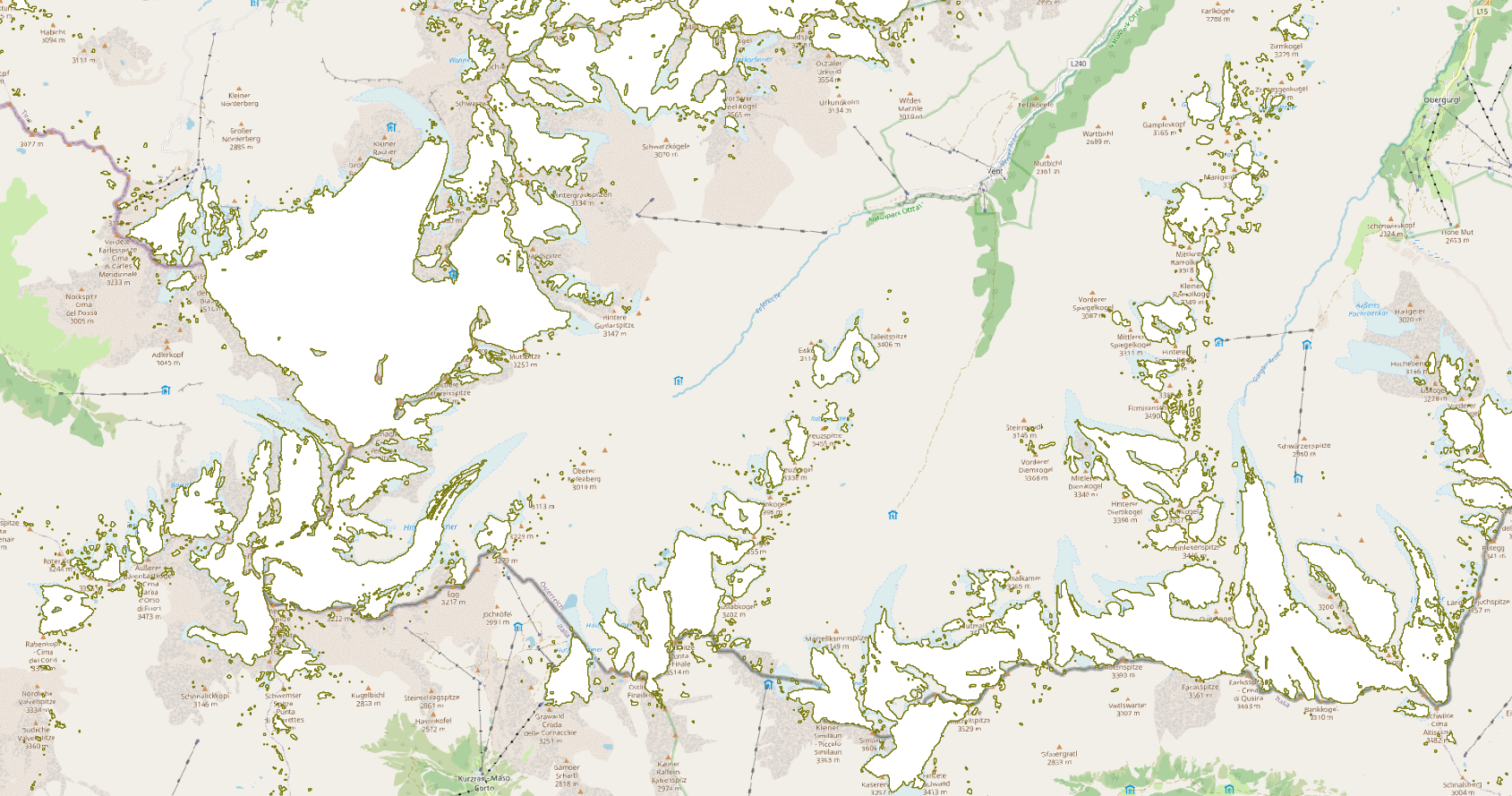
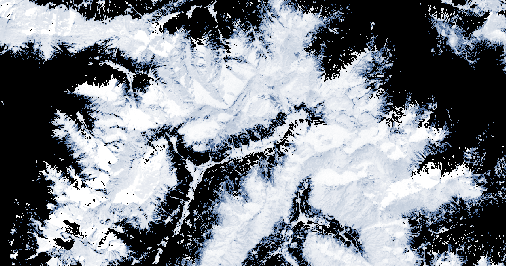
The Copernicus Persistent Snow Area (PSA) product is generated annually for the entire EEA38 and the United Kingdom, based on the Fractional Snow Cover (FSC) information. It provides the extent of the persistent snow cover, i.e. the area where snow is present throughout the hydrological year with a spatial resolution of 20 m x 20 m. This metadata refers to the PSA product distributed in raster files as tiles aligned with Sentinel-2 (UTM/WGS84) at 20 m x 20 m GSD. It is also available in another projection as tiles aligned with the Pan-European High-Resolution Layers in the European 20 m x 20 m grid (ETRS89 LAEA - EPSG: 3035). It is typically released on an annual basis with a release date in October, after the end of the hydrological year. Each product is composed of two separate files corresponding to the different layers of the product, and another metadata file. PSA is one of the products of the pan-European High-Resolution Snow & Ice service (HR-S&I), which are provided at high spatial resolution (20 m x 20 m and 60 m x 60 m), from the Sentinel-2 and Sentinel-1 constellations data from September 1, 2016 to September 1, 2024.
-

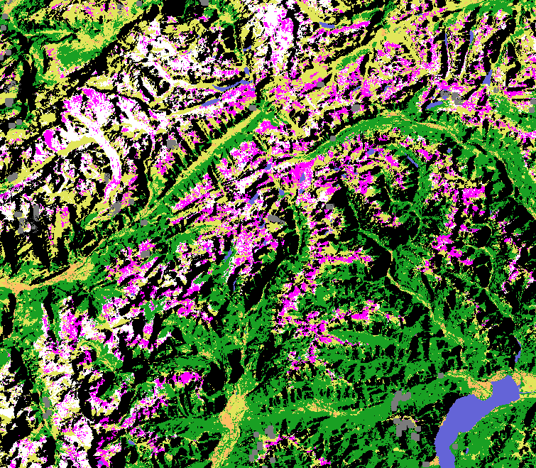
The HRL Small Woody Features (SWF) is a new Copernicus Land Monitoring Service (CMLS) product, which provides harmonized information on linear structures such as hedgerows, as well as patches (200 m² ≤ area ≤ 5000 m²) of woody features across the EEA39 countries. Small woody landscape features are important vectors of biodiversity and provide information on fragmentation of habitats with a direct potential for restoration while also providing a link to hazard protection and green infrastructure, amongst others. The SWF layer contains woody linear, and small patchy elements, but is not differentiated into trees, hedges, bushes and scrub. The spatial pattern are limited to linear structures and isolated patches (patchy structures) on the basis of geometric characteristics. Additional Woody Features (AWF) are also included in this product. They consist of woody structures that do not fulfil the SWF geometric specifications but which are connected to valid SWFs structures. VHR imagery (DEIMOS-2, Pleiades 1A, Pleiades 1B, GeoEye-1, SPOT 6, SPOT 7, WorldView-2, WorldView-3 images from 2015) made available in the ESA Copernicus DWH are the main data source for the detection of small woody features identifiable within the given image resolution. The dataset is available for the 2015 reference year and is produced in three different formats. This metadata corresponds to the SWF 100m spatial resolution raster aggregate layers: SWF density (0 – 100 %), AWF density (0 – 100 %) and SWF+AWF density (0 – 100 %). The SWF 100m raster layer, consistent with the EEA 100m grid, is a 100m aggregated version of the SWF 5m raster layer. It can be used as a landscape descriptor of SWF density for large areas.
-
The HRL Small Woody Features (SWF) is a new Copernicus Land Monitoring Service (CMLS) product, which provides harmonized information on linear structures such as hedgerows, as well as patches (200 m² ≤ area ≤ 5000 m²) of woody features across the EEA39 countries. Small woody landscape features are important vectors of biodiversity and provide information on fragmentation of habitats with a direct potential for restoration while also providing a link to hazard protection and green infrastructure, amongst others. The SWF layer contains woody linear, and small patchy elements, but is not differentiated into trees, hedges, bushes and scrub. The spatial pattern are limited to linear structures and isolated patches (patchy structures) on the basis of geometric characteristics. Additional Woody Features (AWF) are also included in this product. They consist of woody structures that do not fulfil the SWF geometric specifications but which are connected to valid SWFs structures. VHR imagery (DEIMOS-2, Pleiades 1A, Pleiades 1B, GeoEye-1, SPOT 6, SPOT 7, WorldView-2, WorldView-3 images from 2015) made available in the ESA Copernicus DWH are the main data source for the detection of small woody features identifiable within the given image resolution. The dataset is available for the 2015 reference year and is produced in three different formats. This metadata corresponds to the SWF vector layer, which separates the SWF class into Linear (code = 1) and Patchy (code = 2). Additional Woody Features are represented with code = 3. This is the primary product of the Small Woody Features mapping, and thus also the one with most detail. The vector data set can be downloaded in Geodatabase and Geopackage formats.
-

The HRL Small Woody Features (SWF) is a new Copernicus Land Monitoring Service (CMLS) product, which provides harmonized information on linear structures such as hedgerows, as well as patches (200 m² ≤ area ≤ 5000 m²) of woody features across the EEA39 countries. Small woody landscape features are important vectors of biodiversity and provide information on fragmentation of habitats with a direct potential for restoration while also providing a link to hazard protection and green infrastructure, amongst others. The SWF layer contains woody linear, and small patchy elements, but is not differentiated into trees, hedges, bushes and scrub. The spatial pattern are limited to linear structures and isolated patches (patchy structures) on the basis of geometric characteristics. Additional Woody Features (AWF) are also included in this product. They consist of woody structures that do not fulfil the SWF geometric specifications but which are connected to valid SWFs structures. VHR imagery (DEIMOS-2, Pleiades 1A, Pleiades 1B, GeoEye-1, SPOT 6, SPOT 7, WorldView-2, WorldView-3 images from 2015) made available in the ESA Copernicus DWH are the main data source for the detection of small woody features identifiable within the given image resolution. The dataset is available for the 2015 reference year and is produced in three different formats. This metadata corresponds to the SWF 5m spatial resolution raster layer, which distinguishes between SWF (code =1) and AWF (code =3) ). This layer is derived from the SWF vector product in order to be more in line with other HR layers, and for allowing raster processing of the results. It describes the SWF landscape according to the high resolution of the input data, but without taking into account the possible small geometric inaccuracy of the vector product (due to VHR geometric imprecision, automatic processing such as smoothing, etc.). The geometric resolution is consistent with the EEA reference grid.
-
The Copernicus Daily Cumulative Gap-filled Fractional Snow Cover (GFSC) product is generated in near real-time for the entire EEA38 and the United Kingdom, based on radar satellite data from the Sentinel-1 constellation and on optical data from the Sentinel-2 constellation. The product uses Copernicus FSC (Fractional Snow Cover), WDS (Wet/Dry Snow) and SWS (SAR Wet Snow) products along with DEM data as input to form a spatially complete composite of snow conditions, to reduce observational gaps due to clouds and lack of sensor coverage on a daily basis. The product provides the extent of the snow cover per pixel as a percentage (0% – 100%) with a spatial resolution of 60 m x 60 m. The GFSC product is distributed in raster files covering an area of 110 km by 110 km with a pixel size of 60 m by 60 m in UTM/WGS84 projection, which corresponds to the Sentinel-2 input L1C product tile. Each product is composed of four separate GeoTIFF files corresponding to the different layers of the product, and a metadata file. The GF layer provides the gap-filled fractional snow cover, while the QC layers (AT, QCFLAGS, QC) provide information on the quality of the GF layer at the pixel level . The GFSC is one of the products of the pan-European High-Resolution Snow & Ice service (HR-S&I), which are provided at high spatial resolution (20 m x 20 m and 60 m x 60 m), from the Sentinel-2 and Sentinel-1 constellations data from September 1, 2016 onwards.
-
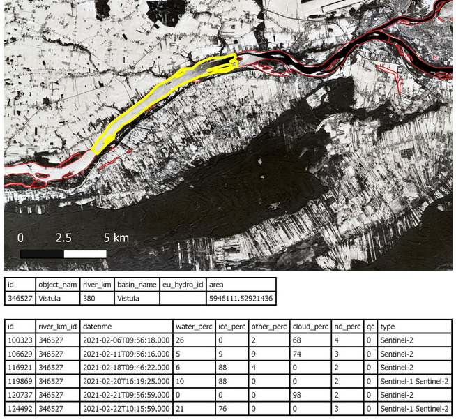
The Aggregated River and Lake Ice Extent (ARLIE) product is a spatially aggregated information on surface water conditions of rivers and lakes. ARLIE information is stored in a geodatabase, enriched every day from the different River and Lake Ice Extent products (RLIE S1, RLIE S2, RLIE S1+S2) for the entire EEA38 and the United Kingdom. It provides percent coverage of snow-covered or snow-free ice on lakes and on 10 km river sections described by the EU-HYDRO river and lake network database. The ARLIE data is stored in a PostGIS persistent geodatabase. They can be retrieved by using a specific REST API. Users can query ice sheet summary information of river segments and lakes (ARLIE statistics) together with the geometry and caracteristics of the features on which these statistics were estimated. All geometry features are delivered in the ETRS89 LAEA (EPSG:3035) coordinate reference system. ARLIE is one of the products of the pan-European High-Resolution Snow and Ice service (HR-S&I), which are provided at high spatial resolution from the Sentinel-2 and Sentinel-1 constellations data from September 1, 2016 onwards.
-
The Copernicus Fractional Snow Cover (FSC) product is generated in near real-time for the entire EEA38 and the United Kingdom, based on optical satellite data from the Sentinel-2 constellation. The product provides the fraction of the surface covered by snow at the top of canopy (FSC-TOC) and on ground (FSC-OG) per pixel as a percentage (0% – 100%) with a spatial resolution of 20 m x 20 m. FSC is one of the products of the pan-European High-Resolution Snow & Ice service (HR-S&I), which are provided at high spatial resolution (20 m x 20 m and 60 m x 60 m), from the Sentinel-2 and Sentinel-1 constellations data from September 1, 2016 onwards. The FSC product is distributed in raster files covering an area of 110 km by 110 km with a pixel size of 20 m by 20 m in UTM/WGS84 projection, which corresponds to the Sentinel-2 input L1C product tile. Each product is composed of seven separate files corresponding to the different layers of the product, and another metadata file.
-
The Copernicus Wet/Dry Snow (WDS) product is generated in near real-time for the entire EEA38 and the United Kingdom, based on radar satellite data from the Sentinel-1 constellation. The product differentiates the snow state conditions within the snow mask defined by the FSCTOC information (snow fraction at the top of canopy - see the Copernicus Fractional Snow Cover product) with a spatial resolution of 60 m x 60 m. In other words, it provides a binary discrimination of wet and dry snow, identifying patchy snow or snow free areas. The WDS product is distributed in raster files covering an area of 110 km by 110 km with a pixel size of 60 m by 60 m in UTM/WGS84 projection, which corresponds to the Sentinel-2 input L1C product tile. Each product is composed of two separate GeoTIFF files corresponding to the different layers of the product (the snow state classification -SSC- and the associated quality layer -QCSSC-) and a metadata file. The WDS is one of the products of the pan-European High-Resolution Snow & Ice service (HR-S&I), which are provided at high spatial resolution (20 m x 20 m and 60 m x 60 m), from the Sentinel-2 and Sentinel-1 constellations data from September 1, 2016 onwards.
-
The Aggregated Water and Ice (AWIC) product is a spatially aggregated information on surface water conditions of rivers and lakes. AWIC information is stored in a geodatabase, enriched every day from the different Water/Ice Cover products (WIC S1, WIC S1, WIC S1+S2) for the entire EEA38 and the United Kingdom. It provides percent coverage of snow-covered or snow-free ice on lakes and on 10 km river sections described by the EU-HYDRO river and lake network database. AWIC data is stored in a PostGIS persistent geodatabase. They can be retrieved by using a specific REST API. Users can query ice sheet summary information of river segments and lakes (AWIC statistics) together with the geometry and caracteristics of the features on which these statistics were estimated. All geometry features are delivered in the ETRS89 LAEA (EPSG:3035) coordinate reference system. AWIC is one of the products of the pan-European High-Resolution Water, Snow and Ice service (HR-WSI), which are provided at high spatial resolution from the Sentinel-2 and Sentinel-1 constellations data from September 1, 2016 onwards.
-

The Copernicus SAR Wet Snow (SWS) product is generated in near real-time for the entire EEA38 and the United Kingdom, based on radar satellite data from the Sentinel-1 constellation. The product provides binary information on the wet snow extent and the snow free or patchy snow or dry snow extent in high mountain areas with a spatial resolution of 60 m x 60 m. The SWS product is distributed in raster files covering an area of 110 km by 110 km with a pixel size of 60 m by 60 m in UTM/WGS84 projection, which corresponds to the Sentinel-2 input L1C product tile. It is available in several mountainous regions in Iceland, the Pyrenees, the Alps, Eastern Türkiye and Scandinavia. Each product is composed of two separate GeoTIFF files corresponding to the different layers of the product, and a metadata file.The WSM (Wet Snow classification in high Mountainous areas) layer provides the wet snow extent derived from S1 Level 1 GRD data over high montainous areas, and the QCWSM (Quality) layer provides the per-pixel accuracy information associated with the WSM layer for all pixels with detected snow areas. The SWS is one of the products of the pan-European High-Resolution Snow & Ice service (HR-S&I), which are provided at high spatial resolution (20 m x 20 m and 60 m x 60 m), from the Sentinel-2 and Sentinel-1 constellations data from September 1, 2016 onwards.