 Arctic SDI catalogue
Assess Toxicity, Manage and Monitor for Environmental Presence of Hazardous Substances and Waste
Type of resources
Available actions
Topics
Keywords
Contact for the resource
Provided by
Formats
Representation types
Update frequencies
status
-

Monitoring activities have collected bulk suspended sediment samples using continuous flow centrifuges and Phillips Tube samplers in the Lower Athabasca River and tributaries respectively. Further, in the absence of pre-development monitoring for this region, high fidelity dated lake sediment cores were used to assess the natural range in contaminant deposition to this region and to obtain a historical perspective of contaminant loadings. All sediments (suspended river and lake cores) have been analyzed in the laboratory for sediment quality variables as per Appendix B in the Integrated Monitoring Plan (cores were also analyzed for paleo indicators of ecosystem health such as diatoms). In addition, as the Lower Athabasca river bed sediments are known to shift and migrate downstream, bathymetric maps of the bed-channel morphology over time was also completed. This will allow for estimates of bed sediment transport downstream for the period of survey, and be useful in calibration/validation of sediment and contaminant numerical transport models.
-
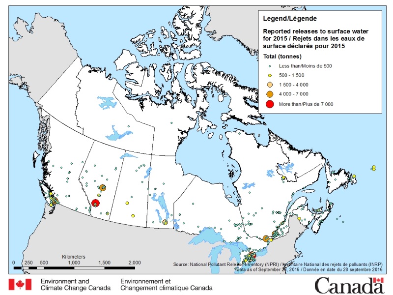
The National Pollutant Release Inventory (NPRI) is Canada's public inventory of pollutant releases (to air, water and land), disposals and transfers for recycling. The files below contain a map of Canada showing the locations of all facilities that reported direct releases to surface waters to the NPRI. The data are for the most recent reporting year, by reported total quantities of these releases. The map is available in both ESRI REST (to use with ARC GIS) and WMS (open source) formats. For more information about the individual reporting facilities, a dataset is available in a CSV format. Please consult the following resources to enhance your analysis: - Guide on using and Interpreting NPRI Data: https://www.canada.ca/en/environment-climate-change/services/national-pollutant-release-inventory/using-interpreting-data.html - Access additional data from the NPRI, including datasets and mapping products: https://www.canada.ca/en/environment-climate-change/services/national-pollutant-release-inventory/tools-resources-data/exploredata.html
-
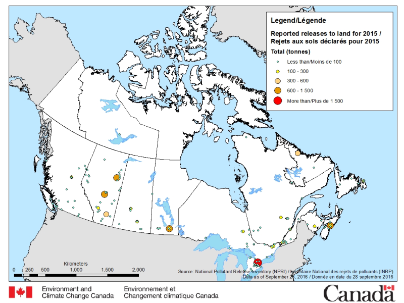
The National Pollutant Release Inventory (NPRI) is Canada's public inventory of pollutant releases (to air, water and land), disposals and transfers for recycling. The files below contain a map of Canada showing the locations of all facilities that reported direct releases to land to the NPRI. The data are for the most recent reporting year, by reported total quantities of these releases. The map is available in both ESRI REST (to use with ARC GIS) and WMS (open source) formats. For more information about the individual reporting facilities, a dataset is available in a CSV format. Please consult the following resources to enhance your analysis: - Guide on using and Interpreting NPRI Data: https://www.canada.ca/en/environment-climate-change/services/national-pollutant-release-inventory/using-interpreting-data.html - Access additional data from the NPRI, including datasets and mapping products: https://www.canada.ca/en/environment-climate-change/services/national-pollutant-release-inventory/tools-resources-data/exploredata.html
-

The National Pollutant Release Inventory (NPRI) is Canada's public inventory of pollutant releases (to air, water and land), disposals and transfers for recycling. Each file contains the NPRI map layers in a KMZ format that you can use with virtual globe software such as Google Earth™. Data are available for the last two reporting years. You can filter the data by province or industry type. Select a facility to view a report that summarizes its pollutant releases, disposals and transfers. Please consult the following resources to enhance your analysis: - Guide on using and Interpreting NPRI Data: https://www.canada.ca/en/environment-climate-change/services/national-pollutant-release-inventory/using-interpreting-data.html - Access additional data from the NPRI, including datasets and mapping products: https://www.canada.ca/en/environment-climate-change/services/national-pollutant-release-inventory/tools-resources-data/exploredata.html
-
Acid-Sensitive Lakes Nine hundred and thirty-three lakes located in Saskatchewan, Alberta and the Northwest Territories were sampled to establish current acidification status. Of the 933 lakes, 244 (or 26%) are considered acid sensitive, almost always because of naturally low calcium and magnesium (or "base cation") concentrations. The most acid-sensitive lakes (i.e., those with extremely low base cation concentrations) are located on the Canadian Shield in both Alberta and Saskatchewan and east of the oils sands development area. Fifty-one of the 244 acid-sensitive lakes were sampled twice annually (spring and fall) to identify chemical changes through trend analyses. Results revealed that 55% of these lakes had concentrations of some metals in excess of Canadian Council of Ministers of the Environment guidelines. Of the 291 samples taken in the 51 lakes, iron concentrations were greater than guidelines in 36% (105 samples), aluminum in 33% (97 samples), lead in 0.3% (1 sample) and copper in 0.3% (1 sample). The metals in these lakes occur naturally and are expected to be found in a wide range of concentrations given the geology and physiography of the Canadian Shield. It remains to establish the relationship between acid sensitivity, geology and high metal concentrations.
-
The Canadian Environmental Sustainability Indicators (CESI) program provides data and information to track Canada's performance on key environmental sustainability issues. The Water quality in Canadian rivers indicators provide a measure of the ability of river water across Canada to support plants and animals. At each monitoring site, water quality data are compared to water quality guidelines to create a rating for the site. If measured water quality is below the guidelines, it can maintain a healthy ecosystem. Water quality at a monitoring site is considered excellent when substances in a river are very rarely measured above their guidelines. Conversely, water quality is rated poor when measurements are usually above their guidelines, sometimes by a wide margin. These indicators provide information about the state of surface water quality and its change through time, to support water resource management. Information is provided to Canadians in a number of formats including: static and interactive maps, charts and graphs, HTML and CSV data tables and downloadable reports. See the supplementary documentation for the data sources and details on how the data were collected and how the indicator was calculated. Canadian Environmental Sustainability Indicators - Home page: https://www.canada.ca/environmental-indicators
-
The objectives of the fish component of the integrated oil sands monitoring program are to provide the necessary data/information to address key questions related to both environmental health of fish populations and fish health issues that can be used to inform human use and consumption. The questions underlying the fish monitoring design are related to the status and health of wild fish populations in the Lower Athabasca River including and in an expanded geographical extent. Data is being collected to provide a baseline against which future changes in fish populations will be evaluated, and compared to data from historical studies to assess change over time to the current state. Data is also being collected in areas of new oil sands development, to develop baseline data for future site-specific comparisons, contribute to an expanded geographic basis of the overall monitoring plan, and contribute to an improved ability to examine cumulative effects.
-
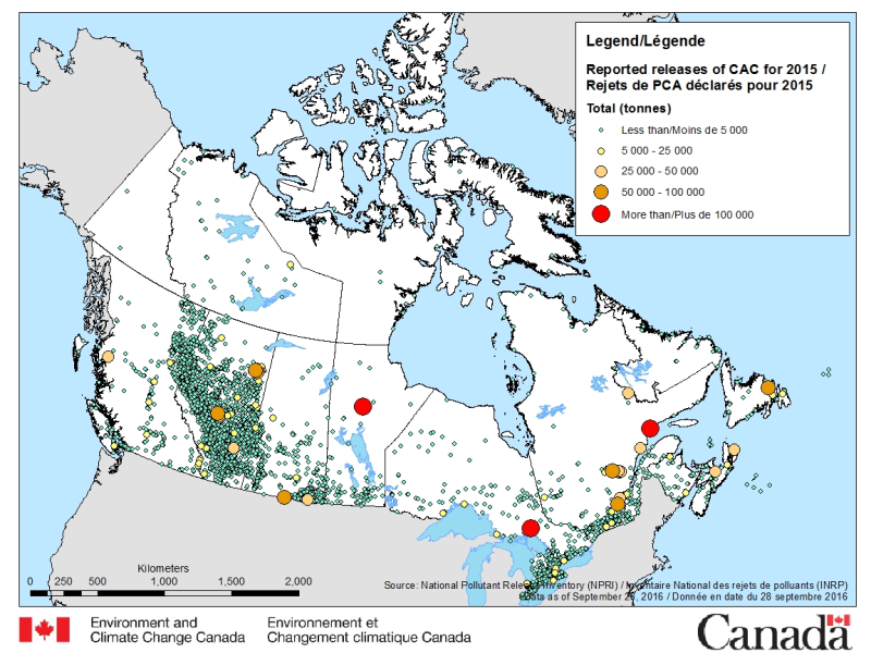
The National Pollutant Release Inventory (NPRI) is Canada's public inventory of pollutant releases (to air, water and land), disposals and transfers for recycling. The files below contain a map of Canada showing the locations of all facilities that reported direct releases of Criteria Air Contaminants to the NPRI. The data are for the most recent reporting year, by reported total quantities of these releases. The map is available in both ESRI REST (to use with ARC GIS) and WMS (open source) formats. For more information about the individual reporting facilities, a dataset is available in a CSV format. Please consult the following resources to enhance your analysis: - Guide on using and Interpreting NPRI Data: https://www.canada.ca/en/environment-climate-change/services/national-pollutant-release-inventory/using-interpreting-data.html - Access additional data from the NPRI, including datasets and mapping products: https://www.canada.ca/en/environment-climate-change/services/national-pollutant-release-inventory/tools-resources-data/exploredata.html
-
Assess the importance of atmospheric deposition of contaminants as a contributor to ecological impacts of oil sands development and identify sources. • Use snowpack measurements sampled across a gridwork to develop maps of winter-time atmospheric contaminant loadings for the region ~100 km from the major upgrading facilities • Assess long-term trends in winter-time atmospheric deposition • Determine the potential impact of wintertime snowpack mercury loads on tributary river water mercury concentrations (Spring Freshet) using Geographic Information System and hydrological modelling approaches • Compare snowpack loadings to those obtained from precipitation monitoring and compare spatial patterns to PAC air measurements obtained from passive sampling network All data are subjects of a publication containing method details, full QA/QC, interpretations and conclusions. Citations: A. Dastoor, A. Ryjkov, G. Kos, J. Zhang, J.L. Kirk, M. Parsons, A. Steffen. 2021. Impact of Athabasca oil sands operations on mercury levels in air and deposition. Atmospheric Chemistry and Physics 21, 12783-12807. L. Chibwe, D.C.G. Muir, Y. Gopalapillai, D. Shang, F. Yang, J.L. Kirk, C. Manzano, B. Atkinson, X. Wang, C. Teixeira. 2021. Long-term spatial and temporal trends, and source apportionment of polycyclic aromatic compounds in the Athabasca Oil Sands Region. Environmental Pollution 268A, 115351. J. Culp, I. Droppo, P. di Cenzo, A. Alexander-Trusiak, D. Baird, S. Beltaos, G. Bickerton, B. Bonsal, R. Brua, P. Chambers, Y. Dibike, N. Glozier, J.L. Kirk, L. Levesque, M. McMaster, D.C.G. Muir, J. Parrott, D. Peters, K. Pippy, J. Roy. 2021. Ecological effects and causal synthesis of oil sands activity impacts on river ecosystems: water synthesis review. Environmental Reviews 29. Doi: https://doi.org/10.1139/er-2020-0082. Y. Gopalapillai, J. L. Kirk, M.S. Landis, D.C.G. Muir, C.A. Cooke, C.A., A. Gleason, A. Ho, E. Kelly, D. Schindler, X. Wang, G. Lawson. 2019. Source analysis of pollutant elements in winter air deposition in the Athabasca oil sands region: A Temporal and Spatial Study. ACS Earth and Space Chemistry 38, 1656-1668. W. Wasiuta, J.L. Kirk, P.A. Chambers, A.C. Alexander, F.R. Wyatt, R.C. Rooney, C.A. Cooke. 2019. Accumulating mercury and methylmercury burdens in watersheds impacted by oil sands pollution. Environmental Science & Technology 53, 12856-12864. C. Manzano, D. Muir, J. L. Kirk, C. Teixeira, M. Siu, X. Wang, J.P. Charland, D. Schindler, E. Kelly. 2016. Temporal variation in the deposition of polycyclic aromatic compounds in snow in the Athabasca Oil Sands area of Alberta. Environmental Monitoring and Assessment 188, 542. and J.L. Kirk, D. Muir, A. Gleason, X, Wang, R. Frank, I. Lehnherr, F. Wrona. 2014. Atmospheric deposition of mercury and methyl mercury to landscapes and waterbodies of the Athabasca oil sands region. Environmental Science & Technology 48, 73747383.
-

Benthic invertebrates monitoring includes both lotic (rivers/streams) and lentic (wetlands) ecosystems. Aquatic biomonitoring provides a direct measure of change in biotic populations and communities in relation to benchmark or reference conditions and can help identify the ecological effects of cumulative stressors. Used together with the water chemical and physical monitoring components, this program uses an integrated approach to assess whether ecological affects are occurring in response to OS developments. Sampling can include the collection of invertebrates, algal biomass, water chemistry, and appropriate supporting habitat information and is conducted during periods of high abundance and diversity of macroinvertebrates. Sampling focuses on near-shore gravel and sand habitats on the Athabasca River, erosional habitats on major tributaries and in wadable areas in deltaic wetlands within the Expanded Geographical Area. As of October 2012, over 80 locations have been visited.