 Arctic SDI catalogue
Sciences
Type of resources
Topics
Keywords
Contact for the resource
Provided by
Formats
Representation types
Update frequencies
status
-
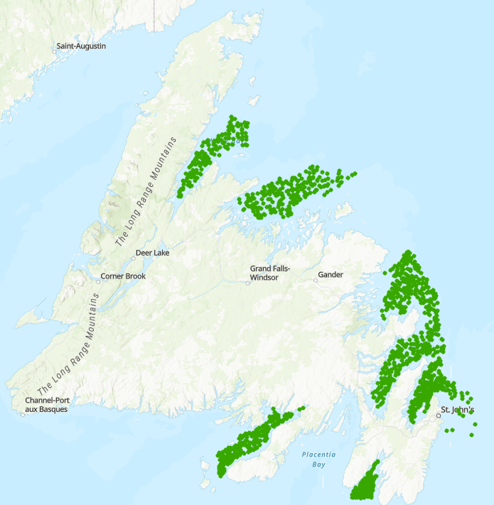
Fleming Survey of Juvenile Atlantic Cod in Coastal Avalon and Northeast Newfoundland (NAFO Div. 3KL)

The Department of Fisheries established a survey of demersal juvenile Atlantic cod (*Gadus morhua*) in the nearshore (<10 m deep) in 1959. This survey aimed to characterize the distribution and abundance of juvenile Atlantic cod and was based upon Norway's Flodevigen sampling program which has been conducted continuously since 1919. A 25 m seine was used to sample juvenile Atlantic cod nursery locations on the Avalon Peninsula and Northeast coast of the island of Newfoundland in September and October. The survey continued until 1964 and became known as the Fleming survey, after original initiator Alistair Fleming. The survey was reinstated by Memorial University of Newfoundland from 1992 to 1997. Multiple tows were conducted at a subset of the original 55 Fleming sites located in St. Mary's Bay, Trepassey Bay, the Southern Shore, Conception Bay, Trinity Bay, Bonavista Bay, Gander Bay, New World Island, Fortune Harbour, Badger Bay, Halls Bay and Green Bay. This data set includes several different subsets, some of which span both Fleming Survey periods (1959-1964 and 1992-1997): I. JuvCodCatch60s90s: Catches of juvenile Atlantic cod (1959-1964, 1992-1997) from the first two consecutive tows at each site. This is a summary based on JuvCodLengths90s and FlemingSurveyData60s; II. JuvCodLength90s: Lengths of all individual juvenile Atlantic cod caught for each site (1992-1997); III. SiteEnvData60s90s: Station data for Fleming data 1992-1997; IV. FlemingSurveyData60s: Fleming survey data from 1959-1964 (note there are three record types pertaining to: station data "type 1"; general species catch data including juvenile Atlantic cod grouped by age class ("1+", "Zeroes", and "Total") "type 2; and juvenile Atlantic cod (species 223) listed in length bins "type 3"; and V. FlemingBycatch60s92to96: Bycatch data from 1959-1964 & 1992-1996 from first two tows at each site. This is a summary based partly on the FlemingSurveyData60s set.
-
This data is from the Newfoundland and Labrador Region Inshore Trap survey, specific to Snow Crab from 2018-25, with only successful sets included in the database. Details of annual survey coverage and an overview of the survey program can be found in Pantin et al. (2025). This trap survey follows a depth-stratified random survey design, designated by type = 1 (Survey). Data were available from DFO inshore trap surveys in Fortune Bay, St. Mary’s Bay, Conception Bay, Trinity Bay, Bonavista Bay, Notre Dame Bay, White Bay, and infrequently along the Northeast Avalon Peninsula. All surveys follow a depth-stratified survey design with set locations randomly distributed within each stratum, and stratum-specific set allocations weighted by area. All surveys utilize large-mesh (5.25”) and small-mesh (42 mm) traps intermittently placed within each ‘fleet’ of gear, with traps spaced approximately 45 m (i.e., 25 fathoms) apart. Each fleet includes six baited traps, with two additional end traps not baited. Squid (Illex spp.) hung on skivers is attached to the inner entry cone of each trap as bait, with approximately 2–3 pounds of squid on each skiver. Although soak times are intended to be standardized to 24–48 hours, weather and other factors can affect the surveys and soak times are ultimately variable. Biological sampling is conducted at-sea from all traps at each station and is described in Pantin et al. (2025). Whole weights of Snow Crab are not always taken for every crab (e.g., in poor weather, missing limbs, carapace covered in biofouling) and those without measurements are denoted by an NA in the dataset. Analyses by the DFO NL Snow Crab group apply a length-weight relationship to determine weights, which is not in this dataset. Traps that caught zero Snow Crab are denoted in the dataset by a ‘number’ of 0. References: Pantin, J., D. Mullowney, K. Baker, K. Lefort, W. Coffey, F. Cyr, H. Munro, and Koen-Alonso, M. 2025. An Assessment of Newfoundland and Labrador Snow Crab (Chionoecetes opilio) in 2023. DFO. Can. Sci. Advis. Sec. Res. Doc. 2025/080. iv + 152 p.
-

Fish Habitat Assessment Output: 9 of 16 Average Water Level (75.0m ASL) - Spawning Habitat - High Vegetation Association Species (All Temperature Windows) Habitat suitability was assessed for the Bay of Quinte Area of Concern, at a 3 m grid resolution, using the Habitat Ecosystem Assessment Tool (HEAT), temperature algorithms, vegetation models, and water level input. Habitat classifications were based on three variables: depth (elevation), vegetation, and substrate; and modified by temperature suitabilities. The final suitability maps were based on documented habitat and temperature associations for the fish in the area. Different life stages (spawning requirements, nursery habitat, adult habitat) were modeled for the years of 1972-2011. Suitability values were scaled from 0 (not suitable) to 1 (highly suitable) and converted to suitability classes of very low, low, medium, and high. The final maps for each guild – life stage combination are maximum suitability values from the 39-year period modelled.
-

Fish Habitat Assessment Output: 1 of 16 High Water Level (75.4m ASL) - Spawning Habitat - High Vegetation Association Species (All Temperature Windows) Habitat suitability was assessed for the Bay of Quinte Area of Concern, at a 3 m grid resolution, using the Habitat Ecosystem Assessment Tool (HEAT), temperature algorithms, vegetation models, and water level input. Habitat classifications were based on three variables: depth (elevation), vegetation, and substrate; and modified by temperature suitabilities. The final suitability maps were based on documented habitat and temperature associations for the fish in the area. Different life stages (spawning requirements, nursery habitat, adult habitat) were modeled for the years of 1972-2011. Suitability values were scaled from 0 (not suitable) to 1 (highly suitable) and converted to suitability classes of very low, low, medium, and high. The final maps for each guild – life stage combination are maximum suitability values from the 39-year period modelled.
-

Fish Habitat Assessment Output: 12 of 16 Average Water Level (75.0m ASL) - Nursery Habitat - Low Vegetation Association Species (All Temperature Windows) Habitat suitability was assessed for the Bay of Quinte Area of Concern, at a 3 m grid resolution, using the Habitat Ecosystem Assessment Tool (HEAT), temperature algorithms, vegetation models, and water level input. Habitat classifications were based on three variables: depth (elevation), vegetation, and substrate; and modified by temperature suitabilities. The final suitability maps were based on documented habitat and temperature associations for the fish in the area. Different life stages (spawning requirements, nursery habitat, adult habitat) were modeled for the years of 1972-2011. Suitability values were scaled from 0 (not suitable) to 1 (highly suitable) and converted to suitability classes of very low, low, medium, and high. The final maps for each guild – life stage combination are maximum suitability values from the 39-year period modelled.
-

Fish Habitat Assessment Output: 10 of 16 Average Water Level (75.0m ASL) - Spawning Habitat - Low Vegetation Association Species (All Temperature Windows) Habitat suitability was assessed for the Bay of Quinte Area of Concern, at a 3 m grid resolution, using the Habitat Ecosystem Assessment Tool (HEAT), temperature algorithms, vegetation models, and water level input. Habitat classifications were based on three variables: depth (elevation), vegetation, and substrate; and modified by temperature suitabilities. The final suitability maps were based on documented habitat and temperature associations for the fish in the area. Different life stages (spawning requirements, nursery habitat, adult habitat) were modeled for the years of 1972-2011. Suitability values were scaled from 0 (not suitable) to 1 (highly suitable) and converted to suitability classes of very low, low, medium, and high. The final maps for each guild – life stage combination are maximum suitability values from the 39-year period modelled.
-
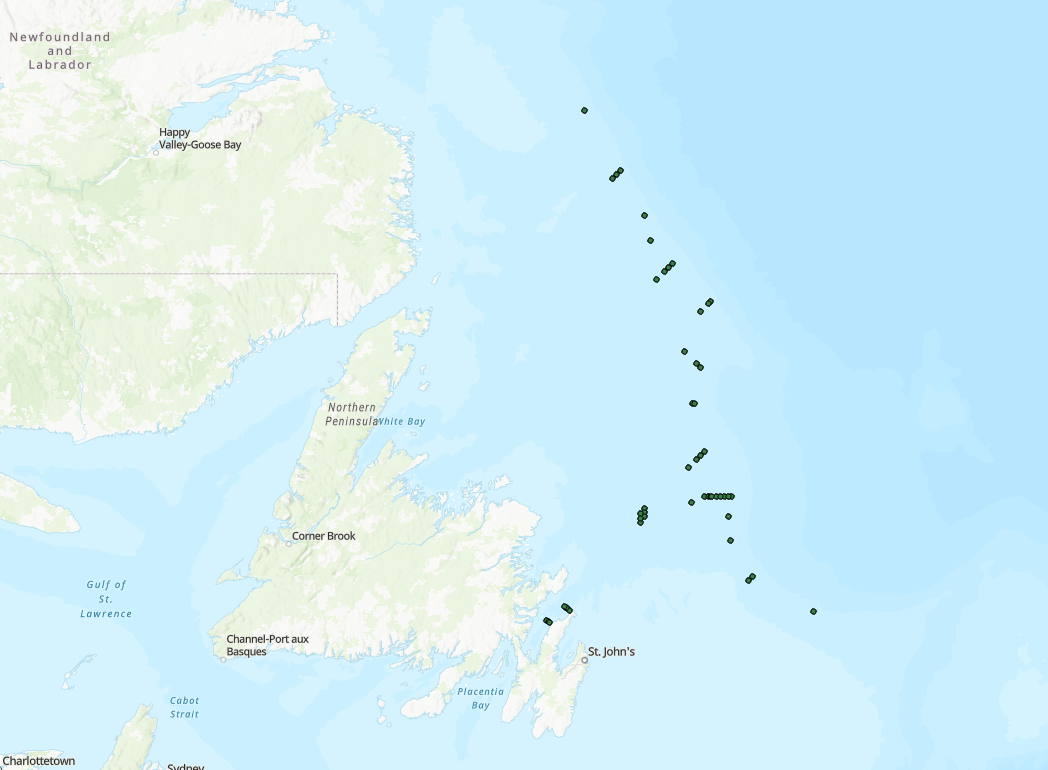
Greenland halibut (Reinhardtius hippoglossoides) occupy deep waters off Newfoundland and Labrador and are a commercially important species. The Groundfish Section, Fisheries and Oceans Canada – Newfoundland and Labrador Region implemented an acoustic tagging program to better understand the movement and habitat use for this species. This program began in 2021, and was further developed as a results of two DFO Competitive Science Research Fund project between 2022-2026. Fish were caught via trawl or longline, VEMCO acoustic transmitters surgically implanted, and released at site of capture. Detections occurred from acoustic receivers deployed by the Groundfish section and/or from receiver arrays associated with the Oceans Tracking Network (e.g. Northern Cod Acoustic Telemetry Array [NCAT]). Raw detection data are downloaded from receivers and sent to the Ocean Tracking Network for formatting and archiving. Data provided here summarize reported detections from 2021-2024 as part of a master’s project at Memorial University of Newfoundland. Release locations, number and location of detections, defined movement class, and detection duration are summarized by individual. Location information includes the position of the receiver the fish was detected at, and the North Atlantic Fisheries Organization (NAFO) Divisions where fish were detected in.
-

Fish Habitat Assessment Output: 11 of 16 Average Water Level (75.0m ASL) - Nursery Habitat - High Vegetation Association Species (All Temperature Windows) Habitat suitability was assessed for the Bay of Quinte Area of Concern, at a 3 m grid resolution, using the Habitat Ecosystem Assessment Tool (HEAT), temperature algorithms, vegetation models, and water level input. Habitat classifications were based on three variables: depth (elevation), vegetation, and substrate; and modified by temperature suitabilities. The final suitability maps were based on documented habitat and temperature associations for the fish in the area. Different life stages (spawning requirements, nursery habitat, adult habitat) were modeled for the years of 1972-2011. Suitability values were scaled from 0 (not suitable) to 1 (highly suitable) and converted to suitability classes of very low, low, medium, and high. The final maps for each guild – life stage combination are maximum suitability values from the 39-year period modelled.
-
Fish Habitat Assessment Output: 8 of 16 High Water Level (75.4m ASL) - Juvenile/Adult Habitat - Low Vegetation Association Species (Coldwater) Habitat suitability was assessed for the Bay of Quinte Area of Concern, at a 3 m grid resolution, using the Habitat Ecosystem Assessment Tool (HEAT), temperature algorithms, vegetation models, and water level input. Habitat classifications were based on three variables: depth (elevation), vegetation, and substrate; and modified by temperature suitabilities. The final suitability maps were based on documented habitat and temperature associations for the fish in the area. Different life stages (spawning requirements, nursery habitat, adult habitat) were modeled for the years of 1972-2011. Suitability values were scaled from 0 (not suitable) to 1 (highly suitable) and converted to suitability classes of very low, low, medium, and high. The final maps for each guild – life stage combination are maximum suitability values from the 39-year period modelled.
-

Fish Habitat Assessment Output: 6 of 16 High Water Level (75.4m ASL) - Juvenile/Adult Habitat - Low Vegetation Association Species (Warmwater Guild) Habitat suitability was assessed for the Bay of Quinte Area of Concern, at a 3 m grid resolution, using the Habitat Ecosystem Assessment Tool (HEAT), temperature algorithms, vegetation models, and water level input. Habitat classifications were based on three variables: depth (elevation), vegetation, and substrate; and modified by temperature suitabilities. The final suitability maps were based on documented habitat and temperature associations for the fish in the area. Different life stages (spawning requirements, nursery habitat, adult habitat) were modeled for the years of 1972-2011. Suitability values were scaled from 0 (not suitable) to 1 (highly suitable) and converted to suitability classes of very low, low, medium, and high. The final maps for each guild – life stage combination are maximum suitability values from the 39-year period modelled.