 Arctic SDI catalogue
Utility and governmental services
Type of resources
Available actions
Topics
Keywords
Contact for the resource
Provided by
Years
Formats
Update frequencies
status
Service types
Scale
-
This service provides INSPIRE Data.
-
OR_hitaveita er byggt upp af punktum (þ.e. innmælingar og búnaður), línum (þ.e.stokkar oglagnir)og flákum (þ.e. mannvirki eins og dælustöðvar og brunnar)
-
OR_fraveita er byggt upp af línum (lögnum), punktum (búnaði) og flákum (settjörnum).
-
Niðurhalsþjónustur fyrir INSPIRE tilskipunina og grunngerð landupplýsinga. Vefþjónn fyrir landfræðileg gögn Umhverfisstofnunar. Vefþjónnin er byggður á opnum staðli OGC og hægt er að nálgast gögnin á vefþjóninum í gegnum ýmsar tegundir þjónusta, s.s. WFS, WMS.
-

Skoðunarþjónustur fyrir INSPIRE tilskipunina
-

EuroBoundaryMap is a seamless geo-database at the scale 1:100 000 covering 55 countries. It contains geometry, names and codes of administrative and statistical units continuously updated by the members of EuroGeographics, the national mapping and cadastral authorities (NMCAs) of Europe. Updated annually. Datasets in EBM: The EBM dataset was derived from the Icelandic National Database IS 50V, which is at the scale 1:50.000. The generalization has been applied in form of smooth polygon and simplify polygon that ensured the required resolution of the data for the EBM 1: 100 000 scale. The topological relations of the line and area features were ensured. Administrative Units includes: AdministrativeBoundary a line layer containing the demarcations outlining administrative units. AdministrativeUnit_1 a polygon layer containing the national administrative hierarchy, Level 1 (republic). AdministrativeUnit_2 a polygon layer containing the national administrative hierarchy, Level 2 (municipalities). Residence of Authority a point layer containing the administrative centres of all administrative levels. BasicGeometry includes: EBM_A a polygon layer containing administrative areas. Here are the basic components on which administrative units of all hierarchical levels, as well as all statistical layers, are composed. EBM_P a point layer meant for labelling purposes. Label points are located within the main area of the administrative units on lowest level. StatisticalUnits includes: LAU a polygon layer = Local Administrative Unit. NUTS_1 a polygon layer = Nomenclature of Territorial Units for Statistics (whole country) NUTS_2 a polygon layer NUTS_3 a polygon layer = Nomenclature of Territorial Units for Statistics (capital area, rural areas) Tables in EBM: CountryCodes = all countries have unique country codes (icc). EBM_CHR = country codes of those countries where the language is used in alphabetical order delimited by #. EBM_coAdministered = Relationship between administrative unit and its co-administering administrative units on the same hierarchical level. A few countries have special areas with shared administrative units. EBM_ISN = designations of administrative hierarchical levels EBM_NAM = names of administrative units EBM_NUTS = Relationship between the SHN codes of administrative units on lowest national administrative level and corresponding statistical codes.
-
Fráveituvatn er í eðli sínu notað vatn. Vatn sem við höfum nýtt til að baða okkur, elda mat, sturta niður í klósettin, þvo bíla, föt og ýmislegt annað. Notkunin veldur því að allskonar efni s.s. úrgangur frá fólki, matarleifar, olíur, sápur, hreinsiefni, málmar og jafnvel hættuleg efni blandast í annars hreint vatn. - Fráveituvatn getur verið mengunarvaldur en góð hreinsun getur dregið verulega úr neikvæðum áhrifum þess: - Úrgangur frá fólki er saurmengaður lífrænn úrgangur sem inniheldur bæði áburðarefni og mikið magn örvera og sýkla. - Í fráveituna berst ýmis úrgangur t.d. af yfirborði gatna og rusl (blautklútar, tannþráður o.fl.) sem er hent í í salerni. - Ýmis hættuleg efni s.s. úr hreinsiefnum, eldtefjandi efni og skordýraeitur geta fundist í fráveituvatni. - Mikið magn af næringarefnum (fosfór og köfnunarefni) í skólpi getur valdið ofauðgun eða aukinni framleiðslu þörunga (þörungablóma) sem getur leitt til skorts á súrefni í vatninu. Slíkt hefur neikvæð áhrif á staðbundið vatnalíf og getur valdið dauða ýmissa lífvera. - Fráveituvatn mengað af lyfjaleifum getur haft neikvæð áhrif á dýr, eins og fjölgun og hegðun þeirra. Losun sýklalyfja í skólpi eykur þróun lyfjaónæmis hjá bakteríum í umhverfinu. Best er að draga eins og hægt er úr allri efnanotkun og sturta ekki efnum í klósett og niðurföll heldur fara með þau til móttökuaðila slíks úrgangs.
-
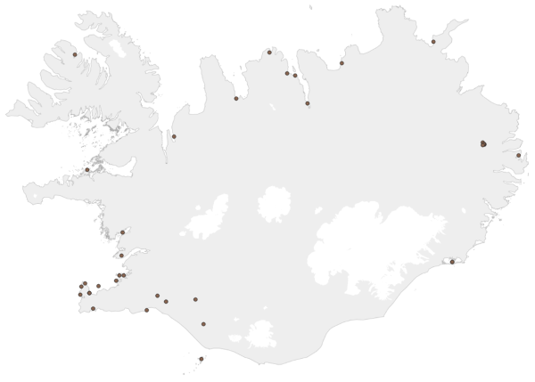
Gögnin veita upplýsingar um hvar hægt er að losa úr ferðasalernum. Í reglugerð um hollustuhætti segir að á tjald- og hjólhýsasvæðum eða í námunda við það skuli vera aðstaða til að tæma og hreinsa ferðasalerni. Rekstraraðili svæðisins skuli veita upplýsingar um og vísa á aðstöðuna, en einnig er hægt að leita upplýsinga um staðsetningu slíkrar aðstöðu annars staðar, t.d. hjá upplýsingamiðstöðvum og á bensínstöðvum. Árið 2012 tók Umhverfisstofnun saman lista yfir þá staði á landinu þar sem finna má aðstöðu til losunar ferðasalerna. Listinn er byggður á upplýsingum frá heilbrigðiseftirliti sveitarfélaganna.
-

The BarentsWatch WMS service provides the service layers used for the services at barentswatch.no and a few additional layers in order to make the information more accessible for other uses. The service layers can be adapted further if needs are clarified. Some service layers that are not appropriate for external use are not referred to. All the service layers are based on data from other agencies. Therefore, BarentsWatch/the Norwegian Coastal Administration are not the owners of all the data. If BarentsWatch does not add new information and the service layer is already presented by the data owner, it is not added to Geonorge even if it occurs in the service. See also BarentsWatch API for other access to the same data.
-

EuroRegionalMap is a Pan-European multi-functional topographic vector dataset at scale 1: 250000, that is seamless and harmonized across boundaries. It is produced in cooperation with the National Mapping Agencies of the participating countries using official national databases. The dataset covers 36 countries and is designed for business use. It enables you to process comprehensive spatial analysis. Transport and water networks have full connectivity and administrative boundaries are topologically consistent. The National Database (IS 50V at 1:50 000 was used to update the datasets. There are some natural deviations from ERM topology rules and feature selection criteria for Icelandic ERM data.