 Arctic SDI catalogue
2014
Type of resources
Available actions
Topics
Keywords
Contact for the resource
Provided by
Years
Formats
Update frequencies
status
Service types
Scale
Resolution
-

Corine Land Cover (CLC) 2012 and CLC change 2006-2012 are two of the datasets produced within the frame of the Initial Operations of the Copernicus programme (the European Earth monitoring programme previously known as GMES) on land monitoring.Corine Land Cover (CLC) provides consistent information on land cover and land cover changes across Europe. This inventory was initiated in 1985 (reference year 1990) and established a time series of land cover information with updates in 2000, 2006 and 2012 being the last one. CLC products are based on photointerpretation of satellite images by national teams of participating countries - the EEA member and cooperating countries – following a standard methodology and nomenclature with the following base parameters: 44 classes in the hierarchical three level Corine nomenclature; minimum mapping unit (MMU) for status layers is 25 hectares; minimum width of linear elements is 100 metres; minimum mapping unit (MMU) for Land Cover Changes (LCC) for the change layers is 5 hectares. The resulting national land cover inventories are further integrated into a seamless land cover map of Europe. Land cover and land use (LCLU) information is important not only for land change research, but also more broadly for the monitoring of environmental change, policy support, the creation of environmental indicators and reporting. CLC datasets provide important datasets supporting the implementation of key priority areas of the Environment Action Programmes of the European Union as protecting ecosystems, halting the loss of biological diversity, tracking the impacts of climate change, assessing developments in agriculture and implementing the EU Water Framework Directive, among others.More about the Corine Land Cover (CLC) and Copernicus land monitoring data in general can be found at http://land.copernicus.eu/.
-

Nytjaland er verkefni sem miðaði að því að kortleggja yfirborð landsins á grunni þess hversu gróskumikið það væri. Flokkunin var unnin með fjarkönnunaraðferðum með Landsat 7 og SPOT 5 gervitunglamyndum. Yfirborðsflokkarnir 12 eru: Graslendi, ríkt mólendi, ræktað land, Rýrt mólendi, skógur og kjarrlendi, moslendi, hálfdeigja, votlendi, hálfgróið land, líttgróið land, straum- og stöðuvötn, jöklar og fannir og óflokkað, eyjar/sker Verkefnið var unnið frá árunum 1999-2007. Var þá búið að gera yfirborðsflokkun á um 70% landsins í 12 flokka og 30% af yfirborðinu í 6 flokka. Á kortinu Nytjaland_1 hafa gögnin úr 6 flokka flokkuninni verið aðlöguð að 12 flokka flokkunninni. Flokkurinn sem dekkaði gróið land í 6 flokka flokkunninni var allur sameinaður floknum rýrt mólendi í 12 flokka flokkunninni. Upplýsingum frá Skógrækt ríkisins (2013) um skóga var bætt inn í flokkuðu gögnin. Flokkurinn ræktað land var uppfærður samkvæmt korti af ræktuðu landi sem hnitað var inn af gervitunglamyndum. Ár og vötn, jöklar, fannir og strandlína var aðlagað að vatnafarsgrunni LMÍ (2013). Rastagrunnurinn er í mælikvarðanum 1:30.000.
-
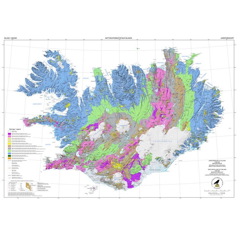
Gagnasafn (GDB) NI_J600v_berg_2.utg: Jarðfræðikorti af Íslandi – Berggrunnur – 1:600.000 [Geological Map of Iceland – Bedrock geology – 1:600.000]. Berggrunnskort af Íslandi sýnir stærstu drættina í jarðfræði landsins. Jarðlög eru flokkuð eftir aldri, gerð og samsetningu. Kortið sýnir vel gosbelti landsins og dreifingu gossstöðva frá nútíma. Nútímahraunum er skipt í forsöguleg og söguleg hraun (yngri en 871 e. Kr. ). [The Geological Map of Iceland shows the main features of the bedrock geology. Formation are classified by age, type, and composition. The map clearly shows the island's volcanic zones and the distribution of the recent eruption sites. Lava fields of the Holocene are shown as pre-historic or historic (younger than AD 871].]
-

IS: Gögnin veita upplýsingar um stærð, staðsetningu og tegundir náttúruverndarsvæða á Íslandí samræmi við lög nr.60/2013 um náttúruvernd. Sum friðlýstu svæðanna ná út haf. EN: The data provides information about location, size and types of nature conservation areas in Iceland according to the nature conservation act nr. 60/2013. Some of the protected areas extend into the ocean.
-
This is the reference implementation of WFS 1.0.0 and WFS 1.1.0, supports all WFS operations including Transaction.
-
WMS
-
WMS
-
-
WMS
-
WMS