 Arctic SDI catalogue
Waste water
Type of resources
Available actions
Topics
Keywords
Contact for the resource
Provided by
Formats
Representation types
Update frequencies
status
-

This set presents the geolocation as well as general information [of retention basins] (https://montreal.ca/articles/ouvrages-de-retention-limiter-les-rejets-deaux-usees-14459) on the Montreal territory whose construction has been completed.**This third party metadata element was translated using an automated translation tool (Amazon Translate).**
-
The sewer system (secondary and main networks) on the Island of Montreal includes 170 overflow structures. An overflow structure consists of an underground control chamber that directs wastewater into the collection and interception network under normal operating conditions to the treatment plant. During rain, melt or during an operation associated with maintenance or impairment, the inputs exceed the regulatory capacity and this excess is overflowed by the structure in question in the watercourses. It is under these conditions that part of the water combining rainwater and wastewater flows to the receiving watercourse for a short period of time (via the outfall). Obviously, the receiving watercourse to the south is the St. Lawrence River and that to the north, the Rivière des Prairies.**This third party metadata element was translated using an automated translation tool (Amazon Translate).**
-
An element of the drainage system intended for the collection and delivery of runoff water to the sewer line or ditch. Structure, equipped with a spillway, used to capture runoff and deliver it, as appropriate, to the storm sewer or combined sewer line. The information associated with the geographic data corresponds to the type of sump, date of installation, status, owner, and jurisdiction. __CAUTION__: This data is published annually, so it does not include updates made during the year. For this reason, they should under no circumstances be used for engineering purposes without validation by the City. **This third party metadata element was translated using an automated translation tool (Amazon Translate).**
-
This set of punctual data shows the manholes located on the Island of Montreal. These manholes are compartments through which sewers can be accessed in order to clean, inspect and maintain them. The manholes are placed at regular intervals on the right-hand section of the main pipe. In straight sections, the maximum distance between two manholes is 120 meters. The manholes are generally placed at the beginning of a network, i.e. at the head of the furthest section and at the points where the pipe changes direction, altitude, slope and/or diameter. The information associated with the geographic data corresponds to the type and material of the manhole, date of installation, status, owner and jurisdiction. __CAUTION__: This data is published annually, so it does not include updates made during the year. For this reason, they should under no circumstances be used for engineering purposes without validation by the City. **This third party metadata element was translated using an automated translation tool (Amazon Translate).**
-

The Wastewater Systems Effluent Regulations (WSER), developed under the Fisheries Act, came into force in 2012 to manage wastewater releases by systems that collect an average daily influent volume of 100 cubic metres or more. The WSER also does not apply to any wastewater system located in the Northwest Territories, Nunavut and north of the 54th parallel in the provinces of Quebec and Newfoundland and Labrador. The WSER set national baseline effluent quality standards that are achievable through secondary wastewater treatment. Under the WSER, owners or operators of wastewater systems discharging annual average daily effluent volumes greater than 2,500 m3 are required to determine and report on the acute lethality of the effluent. The map below presents the percentage of acute lethality test failures for the wastewater systems in Canada that conducted at least one acute lethality test according to the standards of the Wastewater Systems Effluent Regulations. The map is available in both ESRI REST (to use with ARC GIS) and WMS (open source) formats. For more information about the individual reporting wastewater systems, datasets are available in either Excel or CSV formats. Data from Quebec and Yukon As of 2018, no acute lethality results from Quebec municipalities are available since an equivalency agreement is now in effect. As of 2015, no acute lethality test results for wastewater systems in the Yukon are available as an equivalency agreement in is effect. More information on the wastewater sector including the regulations, agreements, contacts and resource documents is available at: https://www.canada.ca/wastewater
-

The Wastewater Systems Effluent Regulations (WSER), developed under the Fisheries Act, came into force in 2012 to manage wastewater releases by systems that collect an average daily influent volume of 100 cubic metres or more. The WSER also does not apply to any wastewater system located in the Northwest Territories, Nunavut and north of the 54th parallel in the provinces of Quebec and Newfoundland and Labrador. The WSER set national baseline effluent quality standards that are achievable through secondary wastewater treatment. The WSER require owners or operators of wastewater systems with combined sewers to submit an annual report on the total volume and the number of days wastewater is discharged per month via combined sewer overflow (CSO) points as a result of precipitation. The map below shows the volume of effluent (in cubic metres) discharged in a year from all CSO points situated within the collection area of a wastewater system. For the most part, the volumes provided to ECCC are estimates. Please note, a value of “999999999” in the dataset indicates that the volume data is unavailable and it does not mean that a volume of 999,999,999 m3 was released within the collection area of a wastewater system. The map is available in both ESRI REST (to use with ARC GIS) and WMS (open source) formats. For more information about the individual reporting wastewater systems, datasets are available in either CSV or XLS formats. Data from Quebec As of 2018, no combined sewer overflow volumes from Quebec municipalities are available since an equivalency agreement is now in effect. More information on the wastewater sector including the regulations, agreements, contacts and resource documents is available at: https://www.canada.ca/wastewater
-

The Wastewater Systems Effluent Regulations (WSER), developed under the Fisheries Act, came into force in 2012 to manage wastewater releases by systems that collect an average daily influent volume of 100 cubic metres or more. The WSER also does not apply to any wastewater system located in the Northwest Territories, Nunavut and north of the 54th parallel in the provinces of Quebec and Newfoundland and Labrador. The WSER set national baseline effluent quality standards that are achievable through secondary wastewater treatment. The province of Quebec provided some combined sewer overflow data for 2020, which includes information on whether a discharge occurred at a combined sewer overflow point during the year. The map below shows the number of CSO points with at least one overflow event within each wastewater system. The map is available in both ESRI REST (to use with ARC GIS) and WMS (open source) formats. For more information about the individual reporting wastewater systems, datasets are available in either CSV or XLS formats. More information on the wastewater sector including the regulations, agreements, contacts and resource documents is available at: https://www.canada.ca/wastewater
-

The Wastewater Systems Effluent Regulations (WSER), developed under the Fisheries Act, came into force in 2012 to manage wastewater releases by systems that collect an average daily influent volume of 100 cubic metres or more. The WSER also does not apply to any wastewater system located in the Northwest Territories, Nunavut and north of the 54th parallel in the provinces of Quebec and Newfoundland and Labrador. The WSER set national baseline effluent quality standards that are achievable through secondary wastewater treatment. The map below presents data regarding compliance with the WSER effluent quality standards according to their averaging period. Wastewater systems must report on either a monthly, quarterly or annual basis. The dataset also includes the carbonaceous biochemical oxygen demand (CBOD) and suspended solids (SS) results for each wastewater system. Annual reporting: This map layer shows whether or not the wastewater systems met the WSER effluent quality limit according to an annual averaging period for carbonaceous biochemical oxygen demand CBOD or suspended solids SS. Quarterly reporting: This map layer shows whether or not the wastewater systems met the WSER effluent quality standards according to a quarterly averaging period. Note that a system that meets its CBOD limit or its SS limit for more than 75% of the time is considered to be in compliance with the effluent quality standards of the WSER. Monthly reporting: This map layer shows whether or not the wastewater systems met the WSER effluent quality standards according to a monthly averaging period. Note that a system that meets its CBOD limit or its SS limit for more than 75% of the time is considered to be in compliance with the effluent quality standards of the WSER. The map is available in both ESRI REST (to use with ARC GIS) and WMS (open source) formats. For more information about the individual reporting wastewater systems, datasets are available in either CSV or XLS formats. Data from Quebec and Yukon The data for Quebec municipalities (after 2017) is provided to the department separately through the equivalency agreement that was finalized in October 2018. Beginning in 2015, the data reported for the Yukon is provided to the department separately through an equivalency agreement finalized in 2014. More information on the wastewater sector including the regulations, agreements, contacts and resource documents is available at: https://www.canada.ca/wastewater
-
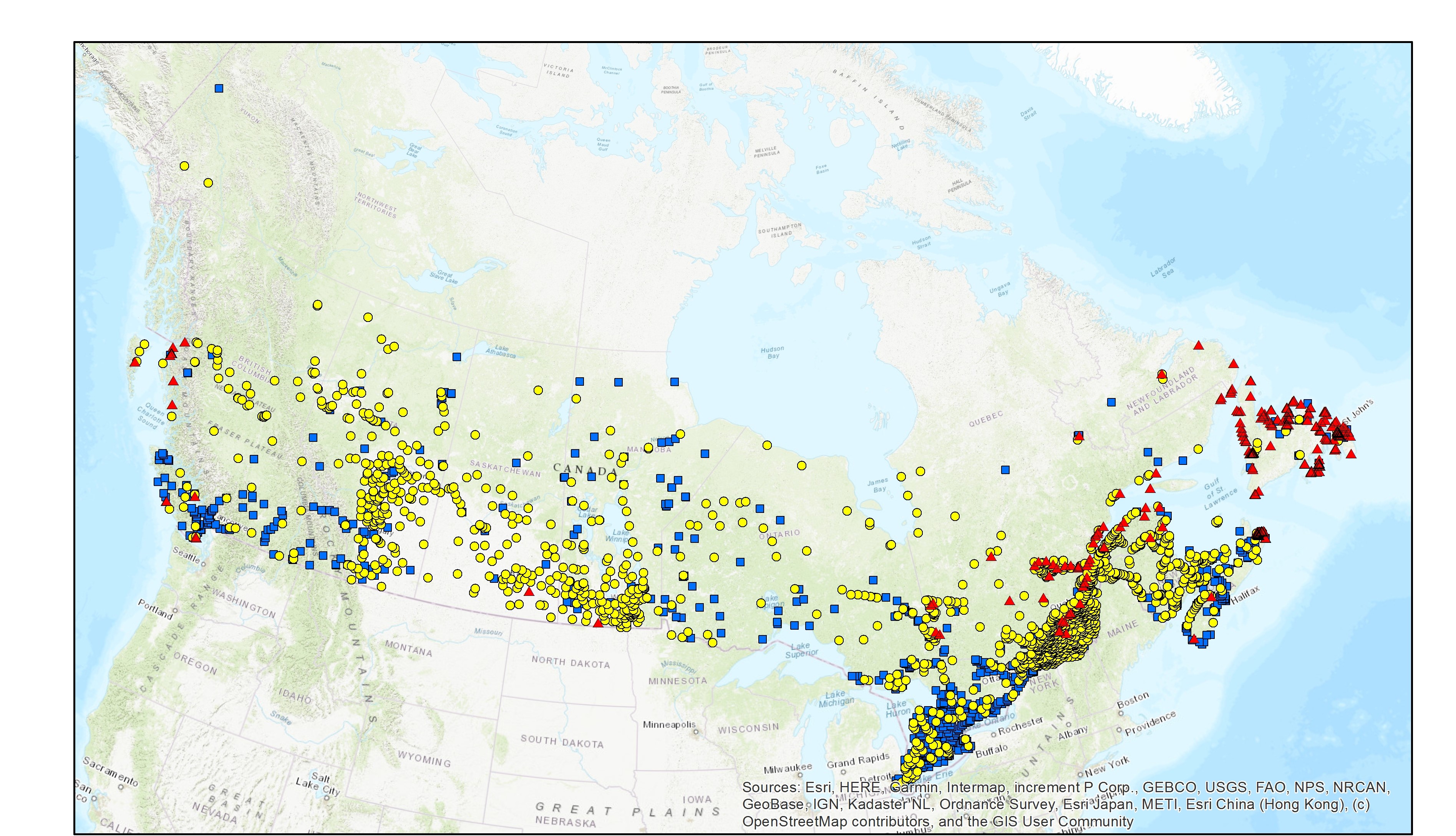
The Wastewater Systems Effluent Regulations (WSER), developed under the Fisheries Act, came into force in 2012 to manage wastewater releases by systems that collect an average daily influent volume of 100 cubic metres or more. The WSER also does not apply to any wastewater system located in the Northwest Territories, Nunavut and north of the 54th parallel in the provinces of Quebec and Newfoundland and Labrador. The WSER set national baseline effluent quality standards that are achievable through secondary wastewater treatment. The map below presents the wastewater system locations in Canada and the type of treatment they utilize (mechanical, lagoon or no treatment). The data is based on the information submitted to Environment and Climate Change Canada as of November 2022. Note that this layer does not represent the level of wastewater treatment or whether the system complies with the WSER. The map is available in both ESRI REST (to use with ARC GIS) and WMS (open source) formats. For more information about the individual reporting wastewater systems, datasets are available in either Excel or CSV formats at the resource listed below: “Wastewater Systems Effluent Regulations Reported Data”. Data from Quebec and Yukon The data for Quebec municipalities (after 2017) is provided to the department separately through the equivalency agreement that was finalized in October 2018. Beginning in 2015, the data reported for the Yukon is provided to the department separately through an equivalency agreement finalized in 2014. More information on the wastewater sector including the regulations, agreements, contacts and resource documents is available at: https://www.canada.ca/wastewater
-

The Indigenous Community Infrastructure dataset depicts infrastructure projects across Canada that are supported by Indigenous Services Canada (ISC) targeted infrastructure funding. It contains data related to project category, description, status, departmental investment and community. The dataset allows the Department to pinpoint and share information about individual infrastructure projects in Indigenous communities, in a proactive and transparent manner, to: • Showcase where and how investments are carried out • Demonstrate the Government’s commitment to address socio-economic gaps between Indigenous and non-Indigenous communities in Canada and improve access to high-quality services Projects featured in this Indigenous Community Infrastructure dataset are updated on a quarterly basis. Because some projects will benefit more than one community, the number of projects does not match the number of markers on the map or of entries in the dataset. For more information, visit https://www.sac-isc.gc.ca/eng/1526995988708/1526996020578.