 Arctic SDI catalogue
forests
Type of resources
Available actions
Topics
Keywords
Contact for the resource
Provided by
Formats
Representation types
Update frequencies
status
Scale
-
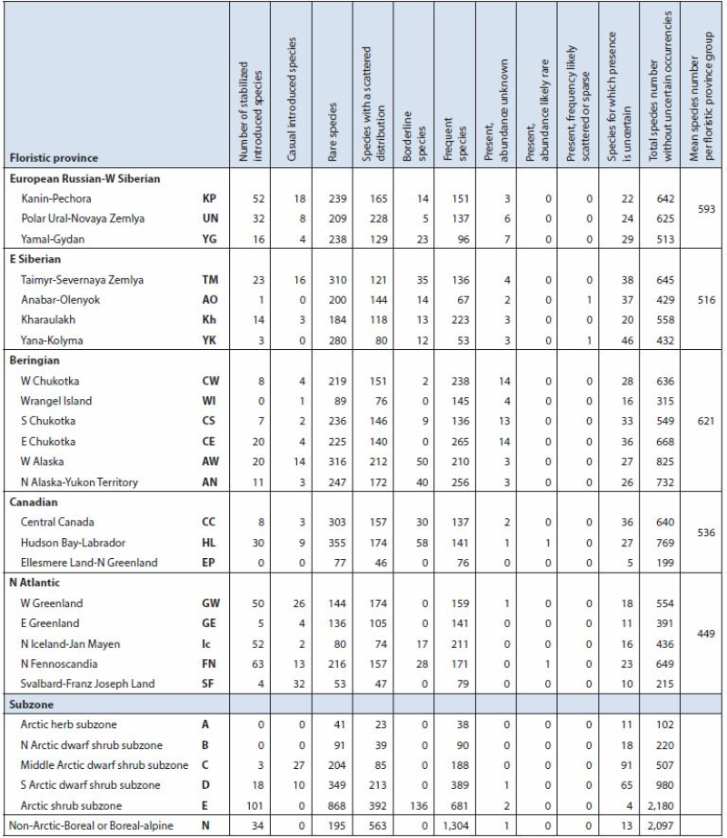
Summary of Arctic vascular plant species and distribution by Arctic flora province and subzone based on Elven (2007). Arctic floristic provinces, subzones (A-E), neighbouring boreal or boreal-alpine zone (N) and distribution derived from Elven (2007). Arctic Biodiversity Assessment - Table 9.1 Conservation of Arctic Flora and Fauna, CAFF 2013 - Akureyri . Arctic Biodiversity Assessment. Status and Trends in Arctic biodiversity. - Plants(Chapter 9) page 321
-

The spatial representation for a Natural Resource (NR) District, that is an administrative area established by the Ministry, within NR Regions.
-
The spatial representation for a Natural Resource (NR) Region, that is an administrative area established by the Ministry, within NR Areas. These boundaries are designated by the Lieutenant Governor in council and published as regulations which establishes the Ministry's management areas. This dataset supersedes WHSE_ADMIN_BOUNDARIES.FADM_REGION
-
The spatial representation for a Natural Resource Area. An NR AREA is an amalgamation of all NR Regions within the supplied boundaries and acts as an administrative area to these regions as established by the Ministry. This dataset supersedes WHSE_ADMIN_BOUNDARIES.NRO_ADM_AREAS_SP
-

Spatial location of all harvesting identified in the first 10 years of 2012 Forest Management Plans for Crown timber licenses. Blocks are identified by broad treatment category and by the period (2012-2016 and 2017-2022) they are available for harvest.
-

A national map of Canadian Fire Behaviour Prediction (FBP) Fuel Types (FT) developed from public data sources. The resolution of the raster grid is 30m, classified from the Spatialized Canadian National Forest Inventory (SCANFI) dataset, ecozones of Canada, and the National Burned Area Composite (NBAC). The purpose of the dataset is to characterize Canadian forests into fuel types for use in Fire Behaviour Prediction calculations as well as for situational awareness of national fire potential.
-

A National Forest Fire Behaviour Prediction (FBP) Fuel Type (FT) layer, representing fuel types as described in the Canadian Forest Fire Danger Rating System (CFFDRS) Canada-wide. This data is developed through the Spatialized Canadian National Forest Inventory (SCANFI) dataset, specifically the updated SCANFI version 2.0. The Fuel Type layer is produced at variable resolution to best meet the needs of users: 30m (default) and 100m (ideal for fire growth modelling). The purpose of this dataset is to characterize Canadian forests into Fuel Types for use in various applications, including wildland fire management, research, fuel management, and more. This layer is primarily developed to support national scale applications and uses but can be utilized for localized landbases and adapted as required. This data represents the most up-to-date national product and is updated annually prior to the start of the fire season to incorporate burned area and additional data from the previous year. This data will be updated annually and published online by April 30th of each year. Note: In this product Slash fuel types (S-1, S-2, and S-3) are not represented. Conifer Plantation (C-6) is not represented. Raster Grid Value 13 represents vegetated fuels without an effective match to an existing FBP Fuel Type under this ruleset. Grid Value 11 (corresponding to D-1 Leafless Aspen) is assumed to represent true Deciduous fuels as described in the FBP system.
-

Canadian forest management has multiple goals and varies in intensity. Governments, forest companies, Indigenous peoples, communities, and many other stakeholders are all involved in the forest management planning process. Management goals and the plans developed by professional foresters to achieve these goals differ from place to place. Canadian forests are often grouped into two categories: managed forest and unmanaged forest. This type of classification is sometimes useful, but the reality is much more complex and interesting. This interactive story map provides information on designations, ownership, forest tenures, and land protection statuses, and provides a comprehensive picture of the geography of Canada's managed forests. It has been updated from an earlier version to show land designations in 2020. **This third party metadata element was translated using an automated translation tool (Amazon Translate).**
-

The digital atlas contains distribution information of dominant forest plants, species assemblages (vegetation types), and some habitat and structural characteristics for the eco-district 6e10 and Greater Park Ecosystem (GPE) — St. Lawrence Islands National Park. We used statistical modeling and prediction to make the distributional information for the entire study area. We extrapolated information from geo-referenced vegetation data collected during summers from 2005 to 2007 with other spatial layers, such as digital elevation and remote sensing derivatives. The maps are in raster (grid) format at a 10m resolution. You can navigate them by following the documents and readme files in the individual folders or in the main document folder called ‘6e10_documents’. In southern Ontario, there is a lack of current ‘wall-to wall’, fine-scale, vegetation class and species vegetation mapping to support diverse applications and initiatives related to natural resource management, conservation and landscape and land-use planning. These maps could serve as baseline information for: * natural heritage design and planning * Species at Risk (SAR) recovery planning * state of biodiversity reporting * forest management and planning * invasive species management * ecological goods and services estimates * wildlife habitat modeling and mapping * additional applications and research techniques * requiring mapped vegetation information __How to reference this dataset__ This product should be referenced as: Puric-Mladenovic, Danijela, Julia Buck; David Bradley, Robert Arends, Silvia Strobl, and Nayna Khalatkar (2008). _Digital atlas of predicted species distributions, vegetation assemblages and habitat characteristics for the eco-district 6e10 and GPE — St. Lawrence Islands National Park’_, version 1.0.. Information Management and Spatial Analysis Unit, Southern Science and Information Section, OMNR, Peterborough, Ontario. __Additional time period information__ Field sampling was collected during the summer months from 2005 to 2007. The following activities took place during 2008: * spectral and environmental data assembly * predictive modelling and mapping Alternate title: Plant atlas for St. Lawrence Islands National Park
-
Spatial location of all harvesting identified in the first 10 years of 2012 Forest Management Plans for Crown timber licenses. Blocks are identified by broad treatment category and by the period (2012-2016 and 2017-2022) they are available for harvest.