 Arctic SDI catalogue
Aerial photography
Type of resources
Available actions
Topics
Keywords
Contact for the resource
Provided by
Years
Formats
Representation types
Update frequencies
status
Service types
-

284 reports including 7324 photographs of various sectors of Montreal between 1960 and 1992, taken at low altitude. The photos were mostly taken in the 1960s and 1970s. ATTENTION: For any use of these photographic archives, it is required that the credit mention be: “Archives de la Ville de Montréal”. See also vertical aerial views of Montreal Island: [1925-1935] (https://donnees.montreal.ca/ville-de-montreal/vues-aeriennes-de-l-ile-de-montreal-1925-1935), [1947-1949] (https://donnees.montreal.ca/ville-de-montreal/vues-aeriennes-archives), [1958-1975] (https://donnees.montreal.ca/ville-de-montreal/vues-aeriennes-de-montreal-1958-1975).**This third party metadata element was translated using an automated translation tool (Amazon Translate).**
-
3920 aerial photographs showing the state of the territory of the Island of Montreal between 1947 and 1949, before major urban planning projects and shoreline development. ATTENTION: For any use of these photographic archives, it is required that the credit mention be: “Archives de la Ville de Montréal”. See also the [General Land Use Plans of the City of Montreal in 1949] (https://donnees.montreal.ca/ville-de-montreal/plans-generaux-d-occupation-du-sol-de-la-ville-de-montreal-1949) and the [Detailed Land Use Plans of the City of Montreal in 1949] (https://donnees.montreal.ca/ville-de-montreal/plans-detailles-d-occupation-du-sol-de-la-ville-de-montreal-1949). See also aerial views of Montreal Island: [1925-1935] (https://donnees.montreal.ca/ville-de-montreal/vues-aeriennes-de-l-ile-de-montreal-1925-1935), [1958-1975] (https://donnees.montreal.ca/ville-de-montreal/vues-aeriennes-de-montreal-1958-1975), [1960-1992] (https://donnees.montreal.ca/ville-de-montreal/vues-aeriennes-obliques-de-l-ile-de-montreal-1960-1992)**This third party metadata element was translated using an automated translation tool (Amazon Translate).**
-

During flooding episodes, areas may be flooded even though the cartography established does not indicate that they are located in flood zones. This situation can occur when the water levels reached exceed those represented on the map or when floods affect areas that have not yet been studied. These cartographic data correspond to the delimitation of these territories and are used to produce event maps of these floods. __To date, the following sectors have been maped:__ * Lac-Saint-Jean (2022) * Lac-Saint-Jean (2022) * Saint-Maurice River (2022) Photogrammetric capture, allowing the delimitation of these territories, was carried out following the farthest limit reached by the waters from aerial photographs taken during the floods. It should be noted that this work is part of measure 4 of __ [Plan for the protection of the territory against floods (PPTFI)] (https://www.quebec.ca/gouvernement/politiques-orientations/plan-de-protection-du-territoire-face-aux-inondations)__.**This third party metadata element was translated using an automated translation tool (Amazon Translate).**
-
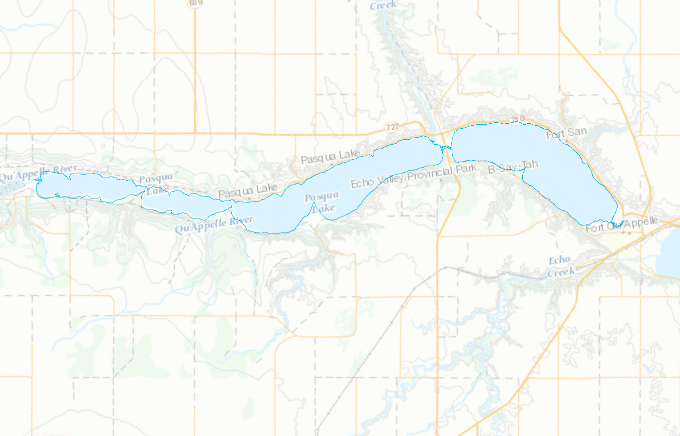
Shorelines for the Pasqua, Crooked, Echo, and Round Lakes within the Qu'Appelle Valley River system in Saskatchewan
-

Note: To visualize the data in the viewer, zoom into the area of interest. The National Air Photo Library (NAPL) of Natural Resources Canada archives over 6 million aerial photographs covering all of Canada, some of which date back to the 1920s. This collection includes Time Series of aerial orthophoto mosaics over a selection of major cities or targeted areas that allow the observation of various changes that occur over time in those selected regions. These mosaics are disseminated through the Data Cube Platform implemented by NRCan using geospatial big data management technologies. These technologies enable the rapid and efficient visualization of high-resolution geospatial data and allow for the rapid generation of dynamically derived products. The data is available as Cloud Optimized GeoTIFF (COG) for direct access and as Web Map Services (WMS) or Web Coverage Services (WCS) with a temporal dimension for consumption in Web or GIS applications. The NAPL mosaics are made from the best spatial resolution available for each time period, which means that the orthophotos composing a NAPL Time Series are not necessarily coregistrated. For this dataset, the spatial resolutions are: 100 cm for the year 1947 and 50 cm for the year 1967. The NAPL indexes and stores federal aerial photography for Canada, and maintains a comprehensive historical archive and public reference centre. The Earth Observation Data Management System (EODMS) online application allows clients to search and retrieve metadata for over 3 million out of 6 million air photos. The EODMS online application enables public and government users to search and order raw Government of Canada Earth Observation images and archived products managed by NRCan such as aerial photos and satellite imagery. To access air photos, you can visit the EODMS web site: https://eodms-sgdot.nrcan-rncan.gc.ca/index-en.html
-

Note: To visualize the data in the viewer, zoom into the area of interest. The National Air Photo Library (NAPL) of Natural Resources Canada archives over 6 million aerial photographs covering all of Canada, some of which date back to the 1920s. This collection includes Time Series of aerial orthophoto mosaics over a selection of major cities or targeted areas that allow the observation of various changes that occur over time in those selected regions. These mosaics are disseminated through the Data Cube Platform implemented by NRCan using geospatial big data management technologies. These technologies enable the rapid and efficient visualization of high-resolution geospatial data and allow for the rapid generation of dynamically derived products. The data is available as Cloud Optimized GeoTIFF (COG) for direct access and as Web Map Services (WMS) or Web Coverage Services (WCS) with a temporal dimension for consumption in Web or GIS applications. The NAPL mosaics are made from the best spatial resolution available for each time period, which means that the orthophotos composing a NAPL Time Series are not necessarily coregistrated. For this dataset, the spatial resolutions are: 75 cm for the year 1960 and 50 cm for the year 1974. The NAPL indexes and stores federal aerial photography for Canada, and maintains a comprehensive historical archive and public reference centre. The Earth Observation Data Management System (EODMS) online application allows clients to search and retrieve metadata for over 3 million out of 6 million air photos. The EODMS online application enables public and government users to search and order raw Government of Canada Earth Observation images and archived product managed by NRCan such as aerial photos and satellite imagery. To access air photos, you can visit the EODMS web site: https://eodms-sgdot.nrcan-rncan.gc.ca/index-en.html
-

Note: To visualize the data in the viewer, zoom into the area of interest. The National Air Photo Library (NAPL) of Natural Resources Canada archives over 6 million aerial photographs covering all of Canada, some of which date back to the 1920s. This collection includes Time Series of aerial orthophoto mosaics over a selection of major cities or targeted areas that allow the observation of various changes that occur over time in those selected regions. These mosaics are disseminated through the Data Cube Platform implemented by NRCan using geospatial big data management technologies. These technologies enable the rapid and efficient visualization of high-resolution geospatial data and allow for the rapid generation of dynamically derived products. The data is available as Cloud Optimized GeoTIFF (COG) for direct access and as Web Map Services (WMS) or Web Coverage Services (WCS) with a temporal dimension for consumption in Web or GIS applications. The NAPL mosaics are made from the best spatial resolution available for each time period, which means that the orthophotos composing a NAPL Time Series are not necessarily coregistrated. For this dataset, the spatial resolutions are: 100 cm for the year 1932 and 50 cm for the year 1950. The NAPL indexes and stores federal aerial photography for Canada, and maintains a comprehensive historical archive and public reference centre. The Earth Observation Data Management System (EODMS) online application allows clients to search and retrieve metadata for over 3 million out of 6 million air photos. The EODMS online application enables public and government users to search and order raw Government of Canada Earth Observation images and archived products managed by NRCan such as aerial photos and satellite imagery. To access air photos, you can visit the EODMS web site: https://eodms-sgdot.nrcan-rncan.gc.ca/index-en.html
-

Note: To visualize the data in the viewer, zoom into the area of interest. The National Air Photo Library (NAPL) of Natural Resources Canada archives over 6 million aerial photographs covering all of Canada, some of which date back to the 1920s. This collection includes Time Series of aerial orthophoto mosaics over a selection of major cities or targeted areas that allow the observation of various changes that occur over time in those selected regions. These mosaics are disseminated through the Data Cube Platform implemented by NRCan using geospatial big data management technologies. These technologies enable the rapid and efficient visualization of high-resolution geospatial data and allow for the rapid generation of dynamically derived products. The data is available as Cloud Optimized GeoTIFF (COG) files for direct access and as Web Map Services (WMS) or Web Coverage Services (WCS) with a temporal dimension for consumption in Web or GIS applications. The NAPL mosaics are made from the best spatial resolution available for each time period, which means that the orthophotos composing a NAPL Time Series are not necessarily coregistered. For this dataset, the spatial resolutions are: 100 cm for the year 1947 and 50 cm for the year 1977. The NAPL indexes and stores federal aerial photography for Canada, and maintains a comprehensive historical archive and public reference centre. The Earth Observation Data Management System (EODMS) online application allows clients to search and retrieve metadata for over 3 million out of 6 million air photos. The EODMS online application enables public and government users to search and order raw Government of Canada Earth Observation images and archived products managed by NRCan such as aerial photos and satellite imagery. To access air photos, you can visit the EODMS web site: https://eodms-sgdot.nrcan-rncan.gc.ca/index-en.html
-

Note: To visualize the data in the viewer, zoom into the area of interest. The National Air Photo Library (NAPL) of Natural Resources Canada archives over 6 million aerial photographs covering all of Canada, some of which date back to the 1920s. This collection includes Time Series of aerial orthophoto mosaics over a selection of major cities or targeted areas that allow the observation of various changes that occur over time in those selected regions. These mosaics are disseminated through the Data Cube Platform implemented by NRCan using geospatial big data management technologies. These technologies enable the rapid and efficient visualization of high-resolution geospatial data and allow for the rapid generation of dynamically derived products. The data is available as Cloud Optimized GeoTIFF (COG) files for direct access and as Web Map Services (WMS) or Web Coverage Services (WCS) with a temporal dimension for consumption in Web or GIS applications. The NAPL mosaics are made from the best spatial resolution available for each time period, which means that the orthophotos composing a NAPL Time Series are not necessarily coregistered. For this dataset, the spatial resolutions vary from 150 cm to 200 cm. The NAPL indexes and stores federal aerial photography for Canada, and maintains a comprehensive historical archive and public reference centre. The Earth Observation Data Management System (EODMS) online application allows clients to search and retrieve metadata for over 3 million out of 6 million air photos. The EODMS online application enables public and government users to search and order raw Government of Canada Earth Observation images and archived products managed by NRCan such as aerial photos and satellite imagery. To access air photos, you can visit the EODMS web site: https://eodms-sgdot.nrcan-rncan.gc.ca/index-en.html
-

Note: To visualize the data in the viewer, zoom into the area of interest. The National Air Photo Library (NAPL) of Natural Resources Canada archives over 6 million aerial photographs covering all of Canada, some of which date back to the 1920s. This collection includes Time Series of aerial orthophoto mosaics over a selection of major cities or targeted areas that allow the observation of various changes that occur over time in those selected regions. These mosaics are disseminated through the Data Cube Platform implemented by NRCan using geospatial big data management technologies. These technologies enable the rapid and efficient visualization of high-resolution geospatial data and allow for the rapid generation of dynamically derived products. The data is available as Cloud Optimized GeoTIFF (COG) files for direct access and as Web Map Services (WMS) or Web Coverage Services (WCS) with a temporal dimension for consumption in Web or GIS applications. The NAPL mosaics are made from the best spatial resolution available for each time period, which means that the orthophotos composing a NAPL Time Series are not necessarily coregistered. For this dataset, the spatial resolutions vary from 10 cm to 50 cm. The NAPL indexes and stores federal aerial photography for Canada, and maintains a comprehensive historical archive and public reference centre. The Earth Observation Data Management System (EODMS) online application allows clients to search and retrieve metadata for over 3 million out of 6 million air photos. The EODMS online application enables public and government users to search and order raw Government of Canada Earth Observation images and archived products managed by NRCan such as aerial photos and satellite imagery. To access air photos, you can visit the EODMS web site: https://eodms-sgdot.nrcan-rncan.gc.ca/index-en.html