 Arctic SDI catalogue
Agriculture and food
Type of resources
Available actions
Topics
Keywords
Contact for the resource
Provided by
Years
Formats
Scale
Resolution
-
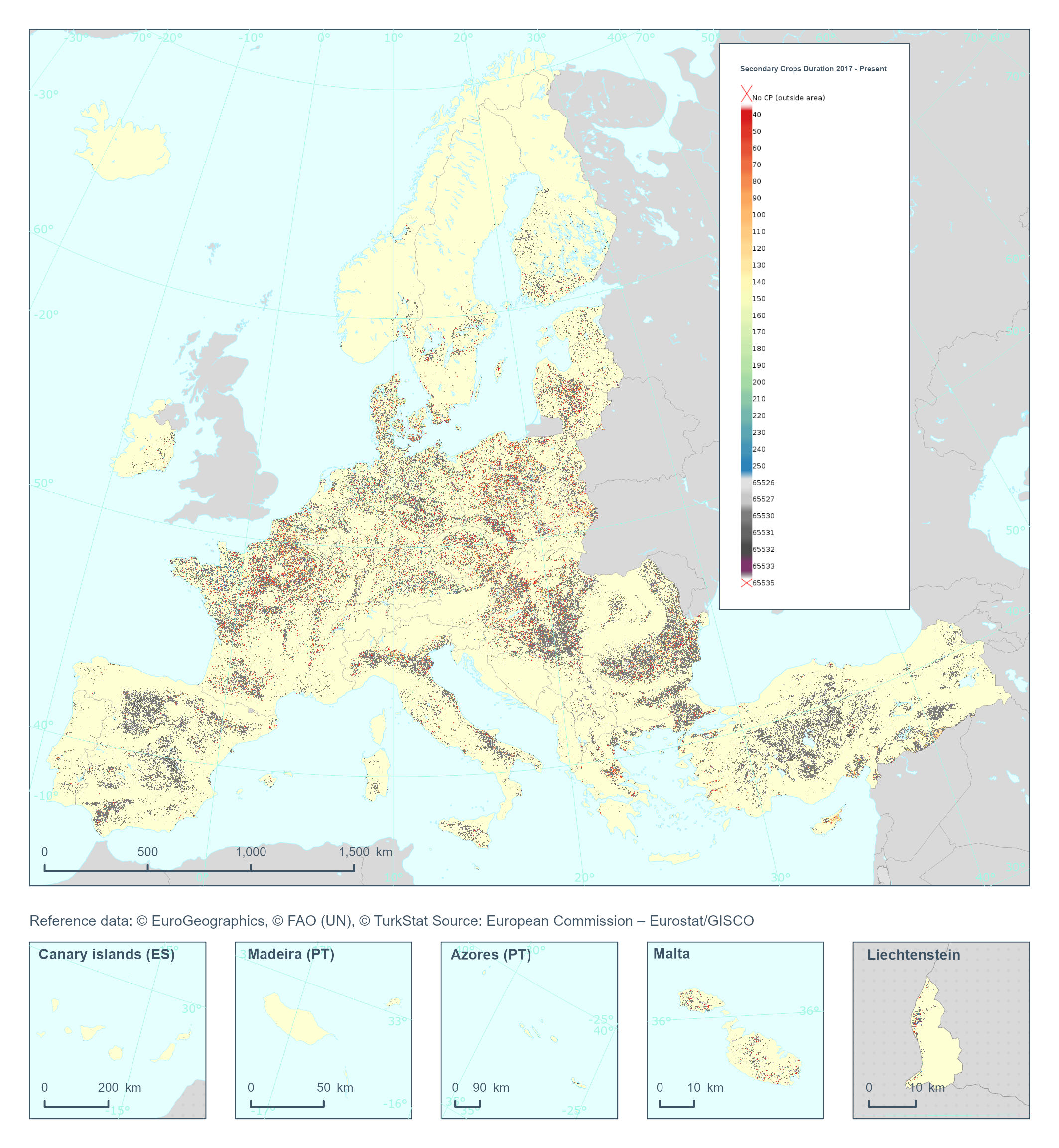
The High Resolution Layer Cropping Patterns - Secondary Crop Duration (CPSCD) raster product provides the duration (in days) of the cover crop season (can exceed the calendar year). This dataset is provided annually starting in 2017 with 10 meter rasters (fully conformant with the EEA reference grid) in 100 x 100 km tiles covering the EEA38 countries. High Resolution Layer Croplands product is part of the European Union’s Copernicus Land Monitoring Service. Confidence layer available for the dataset. This dataset includes data from the French Overseas Territories (DOMs)
-
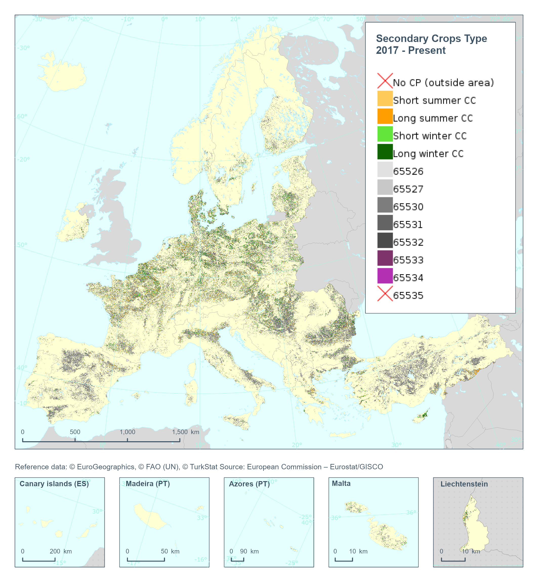
The High Resolution Layer Cropping Patterns - Secondary Crop Type (CPSCT) raster product indicates if a cover crop was present within the respective calendar year and further segregates the types of cover crop into: short summer, long summer, short winter and long winter cover crop. This dataset is provided annually starting in 2017 with 10 meter rasters (fully conformant with the EEA reference grid) in 100 x 100 km tiles covering the EEA38 countries. High Resolution Layer Croplands product is part of the European Union’s Copernicus Land Monitoring Service. Confidence layer available for the dataset. This dataset includes data from the French Overseas Territories (DOMs)
-
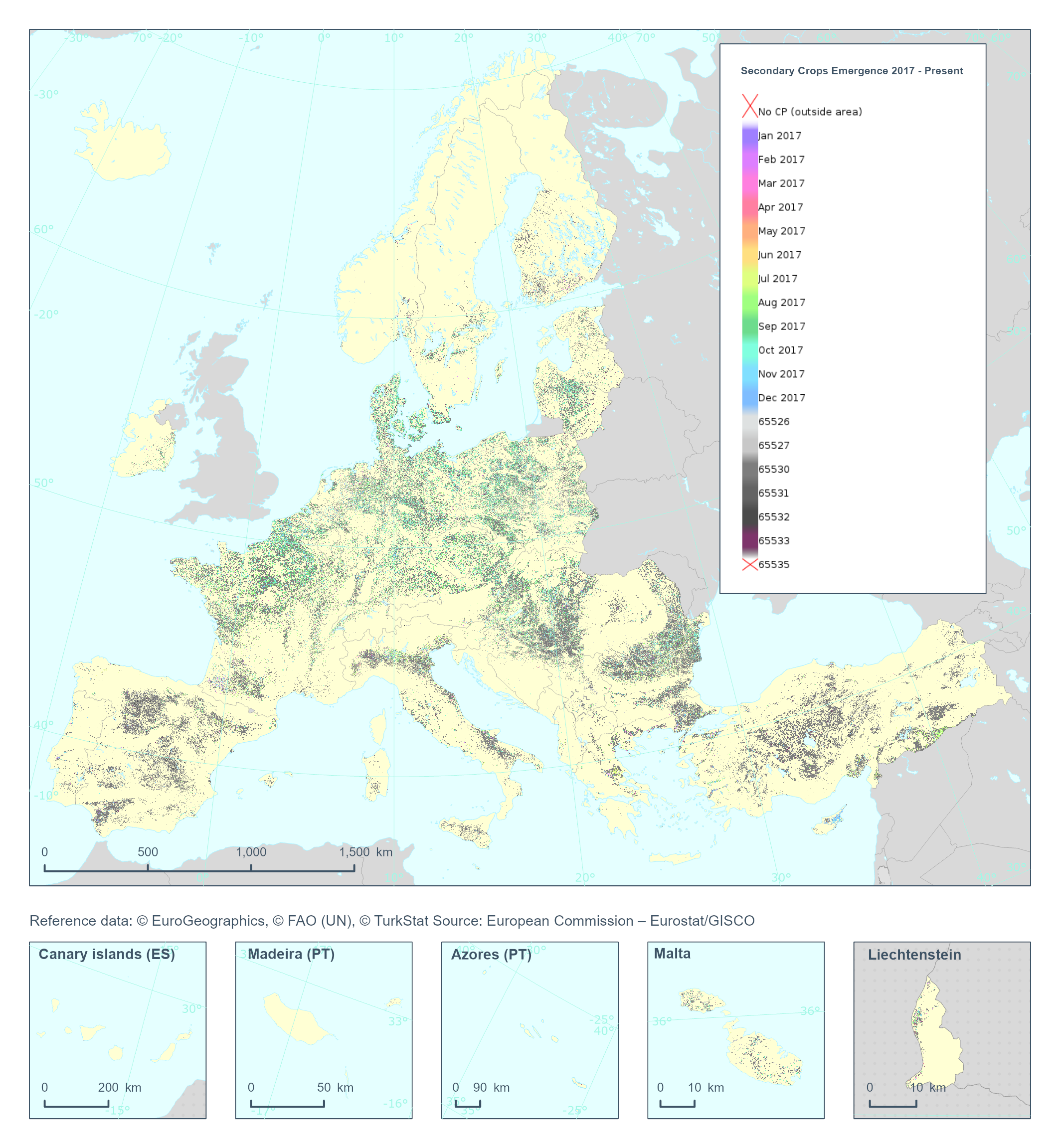
The High Resolution Layer Cropping Patterns - Secondary Crop Emergence (CPSCE) raster product provides the date of emergence of the cover crop in days of the year (DOY). YYDOY where YY = last 2 digits of the year (e.g. 19 for 2019) and DOY is the day of the year (1-365) This dataset is provided annually starting in 2017 with 10 meter rasters (fully conformant with the EEA reference grid) in 100 x 100 km tiles covering the EEA38 countries. High Resolution Layer Croplands product is part of the European Union’s Copernicus Land Monitoring Service. Confidence layer available for the dataset. This dataset includes data from the French Overseas Territories (DOMs)
-
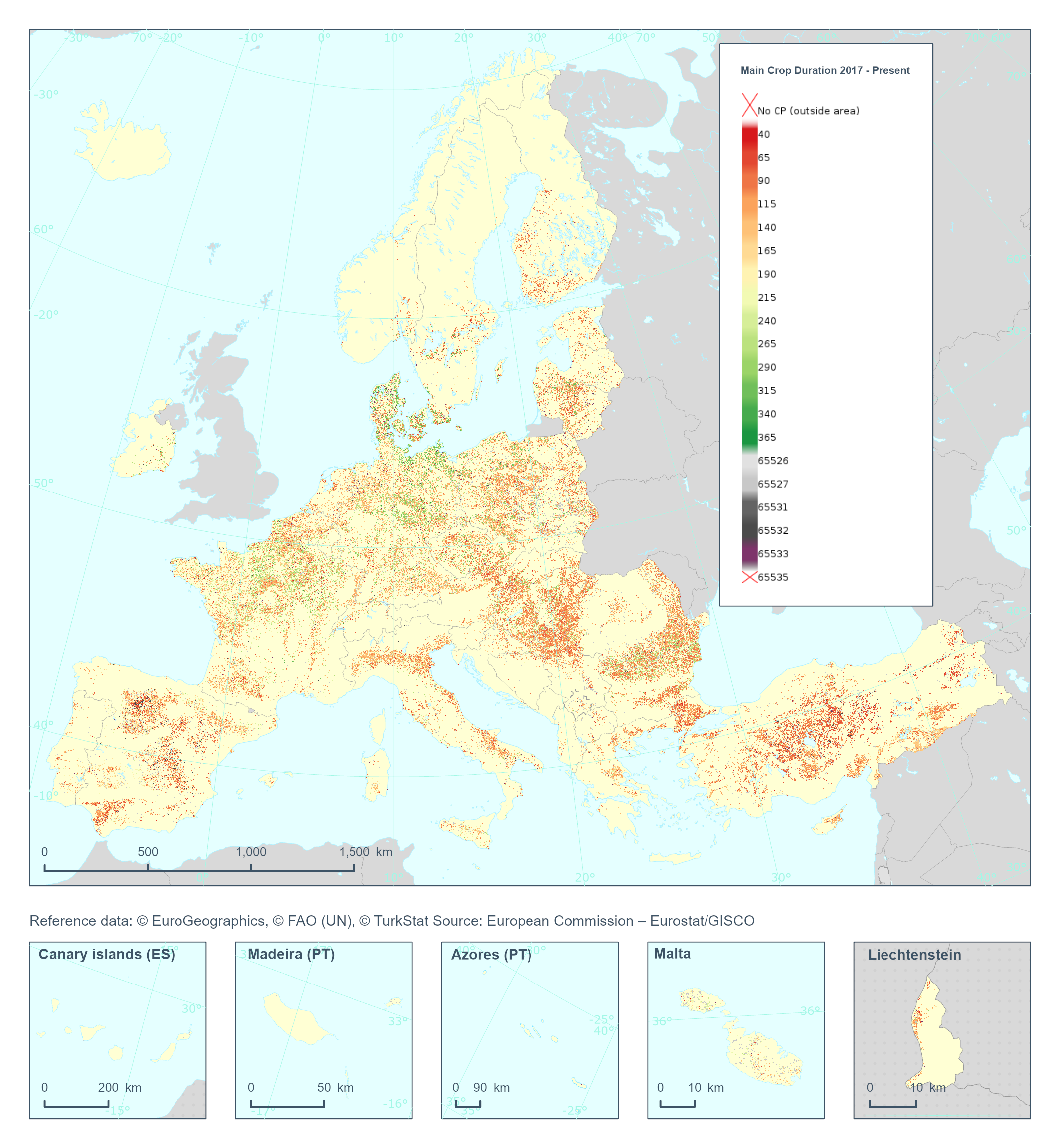
The High Resolution Layer Cropping Patterns - Main Crop Duration (CPMCD) raster product provides the duration (in days) of the growing season for the main (annual) crop. This dataset is provided annually starting in 2017 with 10 meter rasters (fully conformant with the EEA reference grid) in 100 x 100 km tiles covering the EEA38 countries. High Resolution Layer Croplands product is part of the European Union’s Copernicus Land Monitoring Service. Confidence layer available for the dataset. This dataset includes data from the French Overseas Territories (DOMs)
-
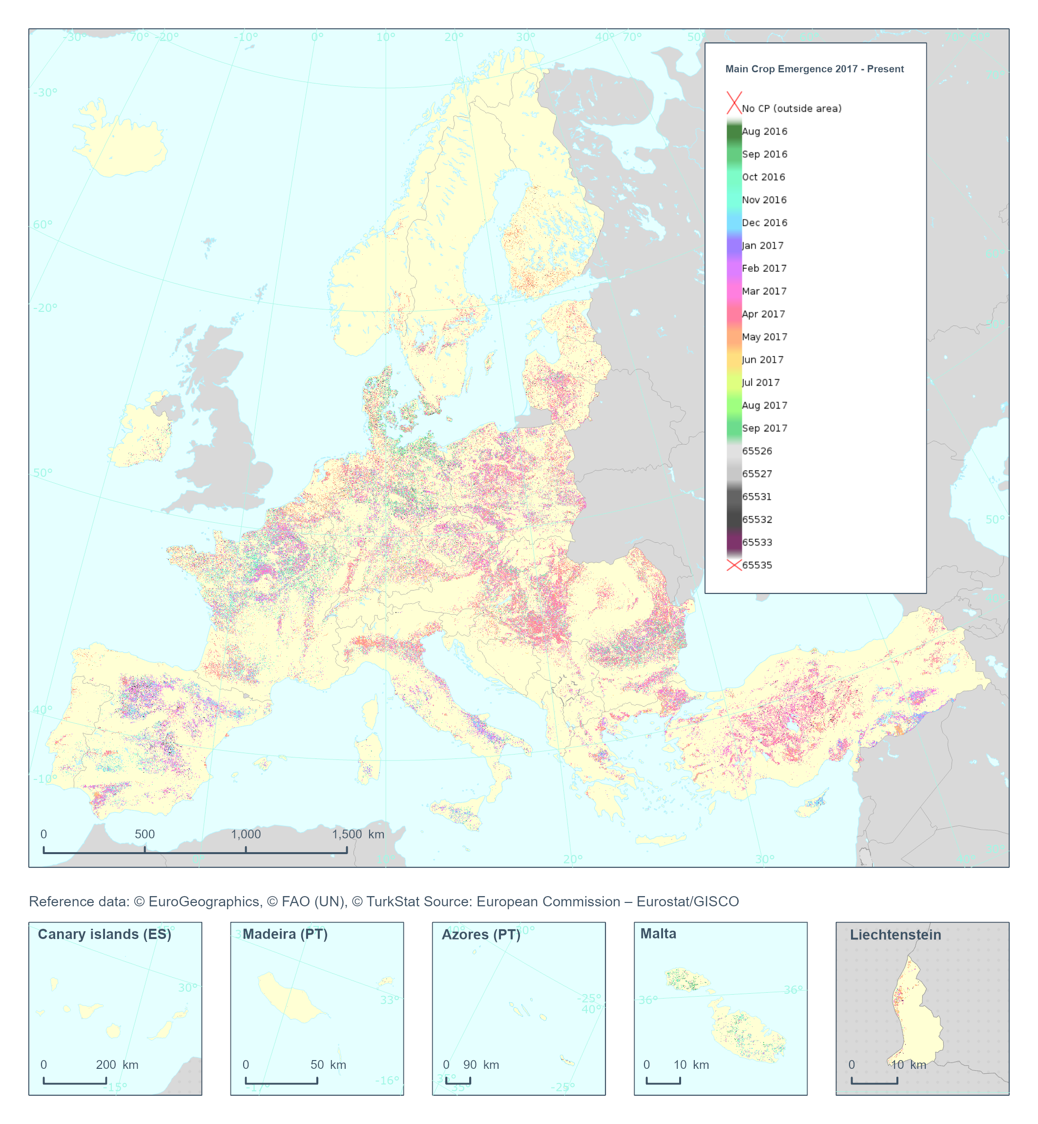
The High Resolution Layer Cropping Patterns - Main Crop Emergence (CPMCE) raster product provides the emergence date of the main (annual) crop expressed in DOY (day of year). YYDOY where YY = last 2 digits of the year (e.g. 19 for 2019) and DOY is the day of the year (1-365). This dataset is provided annually starting in 2017 with 10 meter rasters (fully conformant with the EEA reference grid) in 100 x 100 km tiles covering the EEA38 countries. High Resolution Layer Croplands product is part of the European Union’s Copernicus Land Monitoring Service. Confidence layer available for the dataset. This dataset includes data from the French Overseas Territories (DOMs)
-
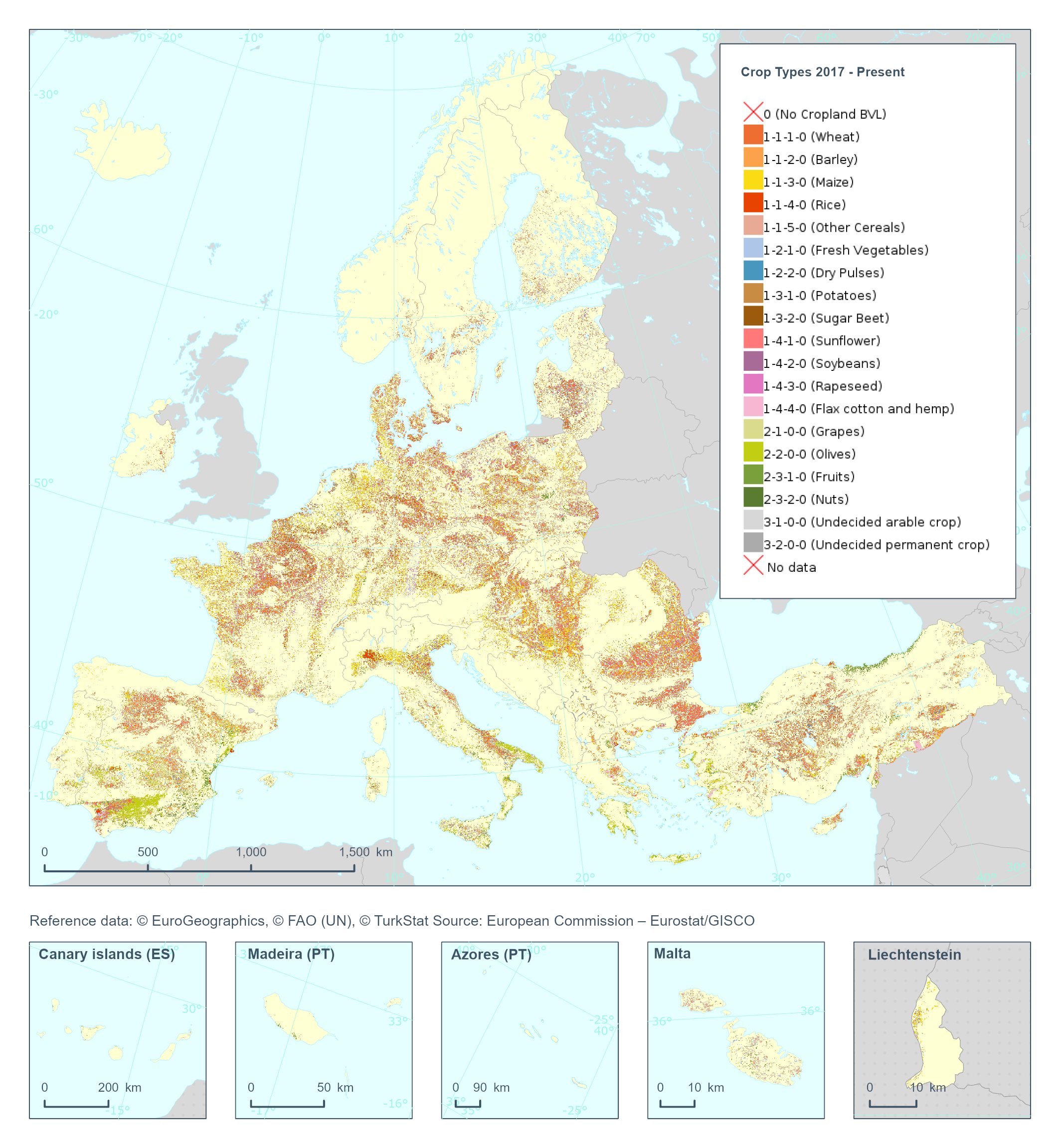
The High Resolution Layer Crop Types (CTY) raster product provides high resolution crop type classification for 17 classes of both arable and permanent crops accross the EEA38 extent. Using both Sentinel-1 and Sentiel-2, the model is finetuned to first map the crop field boundaries, and then determine the main crop for each field. This dataset is provided annually starting in 2017 with 10 meter rasters (fully conformant with the EEA reference grid) in 100 x 100 km tiles covering the EEA38 countries. High Resolution Layer Croplands product is part of the European Union’s Copernicus Land Monitoring Service. Confidence layer available for the dataset. This dataset includes data from the French Overseas Territories (DOMs)
-
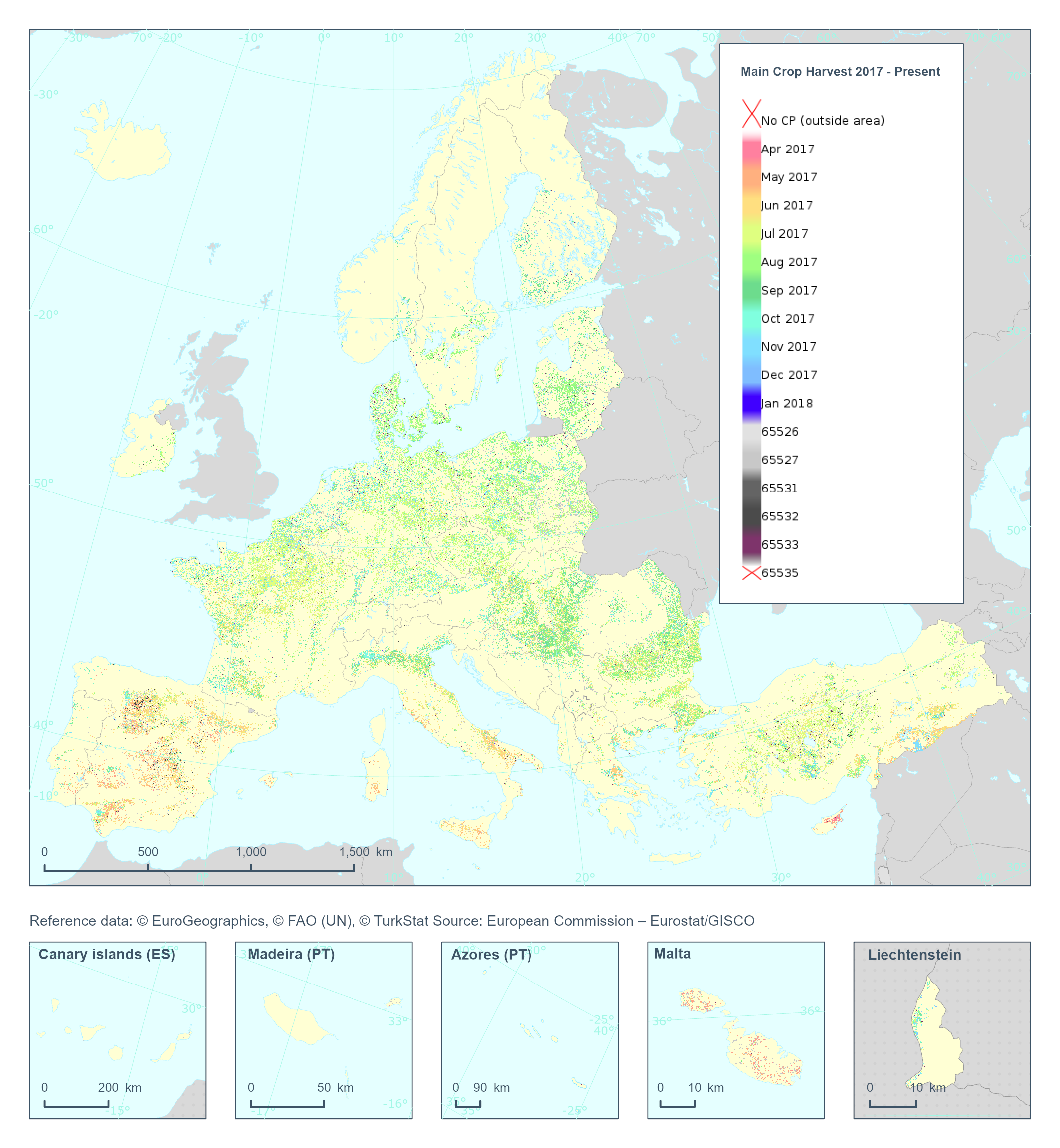
The High Resolution Layer Cropping Patterns - Main Crop Harvest (CPMCH) raster product provides the harvest date of the main (annual) crop expressed in days of the year (DOY). The harvest is considered as the time of removal of most of the biomass. YYDOY where YY = last 2 digits of the year (e.g. 19 for 2019) and DOY is the day of the year (1-365) This dataset is provided annually starting in 2017 with 10 meter rasters (fully conformant with the EEA reference grid) in 100 x 100 km tiles covering the EEA38 countries. High Resolution Layer Croplands product is part of the European Union’s Copernicus Land Monitoring Service. Confidence layer available for the dataset. This dataset includes data from the French Overseas Territories (DOMs)
-

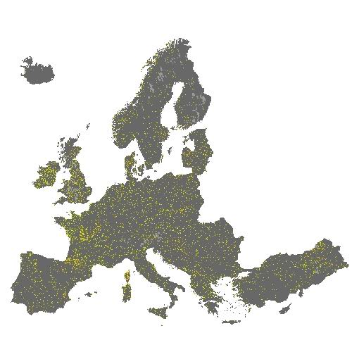
The HRL Small Woody Features (SWF) is a new Copernicus Land Monitoring Service (CMLS) product, which provides harmonized information on linear structures such as hedgerows, as well as patches (200 m² ≤ area ≤ 5000 m²) of woody features across the EEA39 countries. Small woody landscape features are important vectors of biodiversity and provide information on fragmentation of habitats with a direct potential for restoration while also providing a link to hazard protection and green infrastructure, amongst others. The SWF layer contains woody linear, and small patchy elements, but is not differentiated into trees, hedges, bushes and scrub. The spatial pattern are limited to linear structures and isolated patches (patchy structures) on the basis of geometric characteristics. Additional Woody Features (AWF) are also included in this product. They consist of woody structures that do not fulfil the SWF geometric specifications but which are connected to valid SWFs structures. VHR imagery (DEIMOS-2, Pleiades 1A, Pleiades 1B, GeoEye-1, SPOT 6, SPOT 7, WorldView-2, WorldView-3 images from 2015) made available in the ESA Copernicus DWH are the main data source for the detection of small woody features identifiable within the given image resolution. The dataset is available for the 2015 reference year and is produced in three different formats. This metadata corresponds to the SWF 100m spatial resolution raster aggregate layers: SWF density (0 – 100 %), AWF density (0 – 100 %) and SWF+AWF density (0 – 100 %). The SWF 100m raster layer, consistent with the EEA 100m grid, is a 100m aggregated version of the SWF 5m raster layer. It can be used as a landscape descriptor of SWF density for large areas.
-
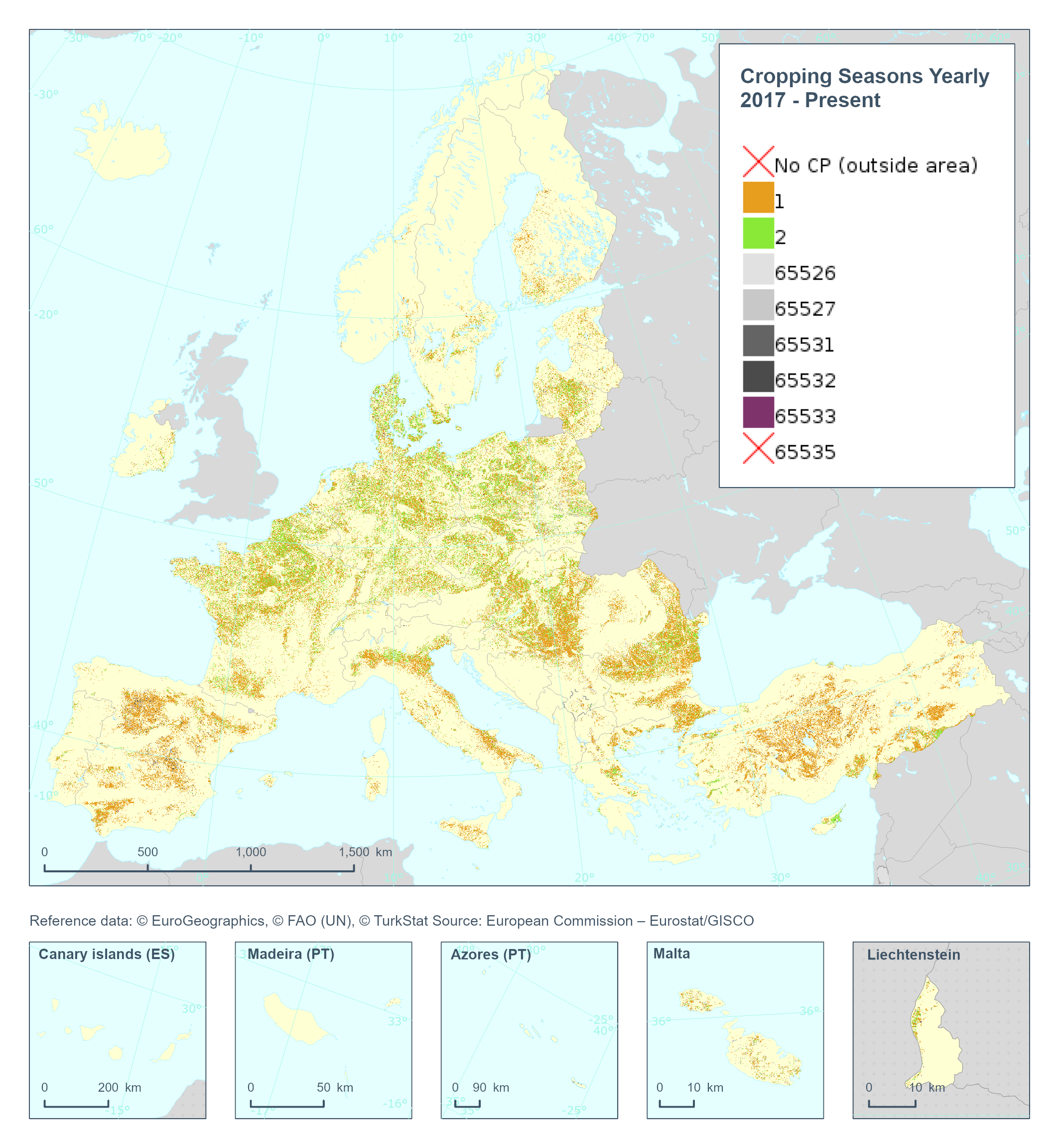
The High Resolution Layer Cropping Patterns - Cropping Seasons Yearly (CPCSY) raster product provides number of growing seasons detected within 1 year (0/1/2). This dataset is provided annually starting in 2017 with 10 meter rasters (fully conformant with the EEA reference grid) in 100 x 100 km tiles covering the EEA38 countries. High Resolution Layer Croplands product is part of the European Union’s Copernicus Land Monitoring Service. This dataset includes data from the French Overseas Territories (DOMs)
-
The HRL Small Woody Features (SWF) is a new Copernicus Land Monitoring Service (CMLS) product, which provides harmonized information on linear structures such as hedgerows, as well as patches (200 m² ≤ area ≤ 5000 m²) of woody features across the EEA39 countries. Small woody landscape features are important vectors of biodiversity and provide information on fragmentation of habitats with a direct potential for restoration while also providing a link to hazard protection and green infrastructure, amongst others. The SWF layer contains woody linear, and small patchy elements, but is not differentiated into trees, hedges, bushes and scrub. The spatial pattern are limited to linear structures and isolated patches (patchy structures) on the basis of geometric characteristics. Additional Woody Features (AWF) are also included in this product. They consist of woody structures that do not fulfil the SWF geometric specifications but which are connected to valid SWFs structures. VHR imagery (DEIMOS-2, Pleiades 1A, Pleiades 1B, GeoEye-1, SPOT 6, SPOT 7, WorldView-2, WorldView-3 images from 2015) made available in the ESA Copernicus DWH are the main data source for the detection of small woody features identifiable within the given image resolution. The dataset is available for the 2015 reference year and is produced in three different formats. This metadata corresponds to the SWF vector layer, which separates the SWF class into Linear (code = 1) and Patchy (code = 2). Additional Woody Features are represented with code = 3. This is the primary product of the Small Woody Features mapping, and thus also the one with most detail. The vector data set can be downloaded in Geodatabase and Geopackage formats.