 Arctic SDI catalogue
vegetation
Type of resources
Available actions
Topics
Keywords
Contact for the resource
Provided by
Years
Formats
Representation types
Update frequencies
status
Service types
Scale
Resolution
-

Dataset featuring the spatial location of vegetation management (silvicultural herbicides) treatments on provincial Crown Lands. The dataset is a historical record of silvicultural herbicide treatments which is used to inform the history of forest management activities on provincial Crown lands.
-
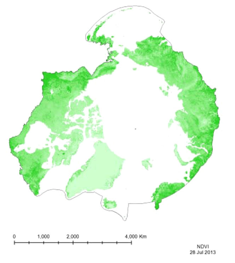
Vegetation indices quantify the concentrations of green leaf vegetation (chlorophyll)around the globe, in an attempt to monitor and correlate vegetation health and stress. The MODIS vegetation products include the Normalized Difference Vegetation Index (NDVI)and an Enhanced Vegetation Index (EVI). Included in the MOD13C1 product is both NDVIand EVI, so both have been provided for the CAFF Dedicated Pan-Arctic Satellite RemoteSensing Products and Distribution System. These indices come in a variety of resolutions,but MTRI has provided a monthly global composite on a 0.05° Climate Model GRID(CMG).
-
Dataset featuring the spatial location of vegetation management (silvicultural herbicides) treatments on provincial Crown Lands. The dataset is a historical record of silvicultural herbicide treatments which is used to inform the history of forest management activities on provincial Crown lands.
-

In 2013, the Ontario Ministry of the Environment, Conservation and Parks initiated an integrated baseline environmental data collection program in the Ring of Fire region located in Ontario’s Far North. The program was designed to establish baseline or reference environmental conditions for this region of Ontario. The program was comprised of four main integrated components: - surface water (lakes and streams) monitoring (2013-2018) - peat pore water (groundwater) monitoring (2013-2018) - terrestrial (vegetation and soil) monitoring (2013-2018) - air monitoring (2015-2018) Data collection activities were generally located within 60 km of the Noront Resources/Cliffs Natural Resources mining exploration camp established near Koper Lake and within the Attawapiskat, Ekwan, and Winisk River watersheds. The baseline monitoring activities were integrated or co-located where possible to provide more comprehensive datasets on the dominant ecosystems for this part of Ontario.
-
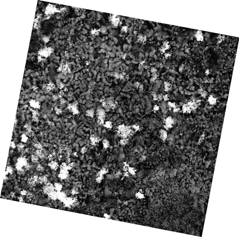
The 1 cm resolution vegetation digital height model was extracted using a bare earth model and digital surface model (DSM) derived from unmanned aerial vehicle (UAV) imagery acquired from a single day survey on July 28th 2016, in Cambridge Bay, Nunavut. The mapping product covers 525m2 and was produced by Canada Centre for Remote Sensing /Canada Centre for Mapping and Earth Observation. The UAV survey was completed in collaboration with the Canadian High Arctic Research Station (CHARS) for northern vegetation monitoring research. For more information, refer to our current Arctic vegetation research: Fraser et al; "UAV photogrammetry for mapping vegetation in the low-Arctic" Arctic Science, 2016, 2(3): 79-102. http://www.nrcresearchpress.com/doi/abs/10.1139/AS-2016-0008
-
Bird and distance transect biodiversity GRID data from Barrow, Alaska-
-
Created for distribution by the GeoYukon application as a comprehensive resource for all publicly available Base Data information in the Yukon government. This data may be used directly by other applications to dynamically display Yukon data; however, it may be subject to change as data sets are updated or added.
-

A list of the site series ecological units of the current biogeoclimatic ecosystem classification. It is consistent with the biogeoclimatic subzone/variant map (BEC_BIOGEOCLIMATIC_POLY, version 13.1, July 8, 2026). Site series are subdivisions of the biogeoclimatic subzone/variant, and describe sites capable of producing the same mature or climax vegetation unit (plant association or sometimes, subassociation). Site series are described in the Regional Field Guides to Site Identification. Site and soil conditions, and the vegetation community, are used to identify site series
-

CryoGeographic Consulting, in association with Palmer Environmental Consulting Group Inc., provided Yukon Energy, Mines and Resources and Yukon Environment with the results of the mapping and classification of wetlands and adjacent upland habitat in the Indian River valley and its major tributaries. This report and its accompanying map set have been updated to reflect study area expansion and additional field reconnaissance completed in the summer of 2017. Interpretation of shallow water wetlands within disturbed landscapes was completed by Ducks Unlimited Canada and incorporated. Five classes of wetlands are distinguished - bogs, fens, swamps, marshes and shallow water - based on field investigations and interpretation of high-resolution aerial photography and satellite imagery. The accompanying report w it h full metadata can be downloaded from: [https://yukon.ca/en/mapping-and-classifying-wetlands-indian-river-valley-yukon](https://yukon.ca/en/mapping-and-classifying-wetlands-indian-river-valley-yukon) Distributed from [GeoYukon](https://yukon.ca/geoyukon) by the [Government of Yukon](https://yukon.ca/maps) . Discover more digital map data and interactive maps from Yukon's digital map data collection. For more information: [geomatics.help@yukon.ca](mailto:geomatics.help@yukon.ca)
-
A list of the various 'regional' (zone/subzone/variant/phase) ecological units of the current biogeoclimatic ecosystem classification. It is consistent with the biogeoclimatic subzone/variant map (BEC_BIOGEOCLIMATIC_POLY, version 13.1, July 8, 2026). At this 'regional' level, vegetation, soils and topography are used to infer the climate and to identify geographic areas that have relatively uniform climate. These geographic areas are termed biogeoclimatic units. The basic biogeoclimatic unit is the Subzone. These units are grouped into Zones and may be further subdivided into variants based on further refinements of climate (e.g., wetter, drier, snowier). The map units of the Biogeoclimatic map are mapped to the highest possible thematic resolution - subzone or variant. In some cases, where further sampling is required to define the unit climatically, polygons are labelled as an undifferentiated unit (e.g. CWH un)