 Arctic SDI catalogue
land
Type of resources
Available actions
Topics
Keywords
Contact for the resource
Provided by
Years
Formats
Representation types
Update frequencies
status
Service types
Scale
Resolution
-
-
Land Tenure for the Yukon Mining and Lands viewers
-
Created for distribution by the GeoYukon application as a comprehensive resource for all publicly available Mining information in the Government of Yukon. This data may be used directly by other applications to dynamically display Yukon data; however, it may be subject to change as data sets are updated or added.
-

Land Features entities are: Island, Shoreline, Wooded Area, Saturated soil, Landform Feature (esker, sand\...), and Cut Line. CanVec is a digital cartographic reference product of Natural Resources Canada (NRCan). It originates from the best available data sources covering Canadian territory, offers quality topographical information in vector format, and complies with international geomatics standards. CanVec is a multi-source product coming mainly from the National Topographic Data Base (NTDB), the Mapping the North process conducted by the Canada Center for Mapping and Earth Observation (CCMEO), the Atlas of Canada data, the GeoBase initiative, and the data update using satellite imagery coverage (e.g. Landsat 7, Spot, Radarsat, etc.). Distributed from [GeoYukon](https://yukon.ca/geoyukon) by the [Government of Yukon](https://yukon.ca/maps) . Discover more digital map data and interactive maps from Yukon's digital map data collection. For more information: [geomatics.help@yukon.ca](mailto:geomatics.help@yukon.ca)
-
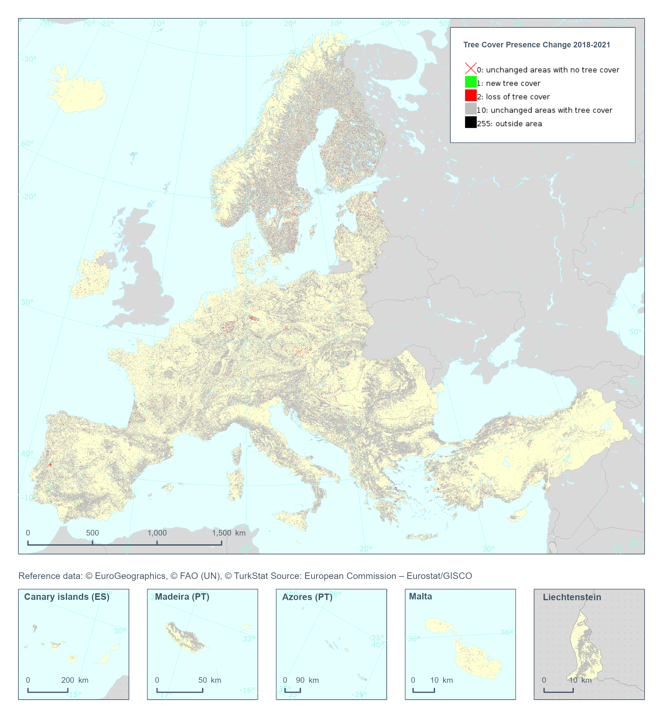
The Copernicus High Resolution Layer Tree Cover Precense Change (TCPC) 2018-2021 raster product provides information on the change between the reference years 2018 and 2021 and consists of 4 thematic classes (unchanged areas with no tree cover / new tree cover / loss of tree cover / unchanged areas with tree cover). The class 255 = outside area is predefined by the 100m boundary layer and remains unchanged. This layer for previous reference year compraissions is called Tree Cover Change Mask (TCCM). This dataset is provided in 20 meter rasters (fully conformant with the EEA reference grid) in 100 x 100 km tiles covering the EEA38 countries. The production of the high resolution forest layers was coordinated by the European Environment Agency (EEA) in the frame of the EU Copernicus programme. Confidence layer available for the dataset. This dataset includes data from the French Overseas Territories (DOMs)
-

To identify the limits of provincial parks in New Brunswick, to provide the public with a digital representation of the provincial parks, and to promote the use of a common geometric representation of the provincial parks of New Brunswick.
-
Land under administration and control of Government of Yukon and disposed of by the Department of Energy, Mines and Resources (EMR), Land Management Branch in the form of active licences of occupation. A licence grants permission to do something which without the licence would not be allowable. Land Management Branch licences typically permit the construction and maintenance of power, telephone, water or sewer utilities on Commissioner's land. Licences of occupation are linear in nature and often extend long distances, hence the requirement for a separate feature class. Distributed from [GeoYukon](https://yukon.ca/geoyukon) by the [Government of Yukon](https://yukon.ca/maps) . Discover more digital map data and interactive maps from Yukon's digital map data collection. For more information: [geomatics.help@yukon.ca](mailto:geomatics.help@yukon.ca)
-
The Aboriginal Lands dataset consists of polygon entities that depict the administrative boundaries (extent) of lands where the title has been vested in specific Aboriginal Groups of Canada or lands which were set aside for their exclusive benefit.
-
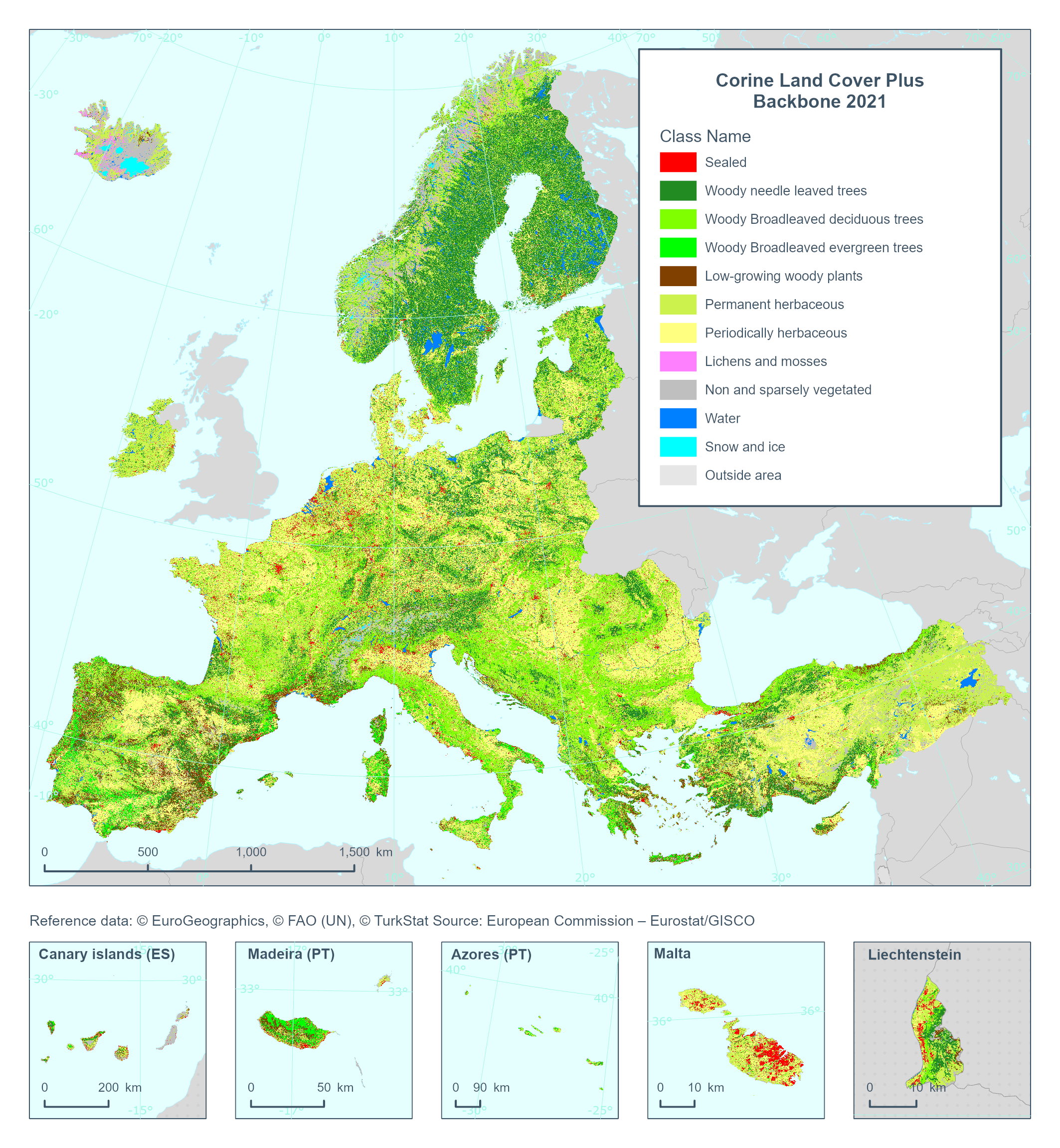
This metadata refers to the 'Corine Land Cover plus Backbone' (CLCplus Backbone), a spatially detailed, large-scale, Earth Observation-based land cover inventory which is produced by the Copernicus Land Monitoring Service (CLMS). The CLCplus Backbone is a 10m pixel-based land cover map based on Sentinel satellite time series. Each pixel contains the dominant land cover among the 11 basic land cover classes. See pixel class codes in the additional information section. The product has an update cycle of three years and starting from the 2018 reference year. The update cycle for future products (from 2021 reference year onwards) will be 2 years.
-

High Resolution land cover characteristics for the 2018 reference year. Small woody landscape features are important vectors of biodiversity and provide information on fragmentation of habitats with a direct potential for restoration while also providing a link to hazard protection and green infrastructure, amongst others. VHR_IMAGE_2018 made available in the ESA Copernicus DWH will be the main data source for the detection of small woody features identifiable within the given image resolution. The Small Woody Features (SWFs) layer contains woody linear and patchy elements but will not be further differentiated into trees, hedges, bushes and scrub. The spatial pattern shall be limited to linear structures and isolated patches on the basis of geometric characteristics.