 Arctic SDI catalogue
Bacteria
Type of resources
Available actions
Topics
Keywords
Contact for the resource
Provided by
Formats
Representation types
Update frequencies
status
Scale
-
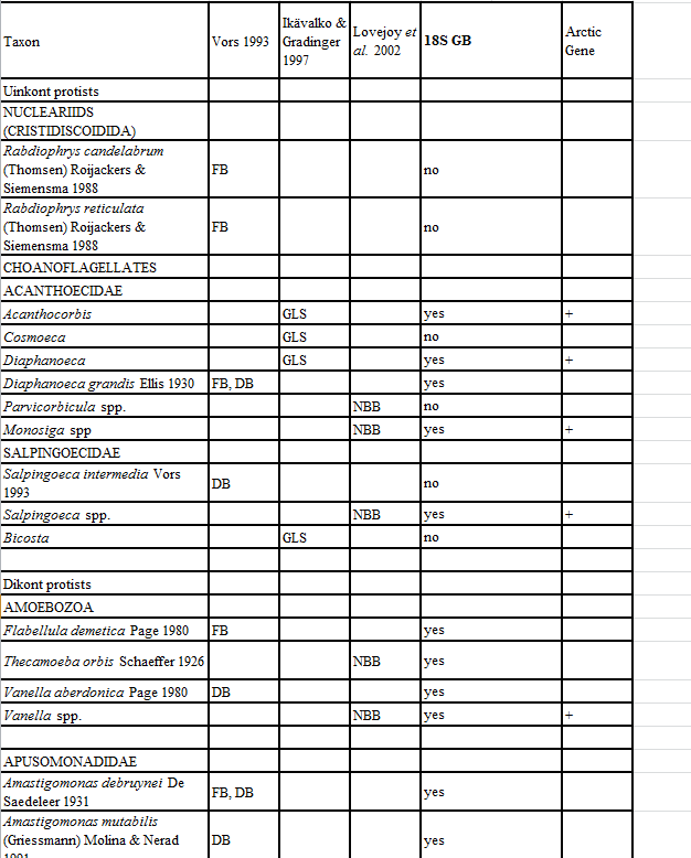
Appendix 11. Taxa of hetorotrophic protists reported from Foxe Basin, Canada (FB), Disko Bay, W Greenland (DB; Vors 1993), the Greenland Sea (GLS; Ikävalko & Gradinger 1997) and Northern Baffin Bay, Canada (NBB; Lovejoy et al. 2002).
-
The objective of this project was to gather data to develop a model of the food web of the lower trophic levels of the nearshore area of the Beaufort Sea. Sampling took place from 2005 to 2008 using the CCGS Nahidik. The multidisciplinary character of the Nahidik program produced measurements of biology/ecology (primary production, phytoplankton, zooplankton, benthos, fish), chemical and physical oceanography, contaminants, geology and hydro acoustics. The data were collected in July and August of each year. The Nahidik program provided data to provide a baseline for future studies as well as an information source for environmental assessment.
-

Bay-scale empirical demonstrations of how bivalve aquaculture alters plankton composition, and subsequently ecological functioning and higher trophic levels, are lacking. Temporal, inter- and within-bay variation in hydrodynamic, environmental, and aquaculture pressure limit efficient plankton monitoring design to detect bay-scale changes and inform aquaculture ecosystem interactions. Here, we used flow cytometry to investigate spatio-temporal variations in bacteria and phytoplankton (< 20 µm) composition in four bivalve aquaculture embayments. We observed higher abundances of bacteria and phytoplankton in shallow embayments that experienced greater freshwater and nutrient inputs. Depleted nutrient conditions may have led to the dominance of picophytoplankton cells, which showed strong within-bay variation as a function of riverine vs freshwater influence and nutrient availability. Although environmental forcings appeared to be a strong driver of spatio-temporal trends, results showed that bivalve aquaculture may reduce near-lease phytoplankton abundance and favor bacterial growth. We discuss aquaculture pathways of effects such as grazing, benthic-pelagic coupling processes, and microbial biogeochemical cycling. Conclusions provide guidance on optimal sampling considerations using flow cytometry in aquaculture sites based on embayment geomorphology and hydrodynamics. Cite this data as: Sharpe H, Lacoursière-Roussel A, Barrell J (2024). Monitoring bay-scale bivalve aquaculture ecosystem interactions using flow cytometry. Version 1.2. Fisheries and Oceans Canada. Samplingevent dataset. https://ipt.iobis.org/obiscanada/resource?r=monitoring_bay-scale_bivalve_aquaculture_ecosystem_interactions_using_flow_cytometry&v=1.2
-

This record contains results from chemical analysis including suspended nitrogen (mg/g), suspended carbon (mg/g), and phosphorus (mg/g) based on dry weight sediment samples collected in the Beaufort Sea.
-

The objective of this project was to gather data to develop a model of the food web of the lower trophic levels of the nearshore area of the Beaufort Sea. Sampling took place from 2005 to 2008 using the CCGS Nahidik. The multidisciplinary character of the Nahidik program produced measurements of biology/ecology (primary production, phytoplankton, zooplankton, benthos, fish), chemical and physical oceanography, contaminants, geology and hydro acoustics. The data were collected in July and August of each year. The Nahidik program provided data to provide a baseline for future studies as well as an information source for environmental assessment. This record contains the geographic coordinates and station names from 2005 to 2008.
-
The objective of this project was to gather data to develop a model of the food web of the lower trophic levels of the nearshore area of the Beaufort Sea. Sampling took place from 2005 to 2008 using the CCGS Nahidik. The multidisciplinary character of the Nahidik program produced measurements of biology/ecology (primary production, phytoplankton, zooplankton, benthos, fish), chemical and physical oceanography, contaminants, geology and hydro acoustics. The data were collected in July and August of each year. The Nahidik program provided data to provide a baseline for future studies as well as an information source for environmental assessment. This record contains water chemistry data collected as part of this project including suspended nitrogen, dissolved nitrogen, suspended phosphorus, dissolved phosphorus, dissolved organic carbon, suspended carbon, chlorophyll a, and suspended silicon.
-

In 2018, Fisheries and Oceans Canada initiated the Multidisciplinary Arctic Program (MAP) – Last Ice, the first ecosystem study of the poorly characterized region of the Lincoln Sea in the Marine Protected Area of Tuvaijuittuq, where multiyear ice still resides in the Arctic Ocean. MAP-Last Ice takes a coordinated approach to integrate the physical, biochemical, and ecological components of the sea ice-ocean connected ecosystem and its response to climate and ocean forcings. The cross-disciplinary program establishes baseline ecological knowledge for Tuvaijuittuq and, in particular, for its unique multiyear ice ecosystem. The database provides baseline data on the abundance of bacteria and viruses in multi- and first-year ice and in surface waters of the Lincoln Sea in Tuvaijuittuq, and their relation to bio-physical conditions. The data were collected during the 2018 spring field campaign of the MAP-Last Ice Program, at an ice camp offshore of Canadian Forces Station (CFS) Alert.
-

This record contains information on the samples collected and the intended parameters for analysis from sediment cores collected as part of this project including bacteria, chemistry, stable isotopes, fatty acids, or meiofauna.
-
Northern Marine Coastal and Ecosystem Studies in the Canadian Beaufort Sea- sediment stable isotopes

This record contains results from stable isotope analysis of sediment samples including δ 13C (‰), δ 15N (‰), total N and total C collected in the Beaufort Sea.
-
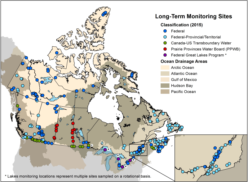
Long-term freshwater quality data from federal and federal-provincial sampling sites throughout Canada's aquatic ecosystems are included in this dataset. Measurements regularly include physical-chemical parameters such as temperature, pH, alkalinity, major ions, nutrients and metals. Collection includes data from active sites, as well as historical sites that have a period of record suitable for trend analysis. Sampling frequencies vary according to monitoring objectives. The number of sites in the network varies slightly from year-to-year, as sites are adjusted according to a risk-based adaptive management framework. The Great Lakes are sampled on a rotation basis and not all sites are sampled every year. Data are collected to meet federal commitments related to transboundary watersheds (rivers and lakes crossing international, inter-provincial and territorial borders) or under authorities such as the Department of the Environment Act, the Canada Water Act, the Canadian Environmental Protection Act, 1999, the Federal Sustainable Development Strategy, or to meet Canada's commitments under the 1969 Master Agreement on Apportionment.