 Arctic SDI catalogue
Birds
Type of resources
Available actions
Topics
Keywords
Contact for the resource
Provided by
Formats
Representation types
Update frequencies
status
-
The Great Lakes Coastal Wetland Monitoring Program (GLCWMP) involves the monitoring of Great Lakes coastal wetland biota and habitat to provide information on coastal wetland condition for use in conservation and management decision-making using fish, birds, anurans, vegetation, aquatic macroinvertebrates and water quality. The main outputs from this program are a thorough assessment of the condition of over 1000 Great Lakes coastal wetlands (that are larger than four hectares in size and have a surface water connection to the lake) and the implementation of a standardized long-term monitoring program for coastal wetlands across the Great Lakes basin. This program is funded under the Great Lakes Restoration Initiative by the U.S. Environmental Protection Agency, Great Lakes National Program Office (GLNPO). The Canadian Wildlife Service (CWS) of Environment and Climate Change Canada has been involved in the program since it began in 2011, and over that time has conducted fish, vegetation, aquatic macroinvertebrates and water quality surveys at 80 coastal wetland sites (as of 2025) primarily on the Canadian shore of Lake Ontario. Program data are available by request at: www.greatlakeswetlands.org. The data included here are a list of the 80 sites surveyed by CWS, spatial coordinates for each site, and the years that sites were surveyed.
-
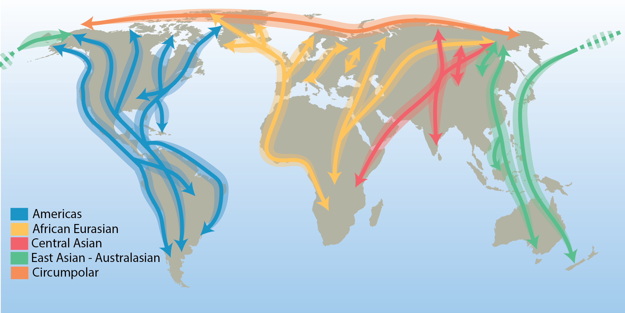
There are few true Arctic specialist birds that remain in the Arctic throughout their annual cycle. They include the willow and rock ptarmigan (Lagopus lagopus and L. muta), gyrfalcon (Falco rusticolus), snowy owl (Bubo scandiacus), Arctic redpoll (Carduelis hornemanni) and northern raven (Corvus corax)—a cosmopolitan species with resident populations in the Arctic. All other terrestrial Arctic-breeding bird species migrate to warmer regions during the northern winter, connecting the Arctic to all corners of the globe. Hence, their distributions are influenced by the routes they follow. These distinct migration routes are referred to as flyways and are defined by a combination of ecological and political boundaries and differ in spatial scale. The CBMP refers to the traditional four north–south flyways, in addition to a circumpolar flyway representing the few species that remain largely within the Arctic year-round (Figure 3-20). STATE OF THE ARCTIC TERRESTRIAL BIODIVERSITY REPORT - Chapter 3 - Page 48- Figure 3.20
-
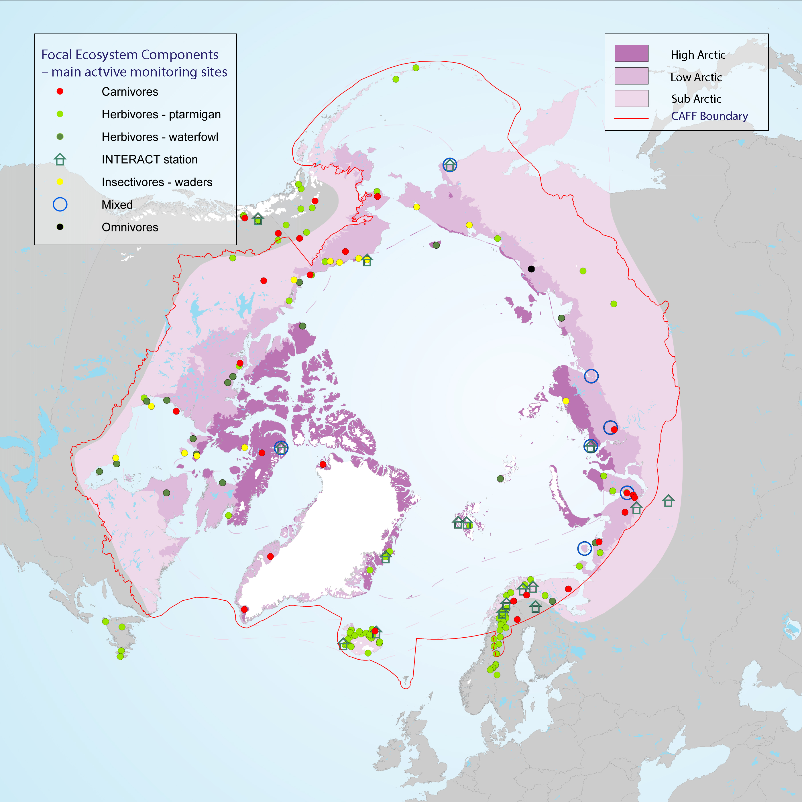
Many population counts of gregarious migrant species, such as waders and geese, take place along the flyways and at wintering grounds outside the Arctic which stresses the importance of continued development of movement ecology studies. Monitoring of FEC attributes related to breeding success and links to environmental drivers within the Arctic takes place in a wide network of research sites across the Arctic, although with low coverage of the high Arctic zone (Figure 3-25) STATE OF THE ARCTIC TERRESTRIAL BIODIVERSITY REPORT - Chapter 3 - Page 58 - Figure 3.25
-
Sidney Island Shorebirds Survey peep counts.
-
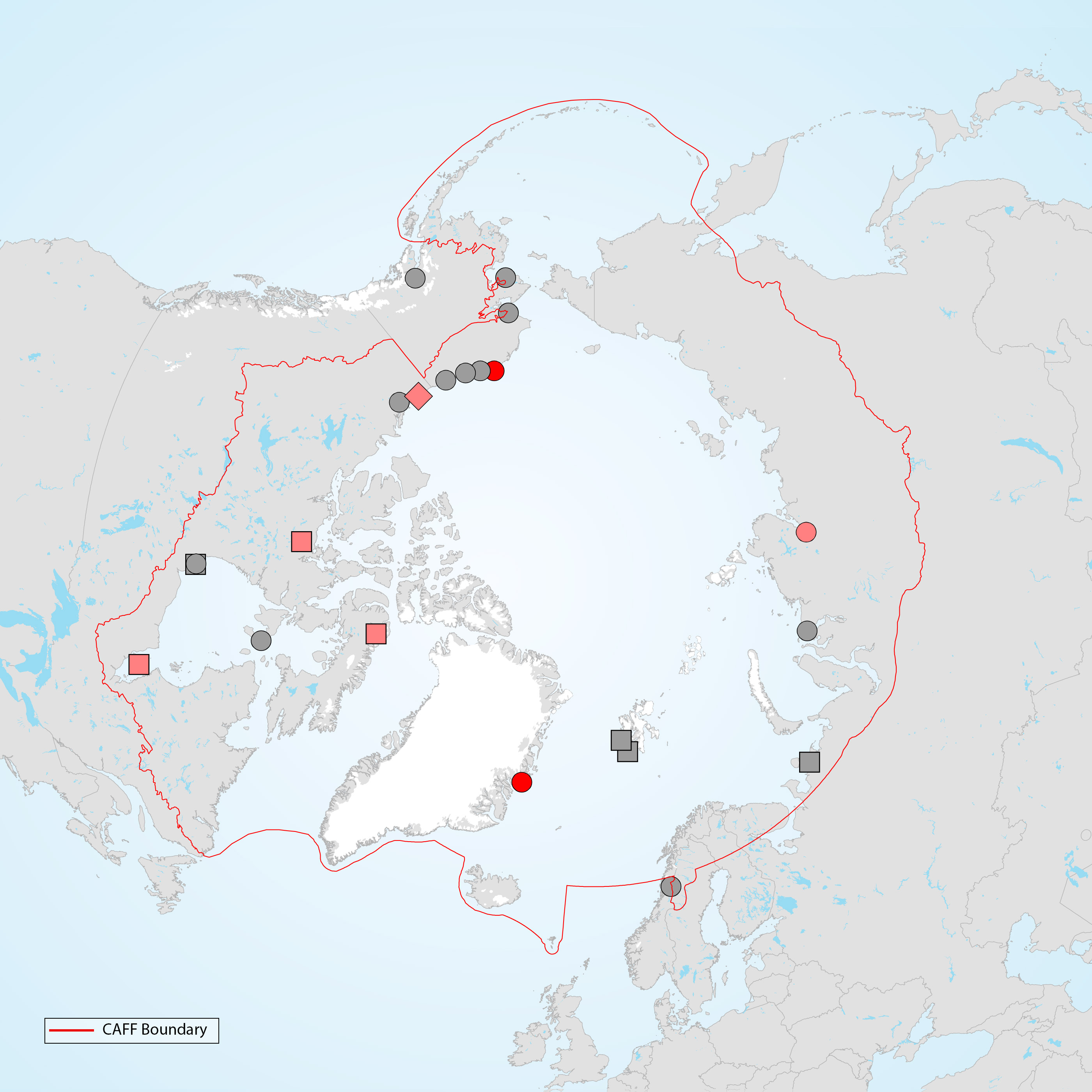
Study sites across the Arctic where phenological mismatches between timing of reproduction and peak abundance in food have been studied for terrestrial bird species. Grey symbols show study sites where this phenomenon has been studied for <10 years, light red symbols show sites with >10 years of data but no strong evidence of an increasing mismatch, and dark red symbols indicate sites with >10 years of data and strong evidence of an increasing mismatch. Circles indicate studies of shorebirds, squares for waterfowl and diamonds(triancle) for both shorebirds and passerines. Graphic: Thomas Lameris, adapted from Zhemchuzhnikov (submitted). STATE OF THE ARCTIC TERRESTRIAL BIODIVERSITY REPORT - Chapter 3 - Page 65 - Figure Box 3.3
-
Surveyor shorebird bird observations and counts for all years.
-
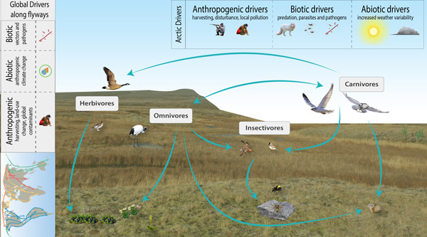
The CBMP–Terrestrial Plan identifies five FECs for monitoring terrestrial birds; herbivores, insectivores, carnivores, omnivores and piscivores. Due to their migratory nature, a wider range of drivers, from both within and outside the Arctic, affect birds and their associated FEC attributes compared to other terrestrial FECs. Figure 3-21 illustrates a conceptual model for Arctic terrestrial birds that includes examples of FECs and key drivers. STATE OF THE ARCTIC TERRESTRIAL BIODIVERSITY REPORT - Chapter 3 - Page 46 - Figure 3.21
-
The surveys are conducted along the sandspit and within a 96 ha lagoon that encompasses mudflats, eelgrass beds, and saltmarsh at the northwest end of Sidney Island, located in the Strait of Georgia, British Columbia. The survey counts numerate two species, Western Sandpiper (Calidris mauri) and Least Sandpiper (Calidris minutilla), during a portion of the southern migration period (July, August, and early September), and have been conducted intermittently since 1990. Sidney Island (48°37’39’N, 123°19’30”W) is located within the Salish Sea (Strait of Georgia), 4 km off the coast of Vancouver Island in southwestern British Columbia, Canada. Southbound Western and Least Sandpipers stop over within Sidney Spit Marine Park (part of the Gulf Islands National Park Reserve), roosting and feeding along the sandspit and within a 96 ha lagoon that encompasses mudflats, eelgrass beds, and saltmarsh at the northwest end of the island. These species are the most numerous shorebird species using the area during southern migration. Adults precede juveniles, arriving at the end of June and throughout July. Juveniles reach the site in early August, with their numbers trailing off in early September. As a result, the site experiences a transition from purely adult to purely juvenile flocks over the course of the season. Daily counts, beginning in early July and ending in early September, were conducted in 1990 and from 1992-2001 (no counts occurred in 1991). Effort was reduced to weekly surveys between 2002 and 2013. Over the entire monitoring period median survey effort was 9 counts annually. All counts were conducted at the low tide of the day, when shorebirds were feeding in the exposed mudflat of the lagoon. Observers walked along the shore of the lagoon stopping periodically at vantage points to look for birds. For ease of data recording and to keep track of individual flocks, the survey area was divided into separate units demarcated by prominent geographical features. Counts were made with the unaided eye, through binoculars, and with a 20 – 60x zoom spotting scope, depending on the proximity of the birds. All individuals in small flocks were counted and individuals in large flocks were estimated by counting in groups of 5, 10, 50 or 100 according to flock size in each successive field of view across a scan of the entire flock. Between 1990 and 2001, when daily counts were conducted, birds were occasionally counted more than once in a day. The largest count value obtained was used as the daily estimate for these days. For smaller flocks, we were able to identify all individual birds to species and age-class. Sub-samples from larger flocks were also aged (adult or juvenile) and identified to species. Birds were aged by plumage characteristics. Adult Western Sandpipers are distinguished from juveniles by the dark chevron markings present along the sides and breast. Juvenile Least Sandpipers have a buffy breast compared to the distinct, darker one of the adult, and juveniles have bright rufous scapulars compared to the drab feather-edges of the adults. In both species, juvenile plumage appears brighter and cleaner than adult plumage, which is more worn and tattered.
-
These shorebird surveys are conducted intermittently at a series of sites near the town of Tofino on the west coast of Vancouver Island, British Columbia, during northward (April to May) and southward migration (July to November). This survey includes all shorebird species. Surveyors used binoculars or a spotting scope to count the total number of shorebirds present within the natural boundaries of each survey site during the northward and/or southward migration periods. They used a boat to count birds within the entire area of Arakun Flats and Ducking Flats by traveling along the outer edge of the mudflats, and by stopping at standardized vantage points on land. They also used a boat to view as much area as possible within Maltby Slough, South Bay and Grice Bay from the openings to each of these bays. Surveyors walked the entire length of Chesterman Beach including the tombolo to Frank Island. Surveys were done at least twice a week at each site. Most boat surveys began at low tide when the mudflats were exposed and continued on the rising tide. Road accessible sites were usually surveyed during the hour before high tide or at high tide in 2011. Surveys were not conducted in weather that reduced visibility or made boat travel unsafe (heavy rain or high wind). Surveyors counted birds individually when they were within flocks of fewer than 200 birds. They estimated the size of larger flocks by counting 50 or 100 birds and then judged how many similar-sized groups made up the entire flock. Distant flocks were recorded as small or large shorebirds and assumed to have the same species composition as those closer to shore in 1995 or identified to species group and recorded as either “dowitchers” or “peeps” in 2011.
-

This layer details Important Areas (IAs) relevant to key seabird species in the Strait of Georgia (SOG) ecoregion. This data was mapped to inform the selection of marine Ecologically and Biologically Significant Areas (EBSA). Experts have indicated that these areas are relevant based upon their high ranking in one or more of three criteria (Uniqueness, Aggregation, and Fitness Consequences). The distribution of IAs within ecoregions is used in the designation of EBSAs. Canada’s Oceans Act provides the legislative framework for an integrated ecosystem approach to management in Canadian oceans, particularly in areas considered ecologically or biologically significant. DFO has developed general guidance for the identification of ecologically or biologically significant areas. The criteria for defining such areas include uniqueness, aggregation, fitness consequences, resilience, and naturalness. This science advisory process identifies proposed EBSAs in Canadian Pacific marine waters, specifically in the Strait of Georgia (SOG), along the west coast of Vancouver Island (WCVI, southern shelf ecoregion), and in the Pacific North Coast Integrated Management Area (PNCIMA, northern shelf ecoregion). Initial assessment of IAs in PNCIMA was carried out in September 2004 to March 2005 with spatial data collection coordinated by Cathryn Clarke. Subsequent efforts in WCVI and SOG were conducted in 2009, and may have used different scientific advisors, temporal extents, data, and assessment methods. WCVI and SOG IA assessment in some cases revisits data collected for PNCIMA, but should be treated as a separate effort. Other datasets in this series detail IAs for cetaceans, coral and sponges, fish, geographic features, invertebrates, and other vertebrates. Though data collection is considered complete, the emergence of significant new data may merit revisiting of IAs on a case by case basis.