 Arctic SDI catalogue
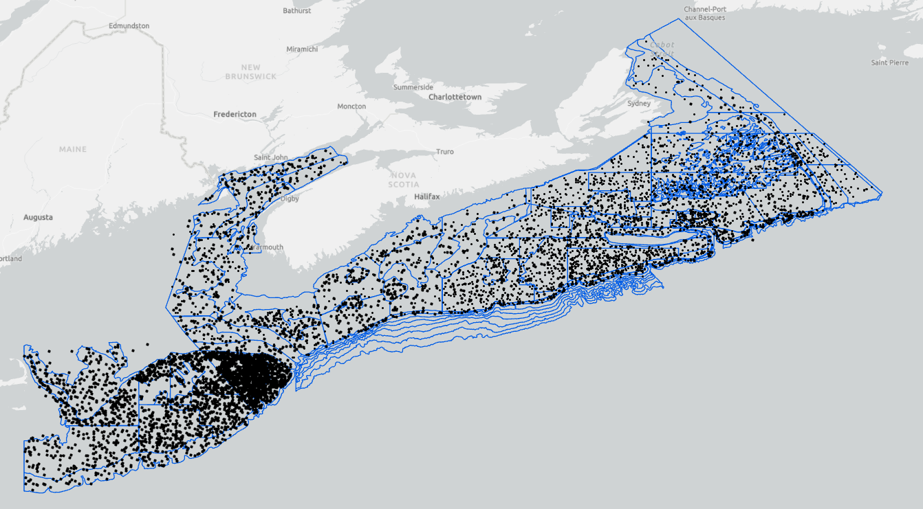
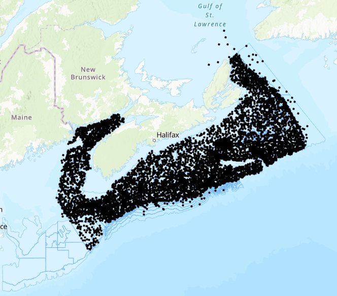
Gulf of Maine and Bay of Fundy
Type of resources
Topics
Keywords
Contact for the resource
Provided by
Formats
Representation types
Update frequencies
status
-

A coastal surficial substrate layer for the coastal Scotian Shelf and Bay of Fundy. To create the layer, previous geological characterizations from NRCan were translated into consistent substrate and habitat characterizations; including surficial grain size and primary habitat type. In areas where no geological description was available, data including digital elevation models and substrate samples from NRCan, CHS and DFO Science were interpreted to produce a regional scale substrate and habitat characterization. Each characterization in the layer was given a ranking of confidence and original data resolution to ensure that decision makers are informed of the quality and scale of data that went into each interpretation. Cite this data as: Greenlaw, M., Harvey, C. Data of: A substrate classification for the Inshore Scotian Shelf and Bay of Fundy, Maritimes Region. Published: March 2022. Coastal Ecosystems Science Division, Fisheries and Oceans Canada, St. Andrews, N.B. https://open.canada.ca/data/en/dataset/f2c493e4-ceaa-11eb-be59-1860247f53e3
-

PURPOSE: To provide a permanent repository of key data series necessary to build a range-wide American eel stock assessment. DESCRIPTION: This collection presents data associated with the following report: Cairns, D.K. 2020. Landings, abundance indicators, and biological data for a potential range-wide American eel stock assessment. Canadian Data Report of Fisheries and Aquatic Science. No. 1311: v + 180 pp. Much of the data collection is from the Atlantic Provinces of Canada, particularly the Southern Gulf of St. Lawrence. The collection also includes data from elsewhere in the American eel's range in Canada, and also the United States and the Caribbean Basin. Files in the collection are as follows. Cairns2020_AnnexA_ReportTables.xlsx: This Excel file (file size 756 kb) contains all 37 tables in Cairns (2020) exactly as they appear in the report. Cairns2020_AnnexB_EelLengthsAgesEfishingRecords.xlsx: This Excel file (file size 3.1 mb) contains 20,047 records of American eel lengths and other biological data from the Canadian Atlantic Provinces, 1983-2017. Records include weights of 8,915 eels and ages of 2,212 eels. Records of 3,224 electrofishing sessions in the Miramichi River, New Brunswick, 1952-2019, and records of 2,590 electrofishing sessions in the Restigouche River, New Brunswick, 1972-2019 are included. Cairns2020_AnnexC_EelLengthsAgesDataDefinitions.csv: This .csv file (file size 4 kb) gives data definitions in English and French for the table of eel lengths and other biological data that is contained in Cairns2020_AnnexB_EelLengthsAgesEfishingRecords.xlsx and in Cairns2020_AnnexD_EelLengthsAges.csv. Cairns2020_AnnexD_EelLengthsAges.csv: This file (file size 2.0 mb) presents in .csv format the table of eel lengths and other biological data that is also presented in Cairns2020_AnnexB_EelLengthsAgesEfishingRecords.xlsx. Cairns2020_AnnexE_EelEFishingDataDefinitions.csv: This .csv file (file size 2 kb) gives data definitions in English and French for the table of eel electrofishing data that is contained in Cairns2020_AnnexB_EelLengthsAgesEfishingRecords.xlsx and in Cairns2020_AnnexD_EelLengthsAges.csv. Cairns2020_AnnexF_EelEFishing.csv: This file (file size 314 kb) presents in .csv format the table of eel electrofishing data that is also presented in Cairns2020_AnnexB_EelLengthsAgesEfishingRecords.xlsx. Cairns2020_AnnexG_OtolithImageMetadata.csv: This .csv file (file size 2 kb) provides metadata for the collection of eel otolith images. Files with names starting with EelOtos . . . . : These .tif, .jpg, and .bmp image files are in zipped format with a summed size of 5.3 gb. The files give magnified photos of 1,838 eel otoliths that have been prepared for age reading. Samples are from the Atlantic Provinces of Canada. Individual otolith codes in Cairns2020_AnnexB_EelLengthsAgesEfishingRecords.xlsx and in Cairns2020_AnnexC_EelLengthsAgesDataDefinitions.csv match the codes embedded in otolith image filenames. PARAMETERS COLLECTED: American eel landings, number caught, and effort of commercial and research fishing gear. American eel lengths, ages, sex and other biological data and sampling locations. NOTES ON QUALITY CONTROL: All keypunched records of landings, densities, and other data were verified against original sources. Landings and abundance indices were reviewed in a Department of Fisheries and Oceans scientific workshop and corrected as necessary. Length and age data were examined by length-weight and length age plots and implausible records were discarded. PHYSICAL SAMPLE DETAILS: No physical samples SAMPLING METHODS: Landings are from government fisheries agencies. Abundance indices are from commercial fyke, spear, and trap catch per unit effort, and from research ladder counts and electrofishing records. Mean elver lengths are compiled from published literature Sex ratios are compiled from published literature Locations of biological and genetic sampling are compiled from published literature American eel lengths are total length of live specimens. Ages are from otolith annulus readings Electrofishing records are from backpack electrofishing surveys in wadeable waters USE LIMITATION: To ensure scientific integrity and appropriate use of the data, we would encourage you to contact the data custodian.
-

The lobster recruitment project is run by the Fishermen and Scientist Research Society (FSRS) through DFO funding. Fishermen participating in the lobster recruitment project collect information about lobster in their fishing area by fishing 2-5 scientific project traps (SPTs) (fished in fixed locations) within the regular commercial season. The SPTs used in all fishing areas are smaller than commercial traps and designed to primarily catch juvenile lobsters below the legal-size limit. These traps are additional to the vessel's legal number of commercial traps. The lobster recruitment project has more than 120 fishers participating from all LFAs along the Atlantic coast of Nova Scotia from LFA 27 in Cape Breton to LFA 35 in the Bay of Fundy (excluding LFA 28, who have not participated to-date). The number of fishermen per LFA and number of SPTs per fisherman are decided on by the LFA Advisory Committees. This decision considers how much additional effort they were comfortable having in the LFA (i.e. number of SPTs) and from how many traps each fisher could be reasonably expected to collect data. It is also important to have fishers dispersed enough to maximize study footprint. DFO Science consults on project design. SAMPLING METHODS: The fishers record the number, sex and length of lobsters captured in each SPT, as well as presence of eggs, tags or v-notch. Bottom temperatures are monitored by placing a temperature recorder in one of their SPTs for the entire lobster season. Cite this data as: Tibbets-Scott, S., Zisserson, B. Data of: Fishermen and Scientist Research Society (FSRS) Lobster Recruitment Trap Project. Published: November 2020. Population Ecology Division, Fisheries and Oceans Canada, Dartmouth, N.S. https://open.canada.ca/data/en/dataset/a88f9b4d-b59a-44f6-ae7e-d36550266940
-

“4VSW” missions focus on the eastern half of the Scotian Shelf, and occur primarily in March, but sets in both February, and April are also present in the data. These missions use a unique stratification scheme intended to optimize the abundance estimates of cod. Collected data includes total catch in numbers and weights by species. Length frequency data is available for most species, as are the age, sex, maturity and weight information for a subset of the individual animals. Other data such as ageing material, genetic material, and stomach contents are often also collected, but are stored elsewhere. Cite this data as: Clark, D., Emberley, J. Data of Maritimes 4VSW Research Vessel Survey. Published January 2021. Population Ecology Division, Fisheries and Oceans Canada, Dartmouth, N.S. https://open.canada.ca/data/en/dataset/a851ce30-e216-4d7d-a29c-05631eef140e
-
The Fisheries and Oceans Canada ecosystem surveys are conducted annually and are a source of integrated ecosystem monitoring data. These survey data are the primary data source for monitoring trends in species distribution, abundance, and biological condition within the region, and also provide data to the Atlantic Zonal Monitoring Program (AZMP) for monitoring hydrographic conditions, along with zooplankton and phytoplankton. The surveys follow a stratified random sampling design, and include sampling using a bottom otter trawl, CTD rosette and vertical plankton tows. Data from the bottom trawl catch are used to monitor the distribution and abundance of fish and invertebrates throughout the Scotian Shelf, Bay of Fundy and Georges Bank. Cite this data as: Clark, D., Emberley, J. Data of MARITIMES RESEARCH VESSEL SURVEYS. Published January 2021. Population Ecology Division, Fisheries and Oceans Canada, Dartmouth, N.S. https://open.canada.ca/data/en/dataset/8ddcaeea-b806-4958-a79f-ba9ab645f53b
-

The Fisheries and Oceans Canada (DFO) ecosystem surveys consist of research vessel survey data collected to monitor the distribution and abundance of fish and invertebrates throughout the Scotian Shelf, Bay of Fundy and Georges Bank. The surveys follow a stratified random sampling design, and include sampling of fish and invertebrates using a bottom otter trawl. These survey data are the primary data source for monitoring trends in species distribution, abundance, and biological condition within the region, and also provide data to the Atlantic Zonal Monitoring Program (AZMP) for monitoring hydrographic variability. Collected data includes total catch in numbers and weights by species. Length frequency data is available for most species, as are the age, sex, maturity and weight information for a subset of the individual animals. Other data such as ageing material, genetic material, and stomach contents are often also collected, but are stored elsewhere. “Spring” cruises occur in January, February, March and April, and focus on Georges Bank (i.e. 5Z). Cite this data as: Clark, D., Emberley, J. Data of MARITIMES SPRING RESEARCH VESSEL SURVEY. Published January 2021. Population Ecology Division, Fisheries and Oceans Canada, Dartmouth, N.S. https://open.canada.ca/data/en/dataset/fecf045a-95a2-4b69-8a40-818649a62716
-

"Fall" missions occur primarily in October and November, but sets from September and December are also present in the data. Collected data includes total catch in numbers and weights by species. Length frequency data is available for most species, as are the age, sex, maturity and weight information for a subset of the individual animals. Other data such as ageing material, genetic material, and stomach contents are often also collected, but are stored elsewhere. "Fall" cruises occur in September, October, November and December. Cite this data as: Clark, D., Emberley, J. Data of Maritimes Fall Research Vessel Survey. Published January 2021. Population Ecology Division, Fisheries and Oceans Canada, Dartmouth, N.S. https://open.canada.ca/data/en/dataset/5f82b379-c1e5-4a02-b825-f34fc645a529
-
“Summer” missions occur in June, July and August and these focus on the Scotian Shelf and Bay of Fundy (i.e. 4VWX 5Yb, expanding recently to include the Laurentian Channel and Georges Bank (5Zc). Collected data includes total catch in numbers and weights by species. Length frequency data is available for most species, as are the age, sex, maturity and weight information for a subset of the individual animals. Other data such as ageing material, genetic material, and stomach contents are often also collected, but are stored elsewhere. “Summer” cruises occur in May, June, July and August and these focus on the Scotian Shelf and Bay of Fundy (i.e. 4VWX). Cite this data as: Clark, D., Emberley, J. Data of MARITIMES SUMMER RESEARCH VESSEL SURVEYS. Published January 2021. Population Ecology Division, Fisheries and Oceans Canada, Dartmouth, N.S. https://open.canada.ca/data/en/dataset/1366e1f1-e2c8-4905-89ae-e10f1be0a164