 Arctic SDI catalogue
Nature and Biodiversity - Habitat
Type of resources
Available actions
Topics
Keywords
Contact for the resource
Provided by
Formats
Representation types
Update frequencies
status
-
These shorebird surveys are conducted intermittently at a series of sites near the town of Tofino on the west coast of Vancouver Island, British Columbia, during northward (April to May) and southward migration (July to November). This survey includes all shorebird species. Surveyors used binoculars or a spotting scope to count the total number of shorebirds present within the natural boundaries of each survey site during the northward and/or southward migration periods. They used a boat to count birds within the entire area of Arakun Flats and Ducking Flats by traveling along the outer edge of the mudflats, and by stopping at standardized vantage points on land. They also used a boat to view as much area as possible within Maltby Slough, South Bay and Grice Bay from the openings to each of these bays. Surveyors walked the entire length of Chesterman Beach including the tombolo to Frank Island. Surveys were done at least twice a week at each site. Most boat surveys began at low tide when the mudflats were exposed and continued on the rising tide. Road accessible sites were usually surveyed during the hour before high tide or at high tide in 2011. Surveys were not conducted in weather that reduced visibility or made boat travel unsafe (heavy rain or high wind). Surveyors counted birds individually when they were within flocks of fewer than 200 birds. They estimated the size of larger flocks by counting 50 or 100 birds and then judged how many similar-sized groups made up the entire flock. Distant flocks were recorded as small or large shorebirds and assumed to have the same species composition as those closer to shore in 1995 or identified to species group and recorded as either “dowitchers” or “peeps” in 2011.
-
Surveyor shorebird bird observations and counts for all years.
-
Eelgrass (Zostera marina) is important to waterfowl such as Atlantic Brant (Branta bernicla hrota), Canada Goose (Branta canadensis), American Black Duck (Anas rubripes), Common Goldeneye (Bucephala clangula) and Barrow's Goldeneye (Bucephala islandica). In New Brunswick eelgrass can be found along the Gulf of St. Lawrence, in protected harbours. Within this dataset are the results of eelgrass land-cover classifications using either satellite or aerial photography for seven harbours: Bouctouche (46 30’N, 64 39’W); Miscou (47.90 N, -64.55 W); Neguac (47.25 N, -65.03 W); Richibucto (46.70 N, -64.80 W); Saint-Simon (47.77 N, -64.76 W); Tracadie (47.55 N, -64.88 W); and Cocagne (46.370 N, -64.600 W). Information on each dataset is provided: 1. Bouctouche This dataset contains results from an eelgrass classification for Bouctouche Bay, New Brunswick. True colour aerial photography at 57 centimetre resolution was collected on September 2, 2009 by Nortek Resources of Thorburn, Nova Scotia (http://www.nortekresources.com/). Image classification was conducted using eCognition Developer v. 8 Software, which first segments the image into spectrally similar units, which were then classified manually. Additionally, the Department of Fisheries and Oceans (Gulf Region, Moncton, NB) conducted a visual field survey in the same field season at 688 sites. Two-thirds of these sites were used to assist in image classification, while the remainder were used to assess accuracy. Three classes were identified: i. Good Quality Eelgrass: relatively dense, clean, green blades with minimal epiphytes or algal growth. ii. Medium Quality Eelgrass: predominately green blades that may have some epiphyte or algal growth. These stands can be less or equally dense as Good Quality Eelgrass, but the best grasses are certainly not as abundant. iii. Eelgrass Absent/Poor Quality: eelgrass is absent, or if it is present it is typically covered with epiphytes or other algae or dying or dead. Eelgrass was classified correctly 83.7% of the time in a fuzzy accuracy assessment technique, whereby those classes that were ‘off’ by one class, e.g. Good Quality eelgrass classed as Medium Quality, were given half credit towards the overall accuracy. Of 187 sites that were within the classification area, 131 were correct, 51 were "one-off", and 5 were incorrect [(131 + (51/2))/ 187 = 0.837]. 2. Miscou True colour aerial photography at 57 centimetre resolution was collected on August 20th and 24th, 2009 by Nortek Resources of Thorburn, Nova Scotia (http://www.nortekresources.com/). Image classification was conducted using eCognition Developer v. 8 Software, which first segments the image into spectrally similar units, which were then classified manually. Additionally, the Department of Fisheries and Oceans (Gulf Region, Moncton, NB) conducted a visual field survey in the same field season at 103 sites. From these sites 70% were used to assist in image classification, while the remainder were used to assess accuracy. Three classes were identified: i. Good Quality Eelgrass: relatively dense, clean, green blades with minimal epiphytes or algal growth. ii. Medium Quality Eelgrass: predominately green blades that may have some epiphyte or algal growth. These stands can be less or equally dense as Good Quality Eelgrass, but the best grasses are certainly not as abundant. iii. Eelgrass Absent/Poor Quality: eelgrass is absent, or if it is present it is typically covered with epiphytes or other algae or dying or dead. Eelgrass was classified correctly 96.7% of the time (30/31 = 0.967). 3. Neguac This dataset contains results from an eelgrass classification for Neguac Bay, New Brunswick. True colour aerial photography at 57 centimetre resolution was collected on September 2, 2009 by Nortek Resources of Thorburn, Nova Scotia (http://www.nortekresources.com/). Image classification was conducted using eCognition Developer v. 8 Software, which first segments the image into spectrally similar units, which were then classified manually. Additionally, the Department of Fisheries and Oceans (Gulf Region, Moncton, NB) conducted a visual field survey in the same field season at 126 sites. Two-thirds of these sites were used to assist in image classification, while the remainder were used to assess accuracy. Three classes were identified: i. Good Quality Eelgrass: relatively dense, clean, green blades with minimal epiphytes or algal growth. ii. Medium Quality Eelgrass: predominately green blades that may have some epiphyte or algal growth. These stands can be less or equally dense as Good Quality Eelgrass, but the best grasses are certainly not as abundant. iii. Eelgrass Absent/Poor Quality: eelgrass is absent, or if it is present it is typically covered with epiphytes or other algae or dying or dead. Eelgrass was classified correctly 81% of the time in a fuzzy accuracy assessment technique, whereby those classes that were ‘off’ by one class, e.g. Good Quality eelgrass classed as Medium Quality, were given half credit towards the overall accuracy. Of 39 sites that were within the classification area, 27 were correct, 9 were "one-off", and 3 were incorrect [(27 + (9/2))/ 39 = 0.81]. 4. Richibucto Eelgrass classification in Richibucto Harbour, New Brunswick. Derived from a Quickbird satellite image collected on August 28, 2007 at as close to low-tide as possible. Quickbird's ground resolution is 2.4 m. Classification was objected-oriented using Definiens software. Accuracy was 81.5%. Data used for accuracy and training was collected along transects using a differential GPS positioned towfish holding sidescan sonar, and a video camera that was later transcribed as XY points to describe eel-grass presence. 5. Saint-Simon An eelgrass distribution map was classified from remotely sensed imagery in Shippagan Harbour, New Brunswick. Derived from a Quickbird satellite image collected on July 27, 2007 at as close to low-tide as possible. Classification was objected-oriented using Definiens software. Data used for accuracy and training was collected along transects using a differential GPS positioned towfish holding sidescan sonar, and a video camera that was later transcribed as XY points to describe eel-grass presence. 6. Tracadie This dataset contains results from an eelgrass classification for Tracadie Bay, New Brunswick. True colour aerial photography at 57 centimetre resolution was collected on September 2, 2009 by Nortek Resources of Thorburn, Nova Scotia (http://www.nortekresources.com/). Image classification was conducted using eCognition Developer v. 8 Software, which first segments the image into spectrally similar units, which were then classified manually. Additionally, the Department of Fisheries and Oceans (Gulf Region, Moncton, NB) conducted a visual field survey in the same field season at 101 sites. Approximately two-thirds of these sites were used to assist in image classification, while the remainder was used to assess accuracy. Three classes were identified: i. Good Quality Eelgrass: relatively dense, clean, green blades with minimal epiphytes or algal growth. ii. Medium Quality Eelgrass: predominately green blades that may have some epiphyte or algal growth. These stands can be less or equally dense as Good Quality Eelgrass, but the best grasses are certainly not as abundant. iii. Eelgrass Absent/Poor Quality: eelgrass is absent, or if it is present it is typically covered with epiphytes or other algae or dying or dead. Eelgrass was classified correctly 79.3% of the time in a fuzzy accuracy assessment technique, whereby those classes that were ‘off’ by one class, e.g. Good Quality eelgrass classed as Medium Quality, were given half credit towards the overall accuracy. Of 29 sites that were within the classification area, 18 were correct, 10 were "one-off", and 1 was incorrect [(18 + (10/2))/ 29 = 0.793]. 7. Cocagne Visible orthorectified aerial photography was used to classify polygons containing eelgrass in Cocagne Harbour. Field data for image training and validation were collected along transects in summer 2008 using a dGPS positioned towfish holding sidescan sonar and a video camera that was later transcribed as XY geographic points to describe eelgrass presence and a qualitative description of density. The area was flown for photography on September 24, 2008. eCognition Developer 8 software was used to segment the imagery, essentially polygons. Polygons were then classified manually for the presence of eelgrass. Using field data revealed eelgrass presence to be mapped correctly 87.2% of the time.
-

This spatial file includes the polygon boundaries of the four Pacific Great Blue Heron Conservation Regions in British Columbia, as described in the management plan. These Conservation Regions are recognized based on degree of isolation, population sizes, and differences in trends and threats. The management objective for Pacific Great Blue Heron is to ensure that all four Conservation Regions have stable or locally increasing numbers of herons. Refer to the "Management Plan for the Great Blue Heron fannini subspecies (Ardea herodias fannini) in Canada" on the SARA Regristry for more information.
-
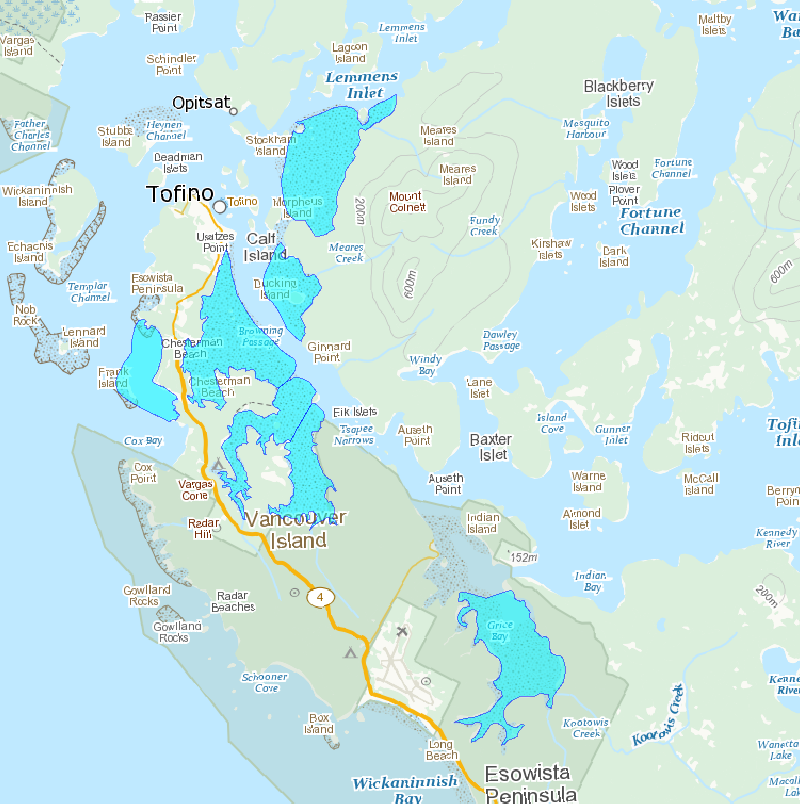
Survey areas is a polygon feature class containing mudflats and staging areas observed for shorebirds.
-
Eelgrass (Zostera marina) is important to waterfowl such as Atlantic Brant (Branta bernicla hrota), Canada Goose (Branta canadensis), American Black Duck (Anas rubripes), Common Goldeneye (Bucephala clangula) and Barrow's Goldeneye (Bucephala islandica). In New Brunswick eelgrass can be found along the Gulf of St. Lawrence, in protected harbours. Within this dataset are the results eelgrass land-cover classifications using either satellite or aerial photography for eight harbours: Bouctouche (46 30’N, 64 39’W); Cocagne (46.37 N, -64.60 W); Miscou (47.90 N, -64.55 W); Neguac (47.25 N, -65.03 W); Richibucto (46.70 N, -64.80 W); Saint-Simon (47.77 N, -64.76 W); Tabusintac (47.33 N, -64.93 W); and Tracadie (47.55 N, -64.88 W). Information on each dataset is provided: Visible orthorectified aerial photography was used to classify polygons containing eelgrass in Cocagne Harbour. Field data for image training and validation were collected along transects in summer 2008 using a dGPS positioned towfish holding sidescan sonar and a video camera that was later transcribed as XY geographic points to describe eelgrass presence and a qualitative description of density. The area was flown for photography on September 24, 2008. eCognition Developer 8 software was used to segment the imagery, essentially polygons. Polygons were then classified manually for the presence of eelgrass. Using field data revealed eelgrass presence to be mapped correctly 87.2% of the time.
-

Survey transects is a line feature class containing transects completed in 2011.
-

This file includes the spatial boundaries for the Pacific Great Blue Heron Potential Area of Occupancy for its entire Canadian range. The Potential Area of Occupancy is a simple model that highlights the heron's preferred forest habitat at a high level. Potential Area of Occupancy is defined as terrestrial areas within the Coastal Douglas Fir and Coastal Western Hemlock Biogeoclimatic zones that are less than 10 km from a potential foraging area and west of the Cascades mountain range. Potential foraging areas are defined as the entire coastline and major river systems less than 1000 m in elevation. Refer to the "Management Plan for the Great Blue Heron fannini subspecies (Ardea herodias fannini) in Canada" on the SARA Regristry for more information.
-
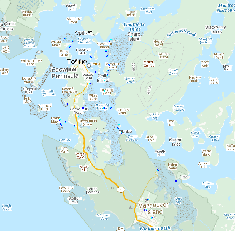
Survey points is a point feature class containing transects and observations completed in 2011.
-

This dataset displays the geographic areas within which critical habitat (CH) for terrestrial species at risk, listed on Schedule 1 of the federal Species at Risk Act (SARA), occurs in Canada. Note that this includes only terrestrial species and species for which Environment and Climate Change Canada (ECCC) and Parks Canada Agency (PCA) lead. Under SARA, critical habitat is “the habitat that is necessary for the survival or recovery of a listed wildlife species and that is identified as the species’ critical habitat in the recovery strategy or action plan for the species.” To precisely define what constitutes critical habitat for a particular species it is essential that this geospatial information be considered in conjunction with complementary information provided in a species’ recovery document. Recovery documents are available from the Species at Risk (SAR) Public Registry (https://www.canada.ca/en/environment-climate-change/services/species-risk-public-registry.html) for two posting stages (proposed and final posting). The recovery documents contain important information about the interpretation of the geospatial information, especially regarding the biological and environmental features (“biophysical attributes”) that complete the definition of a species’ critical habitat. Within any defined critical habitat geospatial boundary, not all of the area is necessarily critical habitat. It is important to note that recovery planning documents (and, therefore, critical habitat) may be amended from time to time as new information becomes available, which may occur after a document has been posted as proposed or final on the SAR Public Registry. The SAR Public Registry should always be considered as the main source for critical habitat information. In cases where the data are sensitive, the geographic area within which critical habitat occurs may be represented as grids. These are coarse grids (1, 10, 50 or 100 square kilometres) that serve as indicators to locate critical habitat in the recovery planning document. More detailed information on critical habitat may be made available on a need-to-know basis by contacting Environment and Climate Change Canada – Canadian Wildlife Service at ec.planificationduretablissement-recoveryplanning.ec@canada.ca. The data is current as of the date of the most recent revision.