 Arctic SDI catalogue
Strait of Georgia
Type of resources
Topics
Keywords
Contact for the resource
Provided by
Formats
Representation types
Update frequencies
status
-
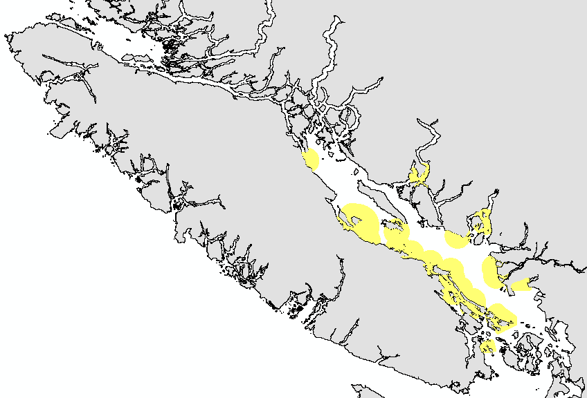
This layer details Important Areas (IAs) relevant to key vertebrate species, other than fish and cetaceans, in the Strait of Georgia (SOG) ecoregion. This data was mapped to inform the selection of marine Ecologically and Biologically Significant Areas (EBSA). Experts have indicated that these areas are relevant based upon their high ranking in one or more of three criteria (Uniqueness, Aggregation, and Fitness Consequences). The distribution of IAs within ecoregions is used in the designation of EBSAs. Canada’s Oceans Act provides the legislative framework for an integrated ecosystem approach to management in Canadian oceans, particularly in areas considered ecologically or biologically significant. DFO has developed general guidance for the identification of ecologically or biologically significant areas. The criteria for defining such areas include uniqueness, aggregation, fitness consequences, resilience, and naturalness. This science advisory process identifies proposed EBSAs in Canadian Pacific marine waters, specifically in the Strait of Georgia (SOG), along the west coast of Vancouver Island (WCVI, southern shelf ecoregion), and in the Pacific North Coast Integrated Management Area (PNCIMA, northern shelf ecoregion). Initial assessment of IA's in PNCIMA was carried out in September 2004 to March 2005 with spatial data collection coordinated by Cathryn Clarke. Subsequent efforts in WCVI and SOG were conducted in 2009, and may have used different scientific advisors, temporal extents, data, and assessment methods. WCVI and SOG IA assessment in some cases revisits data collected for PNCIMA, but should be treated as a separate effort. Other datasets in this series detail IAs for birds, cetaceans, corals and sponges, fish, geographic features, and invertebrates. Though data collection is considered complete, the emergence of significant new data may merit revisiting of IA's on a case by case basis.
-

Zooplankton data collected during surveys conducted in the central and northern Strait of Georgia, 1996-2018.
-

This layer details Important Areas (IAs) relevant to important geographic features in the Strait of Georgia (SOG) ecoregion. This data was mapped to inform the selection of marine Ecologically and Biologically Significant Areas (EBSA). Experts have indicated that these areas are relevant based upon their high ranking in one or more of three criteria (Uniqueness, Aggregation, and Fitness Consequences). The distribution of IAs within ecoregions is used in the designation of EBSAs. Canada’s Oceans Act provides the legislative framework for an integrated ecosystem approach to management in Canadian oceans, particularly in areas considered ecologically or biologically significant. DFO has developed general guidance for the identification of ecologically or biologically significant areas. The criteria for defining such areas include uniqueness, aggregation, fitness consequences, resilience, and naturalness. This science advisory process identifies proposed EBSAs in Canadian Pacific marine waters, specifically in the Strait of Georgia (SOG), along the west coast of Vancouver Island (WCVI, southern shelf ecoregion), and in the Pacific North Coast Integrated Management Area (PNCIMA, northern shelf ecoregion). Initial assessment of IAs in PNCIMA was carried out in September 2004 to March 2005 with spatial data collection coordinated by Cathryn Clarke. Subsequent efforts in WCVI and SOG were conducted in 2009, and may have used different scientific advisors, temporal extents, data, and assessment methods. WCVI and SOG IA assessment in some cases revisits data collected for PNCIMA, but should be treated as a separate effort. Other datasets in this series detail IAs for birds, cetaceans, coral and sponges, fish, invertebrates, and other vertebrates. Though data collection is considered complete, the emergence of significant new data may merit revisiting of IAs on a case by case basis.
-

This layer details Important Areas (IAs) relevant to key seabird species in the Strait of Georgia (SOG) ecoregion. This data was mapped to inform the selection of marine Ecologically and Biologically Significant Areas (EBSA). Experts have indicated that these areas are relevant based upon their high ranking in one or more of three criteria (Uniqueness, Aggregation, and Fitness Consequences). The distribution of IAs within ecoregions is used in the designation of EBSAs. Canada’s Oceans Act provides the legislative framework for an integrated ecosystem approach to management in Canadian oceans, particularly in areas considered ecologically or biologically significant. DFO has developed general guidance for the identification of ecologically or biologically significant areas. The criteria for defining such areas include uniqueness, aggregation, fitness consequences, resilience, and naturalness. This science advisory process identifies proposed EBSAs in Canadian Pacific marine waters, specifically in the Strait of Georgia (SOG), along the west coast of Vancouver Island (WCVI, southern shelf ecoregion), and in the Pacific North Coast Integrated Management Area (PNCIMA, northern shelf ecoregion). Initial assessment of IAs in PNCIMA was carried out in September 2004 to March 2005 with spatial data collection coordinated by Cathryn Clarke. Subsequent efforts in WCVI and SOG were conducted in 2009, and may have used different scientific advisors, temporal extents, data, and assessment methods. WCVI and SOG IA assessment in some cases revisits data collected for PNCIMA, but should be treated as a separate effort. Other datasets in this series detail IAs for cetaceans, coral and sponges, fish, geographic features, invertebrates, and other vertebrates. Though data collection is considered complete, the emergence of significant new data may merit revisiting of IAs on a case by case basis.
-

This layer details Important Areas (IAs) relevant to key cetacean species in the Strait of Georgia (SOG) ecoregion. This data was mapped to inform the selection of marine Ecologically and Biologically Significant Areas (EBSA). Experts have indicated that these areas are relevant based upon their high ranking in one or more of three criteria (Uniqueness, Aggregation, and Fitness Consequences). The distribution of IA's within ecoregions is used in the designation of EBSA's. Canada’s Oceans Act provides the legislative framework for an integrated ecosystem approach to management in Canadian oceans, particularly in areas considered ecologically or biologically significant. DFO has developed general guidance for the identification of ecologically or biologically significant areas. The criteria for defining such areas include uniqueness, aggregation, fitness consequences, resilience, and naturalness. This science advisory process identifies proposed EBSAs in Canadian Pacific marine waters, specifically in the Strait of Georgia (SOG), along the west coast of Vancouver Island (WCVI, southern shelf ecoregion), and in the Pacific North Coast Integrated Management Area (PNCIMA, northern shelf ecoregion). Initial assessment of IA's in PNCIMA was carried out in September 2004 to March 2005 with spatial data collection coordinated by Cathryn Clarke. Subsequent efforts in WCVI and SOG were conducted in 2009, and may have used different scientific advisors, temporal extents, data, and assessment methods. WCVI and SOG IA assessment in some cases revisits data collected for PNCIMA, but should be treated as a separate effort. Other datasets in this series detail IAs for birds, coral and sponges, fish, geographic features, invertebrates, and other vertebrates. Though data collection is considered complete, the emergence of significant new data may merit revisiting of IA's on a case by case basis.
-
This layer details Important Areas (IAs) relevant to sponge reefs (Hexactinosida) in the Strait of Georgia (SOG) ecoregion. This data was mapped to inform the selection of marine Ecologically and Biologically Significant Areas (EBSA). Experts have indicated that these areas are relevant based upon their high ranking in one or more of three criteria (Uniqueness, Aggregation, and Fitness Consequences). The distribution of IAs within ecoregions is used in the designation of EBSAs. Canada’s Oceans Act provides the legislative framework for an integrated ecosystem approach to management in Canadian oceans, particularly in areas considered ecologically or biologically significant. DFO has developed general guidance for the identification of ecologically or biologically significant areas. The criteria for defining such areas include uniqueness, aggregation, fitness consequences, resilience, and naturalness. This science advisory process identifies proposed EBSAs in Canadian Pacific marine waters, specifically in the Strait of Georgia (SOG), along the west coast of Vancouver Island (WCVI, southern shelf ecoregion), and in the Pacific North Coast Integrated Management Area (PNCIMA, northern shelf ecoregion). Initial assessment of IA's in PNCIMA was carried out in September 2004 to March 2005 with spatial data collection coordinated by Cathryn Clarke. Subsequent efforts in WCVI and SOG were conducted in 2009, and may have used different scientific advisors, temporal extents, data, and assessment methods. WCVI and SOG IA assessment in some cases revisits data collected for PNCIMA, but should be treated as a separate effort. Other datasets in this series detail IAs for birds, cetaceans, fish, geographic features, invertebrates, and other vertebrates. Though data collection is considered complete, the emergence of significant new data may merit revisiting of IA's on a case by case basis.
-

This layer details Important Areas (IAs) relevant to key fish species in the Strait of Georgia (SOG) ecoregion. This data was mapped to inform the selection of marine Ecologically and Biologically Significant Areas (EBSA). Experts have indicated that these areas are relevant based upon their high ranking in one or more of three criteria (Uniqueness, Aggregation, and Fitness Consequences). The distribution of IAs within ecoregions is used in the designation of EBSAs. Canada’s Oceans Act provides the legislative framework for an integrated ecosystem approach to management in Canadian oceans, particularly in areas considered ecologically or biologically significant. DFO has developed general guidance for the identification of ecologically or biologically significant areas. The criteria for defining such areas include uniqueness, aggregation, fitness consequences, resilience, and naturalness. This science advisory process identifies proposed EBSAs in Canadian Pacific marine waters, specifically in the Strait of Georgia (SOG), along the west coast of Vancouver Island (WCVI, southern shelf ecoregion), and in the Pacific North Coast Integrated Management Area (PNCIMA, northern shelf ecoregion). Initial assessment of IAs in PNCIMA was carried out in September 2004 to March 2005 with spatial data collection coordinated by Cathryn Clarke. Subsequent efforts in WCVI and SOG were conducted in 2009, and may have used different scientific advisors, temporal extents, data, and assessment methods. WCVI and SOG IA assessment in some cases revisits data collected for PNCIMA, but should be treated as a separate effort. Other datasets in this series detail IAs for birds, cetaceans, coral and sponges, geographic features, invertebrates, and other vertebrates. Though data collection is considered complete, the emergence of significant new data may merit revisiting of IAs on a case by case basis.
-

Harbour seals (Phoca vitulina) are found along temperate and Arctic marine coastlines of the Northern Hemisphere. They are found in coastal waters of the northern Atlantic and Pacific Oceans, as well as those of the Baltic and North Seas. In Canada, they may be found off the coastal waters of British Columbia, Nunavut, Manitoba, Ontario, Quebec, New Brunswick, Prince Edward Island, Nova Scotia, and Newfoundland and Labrador. Population trends and abundance of harbour seals in British Columbia are assessed based on aerial surveys conducted during 1966-2019. Based on counts conducted in Index Areas distributed throughout the province, the trend observed in the Strait of Georgia appears to be generally indicative of harbour seal populations throughout British Columbia. Total abundance of harbour seals on the B.C. coast in 2008 was estimated to be on the order of about 105,000 (95% confidence interval of 90,900 to 118,900) seals. Total abundance was re-estimated in 2022 (estimate and CI pending completion of CSAS process). Historic reconstructions indicate the population was depleted by a period of commercial harvesting during 1879-1914, and subsequently maintained below natural levels by predator control programs until the early 1960s. Already depleted, the population could not sustain a second period of intense commercial harvesting during 1962-1968 and was further depleted, but now appears to have fully recovered.
-

Fisheries and Oceans Canada (DFO) has been conducting surface water trawl surveys since 1992 in the coastal waters of British Columbia, Washington, Oregon and Alaska and in the high seas of the Gulf of Alaska. These surveys initially focused on determining the migratory patterns (1992-2002) and on the growth and physiology (2003-2016) of juvenile Pacific Salmon. Since 2016, these surveys have been broadened to monitor the whole pelagic ecosystem, retaining a focus on juvenile Pacific Salmon. Data were collected from sites in the inland sea waters of British Columbia and Washington State, USA, that comprise the Strait of Georgia, Strait of Juan de Fuca and Puget Sound since 2001 and are ongoing.
-

Catch, effort, location (latitude, longitude), relative abundance indices, and associated biological data from groundfish multi-species bottom trawl surveys in Strait of Georgia. Introduction The Strait of Georgia (SOG) synoptic bottom trawl survey was conducted in 2012 and 2015. This survey is one of a set of long-term and coordinated surveys that together cover the continental shelf and upper slope of most of the British Columbia coast. The other surveys are the Queen Charlotte Sound (QCS) survey, the Hecate Strait (HS) survey, the West Coast Vancouver Island (WCVI) survey and the West Coast Haida Gwaii (WCHG) survey. The survey was not impacted by the COVID-19 pandemic. The objectives of these surveys are to provide fishery independent abundance indices of all demersal fish species available to bottom trawling and to collect biological samples of selected species. The surveys follow a random depth-stratified design and the sampling units are 2 km by 2 km blocks. The synoptic bottom trawl surveys are conducted by Fisheries and Oceans Canada (DFO) in collaboration with the Canadian Groundfish Research and Conservation Society (CGRCS), a non-profit society composed of participants in the British Columbia commercial groundfish trawl fishery. The Queen Charlotte Sound and West Coast Haida Gwaii surveys are conducted under collaborative agreements, with the CGRCS providing chartered commercial fishing vessels and field technicians, while DFO provides in-kind contributions for running the surveys including personnel and equipment. The Hecate Strait, West Coast Vancouver Island, and Strait of Georgia surveys are conducted by DFO and have typically taken place on a Canadian Coast Guard research vessel. Until 2016 this vessel was the CCGS W.E. Ricker. From 2021 onwards, this vessel was the CCGS Sir John Franklin. In years when a coast guard vessel has not been available, the Hecate Strait, West Coast Vancouver Island, and Strait of Georgia surveys have taken place on chartered industry vessels. Data from these surveys are also presented in the groundfish data synopsis report (Anderson et al. 2019). Effort This table contains information about the survey trips and fishing events (trawl tows/sets) that are part of this survey series. Trip-level information includes the year the survey took place, a unique trip identifier, the vessel that conducted the survey, and the trip start and end dates (the dates the vessel was away from the dock conducting the survey). Set-level information includes the date, time, location, and depth that fishing took place, as well as information that can be used to calculate fishing effort (duration) and swept area. All successful fishing events are included, regardless of what was caught. Catch This table contains the catch information from successful fishing events. Catches are identified to species or to the lowest taxonomic level possible. Most catches are weighed, but some are too small (“trace” amounts) or too large (e.g. very large Big Skate). The unique trip identifier and set number are included so that catches can be related to the fishing event information (including capture location). Biology This table contains the available biological data for catches which were sampled. Data may include any or all of length, sex, weight, age. Different length types are measured depending on the species. Age structures are collected when possible for species where validated aging methods exist and are archived until required for an assessment; therefore, all existing structures have not been aged at this time. The unique trip identifier and set number are included so that samples can be related to the fishing event and catch information. Biomass This table contains relative biomass indices of species that have been captured in every survey of the time series. The coefficient of variation and bootstrapped 95% confidence intervals are provided for each index. The groundfish data synopsis report (Anderson et al. 2019) provides an explanation of how the relative biomass indices are derived.