 Arctic SDI catalogue
Wildlife
Type of resources
Available actions
Topics
Keywords
Contact for the resource
Provided by
Years
Formats
Representation types
Update frequencies
status
Service types
-
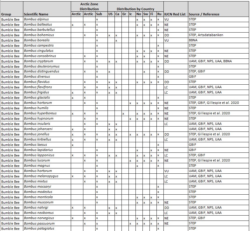
Known species from the High Arctic, Low Arctic, and Sub-Arctic, based on records from 1990 to 2022. Additional unknown species are likely present. Geographical Distribution Includes Arctic regions of eight political jurisdictions. Associated article is published in the 2022 Arctic Report Card essay entitled Arctic Pollinators by Burns et al.
-
Saskatchewan Environment Compliance and Field Services (CFS) Areas are administrative field office areas for managing and protecting our environment and making sure natural resources (i.e. fish and wildlife) are used wisely. The compliance areas are an aggrigation of the compliance field areas. The compliance field area boundaries are intended to topologically match the linework of the enforcement grid (not published). This grid is based on SG township boundaries in the south and national topographic system (NTS) 1:50,000 mapsheet extents in the north. It is important to note that although the term "Region" is used in this dataset, it is an older term that Compliance and Field Services Branch no longer uses. The Ministry of Environment no longer divides the province into regions. Use the terms "Compliance Areas" and "Compliance Field Areas" instead.
-
Saskatchewan Environment Compliance and Field Services (CFS) Areas are administrative field office areas for managing and protecting our environment and making sure natural resources (i.e. fish and wildlife) are used wisely. The compliance areas are an aggrigation of the compliance field areas. The compliance field area boundaries are intended to topologically match the linework of the enforcement grid (not published). This grid is based on SG township boundaries in the south and national topographic system (NTS) 1:50,000 mapsheet extents in the north. It is important to note that although the term "Region" is used in this dataset, it is an older term that Compliance and Field Services Branch no longer uses. The Ministry of Environment no longer divides the province into regions. Use the terms "Compliance Areas" and "Compliance Field Areas" instead.
-

TA_WILDLIFE_MGMT_AREAS_SVW contains the spatial representation (polygon) of the areas under the administration and control of the Conservation Lands Program of the Ministry of Forests, Lands, Natural Resource Operations and Rural Development and designated as Wildlife Management Areas under the Wildlife Act due to the significance of their wildlife/fish values. The view was created to provide a simplified view of this data from the administrative boundaries information in the Tantalis operational system
-
This boundary layer shows all Special Conservation Areas (SCA) in Manitoba. The purpose of this dataset is to show the boundaries of all Special Conservation Areas (SCA) in Manitoba, as designated by the Designation of Wildlife Lands Regulation (171/2001) under The Wildlife Act (C.C.S.M. c. W130). Special Conservation Areas are designated to conserve and protect particular species and habitats throughout Manitoba. The Use of Wildlife Lands Regulation (77/99) determines what activities are prohibited within each Special Conservation Area. Boundaries are drawn based on CAD files from the official Director of Surveys Plan stated in the regulation.Fields included (Alias (Field Name): Field description.)FID (FID): Sequential unique whole numbers that are automatically generatedName (NAME): Special Conservation Area nameD of S Plan (DofS): Director of Surveys plan numberArea_HA (AREA_HA): Area in HectaresSpecies (SPECIES): Species name
-
An interactive web application illustrating the locations of commercial fisheries, commercial fish species production (kg) for the 2016 calendar year. This interactive web application shows the locations of commercial fisheries and commercial fish species production (kg) in Manitoba, by community. It names the communities involved in the industry, shows the number of fishers by community and also shows the location of packing sheds across Manitoba. For each location, pop ups provides additional information, including the round weight (kg) by species for the 2016 calendar year. This application is populated by the web map: Manitoba Commercial Fishing Industry Map.
-
Game Hunting Areas (GHAs) are defined under the Hunting Areas and Zones Regulation (220/86) of The Wildlife Act (CCSM c. W130). Game Hunting Areas (GHAs) are defined under the Hunting Areas and Zones Regulation (220/86) of The Wildlife Act (CCSM c. W130). Game Hunting Areas are used to support boundaries for species specific hunting seasons, harvest allocations, bag limits, and associated regulations. Refer to the Hunting Areas and Zones Regulation for GHA boundary descriptions.
-
Feature layer of Fish Shed locations (Fish Packing Stations) across Manitoba. This feature layer - which is used in the Manitoba Commercial Fishing Industry Map and the Manitoba Commercial Fishing Industry Application - shows the Fish Shed locations (Fish Packing Stations) across Manitoba. This is a point layer that includes the name of the Fish Shed.
-
Since they are essential environments for wildlife, eleven categories of habitats benefit from legal protection in Quebec. Together, they protect a great diversity of wildlife species, including fish, crustaceans, molluscs, certain large mammals, such as caribou and deer, as well as numerous species of seabirds and waterfowl. Among the protected habitats, there are also those of endangered or vulnerable wildlife species. ### #LOI AND REGULATIONS * Wildlife Conservation and Development Act * Wildlife Habitat Regulation * Regulation on threatened or vulnerable wildlife species and their habitats ### #LISTE LEGALLY PROTECTED WILDLIFE HABITATS * Area of concentration of waterbirds * Caribou calving area north of the 52nd parallel * Caribou use area south of the 52nd parallel * White-tailed deer containment area * Cliff inhabited by a bird colony * Island or peninsula inhabited by a bird colony * Habitat of a threatened or vulnerable wildlife species * Heron (including the nest and the 0-200 m and 200-500 m bands that surround it) * Fish habitat * Muskrat habitat * Mudflat A shape file exists for all wildlife habitats in the province of Quebec. Wildlife habitats located on mixed and private lands are also found for information purposes. ### #SOURCES CARTOGRAPHIC Wildlife habitats are digitized using as a reference, in particular: * Quebec topographic database (BDTQ); * Domain layer of the Ministry of Natural Resources and Forests (MRNF); * Administrative divisions of Quebec on a scale of 1/20,000; * Digital imagery. References may vary depending on the case. Other sources can also be used ### #MISE DATA UPDATE The updating of wildlife habitat data follows a variable planning according to the habitat category and according to the inventories carried out and the needs of regional and central departments. ### #Mise on guard: The digital version of geo-descriptive data describing wildlife habitats is produced from a legal perspective of location, protection and management of habitats. In fact, only the digital version that has been published in the Official Gazette of Quebec is recognized as legal.**This third party metadata element was translated using an automated translation tool (Amazon Translate).**