 Arctic SDI catalogue
bridge
Type of resources
Available actions
Topics
Keywords
Contact for the resource
Provided by
Years
Formats
Representation types
Update frequencies
status
Resolution
-

Part of the Nova Scotia Topographic Database (NSTDB), the roads and railroads theme layer is updated and maintained from aerial photography and collected in the field with mobile GPS, Field inspections verify road way types such as surface and number of lanes. Road feature codes and their descriptions are provided with the download in a NSTDB feature code table. Data download also available via GeoNova: https://nsgi.novascotia.ca/WSF_DDS/DDS.svc/DownloadFile?tkey=fhrTtdnDvfytwLz6&id=15 Map service view also available via GeoNova: https://nsgiwa.novascotia.ca/arcgis/rest/services/BASE/BASE_NSTDB_10k_Roads_UT83/MapServer?f=jsapi
-

1:50,000 Cultural Line Features. Based on Edition 2.x. Distributed from [GeoYukon](https://yukon.ca/geoyukon) by the [Government of Yukon](https://yukon.ca/maps) . Discover more digital map data and interactive maps from Yukon's digital map data collection. For more information: [geomatics.help@yukon.ca](mailto:geomatics.help@yukon.ca)
-
Part of the Nova Scotia Topographic Database (NSTDB), the roads and railroads theme layer is updated and maintained from aerial photography and collected in the field with mobile GPS, Field inspections verify road way types such as surface and number of lanes. Road feature codes and their descriptions are provided with the download in a NSTDB feature code table. Data download also available via GeoNova: https://nsgi.novascotia.ca/WSF_DDS/DDS.svc/DownloadFile?tkey=fhrTtdnDvfytwLz6&id=15 Map service view also available via GeoNova: https://nsgiwa.novascotia.ca/arcgis/rest/services/BASE/BASE_NSTDB_10k_Roads_UT83/MapServer?f=jsapi
-
Yukon Bedrock Geology MapThis update of the Yukon bedrock geology map builds upon the previous compilation by Gordey and Makepeace (1999, 2001). It includes new, detailed bedrock geology maps and regional compilations that have been published by the Yukon Geological Survey and the Geological Survey of Canada between 1999 and 2015, as well as some recent thesis works. A few of these maps were partially integrated into the digital dataset by Gordey and Makepeace (2003), but only as overlay to the 1999 compilation. A number of errors and omissions from the 1999 compilation of Gordey and Makepeace were also noted and corrected during compilation of this version of the map. The Yukon bedrock geology GIS dataset is regularly updated and can be downloaded from the Yukon Geological Survey's website: www.geology.gov.yk.ca. Users are advised to consult the website regularly to ensure they are working with the latest version of the geodatabase or shape files. This update of the GIS dataset includes an expanded attribute structure (compared to the 1999 dataset) that facilitates searching of the geodatabase. The Yukon Geological Survey aims to provide users with the best available geoscience data for Yukon. Any revisions or additional geological information known to the user would be welcomed by the Yukon Geological Survey. Distributed from [GeoYukon](https://yukon.ca/geoyukon) by the [Government of Yukon](https://yukon.ca/maps) . Discover more digital map data and interactive maps from Yukon's digital map data collection. For more information: [geomatics.help@yukon.ca](mailto:geomatics.help@yukon.ca)
-
Part of the Nova Scotia Topographic Database (NSTDB), the roads and railroads theme layer is updated and maintained from aerial photography and collected in the field with mobile GPS, Field inspections verify road way types such as surface and number of lanes. Road feature codes and their descriptions are provided with the download in a NSTDB feature code table. Data download also available via GeoNova: https://nsgi.novascotia.ca/WSF_DDS/DDS.svc/DownloadFile?tkey=fhrTtdnDvfytwLz6&id=15 Map service view also available via GeoNova: https://nsgiwa.novascotia.ca/arcgis/rest/services/BASE/BASE_NSTDB_10k_Roads_UT83/MapServer?f=jsapi
-

The Road Structures on the highway that are maintained by the Ministry. Highway structures include bridges, culverts (greater than or equal to 3m diameter), retaining walls (perpendicular height greater than or equal to 2m), sign bridges, tunnels/snowsheds. Information is recorded in the Bridge Management Information System (BMIS)
-
BRIDGES_PT_25K contains center point locations of bridges along roads. It does not include bridges along Unmaintained Roads. Distributed from GeoYukon by the Government of Yukon. Discover more digital map data and interactive maps from Yukon's digital map data collection. [geomatics.help@yukon.ca ](mailto:geomatics.help@yukon.ca)
-
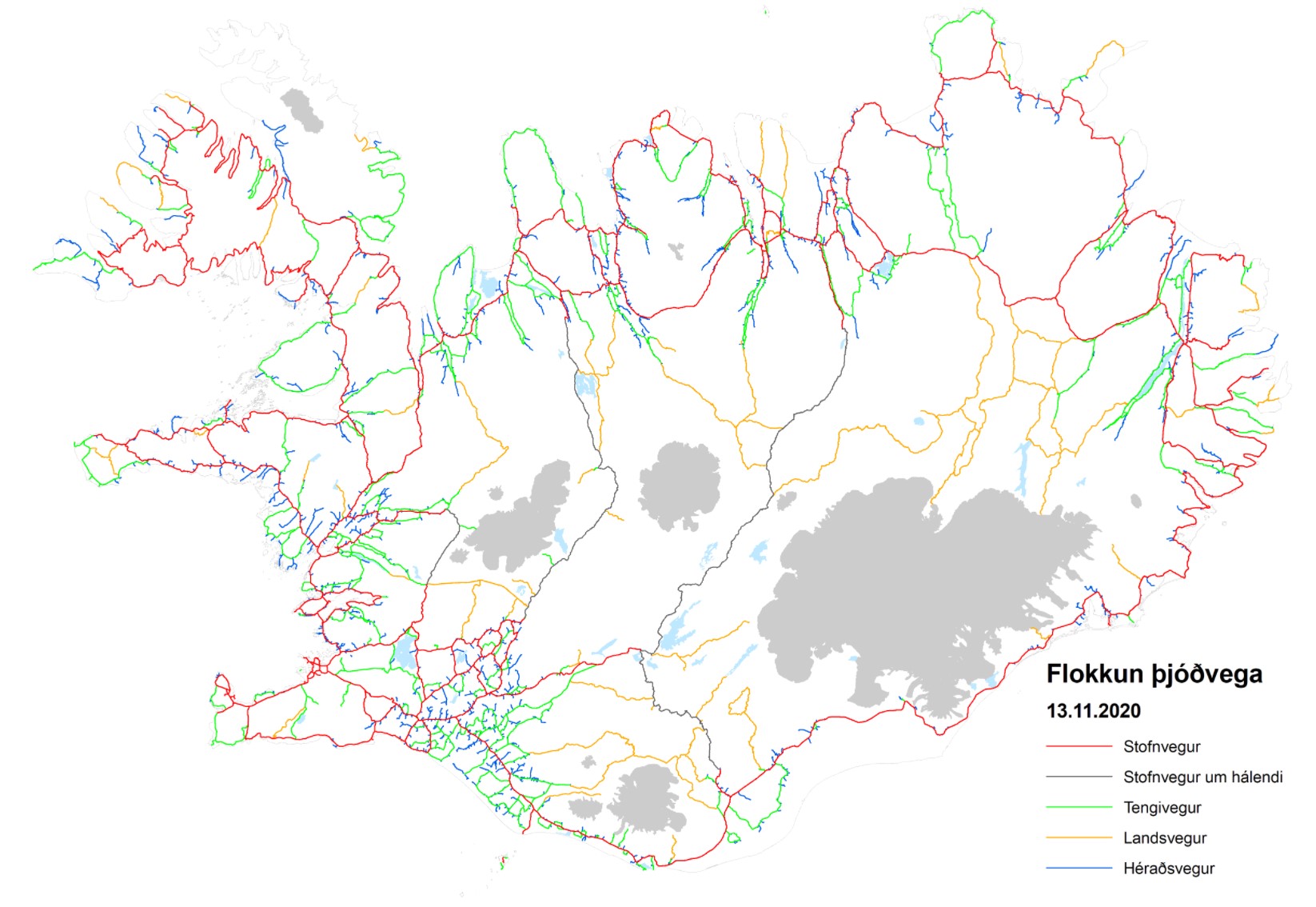
Þjóðvegir sem eru í umsjón Vegagerðarinnar. Línugögn: Miðlína þjóðvega sem heyra undir Vegagerðina skv. vegalögum. Gögnin innhalda m.a. upplýsingar um yfirborð og flokkun vegakerfisins, auk staðsetningu jarðganga. Einnig upplýsingar um yfirborðsmerkingar Punktgögn: Brýr og ræsi þ.m.t. göngubrýr yfir þjóðvegi. Ýmsar upplýsingar fylgja brúnum s.s. breidd, lengd, gerð brúarvirkis ofl. Umferðarmerki, skráning á gerð fer eftir reglugerð nr.289/1995 með síðari breytingum. Áningastaðir.