 Arctic SDI catalogue
caribou
Type of resources
Available actions
Topics
Keywords
Contact for the resource
Provided by
Formats
Representation types
Update frequencies
status
-
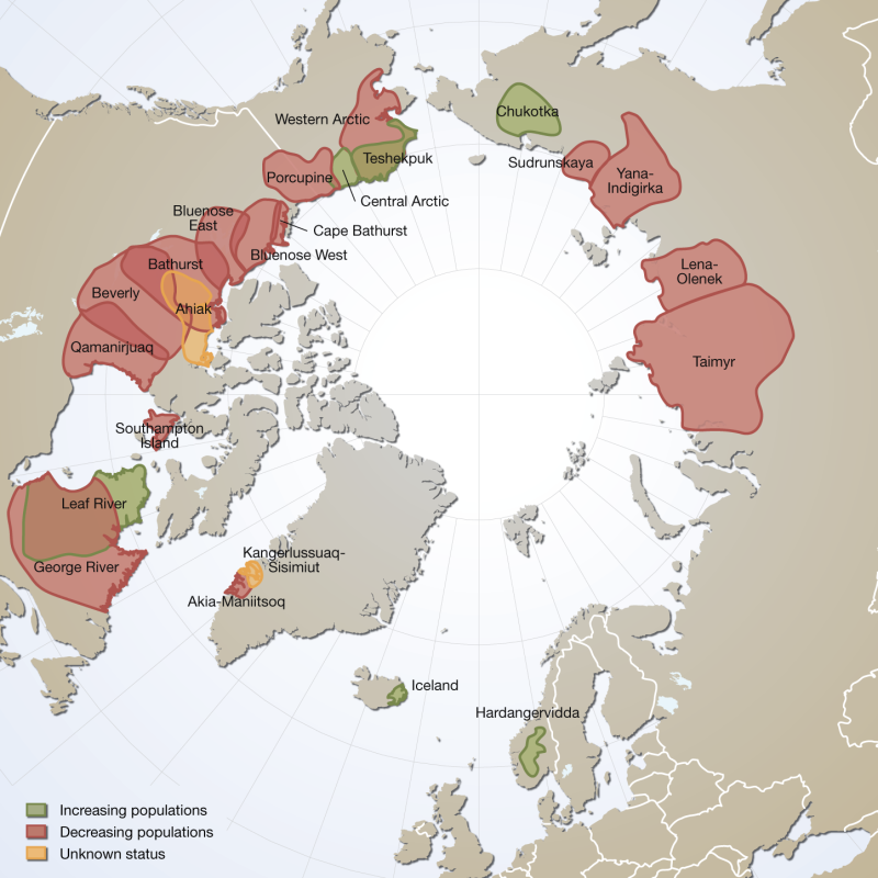
Distribution and observed trends of wild Rangifer populations throughout the circumpolar Arctic (from The Circum Arctic Rangifer Monitoring and Assessment Network, CARMA). Note: Wild boreal forest reindeer have not been mapped by CARMA and thus are not represented here. Published in the Arctic Biodiversity Trends 2010 - Selected indicators of change, INDICATOR #02 - released in 2010
-

Summer/Fall and Winter/Forest-Dwelling 2017 habitat model for caribou in the Itcha Ilgachuz area. [Season] field should be used to split the data out into separate summer/fall and winter/forest-dwelling habitat models. Model development is detailed in _Apps, C., and N. Dodd. 2016.. Caribou habitat modeling and evaluation of forest disturbance influences across landscape scales in west-central British Columbia – March, 2016. Prepared for Ministry of Forests, Lands and Natural Resource Operations, Williams Lake, British Columbia_. See also: https://catalogue.data.gov.bc.ca/dataset/7ea6556b-c113-4194-92f2-7ddb55a340b6 __Note: The 2001 habitat model covers a similar area, but is not replaced by the 2017 habitat model.__
-

Broad management guidance is applied across each Cervid Ecological Zone (CEZ) to help set local population and habitat objectives. CEZs reflect the overarching cervid management intent at the landscape level. The foundation for CEZs is Ontario’s Ecological Land Classification, with consideration given to: * cervid species ranges * landscape level variations in habitat and climate CEZs build on the existing Wildlife Management Unit network while recognizing that species and habitat ranges fluctuate over time.
-

Clear Creek Caribou, a northern mountain herd, were the focal species for this project. Reconnyx HyperFire 2 Trail Cameras were strategically deployed in caribou habitat across a gradient of disturbance. CH cameras were accessed by helicopter and CR cameras were accessed by road. All cameras were placed on game trails approximately 1.7m above the ground, and approximately 2-4m away from (but facing) the trail . O’Gorman’s Long Distance Call Lure was applied annually to holes drilled into a scent tree, or where necessary into ground vegetation or rocks, located 4-7m from the camera within the field of view. Cameras were programmed to take a single time-lapse photo daily at noon to monitor environmental changes and verify functionality. Upon heat or motion activation, cameras captured a burst of five consecutive photos with no delay between activations. Cameras were moved if >5 independent photos of humans were captured, no target species were detected, or if there was an active dwelling or camp within 1km. This is a collaborative project with the First Nation of Na-Cho Nyäk Dun (FNNND) and Government of Yukon Department of Environment, with support from Tr’ondëk Hwëch’in. It was undertaken with the financial support of the Department of Environment, the Government of Canada through the federal Department of Environment and Climate Change (Grant Number: GCXE22C217 to FNNND) and through the Canada-Yukon Nature Agreement. For more information about this data please contact ce.cameratrapping@yukon.ca. Cumulative Effects Programs Remote Camera Detections - Clear Creek 2023-24 - Data - Open government portal - Government of Yukon Cumulative Effects Programs Remote Camera Detections - Clear Creek 2024-25 - Data - Open government portal - Government of Yukon Distributed from [GeoYukon](https://yukon.ca/geoyukon) by the [Government of Yukon](https://yukon.ca/maps). Discover more digital map data and interactive maps from Yukon’s digital map data collection. For more information: [geomatics.help@yukon.ca](mailto:geomatics.help@yukon.ca)
-
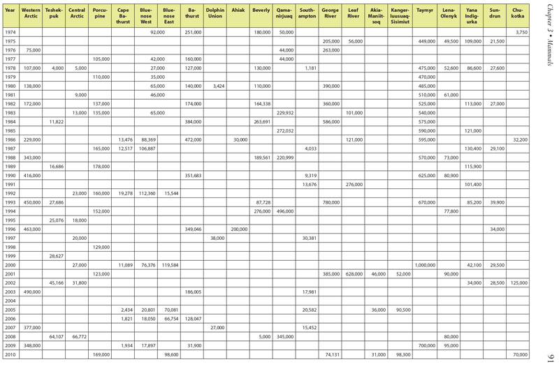
Table 3.1. Summary of historical population estimates for 22 circumpolar caribou and wild reindeer herds. Data courtesy of Circum-Arctic Rangifer Monitoring Assessment Network (CARMA) and D.E. Russell & A. Gunn; www.carmanetwork.com/display/ public/home. Data vary substantially among herds and over time in accuracy and precision, and represent only general patterns of abundance. Conservation of Arctic Flora and Fauna, CAFF 2013 - Akureyri . Arctic Biodiversity Assessment. Status and Trends in Arctic biodiversity. - Mammals(Chapter 3) page 91
-
The Broad Ecosystem Inventory (BEI) Classification provides broad regional information about the distribution of ecosystems throughout the province and the value of these ecosystems to wildlife. This work is done in order to facilitate the use of wildlife information in broad provincial and regional land and resource planning initiatives. Broad Ecosystem Units are mapped based on imagery of the provincial land base generally captured at a scale of 1:250,000. BEI mapping represents forest conditions from approximately 1995 to 2000. The BEI Classification was used to produce wildlife habitat capability and suitability mapping following Provincial Wildlife Habitat Ratings (WHR) Standards (Resource Inventory Committee 1999). Habitat classifications were based on BEI units. BEI units were evaluated and rated to determine the habitat potential (capability) and current habitat conditions (suitability) for selected wild ungulates and furbearers within each seral stage within each Broad Ecosystem Unit (and related site modifier variation) within the framework of Ecosections and Biogeoclimatic Sub-zone/Variants for their ability to supply the species’ necessary life requisites. Regional Wildlife and Habitat biologists, technicians, Forest Ecosystem Specialists, and consulting species experts provided species habitat ratings for each region of the province. Wildlife habitat capability and suitability mapping was completed for the following wild ungulates and furbearers: Northwestern Moose, Alaskan Moose, Shiras' Moose, Bison, Rocky Mountain Elk, Roosevelt Elk, Columbian Black-tailed Deer, Rocky Mountain Mule Deer, Sitka Black-tailed Deer, White-tailed Deer, Dakota White-tailed Deer, Northwestern White-tailed Deer, Boreal Woodland Caribou, Mountain Woodland Caribou, Northern Woodland Caribou, Lynx, Bobcat, and American Badger. Habitat mapping followed Provincial Wildlife Habitat Ratings (WHR) Standards (Resource Inventory Committee 1999).
-

The purpose of this dataset is to give an accurate representation of the game hunting boundaries in Manitoba. The purpose of this dataset is to give an accurate representation of the game hunting boundaries in Manitoba.Game Hunting Areas (GHAs) are defined under the Hunting Areas and Zones Regulation (220/86) of The Wildlife Act (CCSM c. W130). Game Hunting Areas are used to support boundaries for species-specific hunting seasons, harvest allocations, bag limits and associated regulations. Refer to the Hunting Areas and Zones Regulation for GHA boundary descriptions.Fields included (Alias (Field Name): Field description)OBJECTID (OBJECTID): sequential unique whole numbers that are automatically generated GHA (GHA): the number assigned to each Game Hunting Area Shape_Length (Shape_Length): the length of the feature in internal units Shape_Area (Shape_Area): area of the feature in internal units squared
-

Since they are essential environments for wildlife, eleven categories of habitats benefit from legal protection in Quebec. Together, they protect a great diversity of wildlife species, including fish, crustaceans, molluscs, certain large mammals, such as caribou and deer, as well as numerous species of seabirds and waterfowl. Among the protected habitats, there are also those of endangered or vulnerable wildlife species. ### #LOI AND REGULATIONS * Wildlife Conservation and Development Act * Wildlife Habitat Regulation * Regulation on threatened or vulnerable wildlife species and their habitats ### #LISTE LEGALLY PROTECTED WILDLIFE HABITATS * Area of concentration of waterbirds * Caribou calving area north of the 52nd parallel * Caribou use area south of the 52nd parallel * White-tailed deer containment area * Cliff inhabited by a bird colony * Island or peninsula inhabited by a bird colony * Habitat of a threatened or vulnerable wildlife species * Heron (including the nest and the 0-200 m and 200-500 m bands that surround it) * Fish habitat * Muskrat habitat * Mudflat A shape file exists for all wildlife habitats in the province of Quebec. Wildlife habitats located on mixed and private lands are also found for information purposes. ### #SOURCES CARTOGRAPHIC Wildlife habitats are digitized using as a reference, in particular: * Quebec topographic database (BDTQ); * Domain layer of the Ministry of Natural Resources and Forests (MRNF); * Administrative divisions of Quebec on a scale of 1/20,000; * Digital imagery. References may vary depending on the case. Other sources can also be used ### #MISE DATA UPDATE The updating of wildlife habitat data follows a variable planning according to the habitat category and according to the inventories carried out and the needs of regional and central departments. ### #Mise on guard: The digital version of geo-descriptive data describing wildlife habitats is produced from a legal perspective of location, protection and management of habitats. In fact, only the digital version that has been published in the Official Gazette of Quebec is recognized as legal.**This third party metadata element was translated using an automated translation tool (Amazon Translate).**