 Arctic SDI catalogue
tourism
Type of resources
Available actions
Topics
Keywords
Contact for the resource
Provided by
Years
Formats
Representation types
Update frequencies
status
Service types
-

The RFI identifies areas of land and water encircling a recreation feature or combination of features that support, or have the potential to support, one or more recreation activities. These areas are rated for their significance or importance to recreation and for their sensitivity to alteration
-
Vegetative or non-vegetative objects alongside major roads and highways preventing passers by from seeing the surrounding landscape
-
The ROS Inventory characterizes and represents recreation opportunities as mixes or combinations of settings and probable experience opportunities arranged along a continuum or spectrum of ROS classes. The spectrum is set out in terms of seven ROS classes as follows: Primitive (P), Semi-primitive Non-motorized (SPNM), Semi-primitive Motorized (SPM), Roaded Natural (RN), Roaded Modified (RM), Rural (R), Urban (U)
-
This legacy Web Map Services will no longer be maintained on an ongoing basis as of December 31, 2015. It will be removed from operations as of March 31, 2016. To see the latest in DataBC WMS services please go to http://openmaps.gov.bc.ca.
-
A direction one looks from a viewpoint towards a visual landscape. When a view is panoramic, it is to the middle of that panoramic view
-
Data relating to the planning, management, monitoring or protection of resources used for the voluntary pursuit of leisure activities and tourism in areas used for recreational purposes.
-
The VLI identifies and delineates areas of visual sensitivity near communities and along travel corridors throughout the province. It includes information about the visual condition, characteristics and sensitivity to alteration. It also houses scenic area and established Visual Quality Objective ( VQO ) attributes.
-
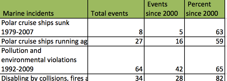
Arctic Biodiversity Assessment (ABA) 2013. Table 18.1. Marine incidents involving cruise ships in Arctic and Antarctic waters (the same vessels often alternate polar region according to season) (aggregated from reports from national coast guards, admiralty courts and insurers, and www.cruisejunkie.com).
-

This dataset divides Yukon into 9 tourism regions which are used to track wilderness tourism statistics. Note that the Yukon Vacation Planner divides Yukon into 8 similar tourism regions with somewhat different boundaries. Distributed from [GeoYukon](https://yukon.ca/geoyukon) by the [Government of Yukon](https://yukon.ca/maps) . Discover more digital map data and interactive maps from Yukon's digital map data collection. For more information: [geomatics.help@yukon.ca](mailto:geomatics.help@yukon.ca)
-
This dataset identifies locations of wilderness tourism trails. This is not a complete or up to date dataset. Distributed from [GeoYukon](https://yukon.ca/geoyukon) by the [Government of Yukon](https://yukon.ca/maps) . Discover more digital map data and interactive maps from Yukon's digital map data collection. For more information: [geomatics.help@yukon.ca](mailto:geomatics.help@yukon.ca)