 Arctic SDI catalogue
Atlantic
Type of resources
Available actions
Topics
Keywords
Contact for the resource
Provided by
Years
Formats
Representation types
Update frequencies
status
Service types
-
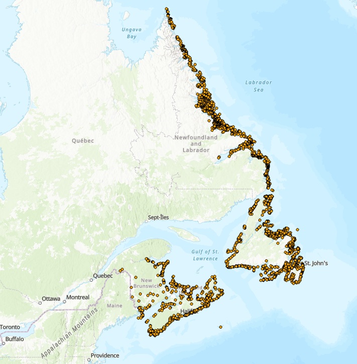
The Atlantic Colonial Waterbird Monitoring database captures geo-referenced data collected under the Atlantic Region’s Canadian Wildlife Service (CWS) Colonial Seabird Monitoring program, and data collected under CWS’ waterfowl and protected areas programs. These programs collectively monitor 22 species of colonial waterbirds breeding in the Atlantic Region of the following groups: fulmars, shearwaters, storm-petrels, gannets, gulls, terns, alcids, eiders, herons and cormorants, with the primary outcome to update information on the distribution, status, and trends of waterbirds breeding in all four Atlantic provinces. Surveys are conducted using one of three platforms: aerial, boat, or ground. Aerial surveys provide the most cost-effective way of conducting a comprehensive population census of diurnal species visible from air, namely gulls (Herring, Great Black-backed, Ring-billed, Glaucous), Black-legged Kittiwakes, Northern Gannets, terns (Arctic, Common, Roseate, Caspian), cormorants (Greater, Double-crested), Black Guillemots, and Common Eiders. Aerial surveys are also effective in identifying new colonies and provide additional information on how to most effectively conduct boat and ground surveys. Boat and ground surveys are conducted at smaller geographic scales and are necessary to obtain complementary information on the species composition of colonies and correction factors to finalize gull, tern and eider estimates obtained from the aerial surveys. Ground and/or boat surveys are also necessary to conduct colony counts of cliff-nesting birds (murres and fulmars), crevice nesting birds (razorbills and guillemots) and burrow-nesting birds (puffins, storm-petrels, shearwaters). Raw data are captured using various survey methods, including:1) visual estimates, 2) direct counts of number of individuals or apparently occupied sites and/or photo counts, 3) sub-sampling the colony through plot counts and extrapolating the estimated occupied densities over the occupied area which in turn is estimated using a variety of geographic information system approaches (e.g., Wilhelm et al. 2015). Important outcomes for how data are used include informing marine spatial planning, emergency preparedness, impact assessment of various anthropogenic threats, and COSEWIC status assessment (e.g., COSEWIC 2020). Further, these data are regularly used internally or in collaboration with partners to form the basis of peer-reviewed publications on regional, national, and/or global population trends for target species (e.g., Langlois Lopez et al. 2022, Iles et al. 2025). This dataset represents a subset of data collected from surveys led by CWS spanning from 1910 to 2024 and summarized to present, at a given colony, the year and count of birds from the most recent survey, the year and maximum count of birds within the last 20 years (if available), and the year and maximum count of birds ever recorded. In addition, CWS works closely with a variety of partners (e.g., provincial, other federal departments, academic, not-for profit organizations) to supplement colonial waterbird data collected in the Atlantic Region. To request additional census or survey data, please contact CWS. COSEWIC. 2020. COSEWIC assessment and status report on the Leach’s Storm-Petrel (Atlantic population) Oceanodroma leucorhoa in Canada. Committee on the Status of Endangered Wildlife in Canada. Ottawa. xii + 70 pp. (https://www.canada.ca/en/environment-climate-change/services/species-risk-public-registry.html). Iles, D.T., S.E. Gutowsky, A.M. Calvert, S.I. Wilhelm, J.-F. Rail, A. Hedd, H.L. Major, A.C. Smith, and G.J. Robertson. 2025. Estimating regional trajectories and trends of seabirds from sparse and inconsistent colony counts: case studies from eastern Canada with Leach’s Storm-Petrel and Atlantic Puffin. Avian Conservation and Ecology 20(2):16. https://doi.org/10.5751/ACE-02931-200216 Langlois Lopez, S., Bond, A.L., O’Hanlon, N.J., Wilson, J.M., Vitz, A., Mostello, C.S., Hamilton, F., Rail, J.-F., Welch, L., Boettcher, R., Wilhelm, S.I., Anker-Nilssen, T., Daunt, F., and Masden, E. 2022. Global population and conservation status of the Great Black-backed Gull Larus marinus. Bird Conservation International, 1–11. https://doi.org/10.1017/S0959270922000181 Wilhelm, S.I., Mailhiot, J., Arany, J., Chardine, J.W., Robertson, G.J., and Ryan, P.C. 2015. Update and trends of three important seabird populations in the western North Atlantic using a geographic information system approach. Marine Ornithology 43: 211-222.
-
The North Atlantic current (red arrows) originates in the hot and salty Gulf Stream which flows out of the Mexican gulf and follows the east coast of the USA. When this current leaves the continental shelf and moves across the North Atlantic it’s often called the North Atlantic current. The North Atlantic current provides a significant amount of heat transport to northern Europe. This heat transport is greatest in winter because the current velocity is greater in that part of the year. The North Atlantic current keeps a very constant temperature and salinity throughout the year. It gradually looses heat and salinity as it flows towards the north east and gets mixed with colder and less salty water. At the south western part of the map where the current leaves the American continental shelf the surface temperature is 15-20 oC and the salinity is approximately 36. When it reaches the inlet to the Barents Sea the surface temperature is reduced to 5 oC in the winter and 10 oC in the summer, while the salinity stays at 35 throughout the year.The North Atlantic current continues into the Polar seas through the Fram Strait west of Svalbard and into the Barents Sea (pink arrows). When it reaches these areas its quickly chilled to 2-3 oC and the salinity sinks towards 34.7.The cooling of the North Atlantic current happens when it comes into contact with the colder and less salty Arctic current (blue arrows) that flows south west towards Svalbard’s east coast, south out of the Fram Strait and south out of the Davids Strait between Greenland and Canada. This current has salinity below 34 and the temperature is between -2 oC and +2 oC. In the same way as the North Atlantic current cools on the way north east the Arctic current heats up on its way towards the south west. The Arctic current does however give a significant colder climate around the coast of Greenland and along the Canadian Labrador- and Newfoundland-coasts compared to Europe coasts.Close to the coasts both on the eastern and western side of the North Atlantic there are lighter coastal currents with salinity between 25 and 34 (green arrows). In these areas both the temperature and salinity varies greatly throughout the season. They are warmer then the North Atlantic current during the summer and colder during the winter. In the same way the salinity varies greatly throughout the year because of the varying freshwater runoffs from land.
-
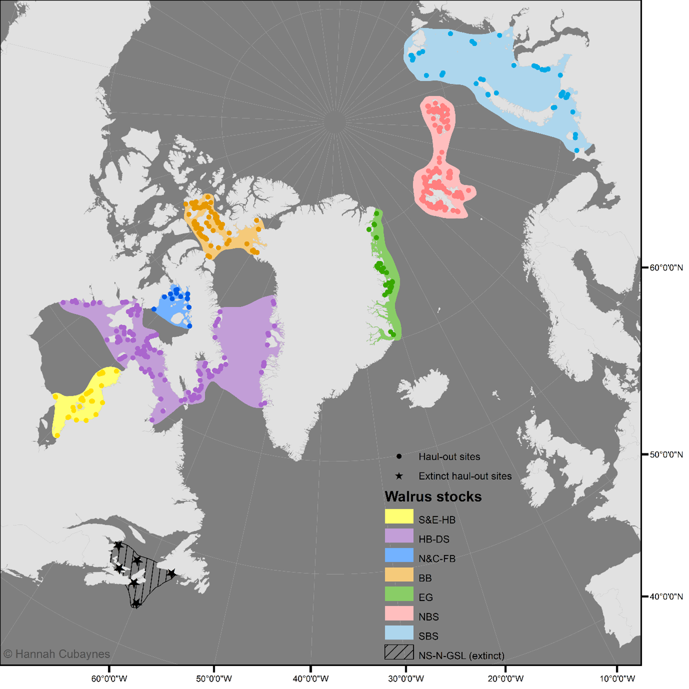
A dataset compiling all known terrestrial haul-out sites for the Atlantic walrus. The dataset comprises of the following documents: (1) the database in .csv format: walrus_haulout_database_Atlantic_caff_v4.csv; (2) the database in .shp format: walrus_haulout_database_Atlantic_caff_v4.shp; and (3) a user guidance document: user_guidance_atlantic_walrus_db.docx. The dataset will be updated annually. The latest update was 14th May 2025.
-

The North Atlantic current (red arrows) originates in the hot and salty Gulf Stream which flows out of the Mexican gulf and follows the east coast of the USA. When this current leaves the continental shelf and moves across the North Atlantic itâs often called the North Atlantic current. The North Atlantic current provides a significant amount of heat transport to northern Europe. This heat transport is greatest in winter because the current velocity is greater in that part of the year. The North Atlantic current keeps a very constant temperature and salinity throughout the year. It gradually looses heat and salinity as it flows towards the north east and gets mixed with colder and less salty water. At the south western part of the map where the current leaves the American continental shelf the surface temperature is 15-20 oC and the salinity is approximately 36. When it reaches the inlet to the Barents Sea the surface temperature is reduced to 5 oC in the winter and 10 oC in the summer, while the salinity stays at 35 throughout the year.The North Atlantic current continues into the Polar seas through the Fram Strait west of Svalbard and into the Barents Sea (pink arrows). When it reaches these areas its quickly chilled to 2-3 oC and the salinity sinks towards 34.7.The cooling of the North Atlantic current happens when it comes into contact with the colder and less salty Arctic current (blue arrows) that flows south west towards Svalbardâs east coast, south out of the Fram Strait and south out of the Davids Strait between Greenland and Canada. This current has salinity below 34 and the temperature is between -2 oC and +2 oC. In the same way as the North Atlantic current cools on the way north east the Arctic current heats up on its way towards the south west. The Arctic current does however give a significant colder climate around the coast of Greenland and along the Canadian Labrador- and Newfoundland-coasts compared to Europe coasts.Close to the coasts both on the eastern and western side of the North Atlantic there are lighter coastal currents with salinity between 25 and 34 (green arrows). In these areas both the temperature and salinity varies greatly throughout the season. They are warmer then the North Atlantic current during the summer and colder during the winter. In the same way the salinity varies greatly throughout the year because of the varying freshwater runoffs from land.