 Arctic SDI catalogue
survey
Type of resources
Available actions
Topics
Keywords
Contact for the resource
Provided by
Years
Formats
Representation types
Update frequencies
status
Service types
-
Created for distribution by the GeoYukon application as a comprehensive resource for all publicly available Parks and Protected Areas information in the Yukon Government. This data may be used directly by other applications to dynamically display Yukon data; however, it may be subject to change as data sets are updated or added.
-

A Public Right Area Object representing the spatial extent of a National or Territorial park. This cadastral framework provides a parcel base of properly structured vector data designed and suited for Geographical Information System (GIS) application and can be used for land management purposes. This data set is not be used for defining boundaries. Administrative decisions should be based on legal documents and legal survey plans. Distributed from [GeoYukon](https://yukon.ca/geoyukon) by the [Government of Yukon](https://yukon.ca/maps) . Discover more digital map data and interactive maps from Yukon's digital map data collection. For more information: [geomatics.help@yukon.ca](mailto:geomatics.help@yukon.ca)
-

Lines indicate the approximate flight path flown during aerial survey of NB forests for pests, diseases, and abiotic disturbances. Flights are conducted during clear visibility conditions, typically towards the end of June or early July. Observations are timed to optimize visibility of spruce budworm feeding characterized by reddening of current year needles on spruce and fir as they dry out. Although budworm feeding is often the focus, all types of disturbance are recorded. Polygons indicate the disturbances observed during the aerial survey. Wherever possible, the cause of the damage is reported from the air and ground surveys are used to confirmed agent if the stand is accessible.
-
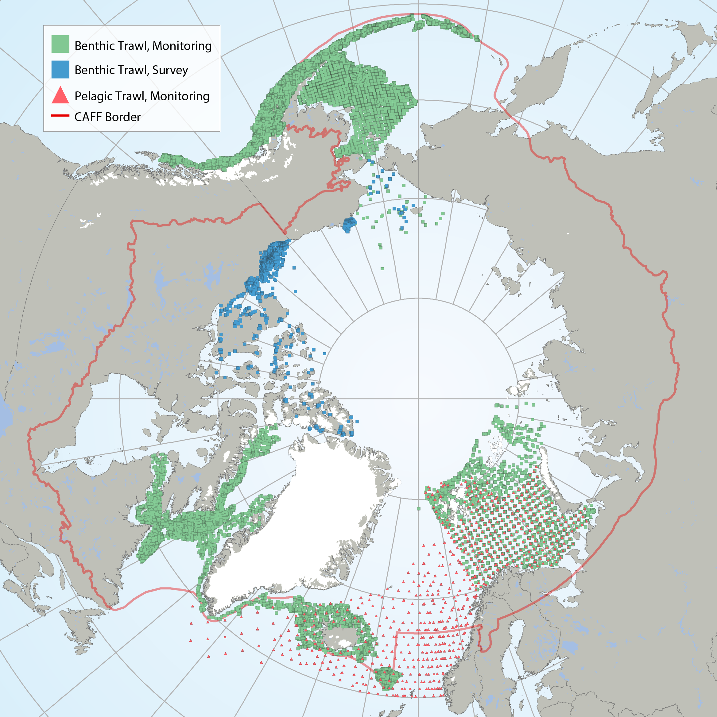
Map of contemporary marine fish data sources. Green squares indicate data from benthic trawl monitoring efforts, blue squares indicate data from benthic trawl surveys, while red triangles indicate data from pelagic trawl monitoring efforts. Red line indicates the CAFF boundary. STATE OF THE ARCTIC MARINE BIODIVERSITY REPORT - <a href="https://arcticbiodiversity.is/findings/marine-fishes" target="_blank">Chapter 3</a> - Page 112 - Figure 3.4.1
-
A Surveyed Sub-Surface Area Object that represents the spatial extent of a mineral claim to which sub-surface rights can be registered. In the Yukon, mineral claims can be classified as Quartz or Placer Claims, where as in other regions they are generically called mineral claims Distributed from [GeoYukon](https://yukon.ca/geoyukon) by the [Government of Yukon](https://yukon.ca/maps) . Discover more digital map data and interactive maps from Yukon's digital map data collection. For more information: [geomatics.help@yukon.ca](mailto:geomatics.help@yukon.ca)
-
A Public Right Area Object representing the spatial extent of a protected landscape as a result of the public interest or common good. These areas can include habitat, wilderness areas and other special management areas. This cadastral framework provides a parcel base of properly structured vector data designed and suited for Geographical Information System (GIS) application and can be used for land management purposes. This data set is not be used for defining boundaries. Administrative decisions should be based on legal documents and legal survey plans. Distributed from [GeoYukon](https://yukon.ca/geoyukon) by the [Government of Yukon](https://yukon.ca/maps) . Discover more digital map data and interactive maps from Yukon's digital map data collection. For more information: [geomatics.help@yukon.ca](mailto:geomatics.help@yukon.ca)
-
Surveyed Easements are a Limited Right Area Object representing the spatial extent of an easement or right of way affecting a Real Property. Distributed from [GeoYukon](https://yukon.ca/geoyukon) by the [Government of Yukon](https://yukon.ca/maps) . Discover more digital map data and interactive maps from Yukon's digital map data collection. For more information: [geomatics.help@yukon.ca](mailto:geomatics.help@yukon.ca)
-
Lines indicate the approximate flight path flown during aerial survey of NB forests for pests, diseases, and abiotic disturbances. Flights are conducted during clear visibility conditions, typically towards the end of June or early July. Observations are timed to optimize visibility of spruce budworm feeding characterized by reddening of current year needles on spruce and fir as they dry out. Although budworm feeding is often the focus, all types of disturbance are recorded. Polygons indicate the disturbances observed during the aerial survey. Wherever possible, the cause of the damage is reported from the air and ground surveys are used to confirmed agent if the stand is accessible.