 Arctic SDI catalogue
CTD
Type of resources
Available actions
Topics
Keywords
Contact for the resource
Provided by
Years
Formats
Representation types
Update frequencies
status
-

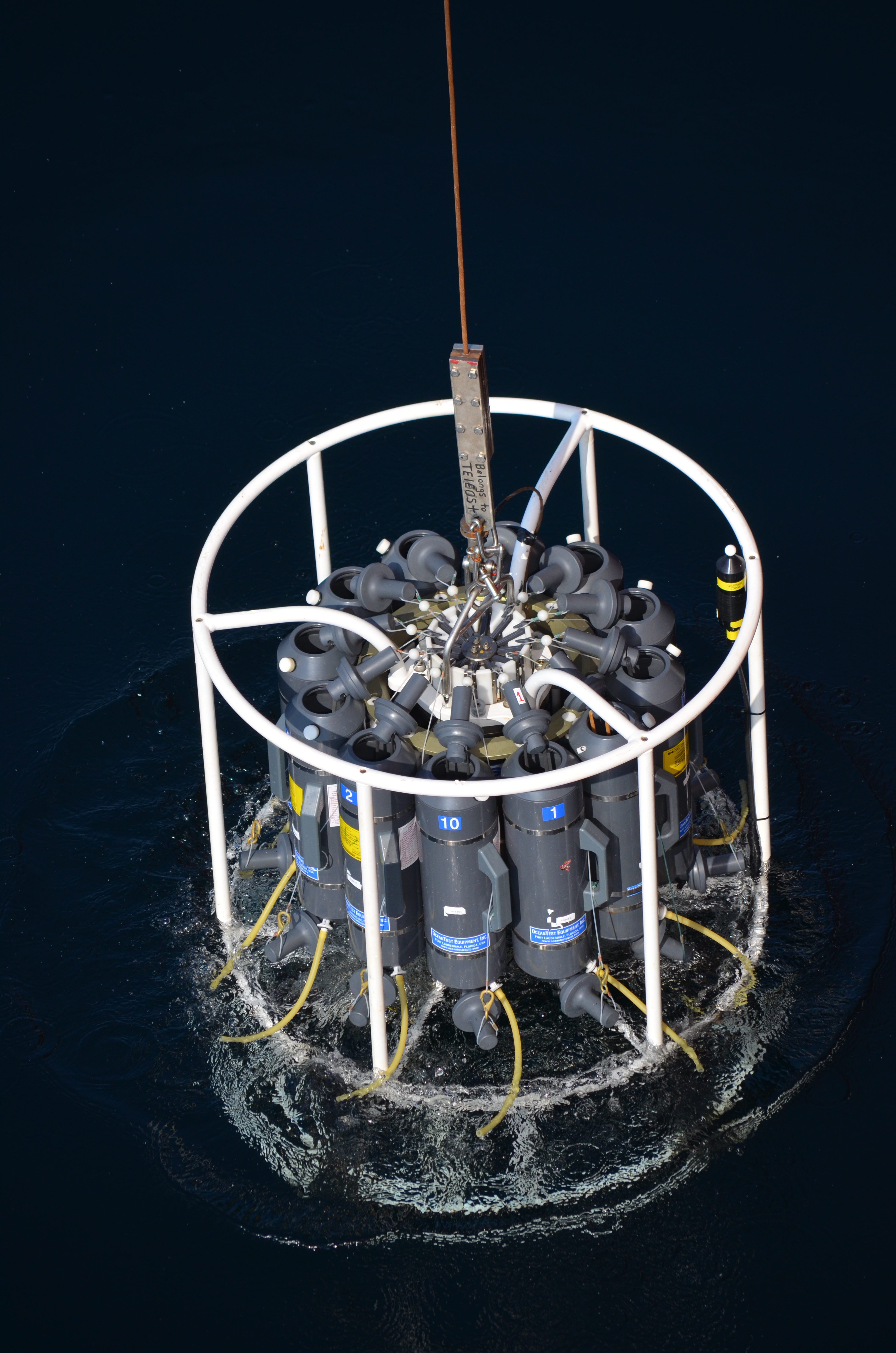
A systematic oceanographic monitoring program was initiated in September 1989 at twenty-five monitoring stations in the Passamaquoddy Bay area and approaches by Dr. Shawn Robinson based out of the St. Andrews Biological Station (SABS). Stations were established in a uniform grid pattern of two arcminutes latitude and longitude over the study area in order to develop a database on the spatial patterns of water properties. Monthly measurements of the water column for the temperatures and salinity at all stations was completed using a Seacat SBE 19 internally recording CTD from Sea-bird Electronics Inc. The CTD was programmed to record conductivity, temperature, and depth at a frequency of 2 hz, corresponding to 2 measurements per meter of water depth. CTD casts were recorded for each of the 25 stations in the study area monthly using the R/V Pandalus, and later the CCGS Viola M. Davidson based out of SABS. The CTD was configured such that the sensors were oriented towards the benthos and the CTD was then attached to a hydraulic winch on the deck of the ship by a stainless steel cable one meter above a weight, and lowered 1 m below the water's surface in order for the CTD to equilibrate for one minute. The CTD was then lowered at 1 m/s to the benthos using a metered block on the winch to determine when the CTD had reached the maximum depth at that station. Once the weight had touched the bottom, the CTD was retrieved from the water, turned off, and placed in a bucket of fresh seawater in order to minimize equilibration time at the next station. Initially, the CTD measured salinity via water forced through the salinity cell with the drop rate of 1 m/s, but in August 1992, a pump was mounted on the CTD in order to provide a more consistent flow of water across the salinity cell. Surface temperatures were measured from bucket samples collected upon arriving at each station using a hand-held mercury thermometer at each station, and Secchi disk measurements were recorded. All data were downloaded from the CTD upon return to SABS using a DFO computer and the proprietary Sea-Soft software. Downcast data from each profile was retained, binned into 1 m intervals, and processed to remove data spikes, density inversions, and anomalies due to inadequate instrument equilibration. Processed data was then stored in the DFO's Oracle database (PTRAN) under the IMTA_SABS schema in the INVHYD and INVINF tables. Station numbers and locations are recorded in the CTD_STATIONS table in the IMTA_SABS schema. Cite this data: Robinson, S. Data of: Passamaquoddy Bay monthly Conductivity Temperature and Depth (CTD) sampling (1989 - 2018). Published: October 2019. Coastal Ecosystems Science Division, Fisheries and Oceans Canada, St. Andrews, NB. https://open.canada.ca/data/en/dataset/12184962-7879-4214-aef0-b31162f04a27
-

This dataset was compiled as part of a multiyear effort lead by Fisheries and Oceans Canada (DFO) to support sustainable aquaculture regulation in the Coast of Bays, an area of the south coast of Newfoundland. It is the second of a series aiming to provide an oceanographic knowledge baseline of the Coast of Bays. This dataset includes temperature, salinity, and dissolved oxygen concentration profiles collected during CTD surveys, each survey containing a varying number of casts/profiles taken within the area of interest. In total, 760 profiles from 11 surveys, executed over 276 stations, were collected from June 2009 to November 2013. Data were processed and quality controlled using the instrumentation manufacturer guidelines, custom tools as well as visual inspection. Data are provided in tab-delimited text-based format compatible with most data processing language and tools (e.g. MS. Excel) as well as with the Ocean Data View software (https://odv.awi.de/) for rapid visualisation. A summary of the CTD profiles and stations surveyed is also provided as a comma separated values (CSV) file. A full description of the data and of its use in the context of the motivating project can be found in http://www.dfo-mpo.gc.ca/csas-sccs/Publications/ResDocs-DocRech/2017/2017_077-eng.html. Analyses from this dataset were presented during a Canadian Science Advisory Secretariat (CSAS) meeting which took place in St John’s in March 2015 (http://www.dfo-mpo.gc.ca/csas-sccs/schedule-horraire/2015/03_25-26b-eng.html) and from which a Science Advisory Report (http://www.dfo-mpo.gc.ca/csas-sccs/Publications/SAR-AS/2016/2016_039-eng.html) and Proceedings (http://www.dfo-mpo.gc.ca/csas-sccs/Publications/Pro-Cr/2017/2017_043-eng.html) were published.
-

The objective of this project was to locate the mixing zones in the coastal environment on the north shore of the lower estuary, which are caused by the friction of the waters on the bottom and measure the effects of these mixing zones on the modification of the water bodies and the productivity potential of adjacent areas, using phytoplankton biomass and size structure as an indicator of productivity. Temperature and salinity profiles were measured using CTD and water sampling was done with a Niskin bottle to try to detect the signature of the mixture and to determine if nutrient salts and/or productivity are greater in adjacent areas. Sampling took place in 3 outings from 3 stations organized in a 100 NN transect which were carried out at the start of the season (June 30), mid-season (August 16) and end of the season (October 9). The transects were each composed of three stations ranging from 10 m depth near the coast to 50 and 75 m, depending on the transect, moving away from the coast. Samples were collected for nutrients and phytoplankton biomass (> 0.7 µm and > 5 µm) analysis at depths of 1, 10, 25 and 50 m. The optical transparency of water was also measured by Secchi disk. The first file provided “donnees_profils_data” is a summary of the CTD profils of every station. The second file “donnees_discretes_discret_data” contains the results of the water sample analysis. The file “Identification_station_identification” describe the repartition of consecutives among stations. This project was funded by DFO Coastal Environmental Baseline Program under Canada’s Oceans Protection Plan. This initiative aims to acquire environmental baseline data contributing to the characterization of important coastal areas and to support evidence-based assessments and management decisions for preserving marine ecosystems.
-
Profiles collected during the cruise GLICE on RV Sanna (August 2022) in Disko Bay
-
Measurement data on the "Rossiya" icebreaker.This dataset is included the following parameters:temperature of water,salinity,dencity.Additionally, meteorological data are presented:wind speed,wind direction, air temperature, visibility.
-
The Coastal Environmental Baseline Program is a multi-year Fisheries and Oceans Canada initiative designed to work with Indigenous and local communities and other key parties to collect coastal environmental data at a series of sites across Canada, to build a better understanding of existing marine ecological conditions. The program began data collection in 2019, and with the onset of Phase 2 in 2023, the Maritimes region study area was expanded and renamed ‘Northwest Fundy Shores’. A physical oceanography program was designed to align with the oceanographic interests and data needs of local interest holders. Starting in 2023, oceanographic parameters including water temperature, salinity, depth and turbidity have been monitored at a series of locations in Passamaquoddy Bay, the St. Croix River, and along the Bay of Fundy coast, including the Musquash estuary Marine Protected Area (MPA). This dataset includes seasonal CTD (conductivity, temperature and depth) and turbidity data starting in spring 2023. Instruments are maintained through the winter months at a limited number of sites. Data collection methods are primarily moored instruments on the bottom in water depths of 5-90 meters, and a few buoyant surface floats. Overall, this dataset captures seasonal dynamics in near-shore marine environments in Passamaquoddy Bay, the St Croix River, the Bay of Fundy and the Musquash MPA. Cite this data as: Coastal Environmental Baseline Program (Maritimes Region), Northwest Fundy Shores conductivity, temperature and depth data. Published in May 2025. Coastal Environmental Baseline Program. Coastal Ecosystems Science Division, Fisheries and Oceans Canada, St. Andrews, N.B. 14-02-2025
-

The Coastal Environmental Baseline Program is a multi-year Fisheries and Oceans Canada initiative designed to work with Indigenous and local communities and other key parties to collect coastal environmental data at six pilot sites across Canada (Port of Vancouver, Port of Prince Rupert, Lower St. Lawrence Estuary, Port of Saint John, Placentia Bay, and Iqaluit). The goal of the Program is to gather local information in these areas in effort to build a better understanding of marine ecological conditions. The Maritimes region has developed a physical oceanography program to align with the oceanographic interests and data needs of local communities and stakeholders, with the goal of sharing this information via open data. Starting in 2019, oceanographic parameters including temperature, salinity, depth, turbidity and currents have been continuously monitored at a series of locations covering a broad range of environments in the Port of Saint John and approaches vicinity, including the lower Saint John and Kennebecasis rivers, coastal fringe marshes and embayments, as well as the Musquash estuary Marine Protected Area (MPA). This dataset includes CTD data starting in 2019 and turbidity data from August 2020. Data collection methods range from bottom-mounted instruments in water depths of 10-50 meters, buoyant surface moorings, and hard-mounted instruments in intertidal zones. Intertidal data is interrupted during some low tide events, where the water level drops below the sensor, resulting in loss of functionality for periods up to 1-2 hours. Overall this dataset captures a dynamic balance between salt and fresh water on the highly tidal lower Saint John river, coastal seasonal dynamics in near-shore marine environments in the Musquash MPA, and the constant fluctuations of intertidal creeks and marshes. Update 2 - April 2025: included 2023-24 data Update 1 - Nov 2023: included 2022 data; removed daylight savings errors from 2019, 2020 and 2021; updated position for Evandale surface mooring.
-
The Department of Fisheries and Oceans (DFO) holds discrete oceanographic, biological, and chemical data collected throughout the St. Lawrence Estuary, the Gulf of St. Lawrence, and the Saguenay Fjord, as well as data gathered outside of these zones during non-routine surveys (collected by the Quebec region). These data come from samples taken at different depths in the water column (surface, bottom, and intermediate depths), mainly during annual scientific missions such as: - weekly monitoring at fixed stations (Rimouski, Shediac Valley) - annual multispecies surveys (Northern and Southern Gulf) - spring and fall missions of the Atlantic Zone Monitoring Program This dataset presents the variables most frequently sampled for the period 1990 to two years prior to the present, namely, salinity, dissolved oxygen concentration, chlorophyll-a concentration, nutrient concentrations (nitrite, nitrate, silicate, phosphate), pH and alkalinity. These measurements are often accompanied by data from CTD profiles (Conductivity, Temperature, Depth/Pressure) and auxiliary sensors (fluorescence, turbidity, pH). Annual synthesis of the chemical and biological oceanographic conditions of the study area have been published since 2011, and reports on zonal conditions of the four Atlantic regions of DFO are also available for certain years: https://www.dfo-mpo.gc.ca/science/data-donnees/azmp-pmza/index-eng.html This record is updated annually as new data become available. To obtain access to earlier data, less frequently sampled variables, or specifications regarding laboratory analyses (analytical methods, preservation, and storage), please contact the data management team at: gddaiss-dmsaisb@dfo-mpo.gc.ca. Notes: This publication contains data extracted from the national BioChem database (Biological and Chemical Marine Data: DFO.BioChemDatabase-BasededonneesBioChem.MPO@DFO-MPO.GC.CA). When replicate samples were present, the values were averaged, and values were grouped by variable regardless of the analysis method, preservation method, or storage method. The grouping of variables collected at the same station is based on spatial and temporal metadata: LATITUDE, LONGITUDE, DATE, and TIME.
-
The cruise HM 2015617 onboard the Research Vessel Håkon Mosby is the second and last research cruise of the project ”On Thin Ice (NICE): Role of Ocean Heat Flux in Sea Ice Melt”. NICE is led at the Geophysical Institute, University of Bergen (PI: Ilker Fer) and is funded by the Research Council of Norway (project number 229786) for the period 01.01.2014-31.12.2017
-
This dataset is included the following parameters: water temperature, salinity,air temperature,visibility (code). Research vessel:"Mikhail Somov".