 Arctic SDI catalogue
Chemistry
Type of resources
Available actions
Topics
Keywords
Contact for the resource
Provided by
Years
Formats
Representation types
Update frequencies
status
Service types
-
AqSpringChemistry in the state of Alaska
-
AqueousChemistry1_10 in the state of Alaska
-
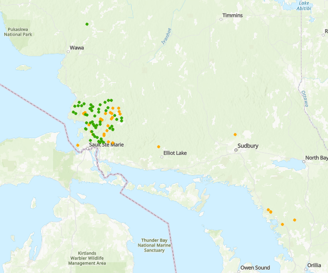
This program summarizes long term water chemistry and chlorophyll a monitoring in north central Ontario lakes developed under Canada’s Long Range Transport of Air Pollutants (LRTAP) initiative to understand and track lake acidification caused by atmospheric deposition. Centered on the intensively studied Turkey Lakes Watershed since 1979 and complemented by broader headwater and mesoscale lake networks around Sault Ste. Marie, Ontario, as well as a few locations near Parry Sound, Ontario, the monitoring integrates catchment scale approaches to link atmospheric inputs, watershed processes, and aquatic responses. Water chemistry measurements quantify acid–base status, major ions, nutrients, and trace metals to diagnose sensitivity to acidification, episodic stress during events such as spring snowmelt, and long term chemical recovery following emission controls. Chlorophyll a is used alongside chemistry to indicate phytoplankton biomass, lake productivity, and overall water quality, providing biological context for fish habitat and ecosystem condition. Together, these coordinated datasets support both detailed process studies and regional assessments of lake sensitivity, productivity, and ecological recovery across a heterogeneous landscape.
-
This dataset includes water chemistry data collected from five of the six lakes as part of the Northwestern Ontario Size Series project in 1987 and 1990 including species of nitrogen and phosphorus, carbon, chlorophyll a, conductivity, soluble reactive silica, chloride, sulphate, conductivity, sodium, potassium, magnesium, calcium, pH, alkalinity and organic acids
-

Peatlands cover approximately 12% of the Canadian landscape and play an important role in the carbon cycle through their centennial to millennial-scale storage of carbon under waterlogged and anoxic conditions. In recognizing the potential of these ecosystems as natural climate solutions and therefore the need to include them in national greenhouse gas inventories, the Canadian Model for Peatlands module (CaMP v. 2.0) was developed by the Canadian Forest Service. Model parameterization included compiling peat profiles across Canada to calibrate peat decomposition rates from different peatland types, to define typical bulk density profiles, and to describe the hydrological (i.e., water table) response of peatlands to climatic changes. A total of 1,217 sites were included in the dataset from published and unpublished sources. The CORESITES table contains site location and summary data for each profile, as well as an estimate of total carbon mass per unit area (megagrams C ha-1). Total carbon mass per unit area at each location was calculated using bulk density and carbon content through each profile. The PROFILES table contains data for depth (cm), bulk density (g cm-3), ash and carbon content (%), and material descriptions for contiguous samples through each peat profile. Data gaps for bulk density and C content were filled using interpolation, regression trees, and assigned values based on material description and/or soil classification to allow for the estimation of total carbon mass per unit area. A subset of the sites (N = 374) also have pH and pore water trace-elemental geochemistry data and are found in the WATER table. The REFERENCES table contains the full citation of each source of the data and is linked to each core location through the SOURCEDATA table. The LOOKUP table defines codes in the database that required more space than what was sufficient in the metadata tables. The data will be useful for future work on carbon stock mapping and ecosystem modelling.
-

Gridded pH of the Estuary and Gulf of St. Lawrence bottom waters including shallow waters. Data are a result of a 3D interpolation on a 1km x 1km x bottom depth grid. All the available CTD data sampled during the 2017 August and September multidisciplinary surveys were used. Purpose Since 1990, the Department of Fisheries and Oceans has been conducting an annual multidisciplinary survey in the Estuary and northern Gulf of St. Lawrence using a standardized protocol. In the southern Gulf of St. Lawrence, these bottom trawl surveys has been carrying out each September since 1971. These missions are an important source of information about the status of the marine ressources. The objectives of the surveys are multiple: to estimate the abundance and biomass of groundfish and invertebrates, to identify the spatial distribution and biological characteristics of these species, to monitor the biodiversity of the Estuary and Gulf and finally, to describe the environmental conditions observed in the area at the moment of the sampling. The southern Gulf surveys are realized using the following standardized protocol: Hurlbut,T. and D.Clay (eds) 1990. Protocols for Research Vessel Cruises within the Gulf Region (Demersal Fish) (1970-1987). Can. MS Rep. Fish. Aquat. Sci. No. 2082: 143p. The sampling protocols used for the Estuary and northern Gulf surveys are described in details in the following publications: Bourdages, H., Archambault, D., Bernier, B., Fréchet, A., Gauthier, J., Grégoire, F., Lambert, J., et Savard, L. 2010. Résultats préliminaires du relevé multidisciplinaire de poissons de fond et de crevette d’août 2009 dans le nord du golfe du Saint-Laurent. Rapp. stat. can. sci. halieut. aquat. 1226 : xii+ 72 p. Bourdages, H., Archambault, D., Morin, B., Fréchet, A., Savard, L., Grégoire, F., et Bérubé, M. 2003. Résultats préliminaires du relevé multidisciplinaire de poissons de fond et de crevette d’août 2003 dans le nord du golfe du Saint-Laurent. Secr. can. consult. sci. du MPO. Doc. rech. 2003/078. vi + 68 p. Annual reports are available at the Canadian Science Advisory Secretariat (CSAS), (http://www.dfo-mpo.gc.ca/csas-sccs/index-eng.htm). Bourdages, H., Brassard, C., Desgagnés, M., Galbraith, P., Gauthier, J., Légaré, B., Nozères, C. and Parent, E. 2017. Preliminary results from the groundfish and shrimp multidisciplinary survey in August 2016 in the Estuary and northern Gulf of St. Lawrence. DFO Can. Sci. Advis. Sec. Res. Doc. 2017/002. v + 87 p.
-

The study involved sampling during a winter subsistence fishery at Brock Lake in November 2003, and a physical, chemical and biological assessment of the lake in July 2004 and July 2005. Data including physical, chemical and biological variables were published as Roux, M.-J., Harwood, L. A., Illasiak, J., Babaluk, J.A., and de Graff, N. 2011. Fishery resources and habitats in a headwater lake of the Brock River, NT, 2003-2005. Can. Manuscr. Rep. Fish. Aquat. Sci. 2932: viii + 61 p.
-

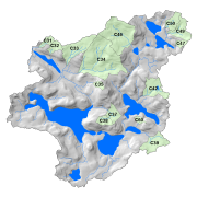
This dataset contains average concentrations of water chemistry collected from stream catchments C31, C32, C33, C34, C35, C37, C38, C39, C42, C46, C47, C49, and C50 in the Turkey Lakes Watershed, approximately 60 km northwest of Sault Ste. Marie, Ontario, Canada. These are average concentrations recorded from 1981-2018 in milligrams per litre (mg/L) of major ions (Ca, Mg, K, Na, SO4, Cl, NO3-N, NH4-N) and some nutrients (TP, TN) collected by the Great Lakes Forestry Centre. Samples are collected according to variable schedules such that frequency generally increased with increasing stream flow, (sampling period was shortest during spring runoff, 1-3 days, and longest during winter, 2-3 weeks). Sampling was accomplished by rinsing an appropriately cleaned 2-litre, polyethylene bottle at least 3 times with stream water followed by immersion to collect the final sample. Care was taken to not disturb the stream sediments throughout the sampling procedure. pH and conductivity testing is completed right after sampling. Other chemical analyses are completed by the Great Lakes Forestry Centre in Sault Ste. Marie within 2 weeks of collection. Sample integrity was maintained through storage in the dark at 4 degrees Celsius and analyzed at room temperature.
-
The Turkey Lakes Watershed Study (TLWS) was established in 1979 and is one of the longest running ecosystem studies in Canada. It is 10.5 km2 and is located approximately 60 km north of Sault Ste. Marie, Ontario at the northern margin of the Great Lakes – St. Lawrence forest region. Researchers from Natural Resources Canada, Environment Canada and Fisheries and Oceans Canada established the research watershed to evaluate the impacts of acid rain on terrestrial and aquatic ecosystems. Since its inception, the study has taken a multi-disciplinary approach to investigating the processes that govern ecosystem responses to natural and anthropogenic perturbations. The goal of the TLWS is to obtain a whole-ecosystem analysis of the biogeochemical processes operating at the site. This permits system models to be developed and validated. The holistic approach that has been adopted from the outset allows research to evolve and expand from its original acidification focus to include evaluations of other environmental issues. Partnerships and collaboration are part of the founding principles behind the TLWS to improve our ability to measure, model and predict effects of human activity on ecosystem function. Over time, research and monitoring have expanded to explore the effects of forest harvesting, climate change, aquatic habitat manipulations and toxic contaminants. Advancements of our scientific knowledge of forest ecosystems and a baseline of long-term environmental data enables study results to inform Canadian governments on environmental policy and forest management legislation. Hydrological, meteorological, and vegetation data collected by scientists at the Great Lakes Forestry Centre is included in this directory. Experimental sites and scientific investigations in the TLW are summarized in the compendium document. Visit our website at:
-
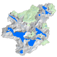
This dataset contains annual mean stream water flow/discharge data derived from daily means for headwater streams draining forested hillslopes measured at stream catchments C31, C32, C33, C34, C35, C37, C38, C39, C42, C46, C47, C49, and C50 in the Turkey Lakes Watershed, approximately 60 km northwest of Sault Ste. Marie, Ontario, Canada. This data set is recorded as annual mean flow by calendar year (January-December in litres per second), annual mean flow by water year (October to September in litres per second), and annual number of zero flow days by water year. Daily mean flows that were used to derive this data set were recorded from 1981-2012 by the Great Lakes Forestry Centre, and are reported for 1981-2011 due to some inaccuracies throughout the 2012 data. Hydrological gauging stations employ "flow-control" 120 degree V-notch weirs (catchments 31, 33, 34, 37, 39, 42, 46, and 47), 90 degree V-notch weirs (catchments 32, 35, and 49), and 60 degrees V-notch weirs (catchment 38) to facilitate monitoring of stream discharge. Water "stage" or depth within the structure (e.g. in the pool behind the weir notch) is automatically and continuously recorded by chart recorders (Leupold & Stevens A-71 SE Water Level Recorder) from 1981-2003. Capacitance rods (Trutrack WT-HR 1000) installed in stilling wells replaced the chart recorders over the period of 2002 to 2003 and were used until 2012. The capacitance rods logged data at 1 hour intervals for the majority of their use and then averaged to a daily rate. Manual stage measurements have been taken intermittently when synoptic water chemistry samples were taken throughout the years. Stage data are then converted to a continuous record of flow using the relationship between stage and discharge measurements.