 Arctic SDI catalogue
Drinking water
Type of resources
Available actions
Topics
Keywords
Contact for the resource
Provided by
Formats
Representation types
Update frequencies
status
Scale
-

Polygon features showing various zones of protection around drinking water system intakes/wellheads. A drinking water system is any domestic system servicing anything other than a single-family dwelling, as defined in the Drinking Water Protection Act. Zone of protection is a broad term that represents a wide variety of areas as they have been delineated in their corresponding report. The methods and processes used to delineate these zones vary based on several factors including, but not limited to, population, vulnerability, hydrologic/hydrogeologic parameters, etc. For the use of this dataset, the term Protection Zone means that protection measures should be considered and/or implemented in these areas due to the importance of these areas supplying drinking water to their water system users. Protection Zone does not mean that protection measures have been implemented in these areas, nor that protection measures are not required beyond the boundary of these areas. This is one of three Drinking Water Sources datasets (along with the DWS - Intakes/Wellheads points dataset, and DWS - Source Areas polygons dataset). Note: these polygons have unique Protection Zone IDs used to relate them to the Intakes/Wellhead points.
-
Polygon features representing the geographical extent of a source area that contributes water to a drinking water system. A drinking water system is any domestic system servicing anything other than a single-family dwelling, as defined in the Drinking Water Protection Act. Source Area is a broad term used to describe any area that could potentially contribute water to the drinking water system; it does not mean that hydrologic analyses have been completed to determine likelihood of connectivity. These source areas most often represent the entire aquifer extent (for ground water systems) or the watershed upstream from the intake (for surface water systems). This is one of three Drinking Water Sources datasets (along with the DWS - Intakes/Wellheads points dataset, and DWS - Protection Zones polygons dataset). Note: these polygons have unique Source Areas IDs used to relate them to the Intakes/Wellhead points.
-
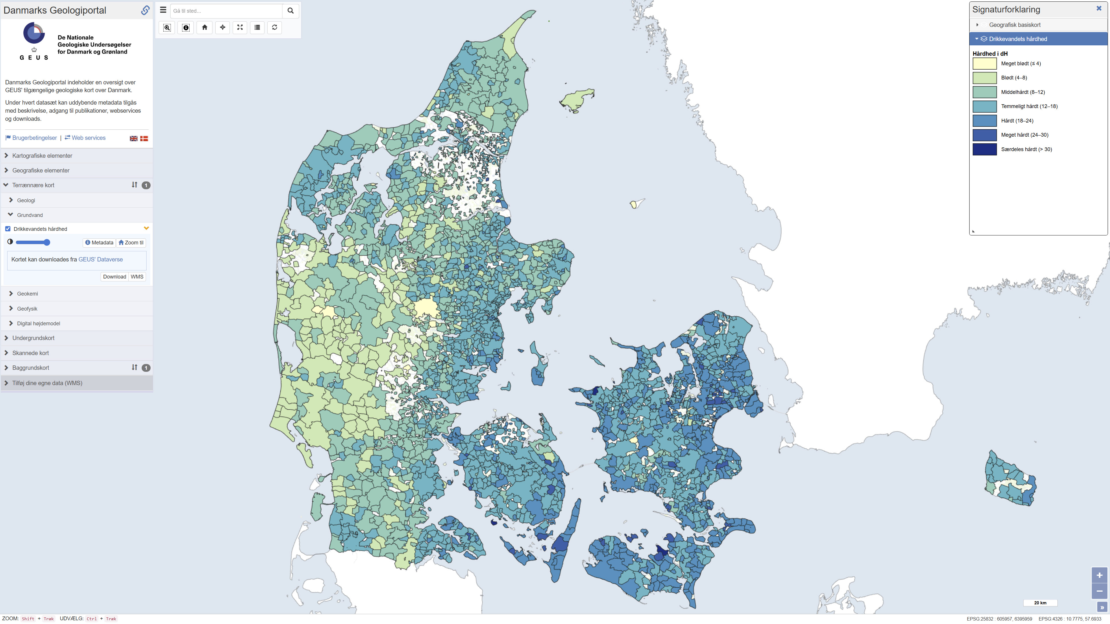
Map showing information about drinking water hardness (dH) at the level of water supply areas of public waterworks in Denmark based on quality-assured data, extracted from the national well-database Jupiter in September 2023. The hardness degree is based on the concentration of calcium and magnesium in the drinking water and has importance, for example, for the soap dosage when washing clothes: hard water requires more soap than soft water. Drinking water hardness may vary considerably from location to location and in time. Contact your water utility company to get the updated and precise figures.
-

This set of punctual data shows fire hydrants on the island of Montreal. These bollards are high devices located along streets, equipped with a water outlet supplied from the water pipes, to which the fire-fighting hoses are connected in order to ensure fire protection. The information associated with the geographic data corresponds to the date of installation, status, owner and jurisdiction. __CAUTION__: This data is published annually, so it does not include updates made during the year. For this reason, they should under no circumstances be used for engineering purposes without validation by the City. **This third party metadata element was translated using an automated translation tool (Amazon Translate).**
-
Areas of special drinking water interest (OSD) are assigned the highest priority for drinking water supply. They are delineated according to criteria including future water demand, groundwater quality, natural protection, and the preservation of existing abstraction infrastructure. The spatial extent of OSD areas may be adjusted as new knowledge becomes available through fee-financed groundwater mapping under the Environmental Objectives Act § 8a. Within these areas and abstraction catchments for public waterworks, action plans are developed under Chapter 3 of the Water Supply Act. Areas of drinking water interest (OD) represent regions with groundwater of suitable quality for drinking water, primarily relevant for smaller utilities and local abstraction. The data are provided as a vector Dataset and are accessible via OGC web services. Source data are obtained from the Danish Environmental Protection Agency’s groundwater delineations (as of November 2022) and reflect the state of knowledge at publication time.
-
Point features showing the location of intakes and/or wellheads for drinking water systems. A drinking water system is any domestic system servicing anything other than a single-family dwelling, as defined in the Drinking Water Protection Act. These locations are updated as more information is received and is therefore continually being updated and may or may not match the corresponding Point of Diversion locations available through the Water Rights dataset and application. This is one of three Drinking Water Sources datasets (along with the DWS - Source Areas polygons dataset, and DWS - Protection Zones polygons dataset). Note: the polygons all have unique polygon IDs used to relate them to these points.
-

This data layer presents the results of a modeling of net anthropogenic inputs of nitrogen and phosphorus (NANI/NAPI) carried out by Professor Roxane Maranger and Stéphanie Shousha from the University of Montreal as part of a partnership with the Ministry of the Environment, the Fight against Climate Change, Wildlife and Parks (MELCCFP). The modeling was carried out using the Net Anthropogenic Nitrogen/Phosphorus Input method applied for the first time in Quebec by ([Goyette et al., 2016]) (https://can01.safelinks.protection.outlook.com/?url=https%3A%2F%2Fagupubs.onlinelibrary.wiley.com%2Fdoi%2F10.1002%2F2016GB005384&data=05%7C02%7CAntoine.Prince%40environnement.gouv.qc.ca%7Ce9a3e849691c4a3f9bc008de4e23f624%7C4262d4ec5a674957abb6bf78aca6a6f5%7C0%7C0%7C639034113587157844%7CUnknown%7CTWFpbGZsb3d8eyJFbXB0eU1hcGkiOnRydWUsIlYiOiIwLjAuMDAwMCIsIlAiOiJXaW4zMiIsIkFOIjoiTWFpbCIsIldUIjoyfQ%3D%3D%7C 0% 7C%7C%7C&sdata=a7ktxc6ea9u4thdsbor9ojrkspdjgwno%2Fbaizkkkuaq%3D&reserved=0)) then refined in ([Shousha & Maranger, 2024] (https://can01.safelinks.protection.outlook.com/?url=https%3A%2F%2Fbesjournals.onlinelibrary.wiley.com%2Fdoi%2Ffull%2F10.1111%2F1365-2664.14733&data=05%7C02%7CAntoine.Prince%40environnement.gouv.qc.ca%7Ce9a3e849691c4a3f9bc008de4e23f624%7C4262d4ec5a674957abb6bf78aca6a6f5%7C0%7C0%7C639034113587193473%7CUnknown%7CTWFpbGZsb3d8eyJFbXB0eU1hcGkiOnRydWUsIlYiOiIwLjAuMDAwMCIsIlAiOiJXaW4zMiIsIkFOIjoiTWFpbCIsIldUIjoyfQ%3D%3D%7C0%7C%7C%7C&sdata=AdT31R8 IHMEEYRZZ1HGMTRTUAEE8XMRMAQBRNAUJDN 4% 3D&reserved=0)). The model is based on the premise that a region imports nitrogen and phosphorus to support its population and agricultural activities.**This third party metadata element was translated using an automated translation tool (Amazon Translate).**
-

The Indigenous Community Infrastructure dataset depicts infrastructure projects across Canada that are supported by Indigenous Services Canada (ISC) targeted infrastructure funding. It contains data related to project category, description, status, departmental investment and community. The dataset allows the Department to pinpoint and share information about individual infrastructure projects in Indigenous communities, in a proactive and transparent manner, to: • Showcase where and how investments are carried out • Demonstrate the Government’s commitment to address socio-economic gaps between Indigenous and non-Indigenous communities in Canada and improve access to high-quality services Projects featured in this Indigenous Community Infrastructure dataset are updated on a quarterly basis. Because some projects will benefit more than one community, the number of projects does not match the number of markers on the map or of entries in the dataset. For more information, visit https://www.sac-isc.gc.ca/eng/1526995988708/1526996020578.