Limites
Type of resources
Available actions
Keywords
Contact for the resource
Provided by
Years
Formats
Representation types
Update frequencies
status
Service types
-

The spatial extent of service territory boundaries for Ontario's local distribution companies (LDCs). ENERGY's data consumers require visualization of the service territory boundaries of local distribution companies (LDCs) to support policy development.
-

Delimitation of former municipalities before the merger in 1965 to form what is now the City of Laval.**This third party metadata element was translated using an automated translation tool (Amazon Translate).**
-

Administrative and territorial subdivisions of the City of Sherbrooke.attributs:ID - Unique identifierNumero - District numberName - Borough name - Borough name **This third party metadata element was translated using an automated translation tool (Amazon Translate).**
-
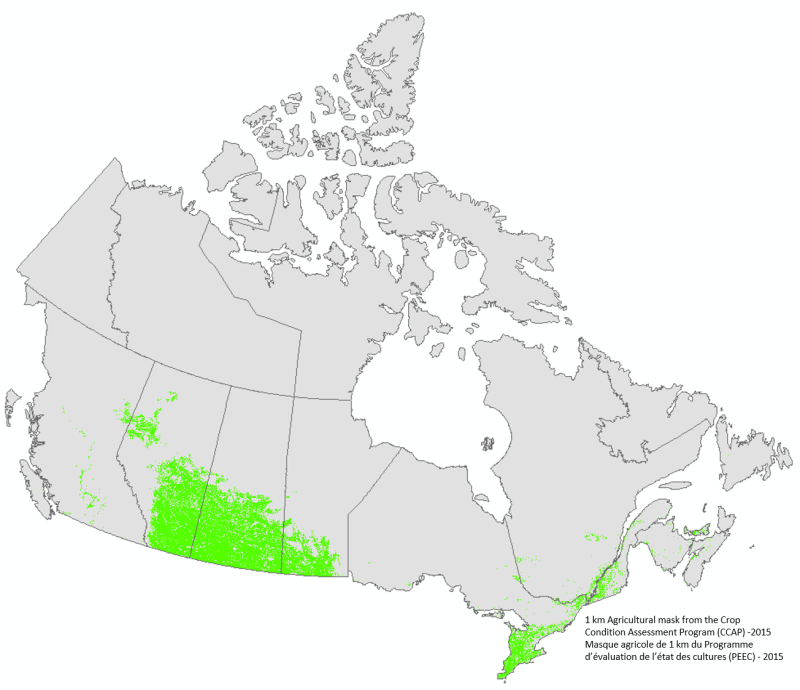
La base de données présentée ci-dessous correspond au masque agricole 1 km utilisé dans l’application du Programme d’évaluation de l’état des cultures (PEEC) de Statistique Canada. Le masque a été généré à partir des classes 110 à 199 de la classification de l’utilisation du sol de 2015 d’Agriculture Canada. La sélection a ensuite été généralisée à une résolution spatiale de 1 km. Le masque de 2015 a été utilisé pour les saisons de croissance 2015 à 2018 inclusivement.
-
Cette donnée correspond au masque agricole 230 m utilisé dans l’application du Programme d’évaluation de l’état des cultures (PEEC) de Statistique Canada. Le masque a été généré à partir des classes 110 à 199 de la classification de l’utilisation du sol de 2015 d’Agriculture Canada. La sélection a ensuite été généralisée à une résolution spatiale de 230 m. Le masque de 2015 a été utilisé pour les saisons de croissance 2015 à 2018 inclusivement.
-

The following dataset correspond to the 230 m agricultural mask from Statistics Canada’s Crop Condition Assessment Program (CCAP). The mask have been generated from the classes 110 to 199 of the 2015 Agriculture and Agri-Food Canada’s landcover classification. The selection was then generalized to a spatial resolution of 230 m. The 2015 mask was used from the 2015 to the 2018 growing seasons inclusively.
-

The following dataset correspond to the 1 km agricultural mask from Statistics Canada’s Crop Condition Assessment Program (CCAP). The mask have been generated from the classes 110 to 199 of the 2015 Agriculture and Agri-Food Canada’s landcover classification. The selection was then generalized to a spatial resolution of 1 km. The 2015 mask was used from the 2015 to the 2018 growing seasons inclusively.
-
The national agricultural ecumene includes all dissemination areas with 'significant' agricultural activity. Agricultural indicators, such as the ratio of agricultural land on census farms relative to total land area, and total economic value of agricultural production, are used. Regional variations are also taken into account. The ecumene is generalized for small-scale mapping. A new version of the agricultural ecumene is generated every census years (in vector format) since 1986. This file was produced by Statistics Canada, Agriculture Division, Ottawa.
-

Health regions are administrative areas defined by provincial ministries of health. These administrative areas represent geographic areas of responsibility for hospital boards or regional health authorities. Health regions, being provincial administrative areas, are subject to change. For complete Canadian coverage, each of the northern territories as well as the province of Prince Edward Island represents a single health region.
-

The 2022 Census Subdivision Boundary File depicts the boundaries of all 5,180 census subdivisions (CSDs), which combined, cover all of Canada. It contains the unique identifier (UID), name and type, as well as the UIDs, names and types (where applicable) of selected higher geographic levels. The 2022 Census Subdivision Boundary File is portrayed in Lambert conformal conic projection (North American Datum of 1983 [NAD83]). The 2022 Census Subdivision Boundary File is available as a national file.
 Arctic SDI catalogue