 Arctic SDI catalogue
Natural Resources
Type of resources
Available actions
Topics
Keywords
Contact for the resource
Provided by
Formats
Representation types
Update frequencies
status
-
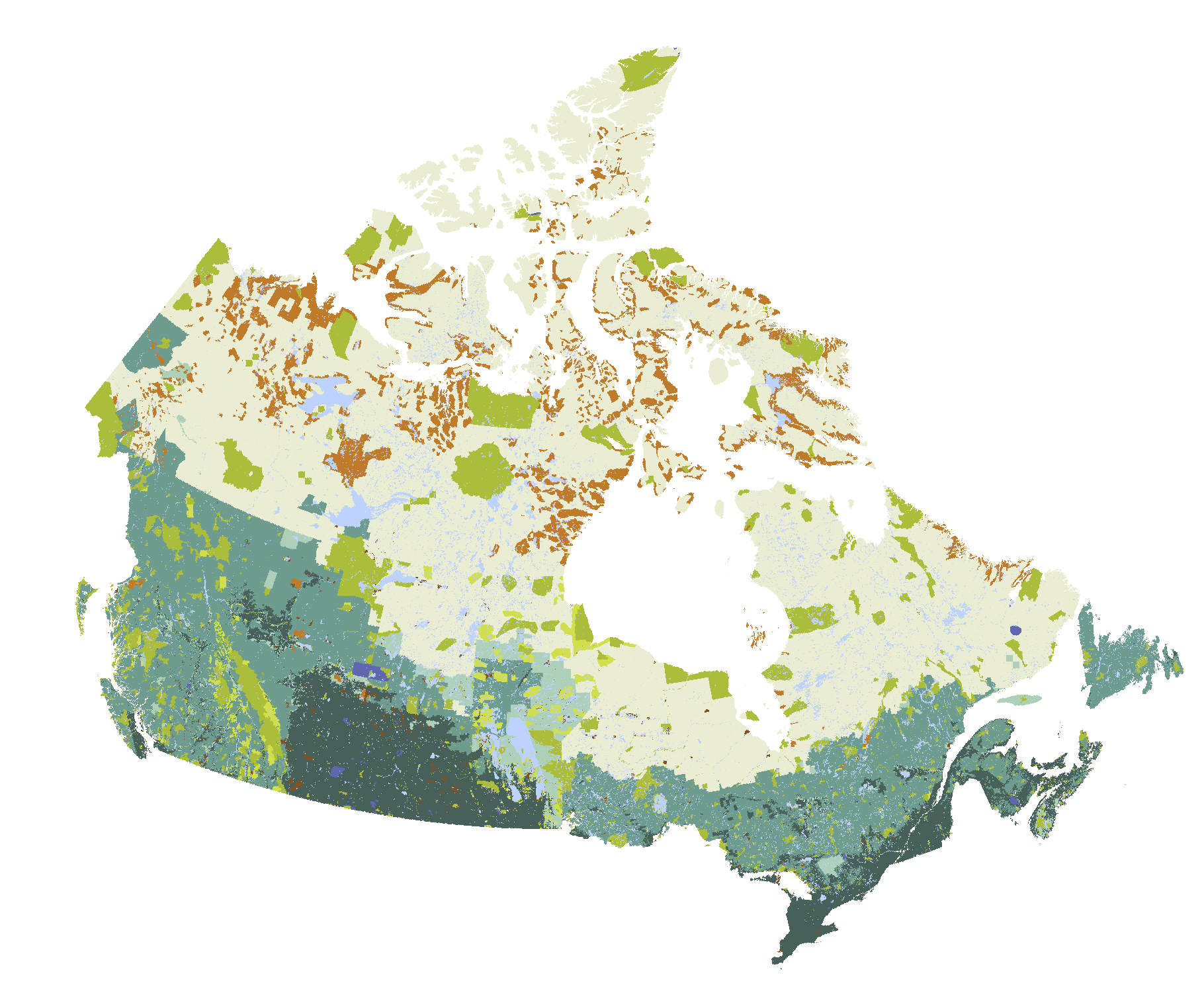
Forests cover large areas of Canada but only some of these forests are actively managed. The Map of Forest Management in Canada provides a generalized classification of forest management in Canada, including: protected areas, Treaty/Settlement Lands (including Treaty Lands identified in Final Agreements, Land Claim Agreements and Settlements), Indian Reserves, other federal reserves (including military training areas), provincial and territorial reserves and restricted use areas, private lands, short- and long-term Crown forest tenure areas and areas with no current Crown timber dispositions. The Managed Forest Map of Canada dataset provides a wall-to-wall classification of lands in Canada. It does not differentiate areas of forest from non-forest. The Managed Forest Map of Canada differs from maps defining the area designated as “managed forest” for greenhouse gas inventory reporting purposes and does not replace those maps. Instead, the Managed Forest Map of Canada shows areas that are currently managed, as of June 2017, and provides generalized management type classification for those areas. Collaborating agencies plan to update the dataset periodically as needed, and remain open to receiving advice from experts concerning refinement priorities for future versions.
-

April 2016 - March 2021 As Minister of Natural Resources and Northern Development, I am pleased to present the Five-Year Report on the Status of Forestry to the legislature for the period ending March 31, 2021. Our forests are an important part of life in Manitoba. From employment to recreation to education, this vast resource offers all Manitobans a variety of economic, environmental and cultural benefits. Managing the forests appropriately – managing them sustainably – means finding that balance between growth and protection.
-
Canadian forest management has multiple goals and varies in intensity. Governments, forest companies, Indigenous peoples, communities, and many other stakeholders are all involved in the forest management planning process. Management goals and the plans developed by professional foresters to achieve these goals differ from place to place. Canadian forests are often grouped into two categories: managed forest and unmanaged forest. This type of classification is sometimes useful, but the reality is much more complex and interesting. This interactive story map provides information on designations, ownership, forest tenures, and land protection statuses, and provides a comprehensive picture of the geography of Canada's managed forests. It has been updated from an earlier version to show land designations in 2020. **This third party metadata element was translated using an automated translation tool (Amazon Translate).**
-
Canada’s forests are managed for multiple objectives with varying degrees of management intensity. Governments, forest companies, Indigenous Peoples, communities and stakeholders are all engaged in the forest management planning process. Management objectives and the plans developed by professional foresters to achieve those objectives differ from place to place. Canada’s forests are managed for multiple objectives with varying degrees of management intensity. Governments, forest companies, Indigenous Peoples, communities and stakeholders are all engaged in the forest management planning process. Management objectives and the plans developed by professional foresters to achieve those objectives differ from place to place. People often group Canada’s forests into two categories: the managed forest and the unmanaged forest. Sometimes this type of classification is helpful, but the reality is far more complex and interesting. This interactive Story Map presents information on land designations, ownerships, tenures and protection statuses to provide a comprehensive picture of the geography of forest management in Canada. This story map has been updated from an earlier 2017 version to show land designations in 2020.
-
As Minister of Natural Resources and Northern Development, I am pleased to present to the Legislative Assembly the five-year report on the state of the forests for the period ending on March 31, 2021. As Minister of Natural Resources and Northern Development, I am pleased to present to the Legislative Assembly the five-year report on the state of the forests for the period ending on March 31, 2021. In Manitoba, forests are an integral part of life. Manitobans derive a host of economic, environmental and cultural benefits from this vast resource, in terms of employment, recreation and education. With appropriate — i.e. sustainable — forest management, it is possible to achieve a balance between growth and protection. Working with communities across the province and with local and national organizations, Manitoba continues to protect and enhance urban and natural forests by monitoring and managing invasive insects and diseases, preparing for climate change, and forecasting the effects of climate change on our forests. We do this by encouraging new and existing initiatives to reduce energy costs, including by supporting the young biomass industry, as well as by consulting and recognizing the rights of Indigenous communities across the province. **This third party metadata element was translated using an automated translation tool (Amazon Translate).**
-
Forest Management in Canada 2020 Vector Tile Layer This vector tile layer is used in the Story Map of Forest Management in Canada, 2020.
-
Forest Management in Canada web application comparing maps from 2017 and 2020. Forest Management in Canada web application comparing maps from 2017 and 2020. This web application references the Forest Management in Canada Web Map: 2017 and 2020 and is used in the Story Map of Forest Management in Canada, 2020 (Aménagement des forêts au Canada, 2020).
-
Forest Management in Canada Web Map: 2017 and 2020 Forest Management in Canada Web Map: 2017 and 2020 This web map is used in the Forest Management in Canada web application comparing maps from 2017 and 2020, both of which are part of the Story Map of Forest Management in Canada, 2020 (Aménagement des forêts au Canada, 2020). The Map of Forest Management in Canada provides a wall-to-wall classification of lands in Canada in 2017 and 2020. It does not differentiate areas of forest from non-forest. The Map of Forest Management in Canada differs from maps defining the area designated as “managed forest” for greenhouse gas inventory reporting purposes and does not replace those maps. Instead, the Map of Forest Management in Canada shows areas that are currently managed, and provides generalized management type classification for those areas. Collaborating agencies plan to update the dataset periodically as needed, and remain open to receiving advice from experts concerning refinement priorities for future versions. All forest management classification codes for 2020 are present in this web map and include:Water (Managed Forest Code 100) Protected (Managed Forest Code 20) Treaty/Settlement (Managed Forest Code 40) Federal Reserve (Managed Forest Code 31) Indian Reserve (Managed Forest Code 32) Restricted (Managed Forest Code 33) Private (Managed Forest Code 50) Long-Term Tenure (Managed Forest Code 11) Short-Term Tenure (Managed Forest Code 12) Other (Managed Forest Code 13) All forest management classification codes for 2017 are also present in this web map and include:Water (Managed Forest Code 100) Protected (Managed Forest Code 20) Treaty/Settlement (Managed Forest Code 40) Federal Reserve (Managed Forest Code 31) Indian Reserve (Managed Forest Code 32) Restricted (Managed Forest Code 33) Private (Managed Forest Code 50) Long-Term Tenure (Managed Forest Code 11) Short-Term Tenure (Managed Forest Code 12) Other (Managed Forest Code 13)
-
Manitoba's forest boundaries datasets in 2021. This data is used within Manitoba's Five Year Report on the Status of Forestry, 2016 - 2021 story map. Manitoba's forest boundaries datasets in 2021. This data is used within Manitoba's Five Year Report on the Status of Forestry, 2016 - 2021 story map. The forest boundaries included represent forest sections, forest management units, provincial forests and forest management license areas.
-
Tile layer of federal reserve, managed forest code 31 used in the Story Map of Forest Management in Canada, 2017. Tile layer of federal reserve, managed forest code 31 used in the Story Map of Forest Management in Canada, 2017. Federal Reserve lands were identified using all Directory of Federal Real Property polygons greater than 10 ha in size not classified as “parks and recreation” and provincial data sources. Data provided by Alberta Agriculture and Forestry; British Columbia Ministry of Forests; Manitoba Sustainable Development; Natural Resources Canada; New Brunswick Department of Energy and Resource Development; Newfoundland & Labrador Department of Fisheries and Land Resources; Northwest Territories Department of Environment and Natural Resources; Nova Scotia Department of Lands and Forestry; Ontario Ministry of Natural Resources and Forestry; Prince Edward Island Department of Communities, Land & Environment; Québec Ministère des Forêts, de la Faune et des Parcs; Saskatchewan Ministry of Environment; and Yukon Energy, Mines and Resources.