 Arctic SDI catalogue
Nature
Type of resources
Available actions
Topics
Keywords
Contact for the resource
Provided by
Years
Formats
Representation types
Update frequencies
status
Resolution
-

This dataset includes general category tourist accommodation establishments, whose types are: camping and caravanning or ready-to-camp sites. This data comes from the Quebec Tourism Information System (SIT Quebec). Please note that the posting of tourist accommodation establishments is governed by the Tourist Accommodation Act. The institutions in this dataset had a registration certificate in force at the time the file was published. In addition, if your interest lies in obtaining official indicators and statistics on the Quebec tourism industry, we invite you to explore the Tourism Studies and Statistics section of the Québec.ca site at the following link: https://www.quebec.ca/tourisme-et-loisirs/services-industrie-touristique/etudes-statistiques. **This third party metadata element was translated using an automated translation tool (Amazon Translate).**
-

Data on trees belonging to the municipality, referred to as “public domain”: street and off-street trees (parks and public squares). Please note that in many cases, the City's data on the spatial location of trees may be inaccurate or out of date. In addition, in some boroughs, park trees are not indicated.**This third party metadata element was translated using an automated translation tool (Amazon Translate).**
-
This dataset includes general category tourist accommodation establishments, such as outfitters. This data comes from the Quebec Tourism Information System (SIT Quebec). Please note that the posting of tourist accommodation establishments is governed by the Tourist Accommodation Act. The institutions in this dataset had a registration certificate in force at the time the file was published. In addition, if your interest lies in obtaining official indicators and statistics on the Quebec tourism industry, we invite you to explore the Tourism Studies and Statistics section of the Québec.ca site at the following link: https://www.quebec.ca/tourisme-et-loisirs/services-industrie-touristique/etudes-statistiques.**This third party metadata element was translated using an automated translation tool (Amazon Translate).**
-
This dataset includes various offers related to nature and outdoor sports. Among other things, there are national and regional parks, wildlife reserves, equestrian centers, equestrian centers, marinas, skating rinks, beaches, downhill ski centers, cross-country ski centers, golf courses, ice fishing centers. Please note that this dataset is an overview of the tourist offer in Quebec and is not intended to identify the entire offer. This data comes from the Quebec Tourism Information System (SIT Quebec). In addition, if your interest lies in obtaining official indicators and statistics on the Quebec tourism industry, we invite you to explore the Tourism Studies and Statistics section of the Québec.ca site at the following link: https://www.quebec.ca/tourisme-et-loisirs/services-industrie-touristique/etudes-statistiques.**This third party metadata element was translated using an automated translation tool (Amazon Translate).**
-
This file contains polygons delimiting ecoterritories. The City of Montreal identified 10 sectors, called ecoterritories, where the protection and enhancement of the natural spaces located there were deemed to be a priority. These are vast territories of more than 15 hectares, bringing together existing protected areas (large parks, nature reserves, etc.), urbanized areas as well as natural areas that still need to be protected and developed. Ecoterritories were established by the Policy for the Protection and Development of Natural Environments (City of Montreal, 2004), which are recognized in the Montreal Urban Plan. Ecoterritories are facilities of collective interest, defined in article 37 of the Urban Agglomeration Decree (1229-2005, 8 December 2005) (“Decree”) and its annex. This update of the ecoterritories follows the adoption of the Regulations Amending the Schedule to the Decree. Note that these changes will only be visible in the Urban and Development Plan of the Agglomération de Montréal during a future update.**This third party metadata element was translated using an automated translation tool (Amazon Translate).**
-
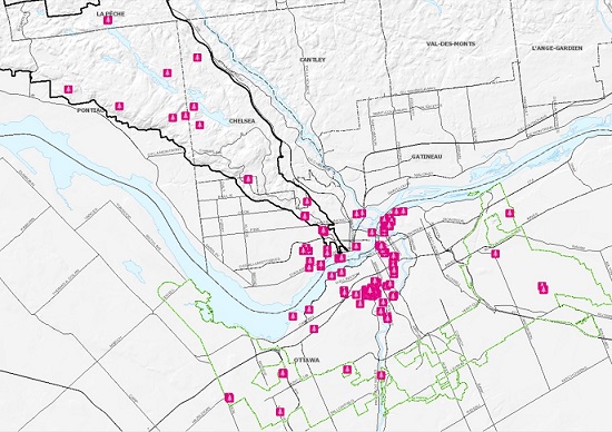
In celebration of the tremendous diversity of tree species that tell the story of our culture and history, the NCC released in September 2020 a compilation of close to 170 remarkable trees across Canada’s Capital region entitled A Living Legacy: Remarkable Trees of Canada’s Capital. An interactive map and downloadable book are available for free on the NCC’s website and will allow the public to discover distinctive features of these trees, revealing a story of the beauty of our natural heritage through the rich diversity of species thriving within Canada’s Capital. This compilation features trees according to their commonalities, which can include their physical relationship with the land, the fact that they were a source of food for Indigenous peoples, or for their contribution to the forest industry. https://ncc-ccn.gc.ca/remarkable-trees https://ncc-ccn.maps.arcgis.com/apps/MapJournal/index.html?appid=a9ba98fb7e8b4c2ba9be337235b95291
-
This data set contains the polygons delimiting the natural wastelands of the Montreal agglomeration. The boundaries of the wastelands and their type are the result of an analysis of aerial photos and/or of field visits and/or of particular ecological studies. These are constantly updated in accordance with the advancement of knowledge in the community. Some types and their limits may therefore be imprecise.**This third party metadata element was translated using an automated translation tool (Amazon Translate).**
-
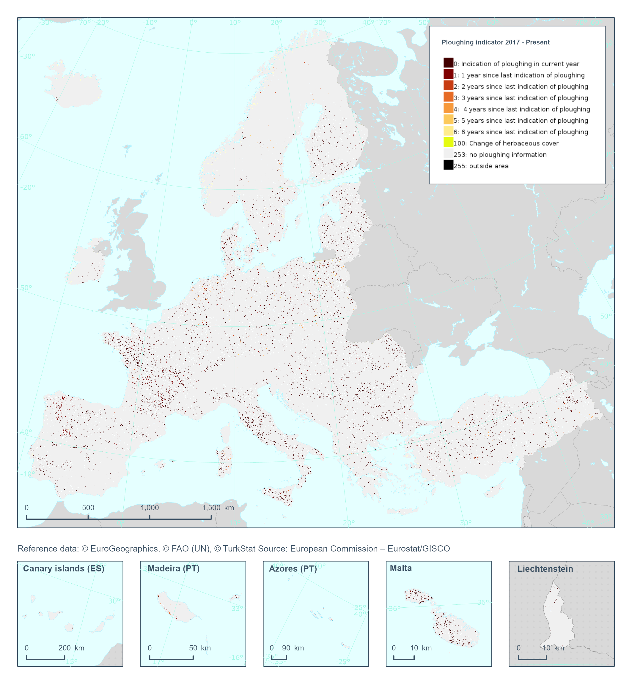
The High Resolution Layer Ploughing indicator (PLOUGH) raster product continues the 2015 and 2018 PLOUGH Layer following a rolling archive principle by adding current information and removing historic years. It indicates the number of years since the last indication of ploughing within the permanent grassland area. PLOUGH is derived by taking into account the series of binary HER layers, the BVL classifications and HR VPP PPI (Plant Phenology Index) quantiles. BVL classes 4 (crop) and 7 (overlaying layer between herbaceous and crop) indicate a ploughing event. Low HR VPP PPI quantiles indicate low vegetation at a certain time of the year. For years with missing information (2016 and earlier) the ploughing information from the historic PLOUGH product is considered which causes some issues. This dataset is provided annually starting in 2017 with 10 meter rasters (fully conformant with the EEA reference grid) in 100 x 100 km tiles covering the EEA38 countries. High Resolution Layer Grasslands product is part of the European Union’s Copernicus Land Monitoring Service. This dataset includes data from the French Overseas Territories (DOMs)
-
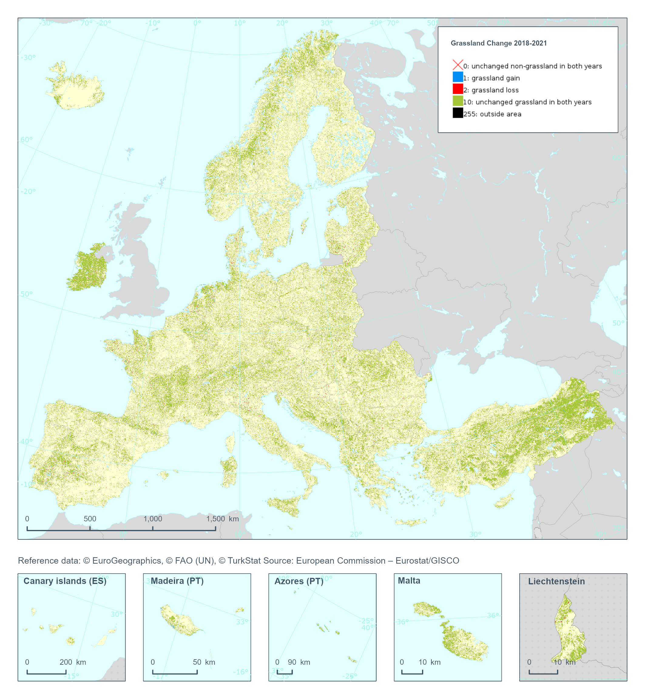
The High Resolution Layer Grassland Change (GRAC) 2018-2021 raster product at 20m resolution provides information on changes in grassland vegetation cover between the reference years 2018 and 2021. The thematic classes indicate all non-grassland areas, grassland gain and grassland loss, unchanged grassland in both years and unverified grassland gain and loss areas. This dataset is provided in 20 meter rasters (fully conformant with the EEA reference grid) in 100 x 100 km tiles covering the EEA38 countries. High Resolution Layer Grasslands product is part of the European Union’s Copernicus Land Monitoring Service. Confidence layer available for the dataset. This dataset includes data from the French Overseas Territories (DOMs)
-
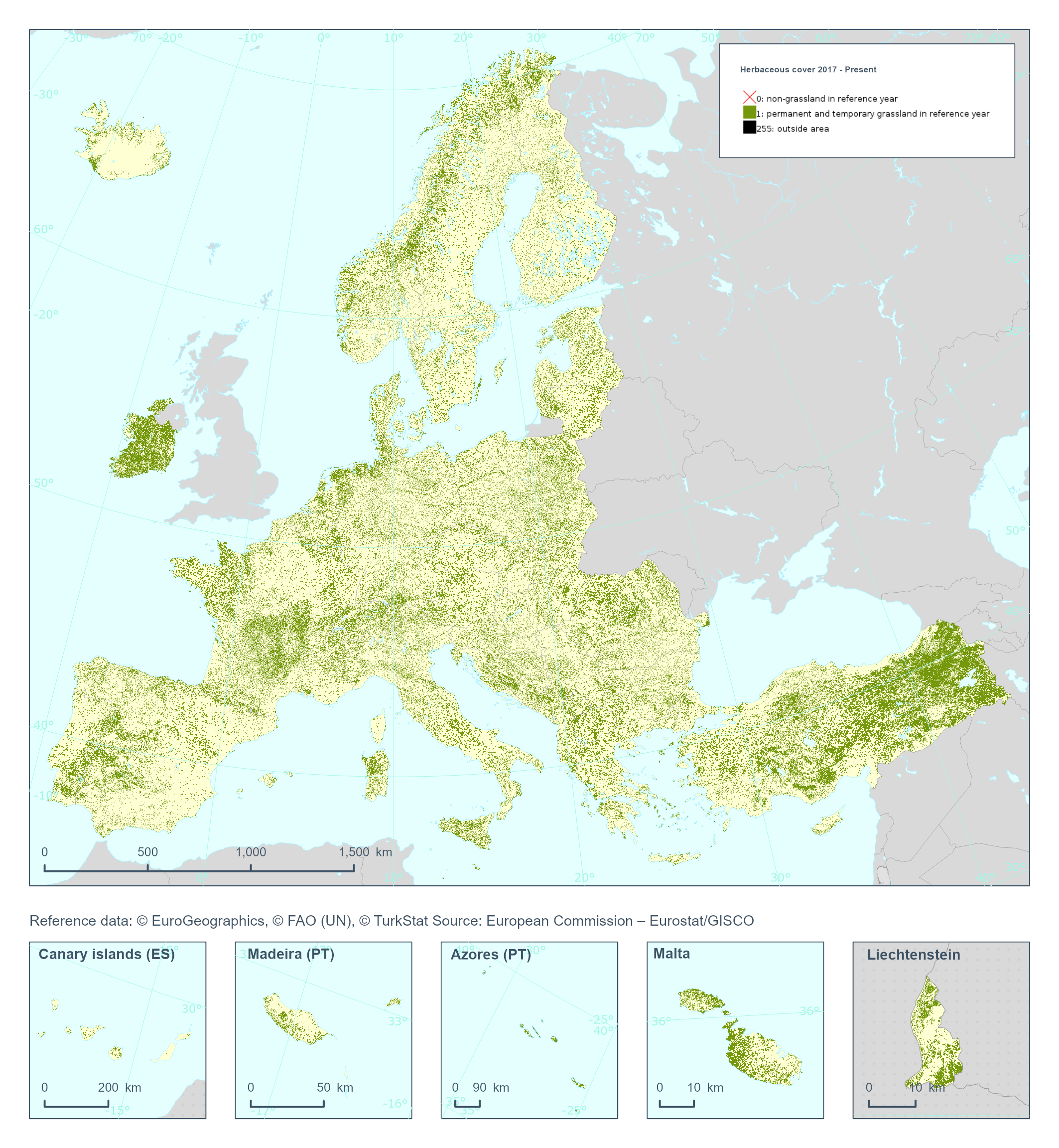
The High Resolution Layer Herbaceous cover (HER) raster product provides a basic land cover classification with 2 thematic classes (temporal and permanent herbaceous / non-herbaceous). The production of the herbaceous layer is primarily based on the probability estimates obtained from the Base Vegetation Layer (BVL) which also serves to harmonize the different vegetated HRL products (Grasslands, Tree Cover and Forests, Croplands). HER is further used as input for the Grassland status layer (GRA) extracting the permanent herbaceous in combination with the Ploughing indicator (PLOUGH). This dataset is provided annually starting in 2017 with 10 meter rasters (fully conformant with the EEA reference grid) in 100 x 100 km tiles covering the EEA38 countries. High Resolution Layer Grasslands product is part of the European Union’s Copernicus Land Monitoring Service. This dataset includes data from the French Overseas Territories (DOMs)