 Arctic SDI catalogue
culture
Type of resources
Topics
Keywords
Contact for the resource
Provided by
Years
Formats
Representation types
Update frequencies
status
Service types
-
Created for distribution by the GeoYukon application as a comprehensive resource for all publicly available Culture and Heritage information in the Government of Yukon. This data may be used directly by other applications to dynamically display Yukon data; however, it may be subject to change as data sets are updated or added.
-
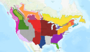
The Canadian major and minor crop field trial regions were developed following extensive stakeholder consultation and have been harmonized between the Pest Management Regulatory Agency (PMRA) and the Environmental Protection Agency of the USA. The Canadian major and minor crop field trial regions were delineated, using the geographic information system (GIS) data processing hardware and software facilities in Spatial Analysis and Geomatics Applications (SAGA), Agriculture Division, Statistics Canada. In general, the delineation process involved integration, evaluation and reference to numerous geographic data sources in a GIS to determine the best sources for the delineation. There are seven major and four minor field trial regions. Each of these regions recognizes physical characteristics, such as soils, and crops and climate, that make the region unique within the Canadian agricultural landscape. The subzones address differences within a region, generally reflected in the types of crops grown in that region. The Canadian regions, as much as possible, correspond to the U.S. regions
-
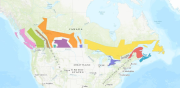
The Canadian major and minor crop field trial regions were developed following extensive stakeholder consultation and have been harmonized between the Pest Management Regulatory Agency (PMRA) and the Environmental Protection Agency of the USA. The identified regions are used for experimental studies in support of residue chemistry data requirements for the registration of new pesticide uses. The regions are based on soil type and climate and do not correspond to plant hardiness zones.
-

There are fourteen major and four minor field trial regions in Canada and USA. Each of these regions recognizes physical characteristics, such as soils, and crops and climate, that make the region unique. The subzones address differences within a region, generally reflected in the types of crops grown in that region. The Canadian regions, as much as possible, correspond to the U.S. regions. The trial regions contain number of field trials by specific crop.
-

The organizations listed are mandated or include some Gaelic language and cultural programming and/or support same.
-
Gaelic placenames in Nova Scotia contain placenames Nova Scotia Gaels have for communities in Pictou, Antigonish, Guysborough, Inverness, Victoria, Richmond and the Cape Breton Regional Municipality